Back to Don's Maps
 Back to Archaeological Sites
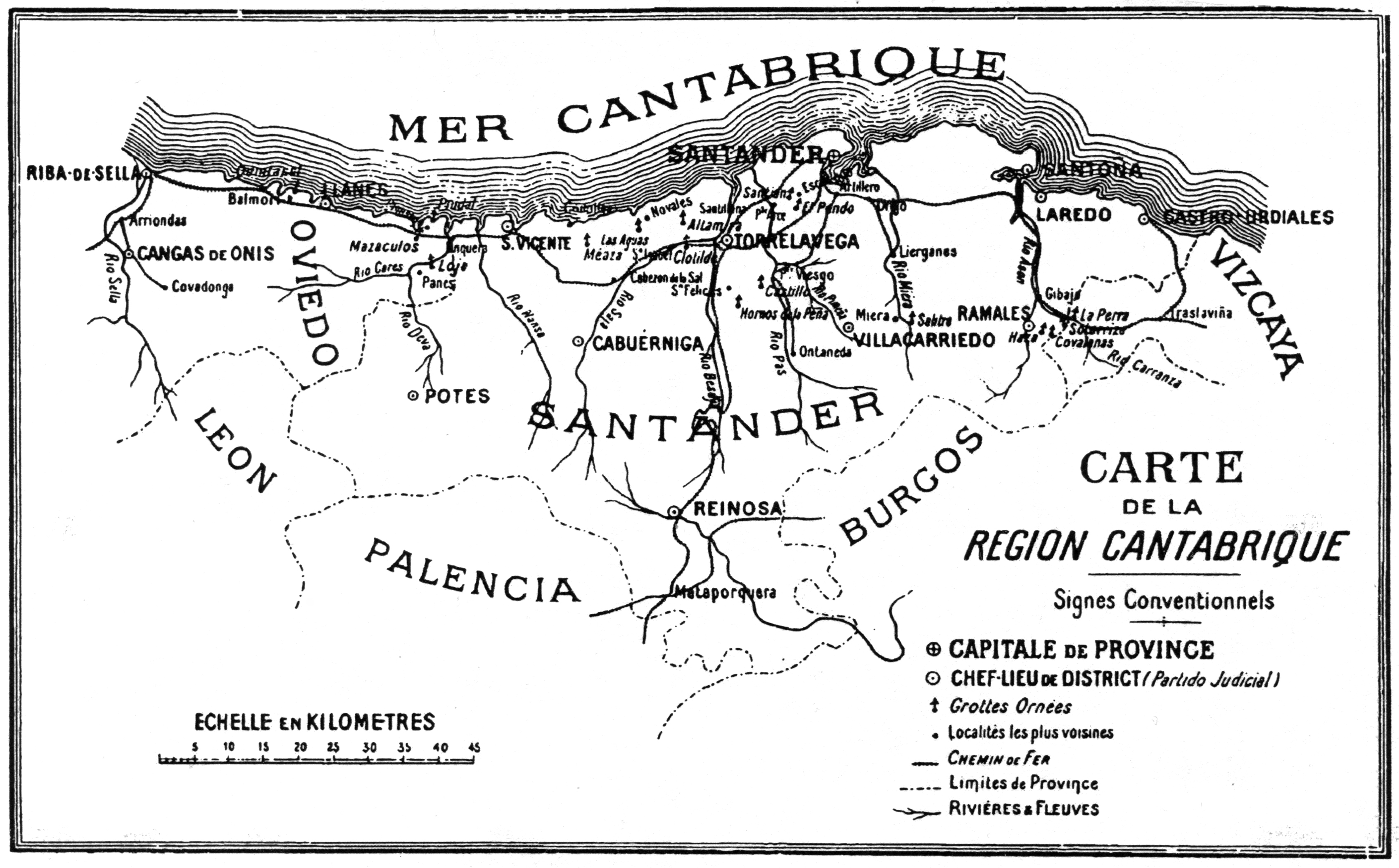
The caves of the Cantabria region, northern Spain
Les Cavernes de la Région Cantabrique (Espagne) by H. Alcalde del Rio, H. Breuil, R. Sierra
Translation by Don Hitchcock
Text, drawings, plans and maps, except where otherwise indicated, are from Alcalde del Rio et al. (1911)
The Caves of Cantabria
Chapter 1
The Caves of the Carranza Canyon
La Venta de la Perra - La Sotarriza.
When you travel by rail from Bilbao to Santander, shortly after the Villaverde de Trucios station, you can see, to the right of the track, and beyond a sharp foreground of gentle hills, a steep, white, bare massif of hard limestone. A few moments later, it appears, several more leagues away, cut by a deep gorge. The railway, after an immense loop, finally arrives at the Carranza station, then enters the gorge at the bottom of which, in places, there is not too much space for the Carranza river, the track railway and the main road.
To the right and left, the high limestone peaks stand desolate; to the right, the foot of the escarpment has a thousand holes with pointed openings; to the left, the foot of the slope rounds into a ridge where heather grows, and is overlooked by high peaks riddled with cave mouths.
This place had been noticed by MM. Cartailhac and Breuil, while passing on the railway, as early as 1902; they had planned to return there some day. The boundary of the two provinces of Biscay and Santander cuts the gorge crosswise, going down the steep ridge of the 'Salto del Pollo', between the village of Gibaja (Santander) and the Thermal Baths of Molinar (Biscay). Towards Gibaja station, the gorge does not take long to suddenly widen into a plain where the Rio Carranza joins its waters with those of the Rio Asón, descending from Ramalés.
Despite its numerous cavities, the Carranza defile only contains two or three with wall drawings; these are the Venta de la Perra, on the right bank, the Sotarriza and, perhaps, the Cova Negra, on the left bank.
I. The Venta de la Perra
Very close to the territorial marker, which, on the road from Santander to Bilbao, defines the two provinces, and on the Basque side, there is a poor hamlet of four houses: it is the 'Venta de la Perra', 'the Auberge de la Chienne', or 'the Inn of the female dog'.
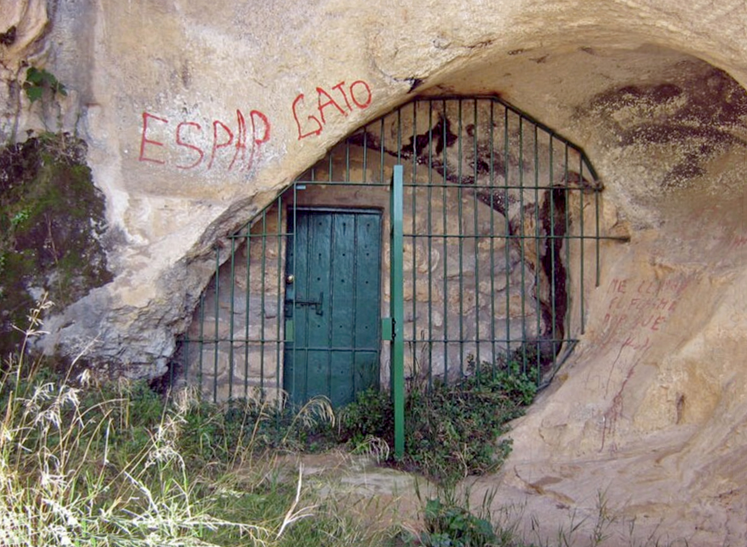
Just opposite, some fifty metres away, a spur juts out from the foot of the mountain, pierced by a triple opening of caves. To access it, you first cross a gentle cultivated slope, then brush growing in the fallen stones. ( The cave of the third opening is not described in the text - Don )
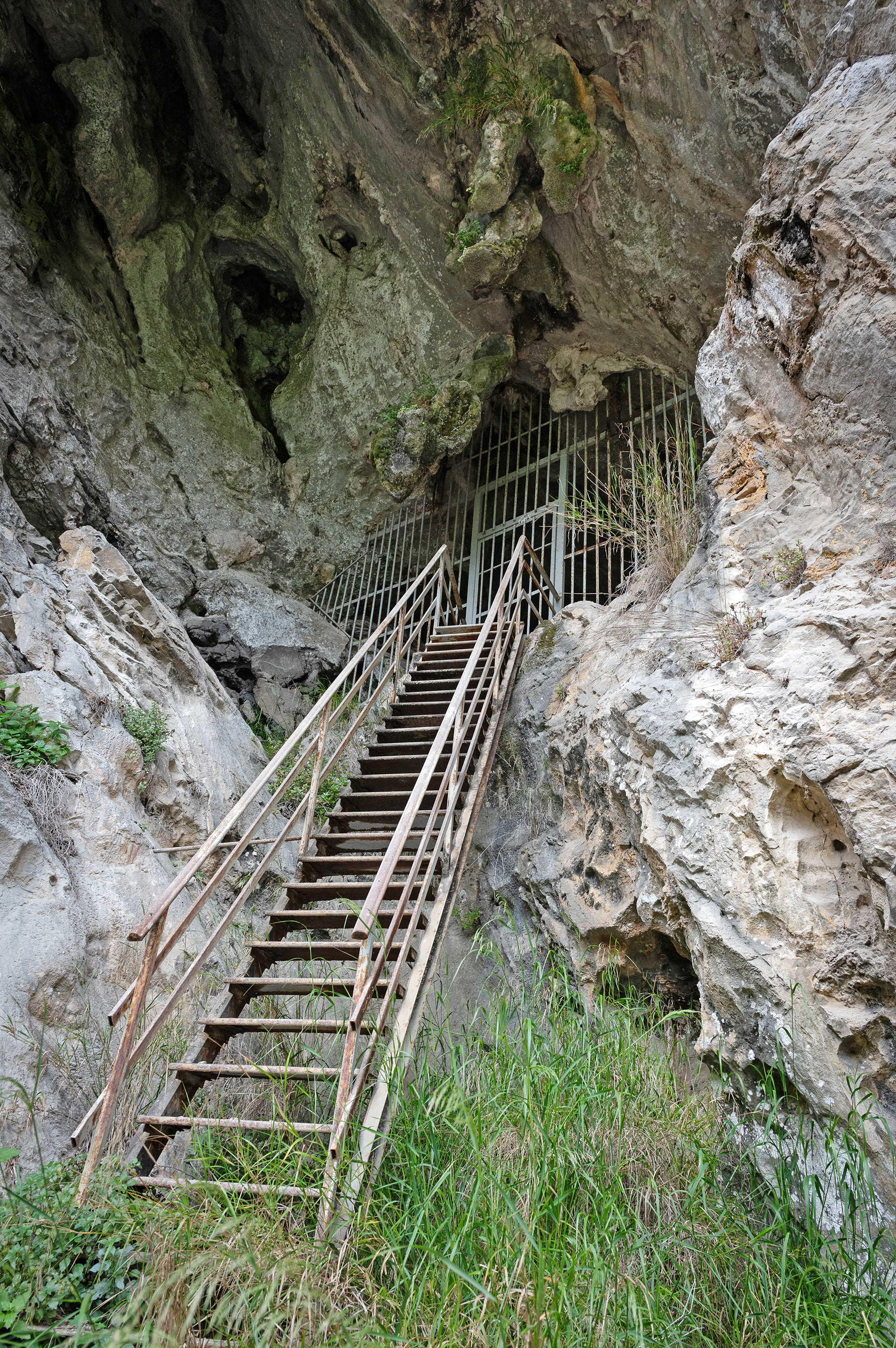
Entrance to the cave of la Venta de la Perra.
Photo: Thilo Parg / Wikimedia Commons
Permission: License: Creative Commons Attribution - ShareAlike 4.0 International
Proximal Source: Wikimedia Commons
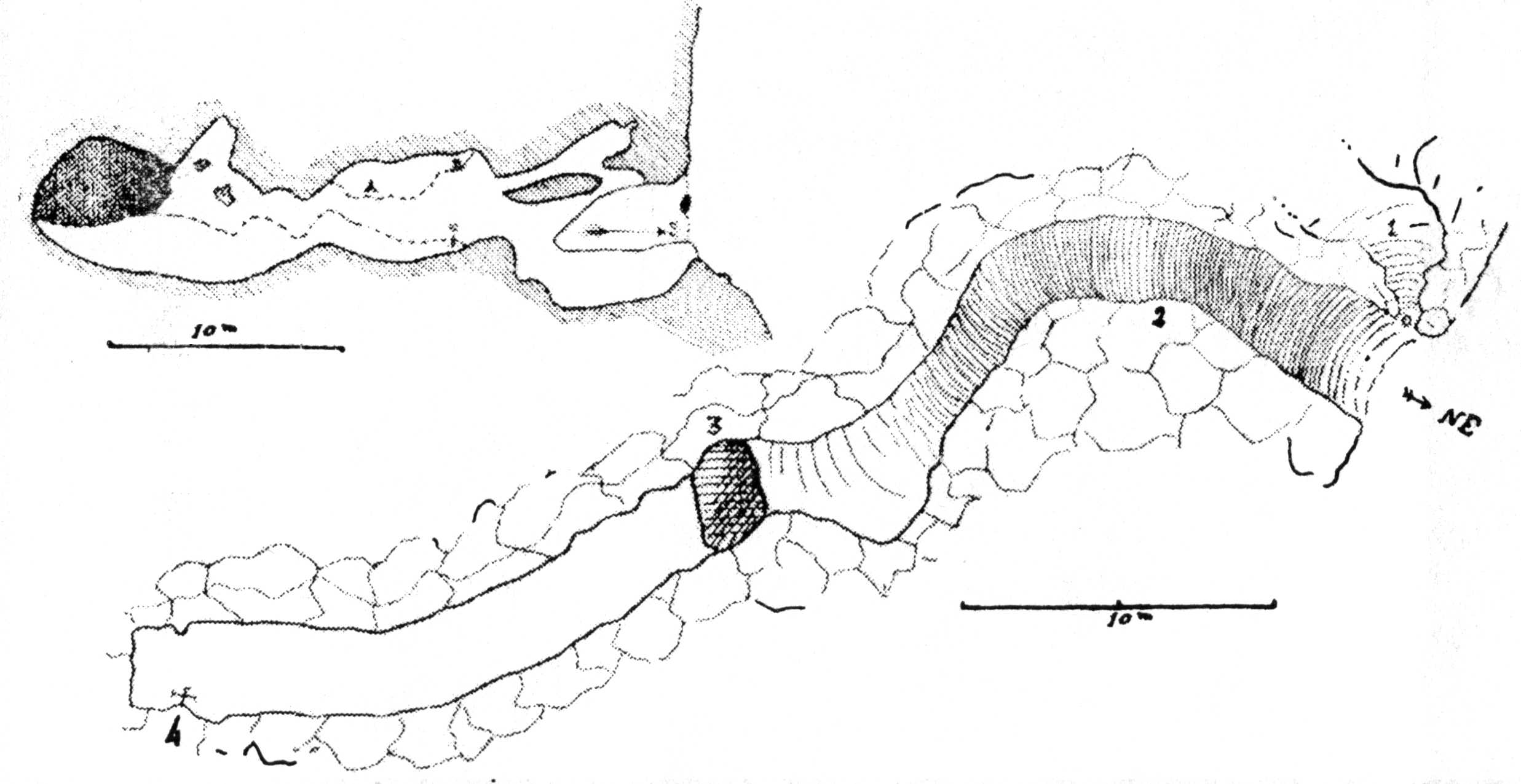
Figure 2
Plans of the caves of la Venta de la Perra (above and to the left), and la Sotarriza (larger, below).
( There are two cave entrances described at the site of la Venta de la Perra in the text - Don )
The one furthest to the left ( not shown on the plan - Don ) is accessible at ground level. At the entrance we see the remains of a ruined wall, resting on hardened clay, full of bone fragments, sandstone, and cut flint. About twenty metres towards the interior, under a thick stalagmite floor, we still see an archaeological foundation from the Palaeolithic period.
On each side of the gallery, the walls are bordered by large embankments where it is easy to climb up. On the left, on the rocky edge of stalagmite floor, we can still see an archaeological foundation from the Palaeolithic period. The cave continues for forty metres; but all its walls are corroded by very active condensation. Perhaps there were originally traces of old, vanished engravings, but nothing of them remains.
To the right of this cave, but in Biscay, although they are contiguous, is a second one (fig. 2, no. 1), with a steeper approach. You can easily access the vestibule located below, but it is only by climbing rocky crevices, not without effort, that you may gain the upper room, approximately four metres above the vestibule. It forms a fairly spacious cavity, well ventilated and well sheltered, which goats love today. It ends with a fairly wide, but shallow shaft, which must end at the level of the first cave, perhaps at its filled end.
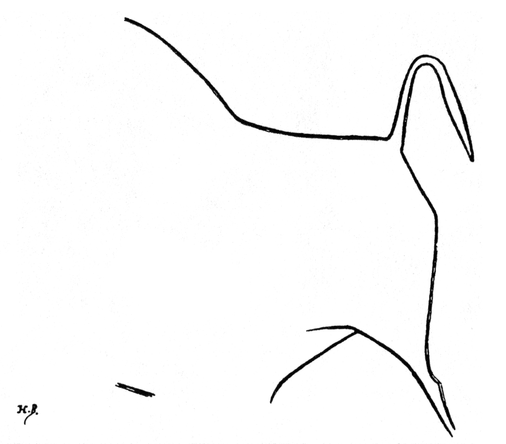
Figure 3
Hind quarters of a bison from la Venta de la Perra, located at C on the plan.
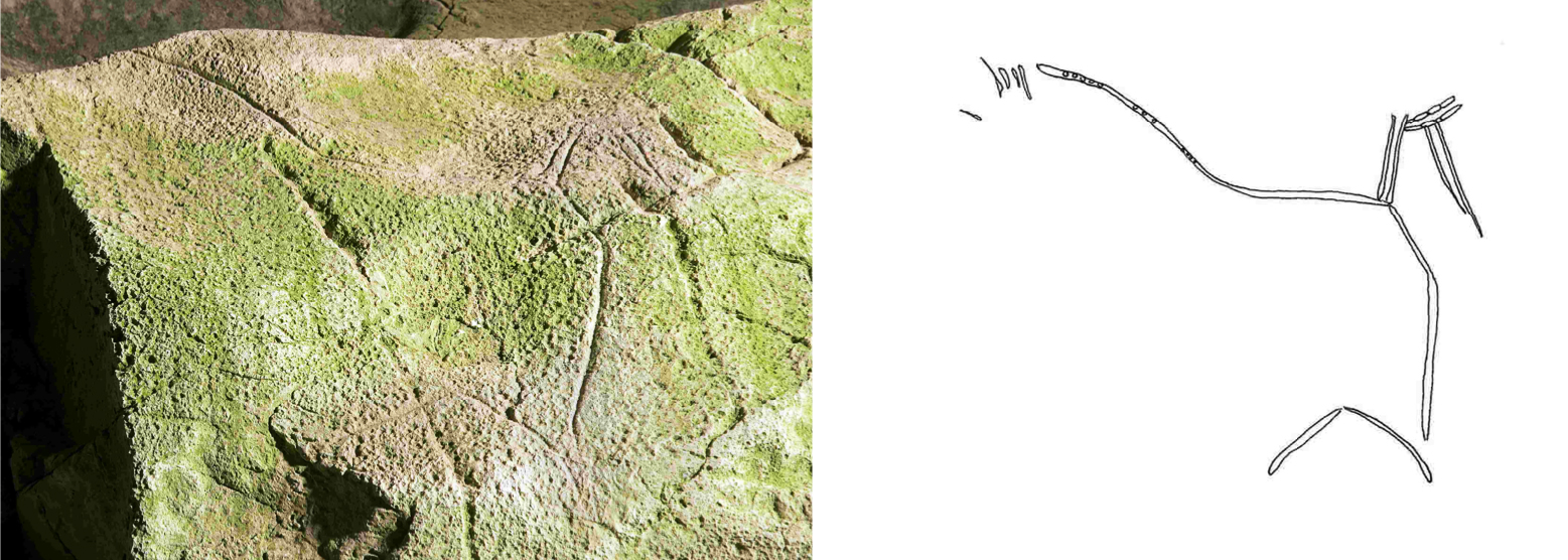
Figure and tracing of a bison from Venta de la Perra.
Marks from percussion may be seen in the dorsal arch and in the horizontal sections of the tail.
Photo, drawing and text: Idarraga (2011)
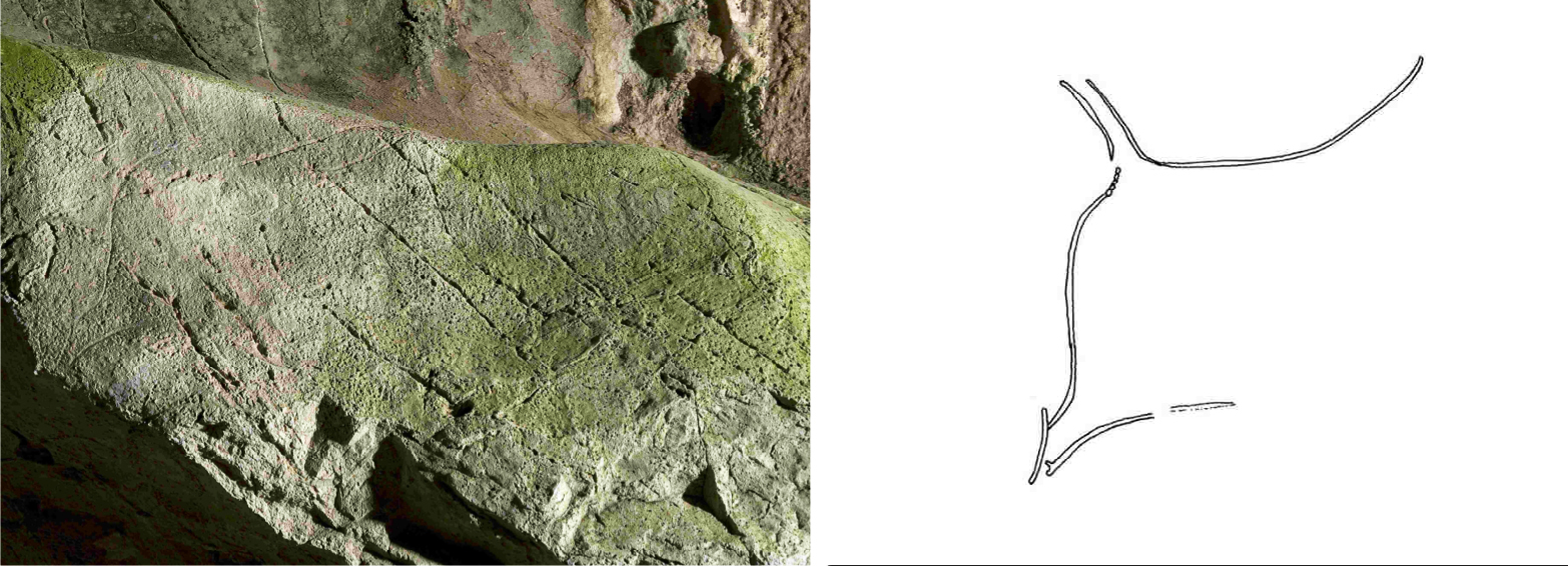
Figure and tracing of a bison. The animal's leg shows the hock.
Photo, drawing and text: Idarraga (2011)
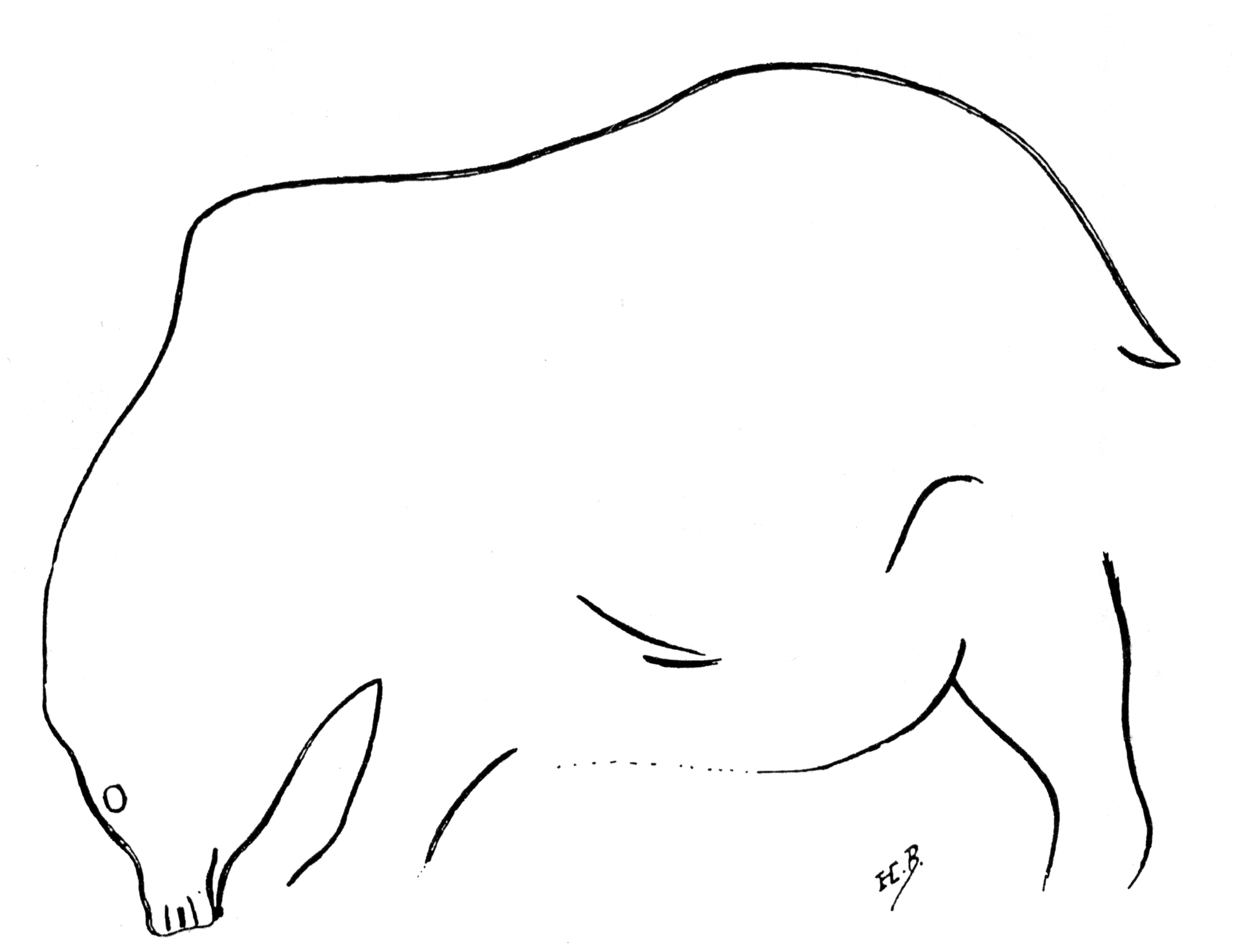
Figure 4
Bear engraving from la Venta de la Perra, located at A on the plan. Width 85 cm.
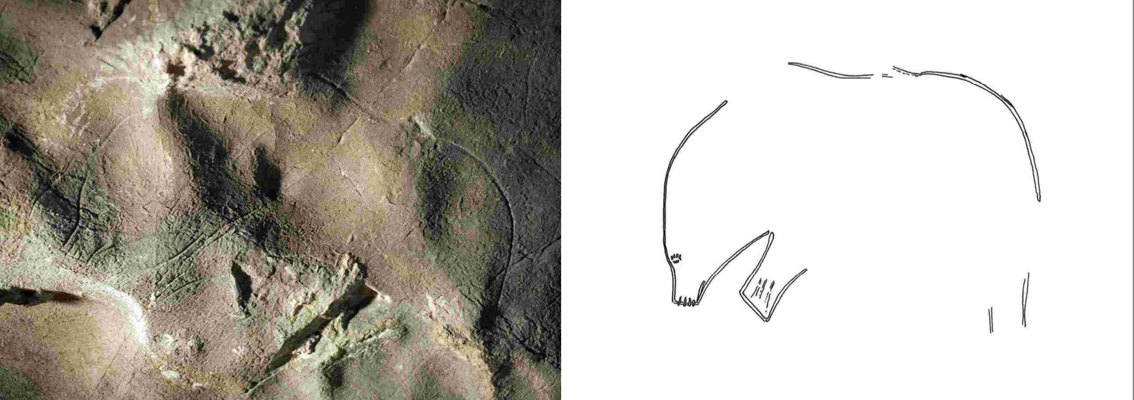
Bear figure and tracing. The eye and tail are made by means of percussion without further engraving.
Photo, drawing and text: Idarraga (2011)
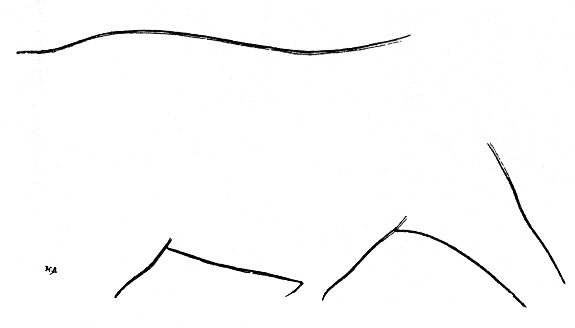
Figure 5
Bovid engraving from la Venta de la Perra, located at A on the plan. Width 75 cm.
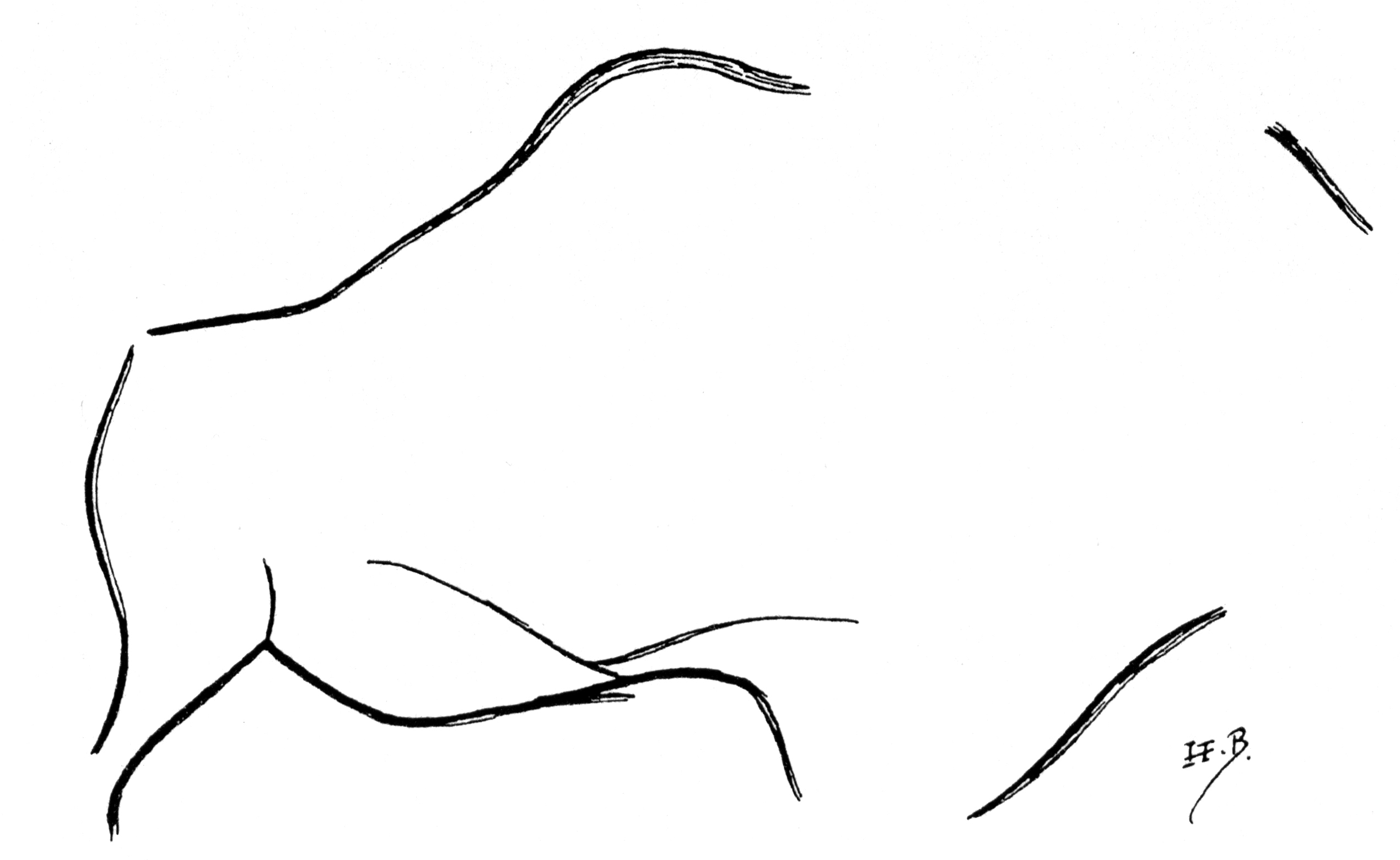
Figure 6
Bison engraving from la Venta de la Perra, located at B on the plan.
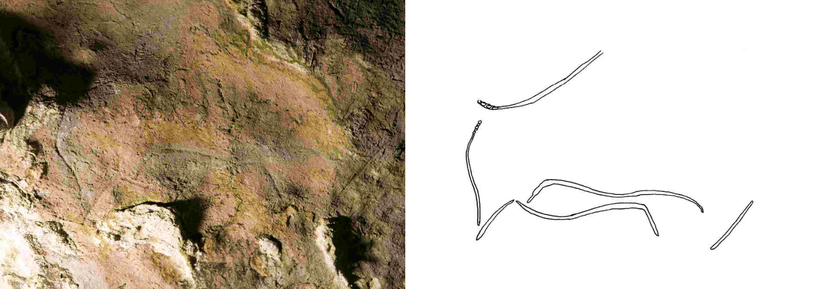
Figure and tracing of a bison.
Photo, drawing and text: Idarraga (2011)
On each side of the gallery, the walls are bordered by large embankments where it is easy to climb up. On the left, on the rocky edge of one of them, we see a deeply engraved drawing showing the hindquarters of a Bison (in C of the plan) galloping, its tail straightened like a shepherd's crook (fig. 3). The outline of the engraving is clean, vigorous, and of the same colour as the surrounding surfaces. No artificial light is necessary to see it. Unfortunately, the rock where the head and the forequarters had been painted has collapsed.
Instead of rising almost vertically, the wall which faces the previous design forms within reach of the hand a large ceiling surface. Numerous rather faded lines crisscross it, but we must give up on identifying them all.
Only three figures are decipherable; These are, going from the shaft to the exit: a Bear (fig. 4), very recognisable, lowering its head as if sniffing the ground; it does not present the very convex forehead typical of the Cave Bear; - then an animal body which appears to be that of a bovid (fig. 5); - finally, another Bison, whose head is not legible (fig. 6).
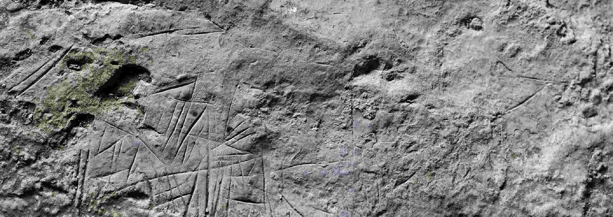
Finally, if we continue walking along the narrow cornice continuing the floor of the same room, on the left side going towards daylight, we notice a horizontal surface belonging to the cornice itself, completely cut with multiple incisions. intersecting in all directions (fig. 7).
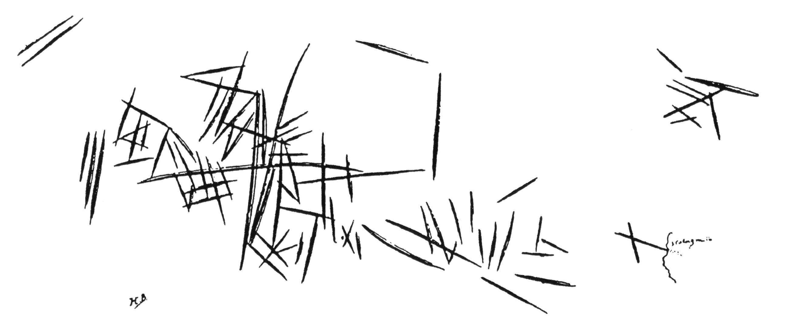
Figure 7
Incisions made on a rock entablature to the right of the vestibule of Venta de la Perra.
Width: 35 cm
Deep incisions in a horizontal ledge on the outside of the vestibule of Venta de la Perra.
Photo and text: Idarraga (2011)
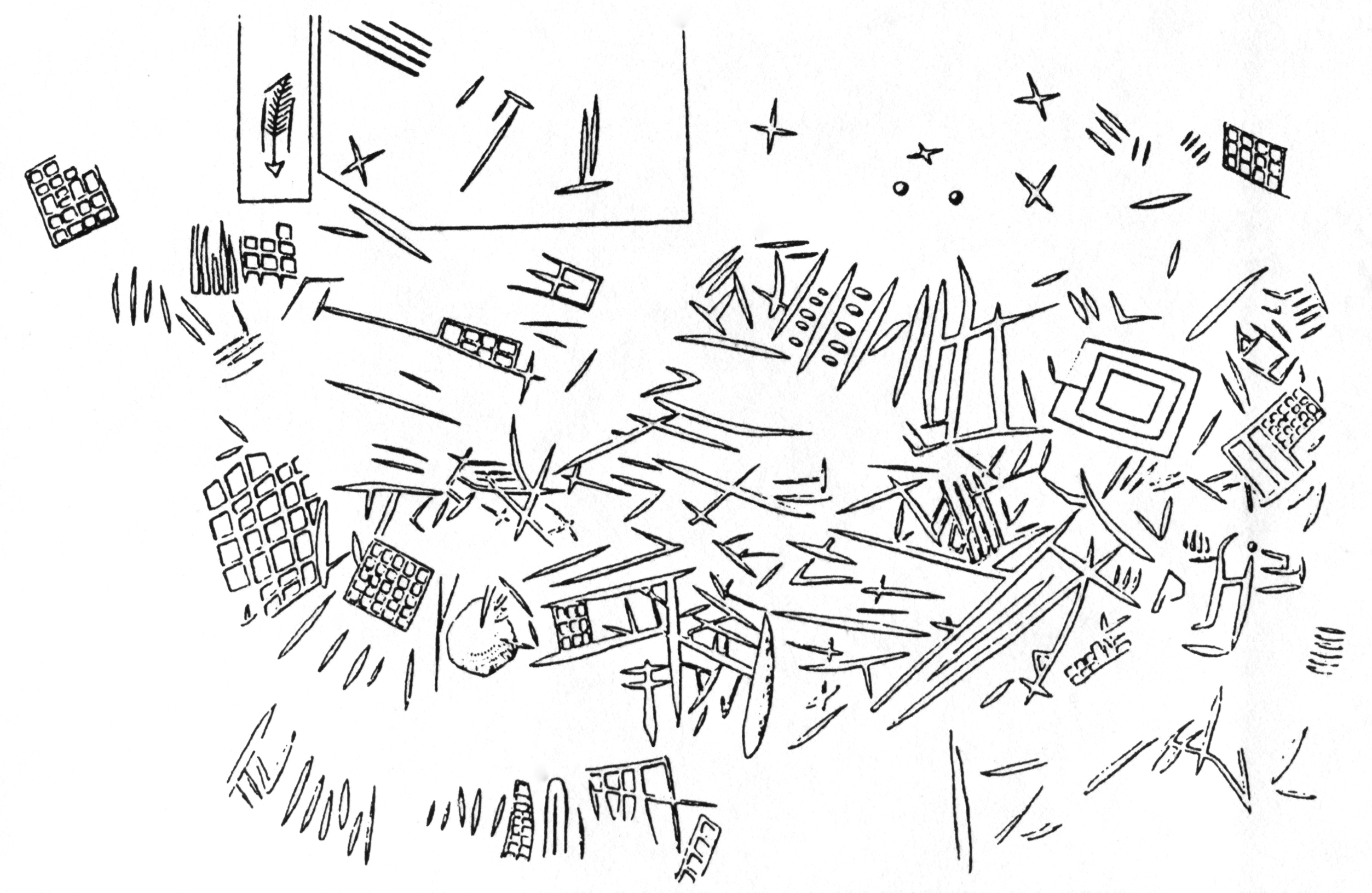
Figure 8
Incisions on sandstone rocks of Seine and Marne, according to G. Courty. They recall, with a few more complications, the incisions of fig. 7, discovered at Venta de la Perra.
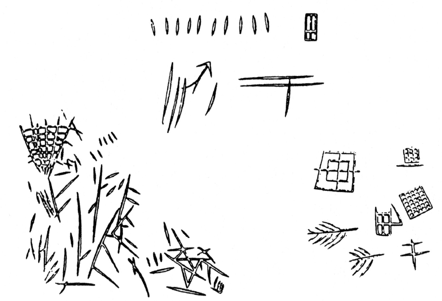
Figure 9
Incisions on sandstone rocks of Seine et Marne, according to G. Courty, reminiscent of those from Venta de la Perra.
We can hardly compare these singular engravings, certainly very old, as demonstrated by their great deterioration and the dry concretions which partially cover them, to petroglyphs discovered in the Fontainebleau region by M. Courty (fig. 8). The latter are not dated with certainty, and nothing says that their age is not older than the Neolithic era, dubiously insinuated by their discoverer.
Conversely, we have no evidence that the marks in the Spanish cave relate to the same age as the neighbouring zoomorphic drawings; They could very well be younger, although we don't think so.
In any case, no specifically Neolithic figures are found in the petroglyphs of Etampes; the feathered features are found in Quaternary art, and the checkerboards and quadrilaterals seem to result from the processes used by the engraver.
It does not seem, in fact, that sandstone lends itself to receiving freehand engravings like a soft limestone rock; all we can do, unless we proceed by pecking, is to dig rectilinear incisions and group them into very simple figures.
The animal engravings from Venta de la Perra can only be dated by their style. It will not tell us much to know that the remains of a rather crude upper Palaeolithic were collected in the same cavity and in those in the vicinity; there are also shards of Neolithic pottery and vestiges of all ages. It is more instructive to note the very archaic style of the silhouettes: a definite profile is the rule, the extremities are neglected, and only one leg of each pair is indicated; the line, to have survived, must have been deeply dug.
Through all these characteristics, the images of the Venta de la Perra are similar to the Aurignacian figures of the Pair-Non-Pair cave, and must probably be attributed to this first phase of the Upper Palaeolithic.
II - La Sotarriza
Opposite the Venta de la Perra, the caves that can be seen, explored by Father Sierra, have revealed nothing.
Two others had some interesting facts in store for him; They are almost hidden at the top of the rounded hillock which dominates the river, and it is impossible to see them before arriving at their low, wide entrance.
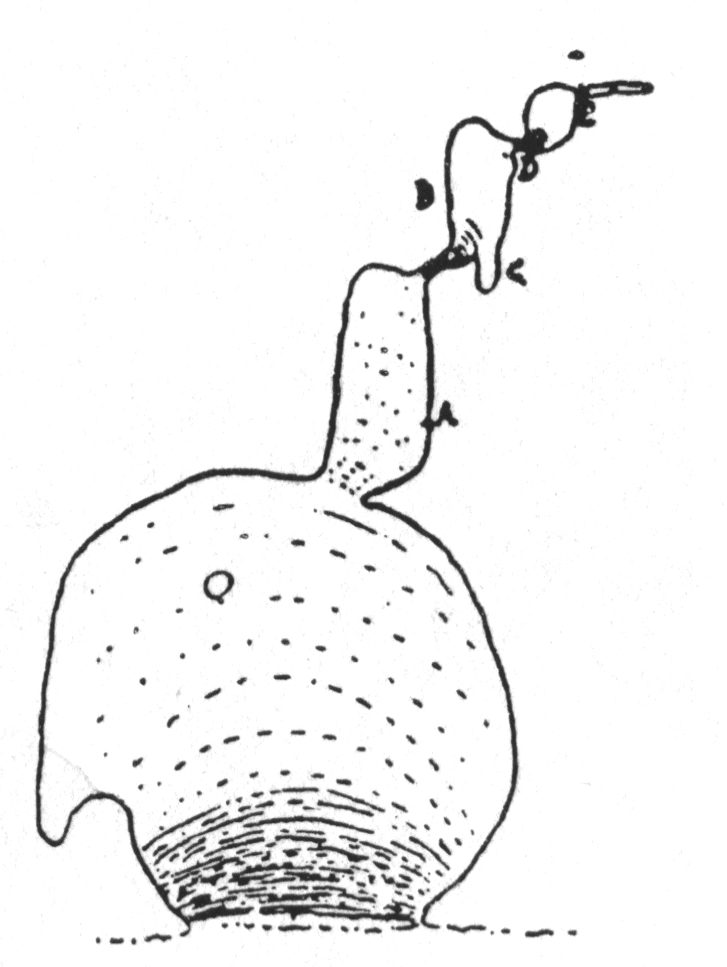
Figure 10
The first, called Cova Negra, begins with a pretty, round, spacious room, decorated with well formed columns, with a thick floor sloping steeply towards the interior.
Towards the back, on the right, opens a fairly wide corridor, whose right-hand wall reveals a few poorly preserved black marks, the remains of some ancient parietal ornamentation. We first notice a sort of V lying on the right side, then a little later, an isolated, slightly oblique black line. At the end of this corridor, which is around twenty metres long, a very low passage opens, sloping steeply, leading, after three metres, to a third room, a little less spacious than the second.
The walls are admirably conserved surfaces plowed by the claws of the great Bear; the left wall (B of the plan) is especially remarkable, and completely recalls that of Bétharram (Hautes-Pyrénées) which was published with the approval of its discoverer, Mr. Cartailhac, by MM. Capitan and Breuil.
In a corner located to the right, the remains are of a slightly different nature; these are terrifying furrows, of astonishing depth, which have plowed the red clay of the soil, which today are compact and dried out.
Several of these prints, when measured, denote a gap of 20 cm between the extreme claws of the same paw. The Great Bear did even better: burrowing like a badger, he excavated (D of the plan) a narrow slit from the clay which filled it, to enter a small cramped rotunda. At the entrance to this kind of trench which he opened, the prints of his paws are truly marvellously preserved. Traces continue to be observed on the ground and walls up to the first metres of a very narrow final passage where the bear could not enter. Traces suddenly disappear.
La Cova Negra is yet another cave that has preserved the remains of the great cave bears. In our volume on Font-de-Gaume, the subject was sufficiently examined for us not to dwell on it further here.
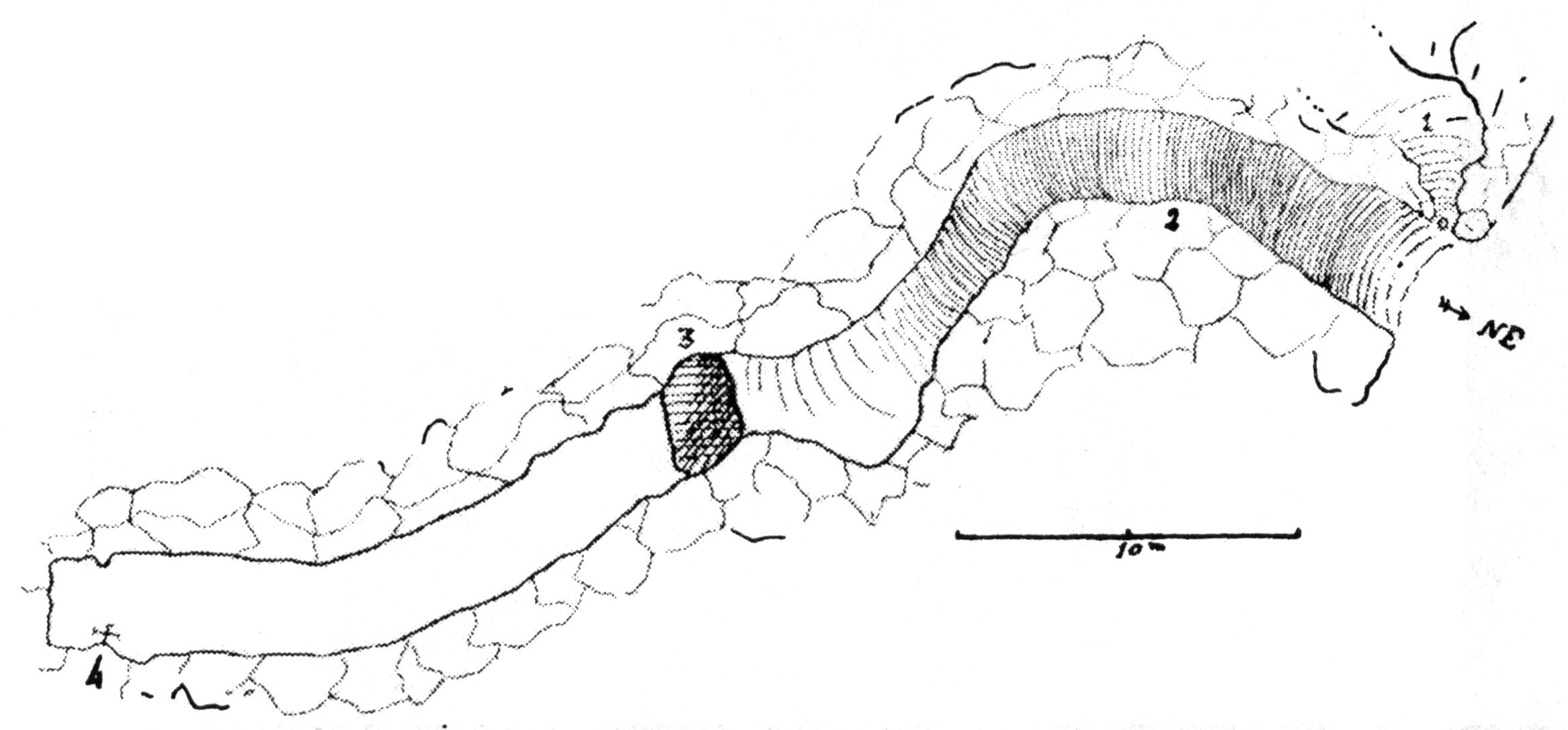
Figure 2
Plan of the cave la Sotarriza.
The entrance to Sotarriza, a little lower than that of Cova Negra, gives access to two very large galleries. The first opens to the right, almost on the threshold, through a narrow constriction between several stalagmitic columns; it seems to be in the process of collapsing, if we judge by the immense slabs fallen one on top of the other. It does not offer anything interesting.
The main gallery continues at the entrance: the ceiling remains substantially horizontal, but the floor literally moves under the feet via a mobile stony slope at around 45°, which leads you 30 metres down to a less oblique but extremely slippery slope of clay-stalagmite convexities.
Soon the ground becomes level, but you are stopped by a 170 cm-deep, 3 metre wide, sheer-walled pot hole which stretches from one side of the passage to the other, which you can't easily cross without help.
( Potholes are eroded by water in the bed of a stream carrying sand, pebbles and even larger stones, which abrade the rocky bed by the swirling action of the water - Don )
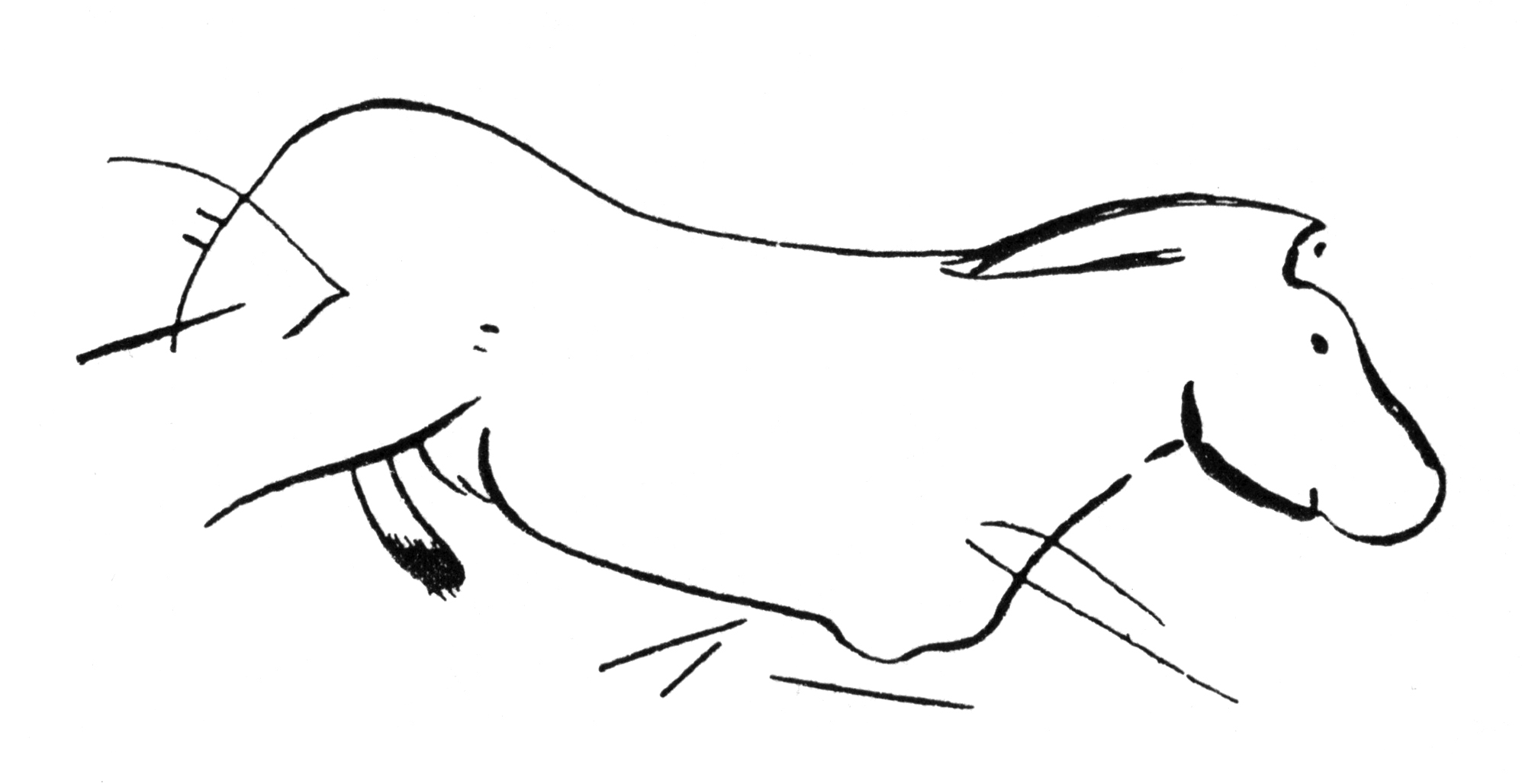
Figure 11
Black horse from la Sotarriza.
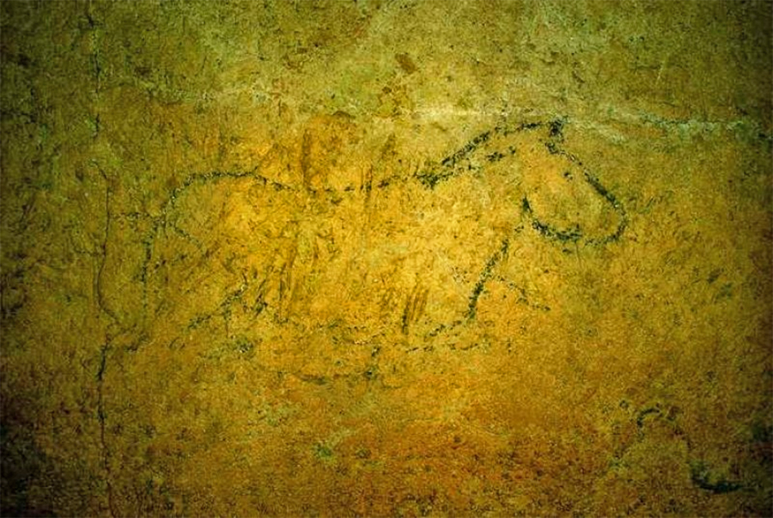
Black horse from la Sotarriza.
Source: www.cantabriatotal.com
Beyond that, there are no obstacles, and we continue exploring on an always slippery floor, strewn with encrusting basins filled with pisoliths.
( Ooids (sometimes called ooliths) are sand-sized grains (less than 2mm in diameter) consisting of one or more layers of calcite or aragonite around a central quartz grain or carbonate mineral fragment. These likely form by direct precipitation of calcium carbonate onto the ooid. Pisoliths are similar to ooids, but they are larger than 2 mm in diameter and tend to be more irregular in shape. Limestone composed mostly of ooids is called an oolite or sometimes an oolitic limestone, such as was used for the Venus of Willendorf - Don )
Up to the last metre of this strange underground passage, no vestige of artwork can be seen, except for, at eye level, a small black horse, very crude, quickly traced by a Palaeolithic artist (fig. 11). It belongs to the group of small animals of the same colour, so common in Altamira and Castillo.
What motive pushed the Quaternary artist to go all the way to the back of this inhospitable gallery, to trace this isolated sketch? Does it mean anything other than the mark of his exceptional passage, and like the graffiti of his name, left there, as a testimony to his boldness? We will never know.
The Caves of Cantabria
Chapter II
The Ramalès caves - La Haza - Covalanas
When, from Gibaja, we go up, towards the South West, along the beautiful valley of the Rio Asón, after 4 kilometres we arrive at Ramalès, a large town surrounded by high peaks, among which the Pico San Vicente stands out. We are here on the southern flank of the massif located South West of the Carranza gorge, the other side of which allowed us to study the Cova Negra and the Sotarriza.
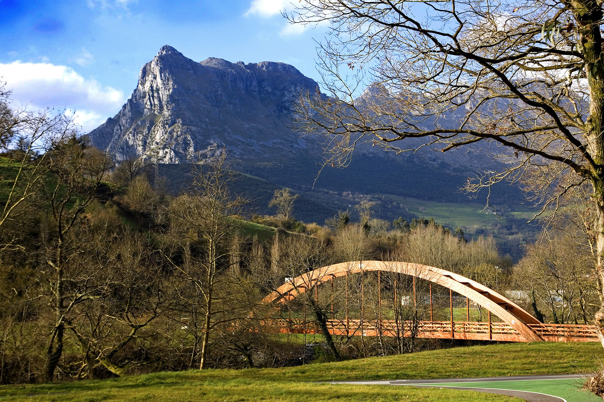
Pico de San Vicente and a wooden bridge over the Asón river.
Photo: Unersis
Permission: Creative Commons Attribution-Share Alike 4.0 International license.
Proximal source: Wikipedia
A torrent, the Rio de la Calera, joins the main valley on the right bank, and descends via Lanestosa (Biscaya) from the heights of Mount Ocejo. Going up its valley by the road which leads to the Basque village, we cross, barely two kilometres from Ramalès, a large rocky cirque, jagged in its middle by a steep pass. The torrent does not flow there, but for a few hundred metres, it enters cracks and follows an underground course.
During heavy rains, we can see water rushing into it, into a sort of cave, and emerge on the side of the ravine. The current road makes a thousand bends on the gentler slopes which face the cirque, while the steep walls of the latter are climbed by an ancient 'carrettera' ( road - Don ).
In the part closest to Ramalès, beyond the limits of the cirque itself, an immense cavern opens at the level of the lowest part of the valley, behind groves of holm oaks. Several kilometres long, still incompletely explored, it has preserved no other vestiges of ancient occupation other than a few scraps of a deposit that the winter stream has moved around.
A pretty eyed needle was collected there by M. Alcalde del Rio. A little above, there is another cave inhabited since the Palaeolithic and during later periods, Costàles, whose deposit, largely emptied, is filled with Helix shells.
But let's get closer to the bottom of the cirque following the old 'carrettera'. It does not take long to pass under a first group of small caves which bear the name of la Haza; it is the last of them which contains the frescoes discovered in 1903.
Then, towards the bottom of the cirque, some fifty metres above the path, we see a vast opening which extends into a rising gallery partly filled with river pebbles brought by the torrent in a period prior to the digging of its valley and gorge.
This cave, called Miron, was only occupied towards the entrance; important Palaeolithic deposits occupy the well ventilated and dry vestibule; they have been much altered since, as a result of the Carlists ( an ultra-conservative popular political movement in Spain - Don ) having fortified the cave, and having defended it against General Espartero; they even installed a cannon there.
The dark galleries further in are devoid of any wall decoration, and there is extraordinary condensation there during the summer.
Far above, at approximately 80 metres above the pass, and on the same vertical as Miron, a gigantic ivy can be seen; it indicates the entrance to the Covalanas cave.
It can hardly be accessed from Miron; at least the climb could end in a serious accident. It is simpler to continue the old 'carrettera' until the pass, where it crosses the ravine on a small bridge and joins the new road.
Instead of crossing the bridge, you have to follow a goat track, and, from rock to rock, climb with difficulty to the ledge where the cave opens.
On the other side of the pass, there is, either in the same rocky promontory, but on the southern side, or at the foot of the immense vertical wall that we discover on the left, a series of other caverns; several have been occupied since the Palaeolithic era, but none present any wall decorations. Let us return to the two caves which do contain them.
I - La Haza
Entrance to La Haza cave
Photo: Edward the Confessor
Permission: CC-BY-SA 4.0
Proximal source: mapcarta.com/N861256763
La Haza cave (fig. 12) consists of a very wide open vestibule, with a steep slope towards the road located 10 or 15 metres lower, and two rooms to which it accesses: a small one, on the right, without no trace of occupancy, provided with a large window overlooking the valley; another, a very low entrance that can only be crossed on one's knees.
In the vestibule, a few scraps of breccia attest that an archaeological deposit once existed there; we collected several flints there. The deposit seems to have completely filled the opening, which shepherds undoubtedly cleared to take shelter with their livestock. It also seems that the earth was extracted for fertiliser and left the stones, which roll abundantly inside. There are numerous pebbles that served as anvils; the flints, rare, are of fairly primitive forms which exclude the Magdalenian.
The room is approximately round, higher on the right than on the left, where there are many stalactites; in the middle are several columns of the same nature.
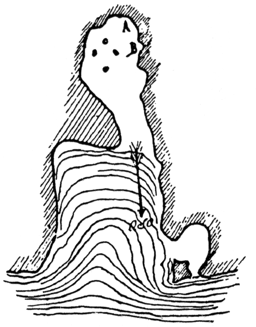
Figure 12
Plan of La Haza.
Drawn by P. Sierra
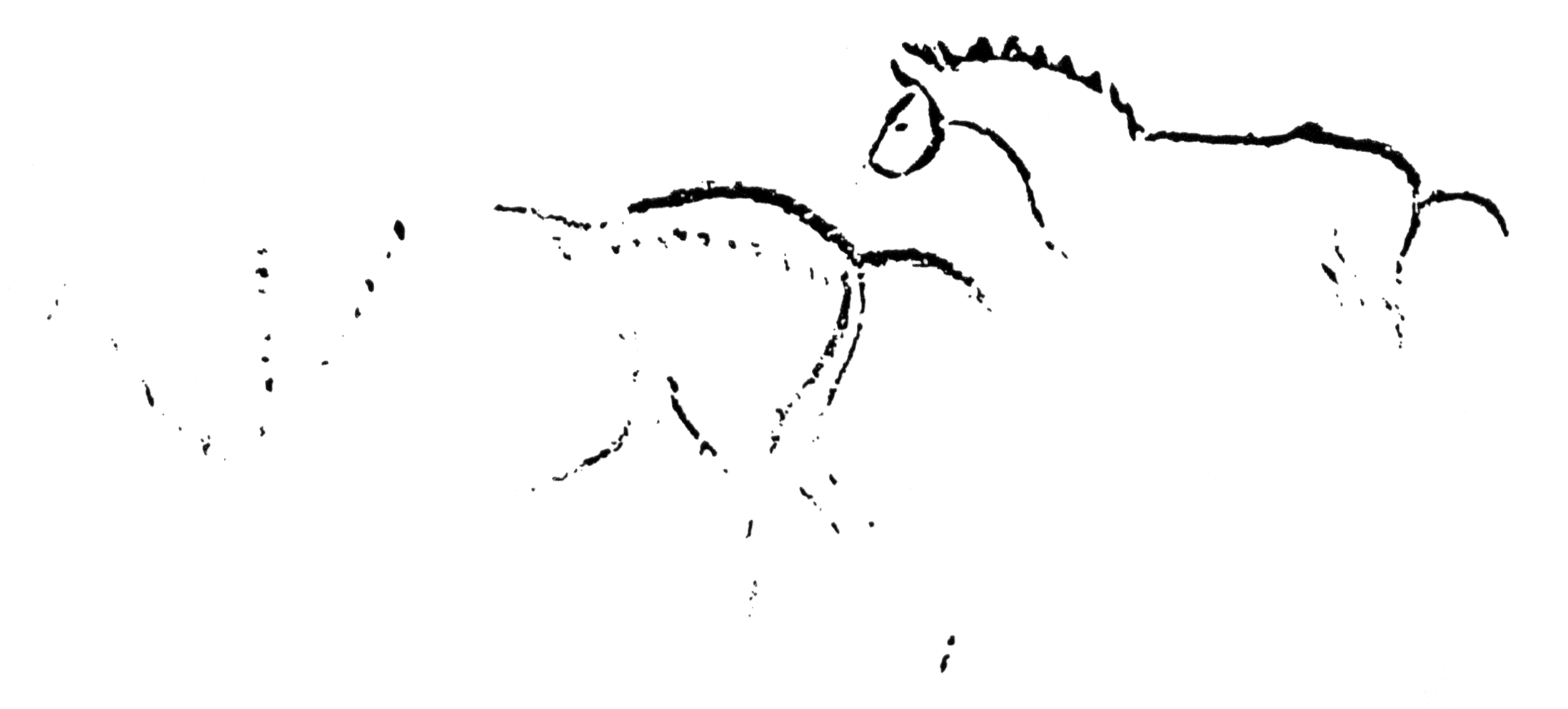
Figure 13
Red horses from La Haza, situated at A on the plan.
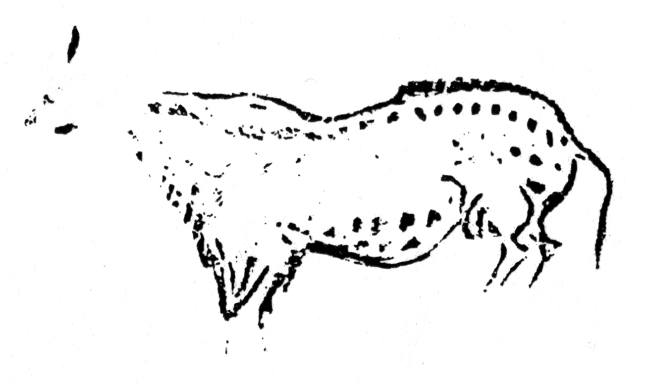
Figure 14
Spotted horse from La Haza, situated at A on the plan, but lower than those shown in Figure 13.
References
- Alcalde del Rio H., Breuil H., Sierra L., 1911: Les Cavernes de la Région Cantabrique (Espagne), Planches et figures par l'abbé H. Breuil, published under the auspices of Prince Albert of Monaco.
- Idarraga R., 2011: Una mirada al arte decorativo de la edad de piedra, ISBN : 978-84-7752-451-3
Back to Don's Maps
Back to Archaeological Sites