Back to Don's Maps
 Back to Archaeological Sites
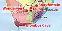 Hominid sites in Africa, including Homo sapiens
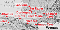 Hominid sites in Europe, including Homo sapiens
Hominid sites in Europe and nearby regions
Hominids or Hominins?
The most commonly used recent definitions are:
Hominid – the group consisting of all modern and extinct Great Apes (that is, modern humans, chimpanzees, gorillas and orang-utans plus all their immediate ancestors).
Hominin – the group consisting of modern humans, extinct human species and all our immediate ancestors (including members of the genera Homo, Australopithecus, Paranthropus and Ardipithecus).
Definition above: https://australianmuseum.net.au/
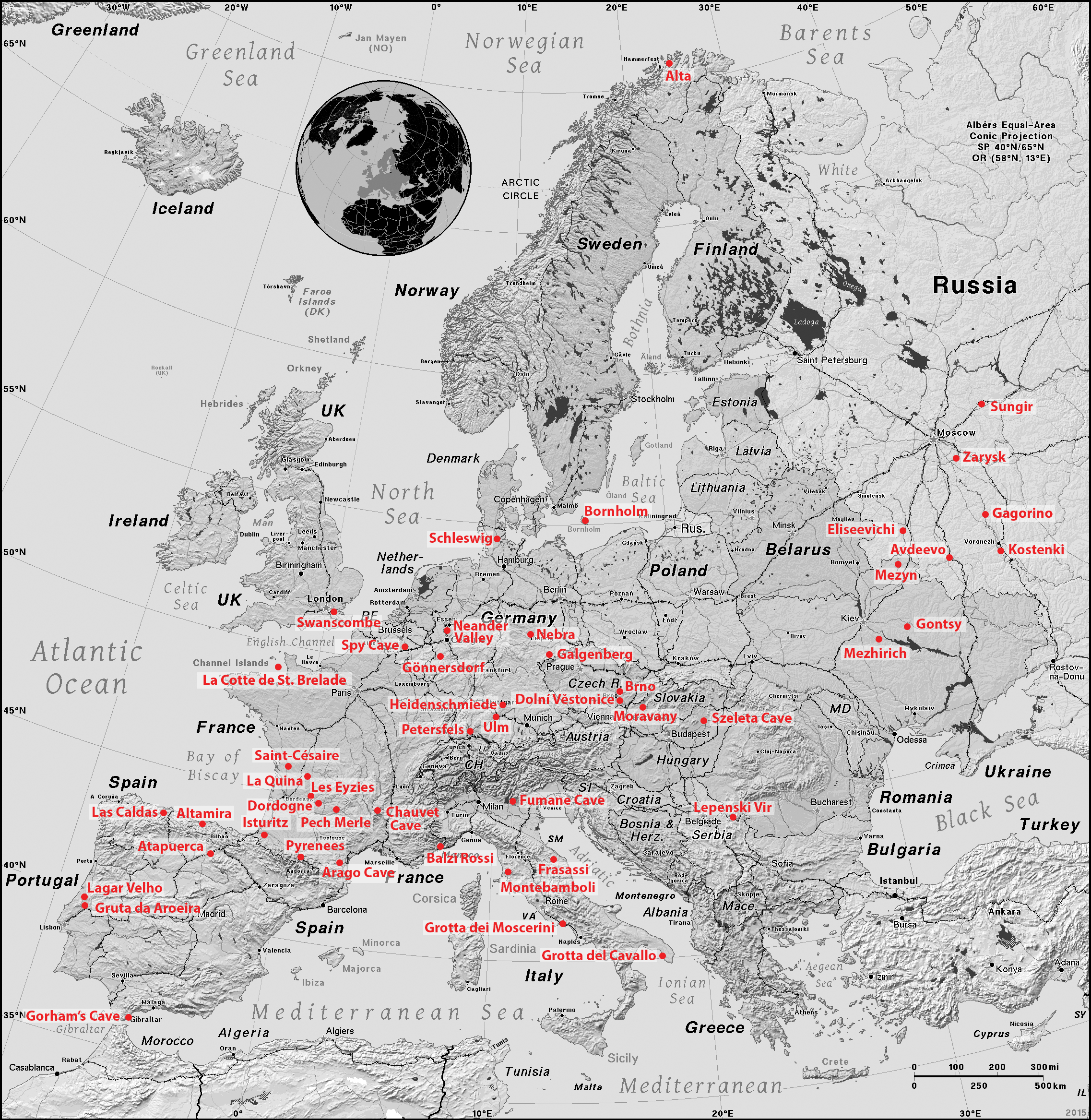
Map of important Hominid sites in Europe and nearby regions.
Click on the map to obtain the high resolution version.
Base Map: https://ian.macky.net/pat/map/euro/euro.html
Permission: ![]() This work has been released into the public domain
This work has been released into the public domain
Additional text in red: Don Hitchcock
| Important Hominin sites in Europe and nearby regions | |||
|---|---|---|---|
| Map Reference | Comment | Linked Image | Text and Link |
| Alta |
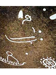
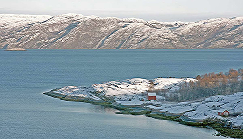 The rock drawings of Alta constitute the most important piece of evidence in favour of the existence of human activity in the confines of the Great North during the prehistoric period. Studied from 1967, the petroglyphs of the Alta fjord in the province of Tromsø were immediately classed among the leading rock art sites in the world. Close to the Arctic Circle, they are a valuable illustration of human activity between 6 200 and 2 500 BP in the Northern Hemisphere. They are primordial evidence of the fauna, representing reindeer, elks, bears, dogs and/or wolves, foxes, hares, geese, ducks, swans, cormorants, halibut, salmon and whales, and of the environment. They also depict boating, hunting, trapping and fishing scenes, as well as people taking part in dances and ritual acts. In the final phase, some agricultural activities, rendered precarious by the climate, appear to have supplemented certain staples traditionally provided by hunting and fishing. |

|
The thousands of paintings and engravings located at 45 sites scattered over seven localities illustrate a chronological sequence consisting of four phases. The largest area is at Hjemmeluft/Jiepmaluokta, where Alta Museum is situated. Approximately 3 000 figures have been found here. This is the only area open to the public. In addition, there is an area with rock paintings. Some of the panels at Hjemmeluft/Jiepmaluokta are linked by wooden footways.
Hunters and fishers in the late Stone Age/early Metal Age, between 6 200 and 2 000 years ago, made the rock carvings in Alta. During this period, Hjemmeluft/Jiepmaluokta was where people from the coast and inland regions, who gathered here several times a year perhaps in connection with seasonal, nomadic journeys, performed ritual ceremonies. The rock carvings depict some of the beliefs held by these people and the rites they practised. The rock carvings were probably elements in myths and stories about the worlds inhabited by the people and the spirits. See: Homo sapiens |
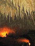
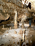
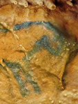
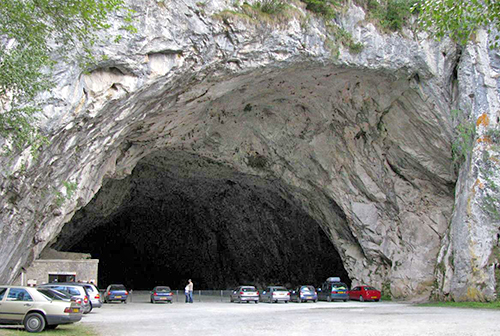
| Altamira |
 Altamira Cave is 270 metres long and consists of a series of twisting passages and chambers. The main passage varies from two to six metres in height. Archaeological excavations in the cave floor found rich deposits of artefacts from the Upper Solutrean (circa 18 500 years ago) and Lower Magdalenean (between circa 16 500 and 14 000 years ago). Both periods belong to the Palaeolithic or Old Stone Age. In the millennia between these two occupations, the cave was evidently inhabited only by wild animals. Human occupants of the site were well-positioned to take advantage of the rich wildlife that grazed in the valleys of the surrounding mountains as well as the marine life available in nearby coastal areas. Around 13 000 years ago a rockfall sealed the cave's entrance, preserving its contents until its eventual discovery, which occurred after a nearby tree fell and disturbed the fallen rocks. |
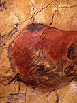
|
Human occupation was limited to the cave mouth, although paintings were created throughout the length of the cave. The artists used charcoal and ochre or haematite to create the images, often diluting these pigments to produce variations in intensity and creating an impression of chiaroscuro. They also exploited the natural contours in the cave walls to give their subjects a three-dimensional effect. The Polychrome Ceiling is the most impressive feature of the cave, depicting a herd of extinct Steppe Bison (Bison priscus) in different poses, two horses, a large doe, and possibly a wild boar.
See: Homo sapiens |
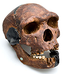
| Arago Cave |
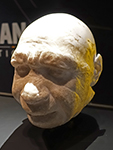
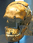
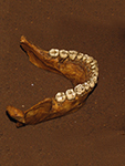
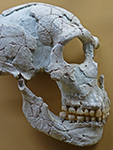
 Excavations since 1964 have revealed a number of human fossils at Arago including a skull and jaw from different individuals. Thousands of stone tools and the bones of many types of animals have also been uncovered at this site. The Arago 21 skull is relatively complete but it was distorted either before or during fossilisation. Its features are typical of this species but its size and robust facial features suggest that it is the skull of a young male whose age at death was circa 20 years old. It has been dated as being between 250 000 BP and 400 000 BP. |
|
Tautavel Man (Homo erectus tautavelensis), is a proposed subspecies of the hominin Homo erectus, the 450 000 years old fossil remains of whom were discovered in the Arago Cave in Tautavel, France. Excavations began in 1964, with the first notable discovery occurring in 1969. The skeletal remains of two individual hominins have been found in the cave: a female older than forty (Arago II, July 1969), and a male aged no more than twenty (Arago XXI, July 1971, and Arago XLVII, July 1979). Recovered stone tools originate from within a 5 kilometres radius of the cave, while animal bones suggest the inhabitants could travel up to 33 kilometres for food. See: Homo erectus tautavelensis |
|
Homo heidelbergensis - Arago 21 and Arago, a skull and lower jaw of Homo heidelbergensis were discovered in Arago Caves, Tautavel, France. Excavations since 1964 have revealed a number of human fossils at Arago, as well as thousands of stone tools. The bones of many types of animals have also been uncovered at this site.
See: Homo heidelbergensis |
||
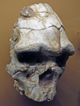
| Atapuerca |
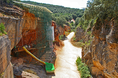 Fossils from the Gran Dolina railway cut in northern Spain's Sierra Atapuerca are from a hitherto unknown species of early human, Homo antecessor (from the Latin for pioneer or explorer), circa 780 000 BP, and claim that it is directly ancestral to both modern humans and Neanderthals. |
|
Homo antecessor - The Gran Dolina fossils, nearly 80 postcranial, cranial, facial, and mandibular bones as well as teeth of at least six individuals, were excavated between 1994 and 1996. A key specimen is a partial facial skeleton of a juvenile, estimated to be ten to eleven years old, recovered in 1995. The fossils exhibit both seemingly modern features, such as sunken cheekbones with a horizontal rather than vertical ridge where upper teeth attach and a projecting nose and midface, and more primitive ones, including prominent brow ridges and premolars with multiple roots. ( The Australian museum at https://australianmuseum.net.au notes that although many experts consider these remains to be part of an early and variable Homo heidelbergensis population, the discoverers believe the fossils are different enough to be given the new species name Homo antecessor - Don ) See: Homo antecessor |
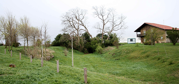
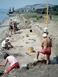
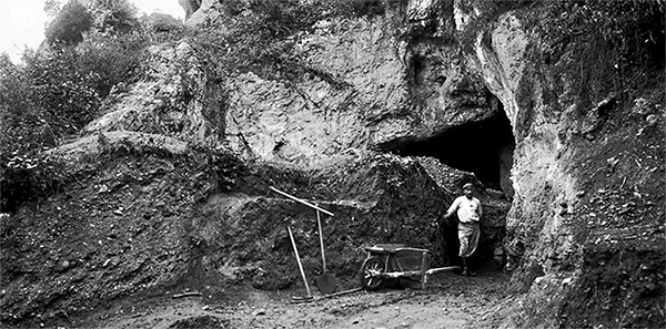
| Avdeevo |
 Above, Avdeevo site. |
|
A high quality chalky flint was used to manufacture the stone tools at Avdeevo. A total of 24 100 flint finds was collected at Avd-St, and 39 496 pieces at Avd-N up to 1986.1 A total of 33 437 items of knapped flint were gathered at K-I.
The presence of cores, and of the products of their reshaping and of striking flakes, indicates that the knapping was done in the living floor area. The usage of flint was economical: large blades were used almost completely for tool manufacturing, broken tools were reshaped and there existed a multiple reshaping of tools in general. See: Homo sapiens |
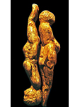
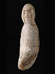
| Balzi Rossi |
 On the Liguria coast to the French border are the entrances of the complex of the caverns of the Balzi Rossi (literally red leaps). The name of the locality derives from the colour of the limestone walls that, because of the iron mineral presence oxidises to a red colour. The complex is composed of numerous coves and shelters. The first searches occurred in 1846-57, by the prince of Monaco, Florestano I., and Louis Alexandre Jullien discovered, between 1883 and 1895, about fifteen figurines, the largest series of venus figures ever found in only one place in Western Europe. |
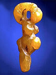
|
The fifteen statuettes were discovered in the sites of Barma Grande, la grotte du Prince, and perhaps le Jardin Abbo, excavated between 1883 and 1895 by Louis Jullien.
The seven Canadian specimens recently surfaced in an antique store in Montreal.They include five representations of women, a possible but uncertain female figure, and a face of indeterminate species and gender. Accompanying documents and interviews with their owners showing that these objects belonged to the collection of Louis Jullien, which had been lost track of in Montreal at the beginning of the 20th Century. The pieces found are generally in good condition and form a substantial sample of the known Gravettian-Epigravettian female sculptures of Western Europe.
See: Homo sapiens |
| Bornholm |
 Bornholm is an island in the Baltic Sea, and Denmark's largest concentration of rock engravings is located just north of Allinge in the northern part of Bornholm. The carvings are more than 2 500 years old. |
|
The engravings are cut into relatively flat granite slabs. They would originally have stood out as white engravings against the grey rock, but have gradually faded to the same colour as the background rock surface.
In order to see them, they must be either be viewed at night by artificial light at a low angle of incidence to the plane of the rock, or else the engravings must be emphasised by colouring with paint. The rock slabs occur randomly across the island. See: Homo sapiens |
| Brno |
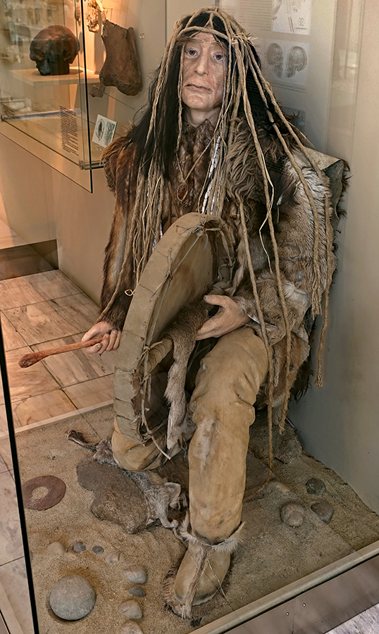
The Brno II burial of a Shaman was discovered by accident in 1891. The stratigraphical position corresponds with that of known sites of mammoth hunters of the Gravettian (Pavlovian). The burial is characterised by several unusual features: its location outside both the site and the settlement area, the state of health of the buried man (dispersed periostitis, flection of the femur), unusual grave goods such as a male idol or puppet (the only anthropomorphic sculpture to be found in a palaeolithic burial), roundels made of different raw materials with symbolic ornamentation, many hundreds of fossil shells of a single type, a large amount of bones from a large game animal, and the absence of any item of practical use. The buried man apparently held a significant position in the ritual sphere. |
|
Brno Shaman - a marionette was found in the grave of what has been interpreted as a shaman. 28 000 years ago a 10 year old boy began to suffer from an excruciating, even unbearable pain in his hands and legs. He suffered from periostitis, an inflammation of the periosteum, a dense membrane composed of fibrous connective tissue that closely wraps all bone, except the bone of articulating surfaces in joints which are covered by synovial membranes. He learned how to defeat his pain, grew up into a strong man and become a shaman because of his abilities and qualities. He possessed a fascinating cap sewn with some 600 shells (of the Dentalium badense, a marionette, many discs made of various materials and several animal skulls. When he died, the survivors broke his drumstick, and one of its parts was placed in his grave together with the other things that he was using. It is possible that they placed the other part on the top of the grave together with the drum. This custom still exists in some Arctic communities. See: Homo sapiens |
|
The Bohunician Culture is an Initial Upper Palaeolithic culture, incorporating elements of the Mousterian with the lower Aurignacian. The term 'Bohunician' is derived from the word Bohunice, the name of a suburb in the western part of the city of Brno, where this specific industry was first investigated. The stone tools often were produced from Levallois blade cores with hard-hammer percussion and include many forms considered typical of Upper Palaeolithic industries associated with modern humans (that is, end scrapers and simple burins), as well as Levallois points and side scrapers. Some assemblages also contain bifacial leaf-shaped points (more common in the northern sites)
See: Homo neanderthalensis |
||
|
Pekárna is a large tunnel cave in the southern part of the Moravian Karst, in the cadastral area of Mokrá near Brno (part of Mokrá-Horákov), 1.5 km southeast of the village of Ochoz u Brna, 11 km NE of Brno. It is important for its Venus figure, the venus of Pekárna, in the Lalinde/Gönnersdorf tradition. With its 6 m high and 23 m wide portal, the cave opens into the Říčka Valley. It represents an important archaeological site. The cave is made up of a single 64 m long corridor, which is almost wholly lit by daylight. The end of the cave is formed by a large boulder cave under the chimney. The entrance to the cave is 5 metres high and 20 metres wide and its shape resembles a massive bread oven. As a result of its entrance, the cave was named Pekárna (Bakery in english). See: Homo sapiens |
||
|
Kůlna Cave is located 45 km from Brno, and forms a massive tunnel on the eastern slope of the Sloupské Valley. The first archaeological excavation was carried out in 1880 by J. Wankel and a year later M. Kříž began extensive excavations, which lasted until 1886. The discovery layer of the Middle Paleolithic was first identified by his successor Jan Knies. The researches of the Anthropos Institute in the years 1961-1976 brought not only extensive collections of Middle Palaeolithic tools and at the same time the oldest evidence of the settlement of the Moravian Karst, but also the most numerous remains of Neanderthal man in the Czech Republic. The collaboration of many natural scientists has brought a lot of ecological data. The oldest settlements fall at the end of the penultimate (Risian) ice age, followed by a culture called Taubachien ( Neanderthal, 130 000 to 80 000 BP) with small-scale tools using mostly pebbles as cores, in the warm interglacial. The remnants of the Neanderthals (skull fragment, upper jaw, and 3 milk teeth) come from layer 7a, which belongs to the Micoquian. See: Homo neanderthalensis |
||
|
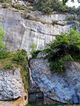
Švédův Stůl Cave is located in the southern part of the Moravian Karst Protected Landscape Area (PLA) in the Říčka Valley near the Ochoz Cave and the Pekárna Cave, 49° 14′ 43.3″ N, 16° 44′ 52″ E, approximately 10 km from the city of Brno.
It is a short 'through cave' in a rock block (hence the name Swede's Table). Besides cave bears, hyenas and other animals inhabited the cave as well as Neanderthals 100 000 years ago, as well as a younger culture during the Neolithic and Bronze Age. Archaeological research of the site was conducted by Bohuslav Klíma. See: Homo neanderthalensis |
||
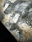
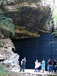
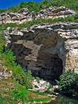
| Chauvet Cave |
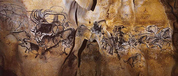 Chauvet Cave in the valley of the Ardèche River in France is filled with paintings, engravings and drawings created more than 30 000 years ago, of cave lions, mammoths, rhinos, bison, cave bears and horses. It contains the earliest known cave paintings, as well as other evidence of Upper Palaeolithic life. It is situated on a limestone cliff above the former bed of the Ardèche River. The cave was first explored on December 18, 1994. As well as the paintings they discovered fossilised remains, prints, and markings from a variety of animals, some of which are now extinct. |
|
Chauvet Cave is situated above the previous course of the Ardèche River before the Pont d'Arc opened up. The Chauvet Cave, however, is uncharacteristically large and the quality, quantity, and condition of the artwork found on its walls is stunning. Most of the artwork dates to the earlier, Aurignacian, era (30 000 to 32 000 years ago). The later Gravettian occupation, which occurred 25 000 to 27 000 years ago, left little but a child's footprints, the charred remains of ancient hearths and carbon smoke stains from torches that lit the caves. After the child's visit to the cave, evidence suggests that the cave had been untouched until discovered in 1994. The footprints may be the oldest human footprints that can be dated accurately. Near-toxic levels of carbon dioxide and radon mean that visitors can enter the cave for only a few hours each day.
See: Homo sapiens |
| Dolní Věstonice |
 Dolní Věstonice, in the south central Czech republic is a site of prime importance, and from the buried remains of this ancient community an intriguing picture of domestic life in Europe 27 000 years ago can be reconstructed. It represents the first use of ceramics in all human history, and a number of outstanding venus figures have been found here. |
|
The Venus of Dolní Věstonice is a ceramic statuette of a nude female figure dated to circa 31 000 BP, which was found at the Gravettian site, Dolní Věstonice, in the Moravian basin south of Brno. This figurine, together with a few others from nearby locations, is the oldest known ceramic in the world, predating by more than ten thousand years the use of fired clay to make pottery. See: Homo sapiens |
|
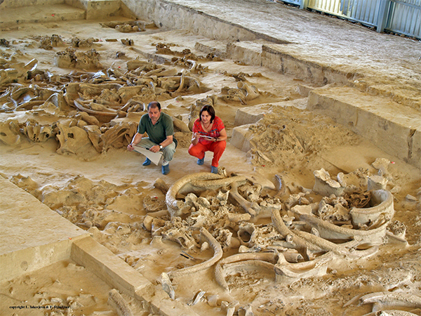
Milovice - the complex of Gravettian stations near Milovice lies in a side valley without a view of the Dyje (Thaya) River, aside from the main settlement area, below Pálava. During the loess mining on the dam of the Nové Mlýny reservoirs, M. Oliva from the Anthropos MZM Institute carried out the rescue research. The site is notable for the huge amount of accumulated bones of mammoths for which the valley provided extremely suitable conditions for hunting.
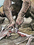
These large accumulations cannot be explained as mere kitchen waste or a raw material store. There are too many large and heavy bones that have not been used (lower jaws, skulls, pelvis, shoulder blades), and a number of isolated molars and tusks. These mysterious depositions resemble rather the collection of bones of prestigious game for representative and transcendental reasons. From other ethnological sources we know hunters burned bones or hung them on trees, put them in swamps, etc. for the sake of reconciliation of some protective spirit - the so-called. "Lord of the Beasts". Prehistoric game animals were partners, not just prey. For the mammoth hunters, everyday life is interwoven with festivities and rituals, the most important of which could be the deposit of the widest selection of bones from the catch. See: Homo sapiens |
||
| Dordogne |
 |
|
Combe Grenal is an archeological site consisting of a collapsed cave and a slope deposit near Domme, Dordogne, France. It dates from ca 175 000 BP to ca 50 000 BP. The cave was first thoroughly excavated by François Bordes from 1953 to 1965. The site's stratigraphic sequence is 13 metres in depth and has at least 64 layers. 55 layers are Mousterian while the 9 layers near the bottom are Acheulean. The oldest layers date back to the end of the Riss glaciation and the youngest to the Würm glaciation. La Grotte de Combe-Grenal gisement at present consists of a small cave, preceded by a rock overhang, located on the south-facing slope of a small dry valley only one kilometre to the south of its confluence with the main Dordogne valley. Excavations carried out by François Bordes between 1953 and 1965 revealed a sequence of almost 13 metres of rich archaeological deposits, apparently spanning the period from the final stages of the penultimate glaciation (isotope stage 6) through to almost the end of the Mousterian succession.
See: Homo neanderthalensis |
|
Combe-Capelle is a Neanderthal site in Southern France. The Abri Peyrony, or Haut de Combe-Capelle was excavated by Peyrony in 1925. The archaeological deposits, which were not very thick, were situated on two terraces of bedrock. Based both on Peyrony's description and testing carried out in 1990 there appear to be two levels. The upper level is composed of brownish-red sediments which recall the sediments of the plateau immediately above this locale, while the lower level is composed of greyish concreted sediments.
The rich and highly patinated industry recovered by Peyrony (including many of the pieces that he had originally left in his backdirt and which were later recovered by Paul Fitte), is clearly attributable to the Mousterian of Acheulian Tradition, containing numerous small cordiform bifaces, scrapers, denticulates/notches, and Levallois flakes. See: Homo neanderthalensis |
||
|
Chapelle-aux-Saints - The old man of Chapelle-aux-Saints was intentionally buried. The skeleton lay at the bottom of a pit in the marly floor of the cave. There were, around the rest of the body, a large number of fragments of quartz and of flint, sometimes worked well, as well as a few fragments of ochre and broken bones, as in the rest of the archaeological layer. See: Homo neanderthalensis |
||
|
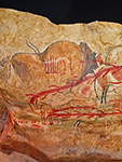
Grottes de Cougnac - Gravettian and Magdalenian paintings The Grottes de Cougnac caves are near Gourdon, Lot. The site consists of two caves separated by 200 metres. The first contains many concretions, some very fine, called soda straws. The second is a decorated cave from the Palaeolithic. The cave has many prehistoric paintings dated to the upper Palaeolithic. Depictions include deer, Megaloceros, the ibex, and mammoths as well as various schematic human figures, interpreted as wounded men, virtually identical to similar figures at Pech Merle. Direct dating has been carried out by the carbon 14 method on samples of carbon used for some drawings. They showed that the paintings corresponded to at least two clearly distinct phases: one around 25 000 BP (Gravettian) corresponding to the animal figures, the other during the Magdalenian, about 14 000 years before the present.
See: Homo sapiens |
||
|
Grotte de Cussac or Cussac Cave contains over 150 Palaeolithic artworks as well as several human remains. It is located in the Dordogne River valley in Le Buisson-de-Cadouin, Dordogne, Aquitaine, France.
The cave's artworks are estimated to be 25 000 years old, and are almost exclusively engravings, often very large, made with stone tools on the walls, or with fingers on clay soil. Pigments are limited to very few red dots. They include both classic instances of Upper Paleolithic animal art (bison, horses, mammoths, rhinoceroses, ibex) and rarer images including birds, enigmatic figures, and perhaps four female profiles. All appear close in theme and style of those known to be Gravettien in the Quercy caves, in particular Pech Merle. The cave's human remains appear to represent one of very few associations of parietal works and human burials in Paleolithic Europe. At least five people, four adults and a teenager, were deposited in the cavities, with bones dated by Carbon 14 measurements to approximately 25 000 years in age. See: Homo sapiens |
||
|
La Gravette is the type site for the Gravettian culture. It was here that its characteristic tools were first found and studied. It dates from between 28 000 and 22 000 years ago. Artistic achievements of the Gravettian cultural stage include hundreds of Venus figurines, which are widely distributed in Europe. See: Homo sapiens |
||
|
Roc-de-Cave was excavated in 1928 under difficult conditions. Long neglected, this skeleton was sprinkled with ochre, is archaeologically complete, and the skeleton is well dated: 11 210 ± 14 BP. It is probably an adolescent aged between 15 to 18 years, sex indeterminate, and is of average stature (1.50 m). The archaeological context (curve-backed blades) and the presence of deer teeth confirm its cultural attribution to the late Magdalenian.
See: Homo sapiens |
||
| Eliseevichi |
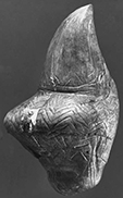
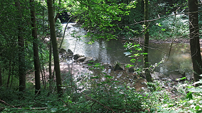
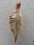
 The Eliseevichi / Yeliseevichi / Yeliseyevichi / Елисеевичи site was discovered in 1930 and it is located near the river Sudost, the right tributary of the Desna, in the Briansk Province, Russia, the shallow valley of which is shown above. The majority of prehistoric artefacts were found in a heap of mammoth skulls piled next to a residential house. The most remarkable of these is a finely modelled 15 cm tall figure depicting a shapely woman with no feet, head and hands, carved of mammoth tusk. The figurine has prominent buttocks and legs. |
|
This venus figure appears never to have had a head, and the sculpture emphasises the thighs and buttocks rather than the breasts, although they are certainly indicated. This has the look of a younger figure which has not yet gone through childbirth. The waist is slim, the hips and thighs are well formed, as are the breasts, unchanged by child-rearing. It has quite a different emphasis and seems from a different tradition when compared with most other Kostenki venuses, nor for that matter with most of the other Gravettian venuses from France, for example. It has affinities with the unusual 'venus impudique' from France. See: Homo sapiens |
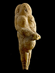
| Frasassi |
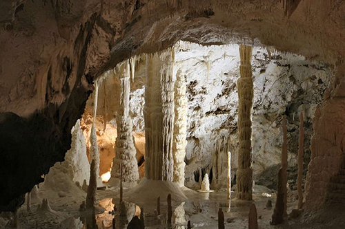 The Grottes di Frasassi are a remarkable karst cave system in the municipality of Genga, Italy, in the province of Ancona, Marche. They are among the most famous show caves in Italy. The formation on the left is known as the organ pipes. The caves were discovered by a group of Ancona speleologists between 1948 and 1971. Rich in water, the cave system is particularly well endowed with stalactites and stalagmites. |
|
The Venus of Frasassi was carved from a piece of stalactite. It is from the Upper Palaeolithic, between 28 thousand and 20 thousand years ago. The face is barely shown. Breasts are large, and placed high on the chest. A navel is shown on the full abdomen, and the vulva is clearly shown in relief. Legs taper to about below the level of the knees, which are not shown, when they are broken off or were never carved. Most unusually, the forearms extend well in front of the body, as though they were used to hold something. It is difficult to be sure from the photo, but it seems that the head has been carved in two portions, with a groove between the front and back.
See: Homo sapiens |
| Fumane Cave |
 A fossil marine shell, Aspa marginata, was discovered in a Mousterian layer of Fumane Cave, northern Italy, and was dated to 47 600 cal BP. Analysis shows that this fossil gastropod was collected by Neanderthals, at a Miocene or Pliocene fossil outcrop, the closest of which is located more than one hundred kilometres from the site. |
|
Fumane Cave - the shell was smeared with a pure, finely ground, hematite powder, probably mixed with a liquid. It was perhaps perforated and used as a personal ornament before being discarded, lost or intentionally left at Fumane Cave, some 47 600 - 45 000 cal BP. The minimum age of the Fumane unit in which the Aspa marginata was found predates the oldest available dates for the arrival of anatomically modern humans (AMH) in Europe, thus supporting the hypothesis that deliberate transport and colouring of exotic objects, and perhaps their use as pendants, was a component of Neanderthal cultures.
See: Neanderthal painted shell |
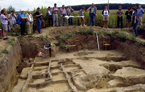
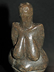
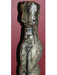
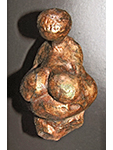
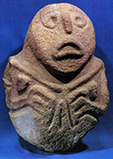
| Gagarino |
 The Gagarino Double Venus, as interpreted by the talented artist Libor Balák. Gagarino is located on a loess terrace on the north lip of a ravine on the right bank of the Don River about five kilometres north of the junction of the Sosna, a tributary stream. It is north of the well known Kostienki sites. Here peasants discovered a house pit while excavating a silo trench. A house pit was found, roughly oval in outline about 5.5 metres long and 4.5 metres wide. The floor was located 40 to 60 cm below the occupational surface. |
|
The double statuette of Gagarino, 148 mm x 52 mm x 12 mm, shown at left, has been the subject of much debate.
However the unfinished nature of Palaeolithic statuettes is a widespread phenomenon. It is probable that completion of the double statuette of Gagarino was abandoned after a fracture developed during manufacture. It is fascinating to wonder whether there is some relationship with the double burial at Sunghir, although since it is at least 500 km distant, this is unlikely, and it is probable that the double statuette is simply an unfinished statuette, done in a pair for convenience. There are eight Palaeolithic ivory Venus figurines from Gagarino. The statuettes belong to the Gravettian industry and are about 21 000 years old. See: Homo sapiens |
| Galgenberg |
 Venus vom Galgenberg, the oldest figurine of a woman apart from the Berekhat Ram figure and the Venus of Hohle Fels ever found, was created around 30 000 BP. It was found on September 23, 1988 during the excavation of a habitation of palaeolithic hunters at Galgenberg near Stratzing (Lower Austria), broken into several pieces. It is a 72 mm high figurine of a woman weighing 10 gm and is made of greenish, very shiny amphibolite slate, the upper body is turned to the side, in a dancing position, three-dimensional front, flat back, believed to have had cultic or religious significance. The stone material is from the immediate vicinity of where the figurine was found, and the waste material provides proof that the figurine was made in the same area. |
|
It is highly probable that the statuette was manufactured at Galgenberg. The occurrence of amphibolite schist at a distance of several hundred metres from the site, as well as many small fragments of this raw material in the area of the fragments of statuette, which may be waste from the original carving, support this assumption. The statuette itself is an upright standing figurine without feet, one leg touching the other at the feet. The legs are separated by a pointed oval perforation.
The left leg is straight while the right one is flexed. The transition from the hips to the upper part of the body is rounded, which can be seen especially from the back. The right arm is also separated from the body by a pointed oval perforation and touches the thigh. See: Homo sapiens |
| Gönnersdorf |
 The open-air site of Gönnersdorf is situated at the right bank of the Rhine, at the north-western exit of the Neuwied Basin, about 15 km northwest of the city of Koblenz and immediately east of the Andernacher Pforte (Andernach Gate). The site was found on a spur, of a triangular piece of land, which is 3 km long and 1 km wide. Directly west of the settlement, was a small stream running through a narrow, steep valley and draining into the Rhine. The valley both protected the people from the worst of the weather, and supplied them with the slate that was used for pavement in the settlement area Towards the northwest, the site was protected by the slope of the high terrace, and was easily accessible only from the east. The settlement is strategically placed, oriented towards south and is exposed to the full trajectory of the sun and has an excellent view over the Neuwied Basin. The settlement structures were buried by pumice after the last large eruption from the Laacher See Volcano, located 11 km west of Gönnersdorf, at the middle of the Allerød interstadial, about 12 900 cal BP. Due to this thick cover of pumice, the remains at the site are well preserved. |
|
Gönnersdorf was a site of inter-regional importance, and was the centre for the type of venus figures now known as the Gönnersdorf culture. They figurines and engravings are highly sylised, abstract figures of women, in a very recognisable style. It has the most numerous and widely different representations of any other centre for the Gönnersdorf venus figurines, the examples of which are spread over a thousand kilometres or more of present day Europe. See: Homo sapiens |
| Gontsy |
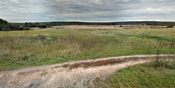
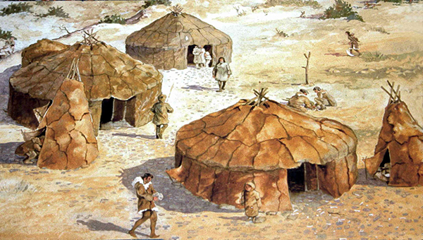
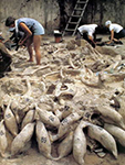
 Gontsy was the first Upper Palaeolithic site to be found on the central Russian Plain, in 1871, and is the site of a series of mammoth bone huts. It has strong affinities with the site of Mezyn. Gontsy is located on the right (southern) promontory formed by the second terrace of the Udaï River. The promontory faces north and is bordered today, as it was at the time of occupation, by ravines and the floodplain. It has been extremely well researched by Lyudmila Iakovleva and François Djindjian, who have not only described the site in a professional manner, they have done excellent work in teasing out exactly why and how the phenomenon of mammoth bone huts in the Dniepr plain occurred. Their paper entitled L'habitat à cabanes en os de mammouths de Gontsy (Ukraine) is a masterpiece. |
|
The long-term excavations of the Late Upper Palaeolithic settlement of Gontsy (Ukraine), with its mammoth bone huts and associated mammoth bone bed, has allowed the reconstitution of nearly all of the pieces of the puzzle of this type of settlement, and the definition of the major role in the economy of the mammoth in the Mezinian (of the Mezyn site culture) peopling of the middle and upper Dnepr basin (Ukraine and Russia). The settlements generally share the same geomorphology of the location on a promontory cut by ravines on the slope of a river valley. The dwelling area is organised around mammoth bone huts, numerous pits around each hut, large working areas with hearths, dumping areas, butchering areas for small and medium mammals, and the existence of a mammoth bone bed which has been largely exploited during the occupation of the settlement. The landscape analysis, using information from mapping, functions, and seasonality of the settlements, has characterised a particular system based on the economy of the mammoth, limited to a short period between 15 000 BP and 14 000 BP, at the beginning of the climatic change ending the last ice age. The network connections are supported by raw material procurement from a wide area, particularly flint and shells, but also amber, demonstrating the long distances travelled by the hunter-gatherer groups, both for the yearly search for the next settlement, and during the annual cycle for various seasonal procurements. See: Homo sapiens |
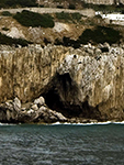
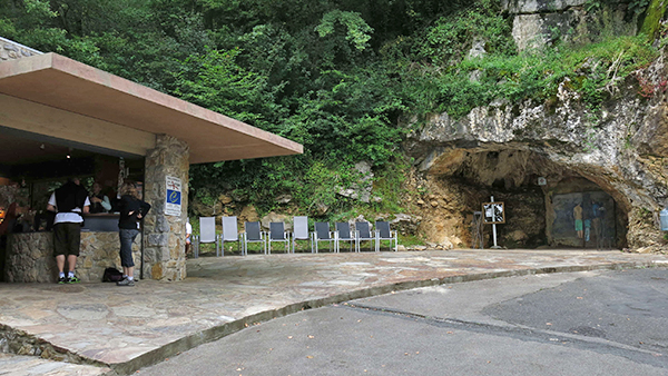
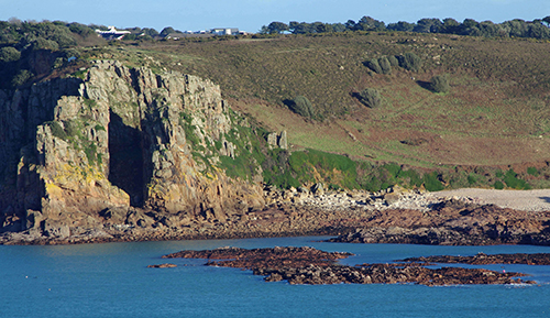
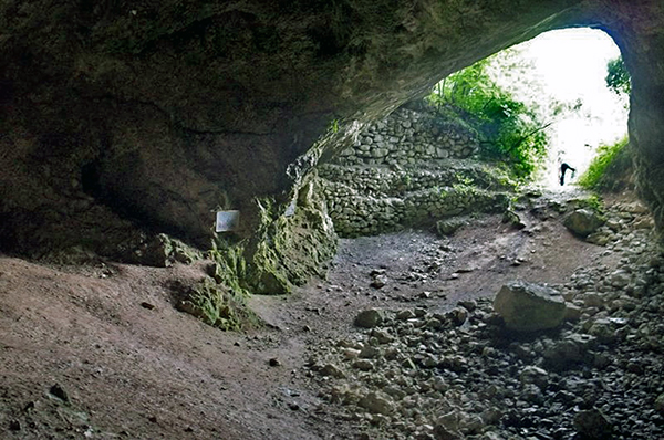
| Gorham's Cave |
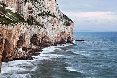 Forbes' Quarry, close by Gorham's Cave, was also inhabited by Neanderthals, and we have a skull from that site. |
|
Gorham's Cave - Excavation of this site has resulted in the discovery of four layers of stratigraphy. Level I has produced evidence for eighth to third centuries BC use by Phoenicians. Below that, level II produced evidence for brief Neolithic use. Level III has yielded at least 240 Upper Paleolithic artefacts of Magdalenian and Solutrean origin. Level IV has produced 103 items, including spear-points, knives, and scraping devices that are identified as Mousterian, and shows repeated use over thousands of years.
See: Homo neanderthalensis |
|
Forbes' Quarry was the site of the 1848 discovery of the first Neanderthal skull by Lieutenant Edmund Flint of the Royal Artillery. The fossil, an adult female skull, is referred to as Gibraltar 1 or the Gibraltar Skull. Although it was discovered before the hominin from the Neander Valley, this was not recognised at the time, so the Neander Valley hominin became the type specimen. See: Homo neanderthalensis |
||
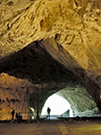
| Grotta del Cavallo |
 |
|
Grotta del Cavallo contains a rich stratigraphic succession with a depth of 7 m that is deposited on top of an interglacial beach foundation. The most notable section of this sequence covers the Middle Palaeolithic, associated with the Neanderthal Mousterian culture and recently discovered subsequent strata that were associated with the earliest known appearance of anatomically modern humans in Europe.
See: Homo neanderthalensis |
| Grotta dei Moscerini |
 |

|
Grotta dei Moscerini is one of two Italian Neanderthal sites with a large assemblage of retouched shells (n = 171) from 21 layers. The other occurrence is from the broadly contemporaneous layer L of Grotta del Cavallo in southern Italy (n = 126). Eight other Mousterian sites in Italy and one in Greece also have shell tools but in a very small number. The shell tools are made on valves of the smooth clam Callista chione. At Moscerini 23.9% of the specimens were gathered directly from the sea floor as live animals by skin diving Neanderthals.
See: Homo neanderthalensis |
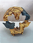
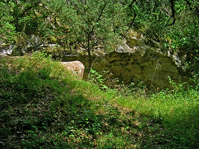
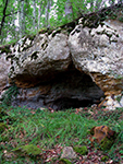
| Gruta da Aroeira |
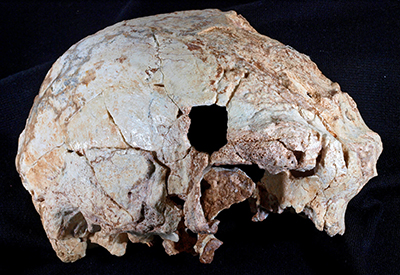 |
|
Gruta da Aroeira - the cranium represents the westernmost human fossil ever found in Europe during the middle Pleistocene epoch and one of the earliest on this continent to be associated with the Acheulean stone tool industry. In contrast to other fossils from this same time period, many of which are poorly dated or lack a clear archaeological context, the cranium discovered in the cave of Aroeira in Portugal is well-dated to 400 000 years ago and appeared in association with abundant faunal remains and stone tools, including numerous bifaces (handaxes).
See: Homo heidelbergensis |
| Heidenschmiede |
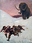
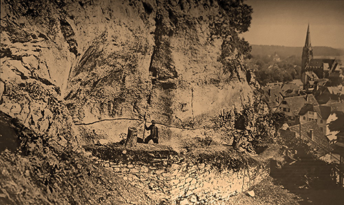 Mammoth, wooly rhinoceros, horse, reindeer, wolf, fox, hare and marmot were found. In addition, there were also the Bean Goose ( Anser fabalis ), Herring Gull, Mallard, Ruff, Willow Ptarmigan , Jackdaw and owl. The cold animal species among them show that this was a tundra landscape, with subarctic forest in protected areas close by. |
|
Along the southwestern bulwark of the castle in Heidenheim, the rock face 35 metres above the valley floor forms a small overhang just large enough to create an 8 square metre abri, or rock shelter. Together with the open space in front of it, the cave has a usable area of some 30 square metres.
In spite of its small size, this so-called Heidenschmiede, or heathen's forge, rock shelter was a place our ancestors went to time and again. This may have been because of the splendid view across the wide, open valley of the Brenz River, which provided an excellent hunting ground. The handaxes and flake tools found there are made to a large extent from chert coming from deposits in the area near Stuttgart, circa 120 000 BP - 50 000 BP. See: Homo neanderthalensis |
| Isturitz |
 |
|
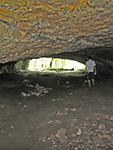
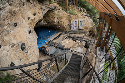
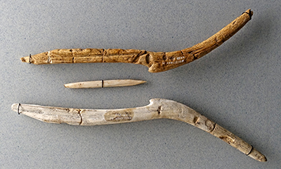
Isturitz - the main entrance to the cave Isturitz was known in medieval times. It is distinct from the current entry, created later. The first prehistoric objects were found at the end of the nineteenth century. Isturitz is famous for the discovery of a series of important prehistoric flutes dating from the Upper Paleolithic (Aurignacian to the Magdalenian), about 35 000 BC to 10 000 BC. The Périgordien period accounts for two thirds of the discoveries. There are also bone harpoons, figurines of bison on a sandstone plate (Magdalenian), and heads of propulseurs or spear throwers made of reindeer antler from the Middle Magdalenian. René de Saint-Perier excavated there in the early twentieth century. The other two caves, Oxocelhaya and Erberua, also contain carvings and cave paintings, but only Isturitz is open to the public. See: Homo sapiens |
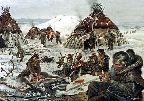
| Kostenki |
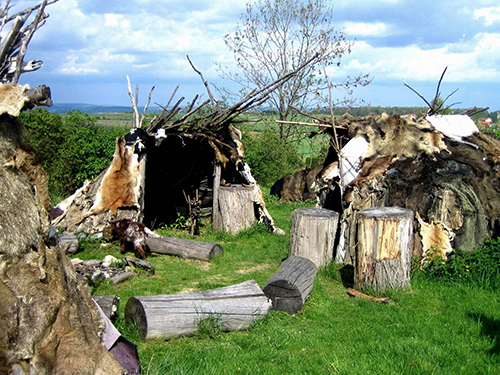
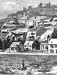
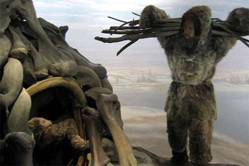
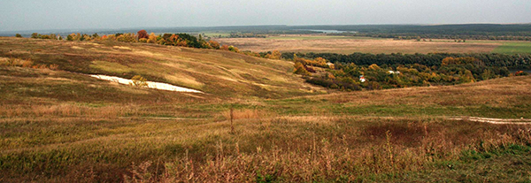 View of the village of Kostenki from high ground above the settlement near the Don River, visible to the right of the houses. A distant loop of the Don may be seen in the background. Kostenki is a very important Palaeolithic site on the Don River in the Russia. It was a settlement which contained venus figures, dwellings made of mammoth bones, and many flint tools and bone implements. Kostenki / Kostienki is not actually a single site but really an area on the right bank of the Don River in the regions of the villages of Kostenki and Borshevo, consisting of more than twenty site locations, all dating to the Paleolithic. |
|
The Don River flows down the fault line between the uplifted Central Russian Upland and the Tambov Lowland. This fortuitous circumstance means that the uplift provided ravines and associated springs for water during winter, and also provided high ground above the river terraces which gradually covered the settlements by colluvial action, as well as successive uplifts of the land, so that successive settlements were separated first (vertically) by colluvial sediments and secondly by the uplift, leading to the settlements being separated by (horizontal) distance as well on the three main terraces.
Further, modern settlers found the area to be congenial, and sunk house foundations and cellars which uncovered the mammoth bones which first alerted people to the unusual nature of the area, and erosion of the ravines also provided access to evidence of previous settlements. However the houses are scattered widely over the area, and excavations of sites can be made without greatly inconveniencing the local population, as would be the case in a large town or city. There is a good road to the region from a major city not far away, but the road does not cross the area of interest, which is serviced by a network of minor, mostly dirt roads. The area is not under threat of flooding or other disturbance, and the area is politically stable, so long term careful explorations can be made. A (dateable) fall of volcanic ash conveniently delineates the oldest sediments from the younger ones. Archaeologists could hardly ask for more! See: Homo sapiens |
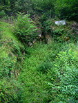
| La Cotte de St. Brelade |
 La Cotte de St Brelade is a Neanderthal site in St Brelade, Jersey. Neanderthals lived there from around 238 000 years ago until between 100 000 and 40 000 years ago - making it the earliest known the occupation of the Channel Islands by a hominin species, and also possibly one of the last Neanderthal sites in northwestern Europe. At that time, with sea levels below those at present, Jersey was part of Normandy, a peninsula jutting out from the coast. After the last Ice Age the sea rose again, separating Jersey from the mainland |
|
The cave is situated on the South-western side of the island, in the Eastern horn of the Bay of St Brelade. At this part of the coast, the cliffs, which are of a coarse grained syenitic granite, rise more or less vertically to an elevation of about 200 feet (60 metres) above mean tide level, and the shore at their base consists of flat granite rock, covered for the greater part with large boulders which have fallen from the cliffs.
In one part of this coast there is a gorge 40 feet (12 metres) in width, which enters at right angles to the shore line for a distance of about 150 feet (45 metres). This has vertical walls, exactly parallel with one another, and it is in one of these wall, the one with the southern aspect, and near the inner extension of the gorge, that the cave is situated. See: Homo neanderthalensis |
| La Quina |
 La Grotte de Villars, 50 km east of La Quina, is the only cave in the Périgord to house both original prehistoric paintings and concretions. An underground river has hollowed out huge chambers connected to each other by galleries. On the walls are paintings made more than 19 000 years ago. Some like the rotunda of the horses are covered with a thin film of calcite that gives them a blue colour. The scene of the 'Bison and the Sorcerer' is one of the few human representations in prehistoric art. La Grotte du Placard, about 30 km north of La Quina, is a major deposit which was unfortunately devastated by early excavations. It is more an abri than a cave, and is a large shelter where daylight penetrates. It is close to the Tardoire River, and these qualities made it an ideal habitat. The site was occupied at several times, in the Mousterian period, then, much later, during the Middle and Upper Solutrean, and almost continuously thereafter until the end of the Magdalenian. |
|
La Quina - The skeleton found at La Quina is probably that of a woman. The skull is long, 203 mm; rather narrow in comparison with the length, 138 mm, giving a head index of 68. (138/203*100 = 68% - Don) The eyebrow ridges are as greatly and prominently developed as in male skulls, and such is not the case in skulls of modern women. The jaws of the La Quina woman are strong and the teeth big. The bones of the vault of the skull are about 5 mm in thickness, whereas in the skulls of Neanderthal men in particular and Palaeolithic men in general, the vault has a thickness of 8 or 10 mm. The brain capacity of the skull is estimated by Professor Anthony at 1350 cc, about the same as for modern women, but 250 cc less than the capacity of the La Chapelle man's skull. The stature is calculated to have been 150 cm. See: Homo neanderthalensis |
|
La Grotte de Villars, contains galleries of stalactites and yellow and ochre calcite accumulations, including 17 000 year old prehistoric paintings dating from the same period as those at Lascaux. The slow seepage of water has created some of the most beautiful natural scenery. There are all types of concretions: calcite, thin stalactites, gours, translucent draperies and countless stalagmites. There are cave paintings 17 000 years old. Some, like the rotunda of the horses are covered with a thin layer of calcite that gives them a special blue color.The scene of the bison and the sorcerer is one of the few human representations of prehistoric art. See: Homo sapiens |
||
|
La Grotte du Placard is a decorated cave in the commune of Vilhonneur in Charante, 30 km east of Angoulême, and 30 km north of La Quina.
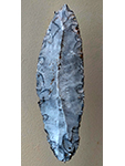
It has been extensively researched and has levels dating from the Middle and Upper Paleolithic, especially the Magdalenian and Solutrean. A dozen aviform signs identical to those discovered in the caves of Pech Merle and Cougnac, were unearthed in 1990 on the walls buried in the Solutrean layer, which suggests a cultural grouping or even a common ancestor who visited these caves which are separated by more than 150 km. Similar signs were found in the Cosquer Cave near Marseille, 500 km away. The figures date back about 20 000 years to the Solutrean. The signs are known as Placard type signs. See: Homo sapiens |
||
| Las Caldas |
 |
|
The figure is a composite representation that combines human body proportions with some animal features. The torso has human proportions, being 50% of the total height, the pelvic-abdominal area is centred on the pubis. As well, the gracefulness of the trunk, marked shoulders and engraved external genitals are human. In contrast, the triangular head has the horns of a goat, and the feet are cloven-hoofed.. See: Homo sapiens |
| Lepenski Vir |
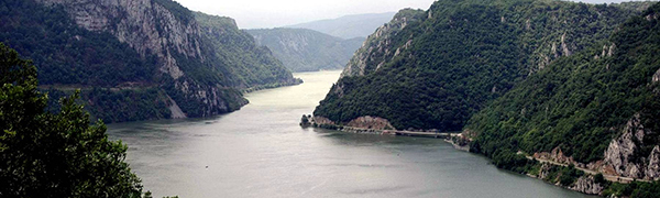 |
|
The Lepenski Vir culture is recorded clearly and in detail. Its stratigraphy has been plotted, the basic elements of its structure are known and the course of its development is clear. None the less, it is today a phenomenon isolated in time and space. The forms of a highly developed culture, a permanent settlement with an architectural plan which presupposes complex socio-economic relationships, and examples of monumental art certainly imbued with a profound religious sense, have been found at Lepenski Vir, initially a featureless area affording no sort of expectation of discoveries, nor of any tradition of earlier settlement. On the other hand, all the essential forms of the Lepenski Vir culture differ completely from the general cultural-historical pattern of the early prehistory of Europe. It seems that nothing created in the Danube Basin before or at the time of the flowering of the Lepenski Vir culture (Early and Middle Stone Age) can explain its exceptional nature, nor are its highly expressive activities endorsed by the events that directly followed it (the beginnings of the oldest culture of the Late Stone Age, Starčevo-Körös-Cris types). The Lepenski Vir culture had its precursors but not its ancestors; its heirs are known but not its descendants.
See: Homo sapiens |
|
The Iron Gates region on the Donau (Danube) River has a number of other very important mesolithic sites. See: Homo sapiens |
||
| Les Eyzies |
 Nearby are many very important archaeological sites, situated there by the unique geology of the Les Eyzies area. Both times I have visited, I have spent two weeks exploring the area and visiting the caves and abris, as well as spending a lot of time in the excellent Museum there. If you only go to one area of France in the pursuit of a love of archaeology, this is the place to go. First, here is a clickable map which will take you to the various sites, click on it to get to the interactive map, then click on the red dots to go to the various sites: 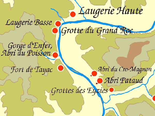 The names read like a rollcall of the world's most important artistic and evolutionary treasures: La Grotte de Lascaux La Grotte de Rouffignac Le Moustier The Cro-Magnon Shelter Le Moustier Le Ruth and Le Cellier Laugerie Haute Laugerie Basse Castel Merle Roque St Christophe L'Abri Poisson and La Gorge d'Enfer L'Abri Pataud Font de Gaume Les Combarelles La Grotte de la Mouthe La Grotte de Bernifal L'Abri du Cap Blanc L'abri de Laussel La Micoque Le Regourdou Roc de Marsal La Grotte de Bara Bahau La Grotte de Gabillou La Grotte de Badegoule Apart from the links above, I have here on the right only linked to a few of the most important sites, with a brief description. |
|
Le Grotte des Eyzies, also known as the Grotte Richard, is located on the left bank of the Vézère. It opens to the SSE in the line of rocky cliffs which border the right bank of the Beune, a few hundred metres to the East of the Château-Musee des Eyzies and 35 metres above the line of the river. When, in 1863, Lartet and Christy entered this cave, they found on the floor a very hard black breccia, which was made of bones and cut flints. The cave had, however, been emptied of much of its important archaeological deposits in the Middle Ages, and important discoveries were made by Peyrony who excavated this mass of spoil.
See: Homo sapiens |
|
The Cro-Magnon shelter was discovered in 1868, when road works uncovered the remains of several individuals which were identified in this shelter. French geologist Louis Lartet was called in for excavations, and found the partial skeletons of four prehistoric adults and one infant, along with perforated shells used as ornaments, an object made from ivory, and worked reindeer antler. These 'Cro-Magnon men' were identified as the prehistoric human race of Europe, as distinct from Neanderthal Man, described a few years earlier by William King based on the Neanderthal 1 fossil discovered in Germany in 1856. The term 'Cro-Magnon Man' soon came to be used in a general sense to describe the oldest modern people in Europe. By the 1970s, the term was used for any early modern human wherever found, as was the case with the far-flung Jebel Qafzeh remains in Israel and various Paleo-Indians in the Americas. The term 'Cro-Magnon' remains in use, but since the late 1990s has typically been restricted to European early modern humans. See: Homo sapiens |
||
|
Lascaux Cave is famous for its Paleolithic cave paintings. The original caves are located near the village of Montignac. The paintings are estimated to be 17 300 years old. They primarily consist of images of large animals, most of which are known from fossil evidence to have lived in the area at the time. The cave was discovered on September 12, 1940 by four teenagers, Marcel Ravidat, Jacques Marsal, Georges Agnel, and Simon Coencas, as well as Marcel's dog, Robot.
The cave complex was opened to the public in 1948. By 1955, the carbon dioxide produced by 1 200 visitors per day had visibly damaged the paintings. The cave was closed to the public in 1963 in order to preserve the art. After the cave was closed, the paintings were restored to their original state, and were monitored on a daily basis. Rooms in the cave include The Hall of the Bulls, the Passageway, the Shaft, the Nave, the Apse, and the Chamber of Felines. Lascaux II, a replica of two of the cave halls — the Great Hall of the Bulls and the Painted Gallery — was opened in 1983, 200 metres from the original. See: Homo sapiens |
||
|
Le Moustier is an archeological site consisting of two rock shelters in a hill above the village of le Moustier. It is known for a fossilised skull of the species Homo neanderthalensis that was discovered in 1908. The Mousterian tool culture is named after Le Moustier, which was first excavated from 1863 by the Englishman Henry Christy and the Frenchman Édouard Lartet.
The skull known as 'Le Moustier' is estimated to be approximately 45 000 years old. Its characteristics include a large nasal cavity and a somewhat less developed brow ridge and occipital bun, as might be expected in a juvenile. See: Homo neanderthalensis |
||
|
Laugerie-Haute is one of the most important archaeological sites in France for the classification of the Upper Palaeolithic . It contains a sequence of layers of the Gravettian, Solutrean, Badegoulian and Magdalenian.
The abri, open to the southeast, is located about two kilometres upstream from Les Eyzies-de-Tayac-Sireuil on the right bank of the Vézère. Compared to Laugerie Basse, it is a little further upstream. The steep face consists of flat-lying limestone. The total length of the rock overhang is about 180 metres, with a depth of 10 metres. However, the investigation area is only 132 meters in length, since towards the end of Magdalenian III (around 14 000 BC) collapsing rock overhangs partially buried the settlement area. These tumbled rocks allow archaeologists to divide them into Laugerie-Haute Est and Laugerie-Haute Ouest. The border is marked by a house built in the 17th century ('Chapoulie Castle'), which uses the rock as a back wall. With an estimated depth of 35 metres, Laugerie-Haute may have been one of the most impressive abysses in France before it collapsed. See: Homo sapiens |
||
|
La Micoque is an open-air Mousterian / Mousterien site at the foot of a rock face on the left bank of the ru de Manaurie which flows into the Vézère, upstream of Laugerie Haute. La Micoque was discovered in 1895 by E. Rivière and extensively excavated between 1906 and 1914 by the Swiss antiquarian O. Hauser.
There are two Mousterian groups of deposits, and an Acheulean above that. The deposits are from the ancient Palaeolithic, dating from 400 000 BP to 130 000 BP. See: Homo neanderthalensis |
||
|
Le Regourdou
is one of the most important Neanderthal sites in France. Excavated by Georges Laplace and Eugene Bonifay, the bones of Le Regourdou 1 are the remains of a young Neanderthal adult, of undetermined sex, from the beginning of the last glaciation, about 90 000 years ago. The archeological site of Regourdou is located on the same hilltop as Lascaux, 800 metres from the famous caves. There are two Mousterian groups of deposits, and an Acheulean above that. The deposits are from the ancient Palaeolithic, dating from 400 000 BP to 130 000 BP. See: Homo neanderthalensis |
||
| Mezhyrich |
 |
|
Inside the Mezhirich building, there were some remarkable finds: amber ornaments and fossil shells, transported an estimated 350 to 500 kilometres from their source, and the remains of one of the earliest percussion instruments ever found. The 'drum' consisted of a mammoth skull set at the entrance porch and painted with a pattern of red ochre dots and lines. The top of this skull bears depressions where it seems to have been beaten by 'drumsticks', the animal long bones that were found to bear corresponding damage on their ends. It is possible that the building may have served some ritual or communal function at which the mammoth bone rhythms were beaten out, although many Ukrainian huts of a similar size seem to have been ordinary living places. See: Homo sapiens |
| Mezyn |
 Above, Mezyn National Park. The site was open to the south and protected by the plateau to the north. Shovkoplyas also reports finding five storage pits with large bones up to 60 cm below the level of the hearths outside Dwelling 1. The hearths were a part of the cultural layer, they overlie the storage pits, and are separated from them by a sterile layer of colluvial loess. |
|
The settlement of Mezyn is one of the oldest sites in Ukraine and belongs to the Palaeolithic. Excavation showed that it consisted of five household complexes. At least seven families totalling 50 people lived there. They hunted for large animals and in most cases for mammoths. Hunting gave them food, skins for covering dwelling houses, and clothes. Bones of large animals were the best building materials at that time. Flint tools are widely represented by various cutters, scapers, and awls. The settlement of Mezin is celebrated for its musical instruments, which consist of ornamented mammoth shoulders, mammoth jaws, antler hammers, and noisy bracelets. The inhabitants performed their dances to this music more than 20 000 years ago.
See: Homo sapiens |
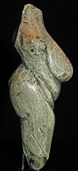
| Montebamboli |
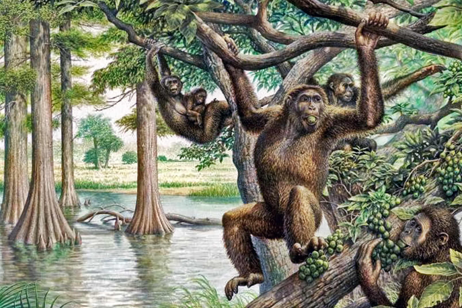 Above, the swamp ape. The long forelimbs are indicative of tree-dwelling. | 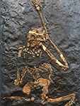
|
It is now believed that the hominid 'Swamp Ape' walked on all fours rather than having a bipedal stance. When Oreopithecus bambolii was alive, Italy formed a string of islands that were covered with swampy forests and teeming with crocodilians, where Tuscany and Sardinia are now. The ape went extinct after a land bridge connected their island to the mainland, allowing large sabre-toothed cats and other predators to stalk the island. See: Oreopithecus bambolii |
| Moravany |
 Moravany is a beautiful place in Slovakia. The Moravany venus is 76 mm tall. The venus was discovered in the area of Moravany nad Váhom, a village near the spa resort Piestany in Slovakia. It is officially dated 22 800 B.P. and belongs to the shouldered points horizon (Willendorf-Kostenkian or upper gravettian). All of the gravettian sites in the Moravany nad Váhom complex belong to Willendorf-Kostenkian. |
|
The Moravany venus was ploughed up in a field sometime in 1938. Later it appeared in Paris. The sculpture was finally returned to Slovakia due to the work of Zotz and Freund, and Dr J Bárta.
Given that the faces of Venus figures are often depicted in a minimalist fashion or obscured in some way, it is possible that the sculpture was created without a head. See: Homo sapiens |
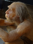
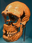
| Neander Valley |
 The Düssel River flows through the Neander Valley. The original Neanderthal skeleton from the Neander Valley consisted of a skull cap, two femora, three bones from the right arm, two from the left arm, part of the left ilium, fragments of a scapula, and ribs. The workers who recovered this material originally thought it to be the remains of a bear. They gave the material to amateur naturalist Johann Carl Fuhlrott, who turned the fossils over to anatomist Hermann Schaaffhausen. The discovery was jointly announced in 1857. The original Neanderthal discovery is now considered the beginning of palaeoanthropology. These and other discoveries led to the idea these remains were from ancient Europeans who had played an important role in modern human origins. The bones of over 400 Neanderthals have been found since. |
|
Kleine Feldhofer Grotte - the Kleine Feldhofer Grotte was a karstic limestone cave and a palaeoanthropologic site in the Neandertal Valley in western Germany. In August 1856, the Neanderthal type specimen was unearthed from the cave. Miners uncovered a skull cap and a number of skeletal bones which were labeled Neanderthal. The bones belong to at least three distinct individuals.
The cave was situated in a limestone gorge with the interior dimensions of 3 m in width by 5 m in length by 3 m in height, with a 1 m opening 20 m above the valley floor in the south wall, which was 50 m high. The cave got its name from the nearby large farm called Feldhof. See: Homo neanderthalensis |
| Nebra |
 The Nebra area, showing the river Unstrut. The Nebra figurines are highly stylised statuettes dating from the late Upper Palaeolithic ( Magdalenian ) and are the oldest known works of art in Saxony-Anhalt. They date from 14 000 - 13 000 BP and were discovered in 1962. The figurines are now in the permanent exhibition at the Vienna National Museum of Prehistory. |
|
The figures were found in the summer of 1962 during an emergency archeology rescue dig at an ancient castle northeast of Nebra. The site was a 120 square metre open air site used by hunters in the late Upper Palaeolithic, 14 000 BP - 13 000 BP, the Magdalenian. The excavators, Volker Toepfer, Helmut Hanitzsch and Dietrich Mania, discovered about sixty pit-like depressions and parts of a light red coloured flagstone pavement on a semi-circular area of 9 m × 3.5 m, where the Stone Age traces had been partly destroyed by a later Bronze Age settlement and a medieval moat. See: Homo sapiens |
| Pech Merle |
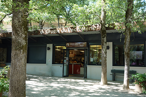 |
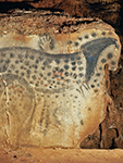
|
Pech Merle was discovered in 1922 by three teenagers, Marthe David, age 13; her brother Andre David, age 16 and Henri Dutetre, age 15. The examination of the paintings and engravings was immediately begun by Father Amédée Lemozi, the priest of Cabrerets. The galleries of the cave are on average 10 m wide and the height of the ceilings is about 5 to 10 m. There are two levels of the cave, but there are only paintings on the first level. 300 m of the walls are painted. See: Homo sapiens |
| Petersfels |
 The Petersfels site, near Engen in Germany. It is one of the most important Palaeolithic sites in Central Europe with an enormous number of important artefacts. It was a settlement site of the Magdalenian (late Upper Paleolithic), with many layers, towards the end of the last ice age, during the period 15 500 BP - 13 500 BP. The main activity here was reindeer hunting in autumn. |
|
At the end of the ice age, reindeer passed through the Bruder Valley every autumn on their way to the snow-free highlands of the Alb. This situation was exploited by the prehistoric hunters, who drove the animals away from their route into side valleys, towards narrow spaces, such as Petersfels. Once cornered, the animals were taken down with a combination of spears, bolas or ropes with wooden hooks, which entangled themselves between the antlers.
Wild horses were also hunted, while smaller game, such as snow hare and white grouse (ptarmigan) were caught with traps. Hunted animals were processed at, or very close to, the site. A brisk wind from the east as well as an annual mean temperature of about 6° C colder than today kept flies and the smell of decomposing animal waste within limits. See: Homo sapiens |
| Pyrenees |
 La Grotte de Niaux is one of the most famous prehistoric caves in Europe. It lies in the northern foothills of the Pyrenees, and is located in Ariège, in the valley of Vicdessos, across the valley from the smaller Grotte de la Vache, in an area rich with prehistoric sites. The huge cave entrance, 55 metres high and 50 metres wide, is at 678 metres above sea level. There are more than two kilometres of galleries, with a hundred or more superb paintings from Magdalenian times, most of which are in the famous 'Salon Noir', 800 metres from the entrance. Many of the paintings are done in the classic style of the Magdalenian, outlined in red or black pigment, mostly haematite or manganese dioxide respectively. La Grotte de la Vache faces south east, and was the residence for the painters of La Grotte de Niaux, just across the valley. It would have been a lovely place to come out of on a sunny day, into the sunshine, even in the middle of winter. Certainly the valley would have kept it shaded very early in the morning in winter, but the sun would soon have swung over the valley walls and down the broad valley to the Grotte de la Vache, even in winter. The inhabitants spent the winter here, feasting on the ibex which came down from their summer pastures in the high peaks and valleys to graze on the broad grassy floor of the Vicdessos valley, and there would have been warm sunshine in the middle of the day. La Grotte du Mas d'Azil is a large, 500 metre long tunnel dug by the Arize River through a wall of the Massif Plantaurelin, part of the Ariege Pyrenees. Secondary caves leading off the main tunnel were occupied at various prehistoric and historic times during a period of 20 000 years, and the objects found there gave the name of the cave to a prehistoric culture, the Azilian. La Grotte des Trois-Frères - the complex system of subterranean passages at Montesquieu-Avantès in the foothills of the central French Pyrenees through which the River Volp flows is conventionally divided into three caves, Le Tuc d'Audoubert to the west, Les Trois-Frères in the centre and Enlène to the east. While the eastern two are connected by a narrow corridor, no usable passage connects Tuc d'Audoubert with Trois-Frères and the only current means of access is by boat. At Tuc d'Audoubert the galleries lie on three levels, the lowest carrying the River Volp, the 'median' with decorated galleries (La Salle Nuptiale, La Galerie des Gravures) and the upper with further decoration (La Chatière, Salle des Talons) terminating in the Salle des Bisons containing the celebrated modelled clay bison. Les Grottes de Gargas have yielded evidence of occupation (bones, stone tools, and portable art) from the Mousterian to the Middle Ages, but it is most famous for its paintings and engravings of the Upper Palaeolithic. The paintings have numerous negative hand stencils made by the stencil technique. The hands are red (ochre) or black (manganese oxide), using a mixture of iron oxide and manganese crushed with animal fat, and sprayed around the hand against the wall. Some have one or more fingers absent which leads to hypotheses of diseases, frostbite and ritual amputation, but most researchers prefer the symbolism of bending one or more fingers. Les Grottes de Marsoulas near Salies (Haute-Garonne), is formed by layers of limestone raised vertically against other layers which then buttress each other. It is the result of a fault. Around 1885, the Abbé Cau-Durban, archaeologist from Ariege, found the floor consisting of carbonaceous ash, animal bones, and worked flint. Patiently he collected many artefacts, the remains of an ice age site. The type of industry and the absence of barbed harpoons led him to believe its relative great age. The cave has since been explored thoroughly, and has revealed paintings and engravings of bison and horses on the walls, as well as artefacts from the ice age, and a huge Triton bailer shell from the sea 300 km away. |
|
Grotte de Bédeilhac has a great diversity of parietal and portal art. There are some truly exquisite examples of carved bone artefacts. The parietal art includes both paintings and engravings – paintings in black and red – and even the use of wet clay as a pigment. The clay on the floor of the cave hardened to form small portable ‘plaquettes’ on which artists engraved individual images of animals. Some of the side galleries are closed to the public, but the main gallery is accessible by guided tour. See: Homo sapiens |
|
There are a number of things about La Grotte de Niaux that are not apparent to most visitors. For example, the artists did not live in the Niaux cave, they lived in the Grotte de la Vache cave, five hundred metres across the valley. Very few actual artefacts have been found in Niaux apart from the paintings. However the Grotte de la Vache is (or was) a treasure house of vital information about the Niaux artists, with many superb pieces of portable art (carved bones especially, but also beautifully crafted stone tools)
See: Homo sapiens |
||
|
La Grotte de la Vache - what is most important is to realise that the hunters (and painters of Niaux) were there right through winter, feasting on the ibex (bouquetin) which came down to the rich pastures in front of the Grotte de la Vache and Niaux, when the mountain pastures of the ibex were under snow. Then in late spring / early summer the hunters went down to the plains to hunt bison and horses and so on, returning in late autumn to again spend winter in the relatively benign environment inside the Grotte de la Vache, which maintained a constant temperature year round of 12 or 13 degrees celsius. Take especial note of the area where they sat in front of the fires, swapping tall stories, feasting, laughing, and preparing hunting tools and pieces of art.
See: Homo sapiens |
||
|
La Grotte du Mas d'Azil was excavated by Edouard Piette in the 19th century, who interpreted the halter-like marks on animal heads as being evidence of the domestication of reindeer and horses. The entry of the Arize which marks the beginning of the cave to the south consists of a 51 m high and 48 m wide hole in the massive limestone wall. A main road, the D119 passes through the central section of the cave. See: Homo sapiens |
||
|
La Grotte des Trois-Frères is famous for its cave paintings. One of these, called 'The Sorcerer' is as familiar as any art in the more famous cave of Lascaux. The cave is part of a single cave-complex with the Tuc d'Audoubert, both galleries formed by the Volp River. The cave art appears to date to approximately 15 000 BP. The cave is named for the three sons of Comte Bégouen who discovered it in 1914. The drawings of the cave were made famous in the publications of the Abbé Henri Breuil.
See: Homo sapiens |
||
|
Les Grottes de Gargas have many figurative engravings depicting horses, bison, aurochs, ibex and mammoth. Carbon-14 dating of a bone stuck in a crack in a wall decorated with hand stencils revealed an age close to 27 000 years BP, indicating that the cave was frequented in the Gravettian period. It is surmised that the hands paintings probably date from this period.
See: Homo sapiens |
||
|
The Great Panel of La Grotte de Marsoulas is very difficult to access, and has been damaged by modern graffiti. 15 000 years ago, it contained beautiful polychrome paintings and dozens of engraved animals. From 2008 to 2009, the facsimile of this ornate wall was replicated. In the studio of Alain Dalis in Montignac (Dordogne), Gilles Tosello did not just reproduce the images in their current state. He proceeded to a real restitution, restoring all the original brilliance to this emblematic tour de force of Magdalenian art. With his companion Carole Fritz, researcher at the CNRS, he studied in detail this composition in the real cave. The completed facsimile was installed at the Prehistory Park of Tarascon-sur-Ariège.
See: Homo sapiens |
||
| Saint-Césaire |
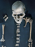
 Saint-Césaire - the exceptional burial exhumed in 1979 in Charente-Maritime combines for the first time an incomplete skeleton of a Neanderthal and the Châtelperronien tool industry dated at about 36 000 years. The individual, perhaps a young woman, showed the scars of a severe cranial injury of traumatic origin, partially healed. The body was completely within a circular area of 70 cm in diameter, probably built intentionally, but no pit has been detected in the search. |
|
The site of Saint-Césaire has delivered numerous flakes and flint tools from different archaeological times: Mousterian, Châtelperronian and Aurignacian.
Because of the fragmentation (more than 500 pieces of bone) and their fragility, the Pierrette skeleton was encased in plaster and removed with accompanying sediment in one block, before being studied in the laboratory. This analysis of the skeleton has revealed the presence of a mosaic of neanderthal characteristics as well as an important healed wound to the head.
See: Homo neanderthalensis |
| Schleswig |
 In the subsequent ice age, the site was located in front of the ice sheet edge. The extremely cold climatic conditions have changed the surface of the artefacts in a characteristic way, giving them a patina they would not otherwise have. Later, after the ice began retreating at around 15 500 BP, Homo sapiens hunters entered the area. The climate became increasingly warm. In front of the receding ice edge, tree-poor, but herbaceous and shrubby grassy steppes formed the habitat for large reindeer and horse herds. They meant life for the hunter groups of the Hamburg culture, followed by the Federmesser and Bromme cultures, who stalked moose. The younger Dryas was the last spell of cold weather of the ice age, and brought deforestation and a tundra landscape, and the Ahrensburg Culture returned to hunting reindeer and horse. |
|
Neanderthals of Schleswig-Holstein - for more than a million years, the hand axe was the most widely used universal device of man. The change in the form and technique of manufacture over the course of the millennia makes it possible to determine the age of these devices. See: Homo neanderthalensis |
|
Hamburg culture - the Hamburg culture or Hamburgian was a Late Upper Paleolithic culture of reindeer hunters in northwestern Europe during the last part of the Weichsel Glaciation beginning during the Bölling interstadial. Sites are found close to the ice caps of the time.
The Hamburg Culture has been characterised by shouldered points and borers, which were also used as burins when working with antler. In later periods tanged Havelte-type points appear, sometimes described as most of all a northwestern phenomenon. See: Homo sapiens |
||
| Spy Cave |
 Spy Cave is located in Belgium above the left bank of the Orneau River. Classified as a premier Heritage site of the Walloon Region, the location ranks among the most significant palaeolithic sites in Europe. The cave consists of numerous small chambers and corridors. |
|
Since the first amateur investigations during the late 19th century numerous amateur and professional archaeologists have carried out excavations and removed all sediment deposits of the cave. The hominin skeletons discovered during the first excavations have been named Spy I, thought to be a female, and Spy 2, a young male. These were dated to around 36 000 BP.
See: Homo neanderthalensis |
| Sungir |
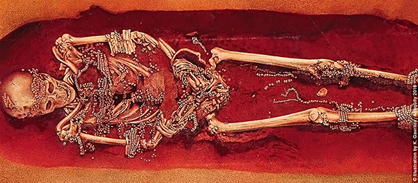 Sungir / Sunghir is a very large early Upper Paleolithic living site located on the outskirts of the city of Vladimir, 192 km from Moscow at 56°08"N 40°24"E. It is a mid Upper Palaeolithic (Eastern Gravettian) cultural accumulation on the left bank of the Kliazma river, of which some 1500 sq. m was excavated in several seasons between 1957 and 1964 The first burial (Grave 1 / Sungir 1) was excavated in 1964. It is that of an adult male in extended, supine position, with his head oriented to the northeast and hands placed over his pubis. |
|
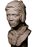
About 28 000 years ago, the residents of the Russian site of Sungir produced thousands of personal ornaments and a number of ivory carvings in geometric and animal forms. Sungir is one of the oldest known cases in which ornaments are actually found on human skeletons. While inhabiting Sungir, at least nine of the site's occupants perished. According to Russian physical anthropologists the best preserved of these consisted of a 60 year-old man, a 7 to 9 year-old girl, a 13 year-old boy, an unsexed (male?), headless adult and an adult female skull. From my reading of the evidence, the adult burial is clearly an older male. The sex of the adolescents remains ambiguous.
In total, the three most intact burials were lavishly decorated with more than 13,000 painstakingly prepared ivory beads arranged in dozens of strands, perhaps basted to their clothing. Although it is almost certain that the three individuals buried intact at Sungir were members of the same social group, there are remarkable differences among them in details of body decoration and grave offerings. For example, the man's forearms and biceps were each decorated with a series of polished mammoth-ivory bracelets (25 in all), some showing traces of black paint. Around his neck, he wore a small, flat schist pendant painted red, but with a small black dot on one side. See: Homo sapiens |
| Swanscombe |
 Swanscombe is one of the many sites in Britain at which Mousterian tools have been found. The Mousterian culture was named after the type site of Le Moustier in France. Similar flintwork has been found all over unglaciated Europe and also the Near East and North Africa. Handaxes, racloirs, and points constitute the industry. Sometimes a Levallois technique or another prepared-core technique was employed in making the flint flakes. |
|
The European Mousterian is the product of Neanderthals. It existed roughly from 160 000 BP to 40 000 BP. Some assemblages include exceptionally small points prepared using the Levallois technique among other prepared core types, causing some researchers to suggest that these flakes take advantage of greater grip strength possessed by Neanderthals. See: Homo neanderthalensis |
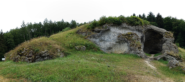
| Szeleta Cave |
 The Szeletian culture is an outgrowth of the Mousterian, similar to the Châtelperronian, an industry with elements of both the Mousterian and the Aurignacian, and is contemporaneous with the Aurignacian. An archaeological culture of the early Upper Palaeolithic (circa 38 000 BP - 28 000 BP.). The Szeletian culture was widespread in what is now Hungary, Czechoslovakia, and southwestern Poland, and its influence can also be seen at a number of places in Romania and Bulgaria. |
|
Named after the Szeleta cave in the Bükk mountain massif in northern Hungary, the Szeletian culture developed mainly from the local Mousterian culture and for a time was contemporaneous with the Aurignacian culture. It was succeeded by the Gravettian cultures. The Szeletian culture is characterised by leaf-shaped, bifacially flaked flint spearheads, Mousterian side-scrapers, and vestiges of the Levalloisian flaking technique.
See: Homo neanderthalensis |
| Ulm |
 As we entered the main town square, I laughed out loud - there was a sea of Löwenmenschen in the square, painted in colours like that of a technicolor dream - or nightmare! It was an art installation, 'Hommage an den Löwenmensch'. The surprise of seeing in multiple, large versions something I had thought of as a little known artefact of the Ice Age had me grinning and shaking my head in disbelief as I looked over them from the cafe window (on the right in this photo) as I had my coffee and cake (no ice cream was available!). It made my day, though every day of that trip was enjoyable and memorable. |
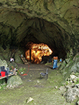
|
Lonetal Sites including Haldenstein, Bockstein (Bockstein-Höhle, Bocksteinloch, Bocksteinschmiede, and Bockstein-Törle), Hohlenstein (Stadel and Bärenhöhle), Vogelherd, and Heidenschmiede, Aurignacian sites in the Swabian Alb near the city of Ulm.
See: Homo sapiens |
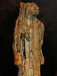
|
Der Löwenmensch was carved from mammoth ivory. It is 30 cm high and 6 cm in diameter. It was found in the cave of Hohlenstein-Stadel in the Valley of Lone, Baden-Wurttemberg (Germany), in 1931, dated as Aurignacian, in a level recently dated to 40 000 BP, making it one of the oldest sculptures known. It is now known to be male. The arms bear striations carved into the ivory. Years after the initial discovery the museum officials were presented with an ivory lion muzzle found in the cave. It was a perfect fit. Today it is pieced together from more than 1000 tiny pieces. This male 'venus' may be an attempt to capture the power of the lion.
See: Homo sapiens |
||
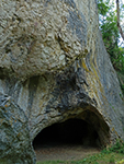
|
Blau and Ach valleys - the Sites of Brillenhöhle, Geißenklösterle, Hohle Fels, Sirgenstein, and other Aurignacian sites in the Swabian Alb, in the Blau and Ach valleys near the city of Ulm.
See: Homo sapiens |
||
| Zaraysk |
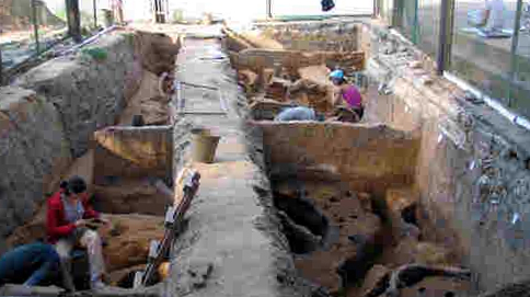 Zaraysk or Zaraisk or Зарайск is part of the Kostenki / Avdeevo group, and is the northenmost example of this culture. The site dates to between 22 000 and 16 000 years ago. The inhabitants were living in a peri-glacial tundra environment, but could call on the rich flint and animal resources of the area at that time. Wood was scarce, but flint, bone and ivory were plentiful, so that raw materials for food, fuel and tools were readily available. |
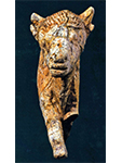
|
The open-air Upper Palaeolithic site of Zaraysk is located in the centre of the town of Zaraysk, about 155 km south of Moscow. The Zaraysk site is the northern most known occurrence of the Kostenki-Avdeevo archaeological culture (Gravettian tradition) on the Russian Plain.
The common feature of Zaraysk and other 'mammoth hunter' sites of Russian Plain is the presence of woolly Mammoth remains, which makes up about 96% of the total number of mammals bones. Among the large Mammoth bones discovered, skulls, lower jaws, ribs and scapulas are the most common. A large number of Mammoth sites demonstrate that this animal was the basic natural resource in various kinds of human activity. See: Homo sapiens |
References
- Berger et al., 2015: Homo naledi, a new species of the genus Homo from the Dinaledi Chamber, South Africa, eLife 2015;4:e09560, DOI: 10.7554/eLife.09560
- Currat M., Excoffier L., 2004: Modern Humans Did Not Admix with Neanderthals during Their Range Expansion into Europe, PLOS Biology, 2 (12): e421. doi:10.1371/journal.pbio.0020421. PMC 532389. PMID 15562317.
- Higham T., 2021: The world before us, Viking, Penguin Random House UK, 320 pp., ISBN 9780241440674.
- Lumley A., 2015: L’homme de Tautavel. Un Homo erectus européen évolué. Homo erectus tautavelensis, L'Anthropologie, Volume 119, Issue 3, June–August 2015, Pages 303-348
- van den Bergh G. et al., 2016: Homo floresiensis-like fossils from the early Middle Pleistocene of Flores, Nature, 534 (7606): 245–248. doi:10.1038/nature17999. PMID 27279221.
Back to Don's Maps
Back to Archaeological Sites