Back to Don's Maps
 Back to Archaeological Sites
Fourneau du Diable
Le rocher du Fourneau-du-Diable, Bourdeilles, Dordogne, France. Vue prise depuis l'ouest.
The rock of Fourneau-du-Diable, Bourdeilles, Dordogne, France. View taken from the west. The site is classified as an historic monument.
Photo: Père Igor
Permission: Creative Commons Attribution-Share Alike 4.0 International license.
Le Fourneau-du-Diable, or Forge-du-Diable, is the name given to a natural rock overhang dominating a prehistoric Upper Palaeolithic site, located in Bourdeilles, in the Dordogne. In particular, sculpted blocks dating from the Solutrean were found there.
Text above: Adapted from Wikipedia
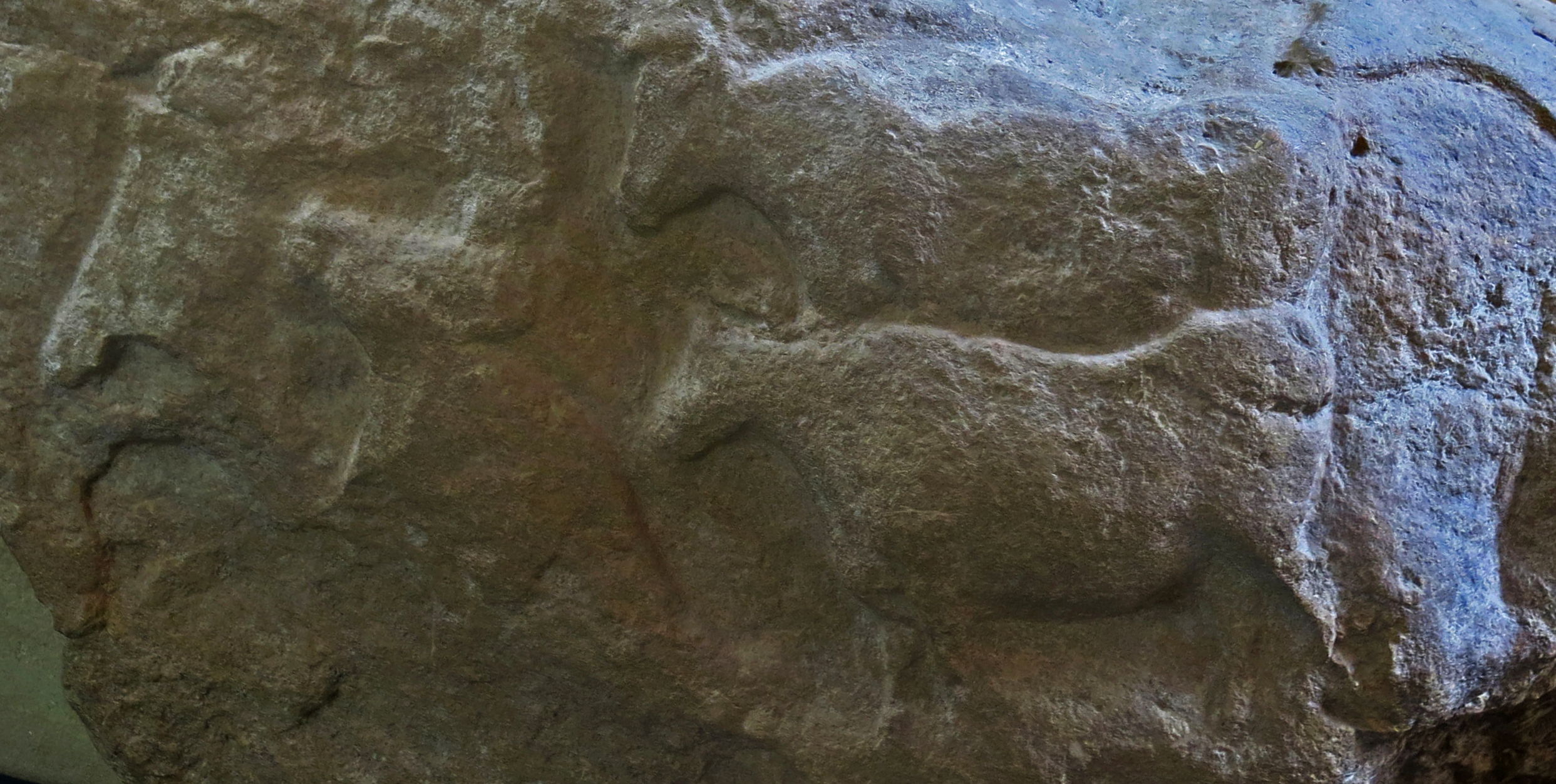
Bas relief carving of aurochs and signs, Fourneau-du-Diable, Bourdeilles, Dordogne
Dimensions: 76 cm x 135 cm x 55 cm.
Photo: Don Hitchcock 2014
Source: Original on display at Le Musée National de Préhistoire, Les Eyzies-de-Tayac
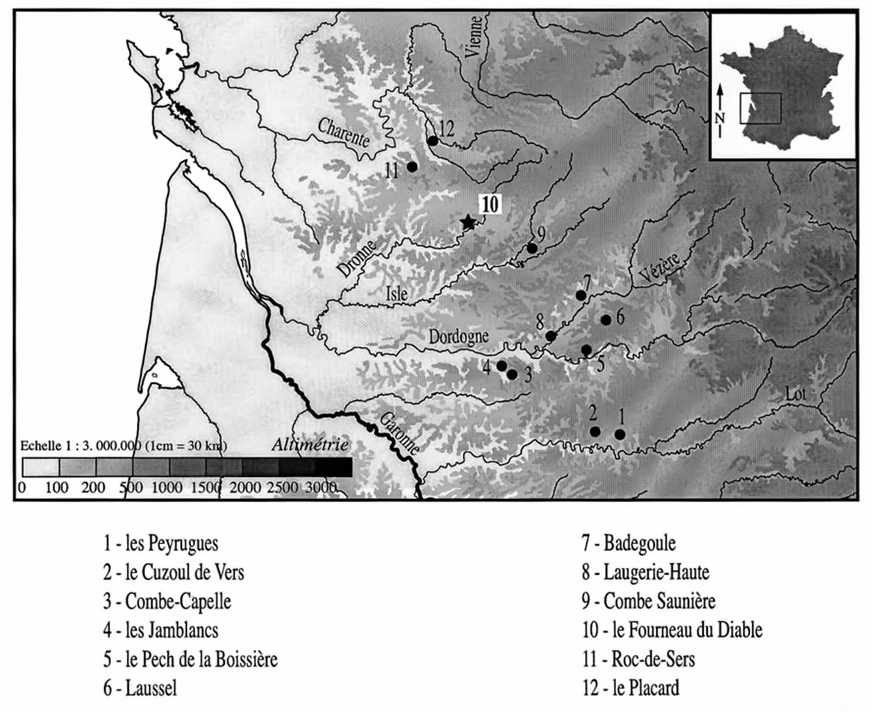
Location map.
Photo: Fontana (2001)
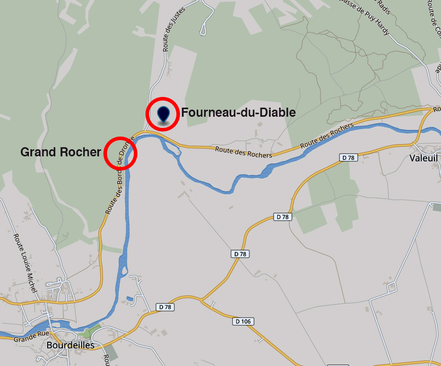
Location of Fourneau-du-Diable and Grand Rocher, Bourdeilles, Dordogne, France.
Photo: Adapted from Google Maps
Le rocher du Fourneau-du-Diable, Bourdeilles, Dordogne, France. Vue prise depuis le sud-ouest.
The rock of Fourneau-du-Diable, Bourdeilles, Dordogne, France. View taken from the south west.
Photo: Père Igor
Permission: Creative Commons Attribution-Share Alike 4.0 International license.
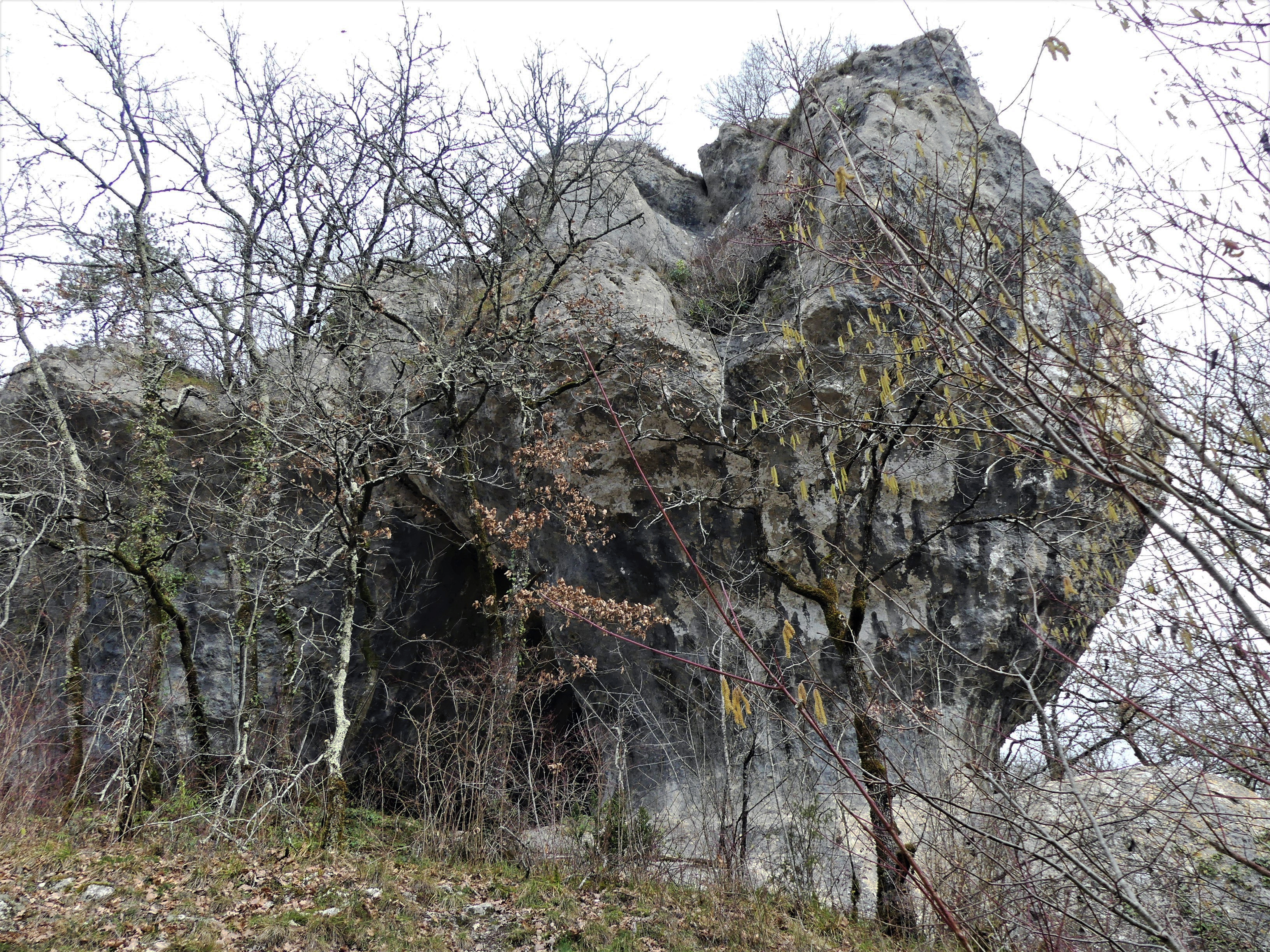
Le rocher du Fourneau-du-Diable, Bourdeilles, Dordogne, France. Vue prise depuis le sud-est.
The rock of Fourneau-du-Diable, Bourdeilles, Dordogne, France. View taken from the south east.
Photo: Père Igor
Permission: Creative Commons Attribution-Share Alike 4.0 International license.
Le rocher du Fourneau-du-Diable, Bourdeilles, Dordogne, France. Vue prise depuis le sud-est.
The rock of Fourneau-du-Diable, Bourdeilles, Dordogne, France. View taken from the south east.
Photo: Père Igor
Permission: Creative Commons Attribution-Share Alike 4.0 International license.
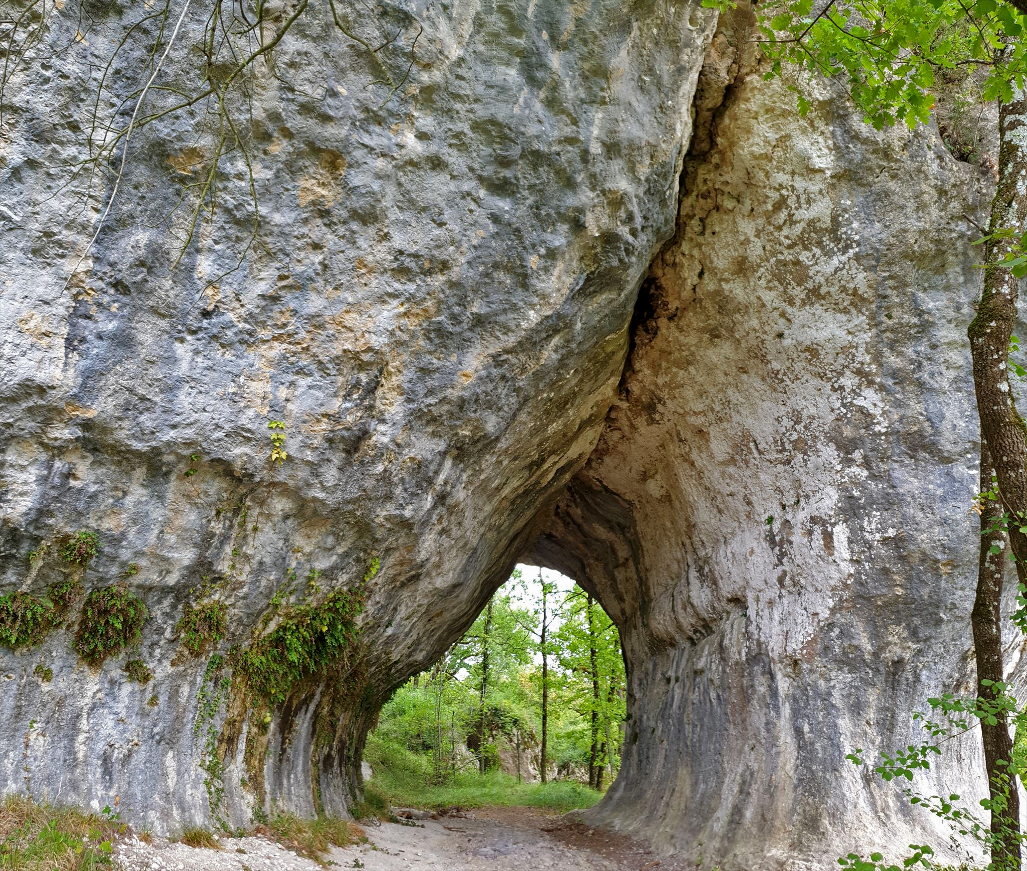
The gisement of Fourneau-du-Diable, Bourdeilles, Dordogne, France, showing what Peyrony (1932) called the 'tunnel' in what is now called the lower corridor. View towards the east, towards the gisement.
Photo: geocaching.com
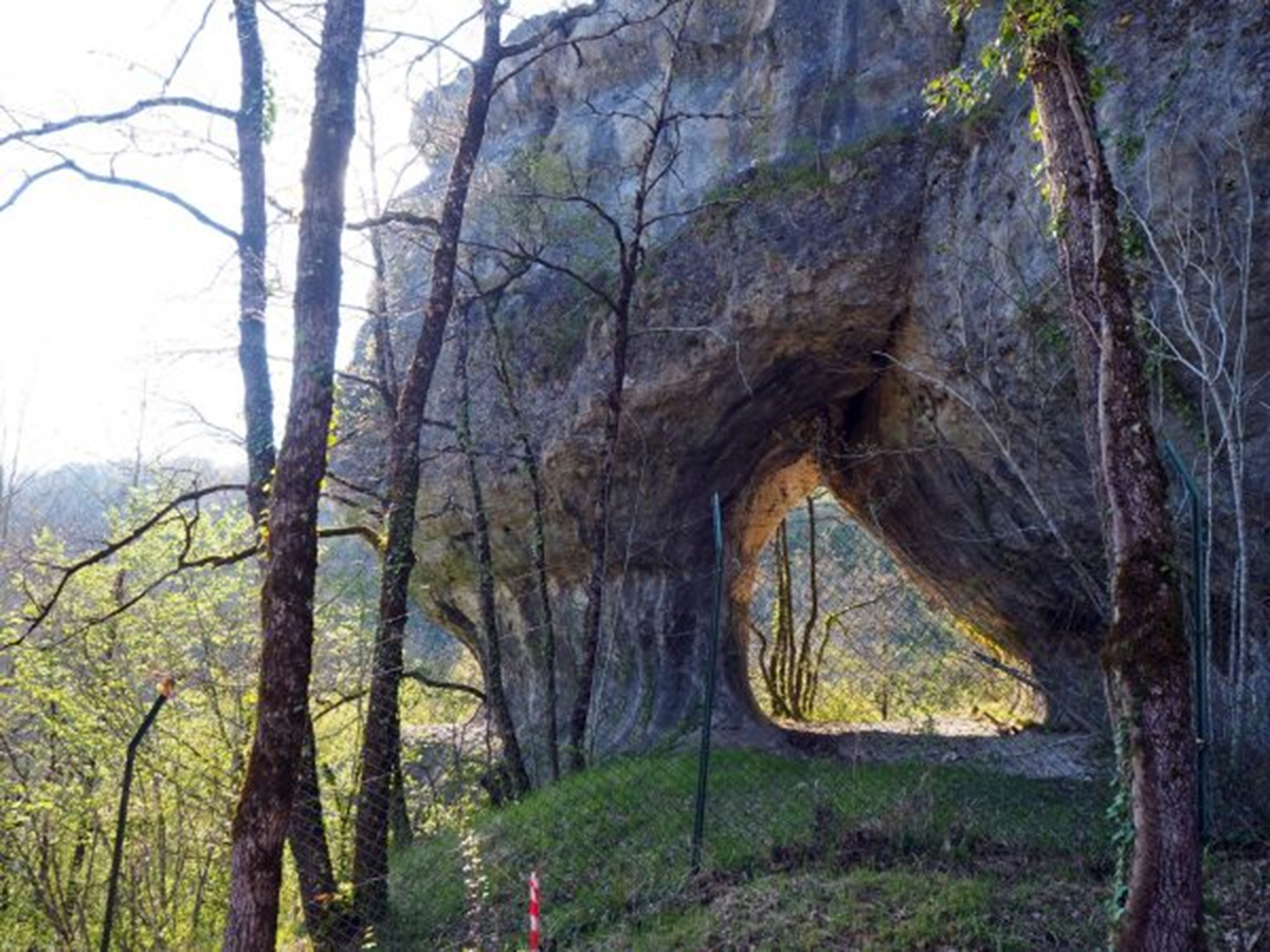
The gisement of Fourneau-du-Diable, Bourdeilles, Dordogne, France, showing what Peyrony (1932) called the 'tunnel' in what is now called the lower corridor. View towards the west, taken from close by the gisement.
Photo: dordognelibre.fr
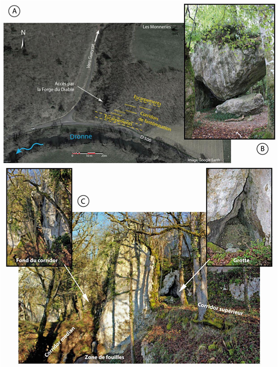
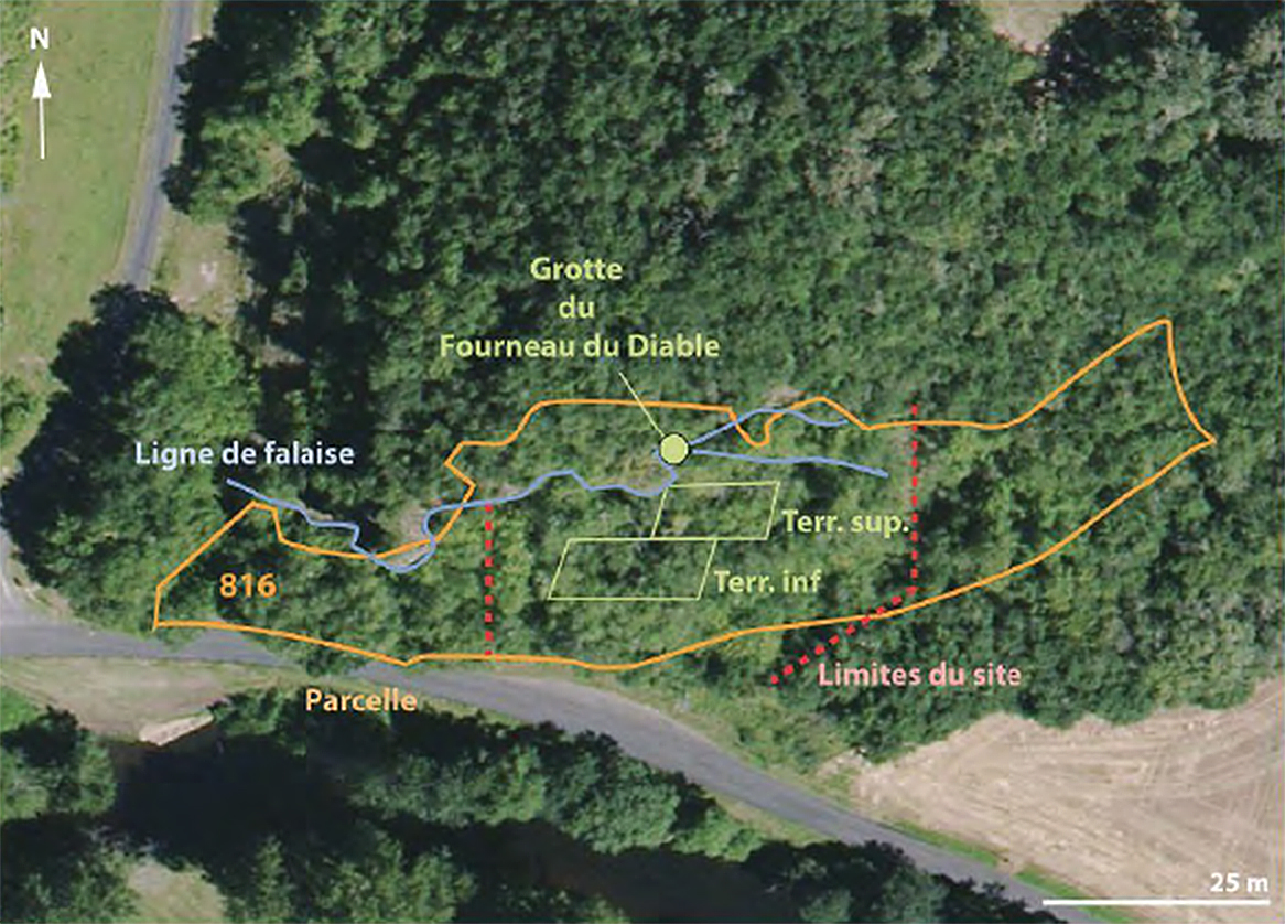
General overview of the site.
A – Location of corridors. The collapse of the pillars led to the opening of the site towards the Dronne and the deposit of substantial scree.
B – Block from a pillar on the edge of a corridor on the banks of the Dronne. The rest of the hallway kept everything in place. Its removal by erosion processes led to the destabilisation of this ensemble and its collapse.
C – Overview of the central part of the site. The upper corridor ends
with a small cavity whose entrance and walls have been modified. The terrace in front of the cavity is made up of relatively loose weathered breccia which was wedged by an arrangement of large blocks. The bottom of the median corridor is covered with various colluvium. The excavated area, in the centre, made it possible to highlight the structure of a wall in the left part of the photograph and the blocks resulting from the collapse of the pillar, visible to the left of the figure.
( I think the figure referred to is a person in white who can be made out just above the words 'Zone de fouilles' in the image - Don )
Photo and text: Baumann et al.(2015)
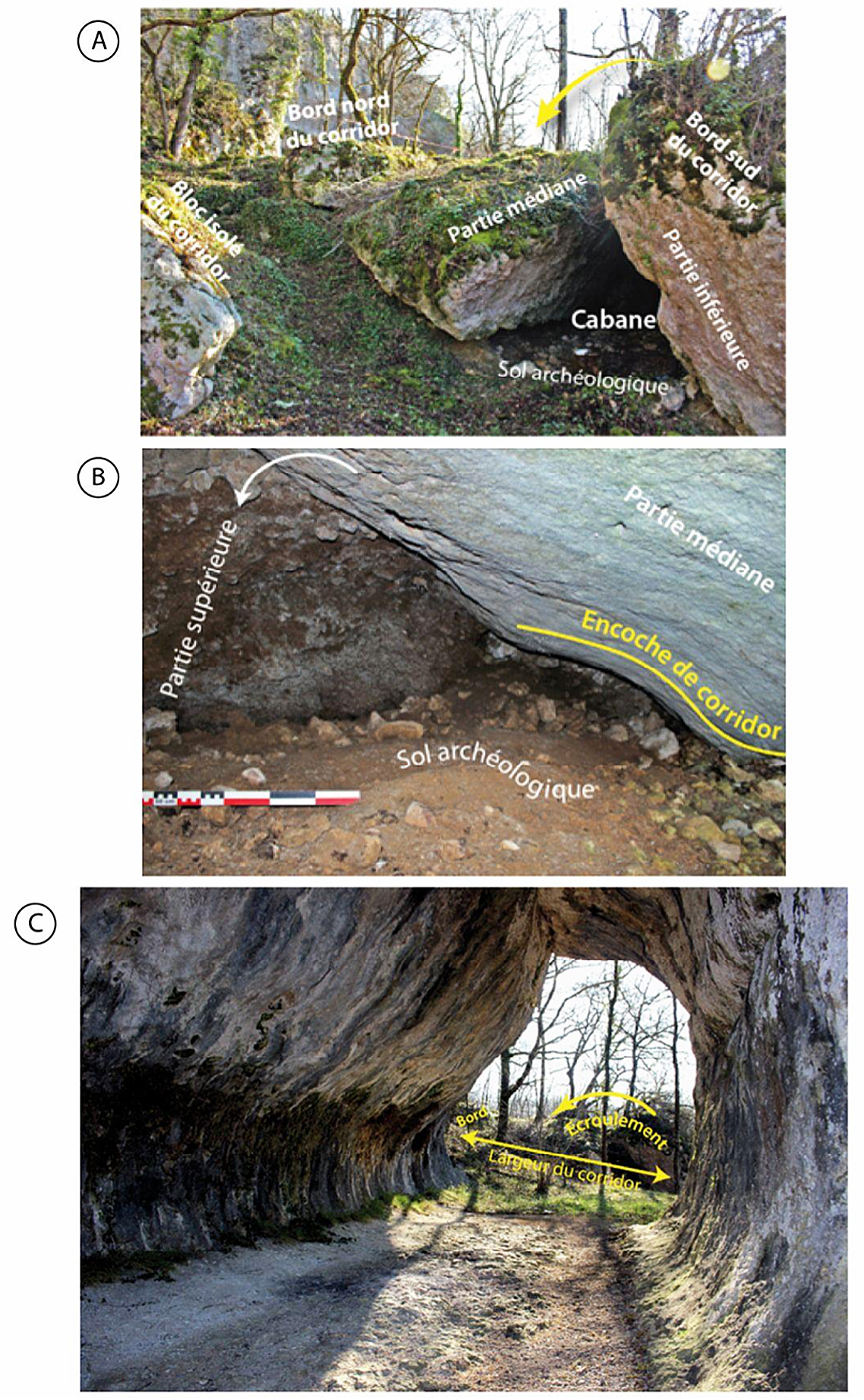
Lower corridor.
A - View towards the east of the southwest part of the excavation area, looking towards the main excavations. The large pinnacle which formed the edge of the corridor tilted towards the north and split into three parts.
The lower and middle parts constitute the Peyrony cabin. This arrangement allowed the preservation of the archaeological deposits. The northern edge of
the corridor is still visible and makes it possible to clearly visualise the surface area available at this location for human occupations and activities.
B - View of the excavation formed by the middle block and the upper part of the pinnacle during the fall. The archaeological deposits have been protected from erosion processes. On the middle part we find the characteristic notches of the walls of the alteration corridors.
C - View from the West of the truncated porch of the Fourneau du Diable. We notice in the background, the collapsed parts of the corridor and the rocks forming the Peyrony cabin. These corridor elements formed a remarkable structural whole in the landscape, conducive to human habitation. The site offered both visibility of the valley and the protection provided by the rocks.
Photo and text: Baumann et al.(2015)
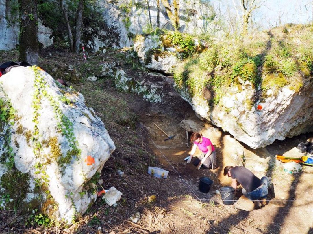
The site is still yielding valuable information, as shown from this photo published in dordognelibre.fr on 24th April 2019.
The researchers are excavating part of the Lower corridor in front of the rock labelled Partie médiane in the image A above this one.
Photo: Maéva Louis, dordognelibre.fr
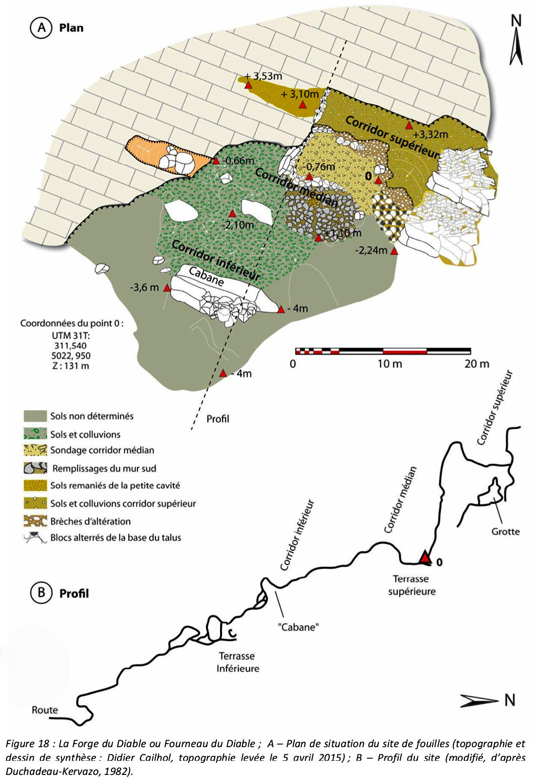
The Devil's Forge or Devil's Furnace
A – Location map of the excavation site.
Topography and summary drawing: Didier Cailhol, topography as at April 5, 2015.
B – Site profile.
Modified from Duchadeau-Kervazo, (1982).
Photo and text: Baumann et al.(2015)
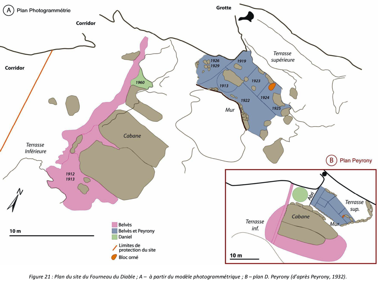
Site plan of the Devil's Forge.
A – from the photogrammetric model.
B – plan D. Peyrony, after Peyrony, (1932).
Photo and text: Baumann et al.(2015)
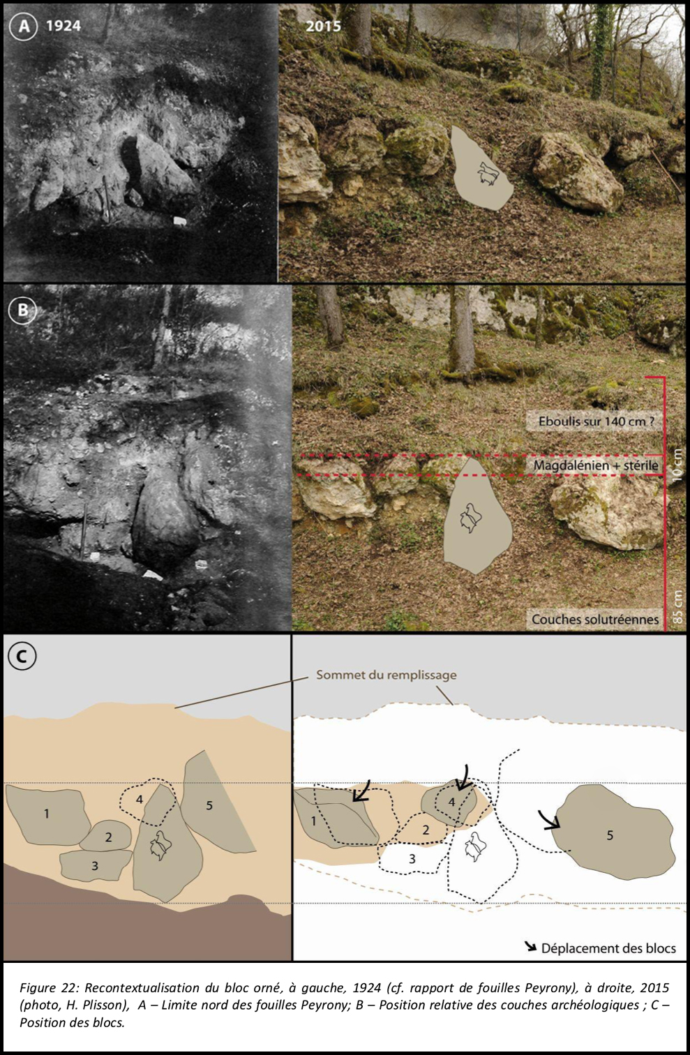
Original position of the decorated block, left, 1924 (see Peyrony excavation report)
Right, 2015 (photo, H. Plisson)
A – Northern limit of the Peyrony excavations
B – Relative position of the archaeological layers
C - Original position of the blocks, and their repositioning in order to remove the decorated block.
Photo and text: Adapted from Baumann et al.(2015)
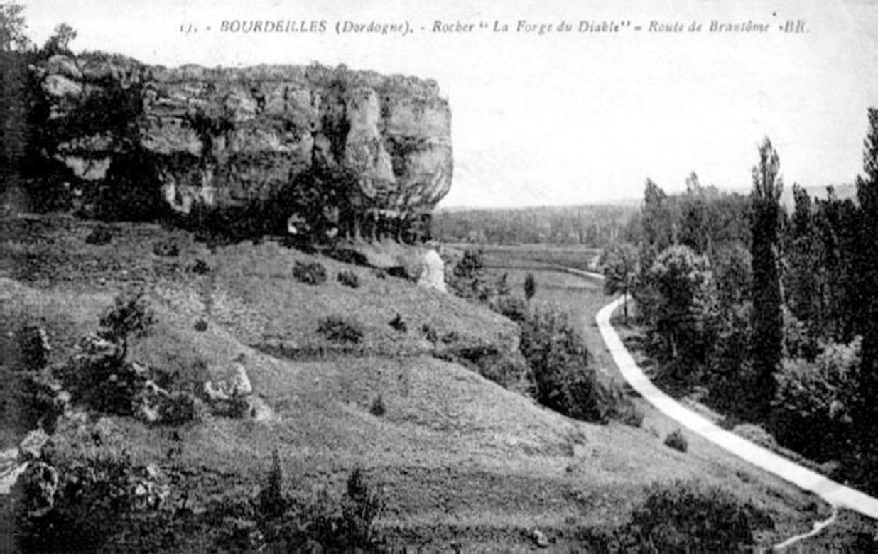
An early 20th century postcard showing a landscape of the Devil's Forge escarpment. The absence of forest cover allows us to clearly understand the morphology of the site with the different pockets of alteration still visible on the walls. Blocks on the ground and colluvium are the result of the evolution of weathering corridors.
Photo: Unknown
Proximal source: Baumann et al.(2015)
Location of the Fourneau du Diable site (Bourdeilles, Dordogne)
Photo and text: Baumann et al.(2015)
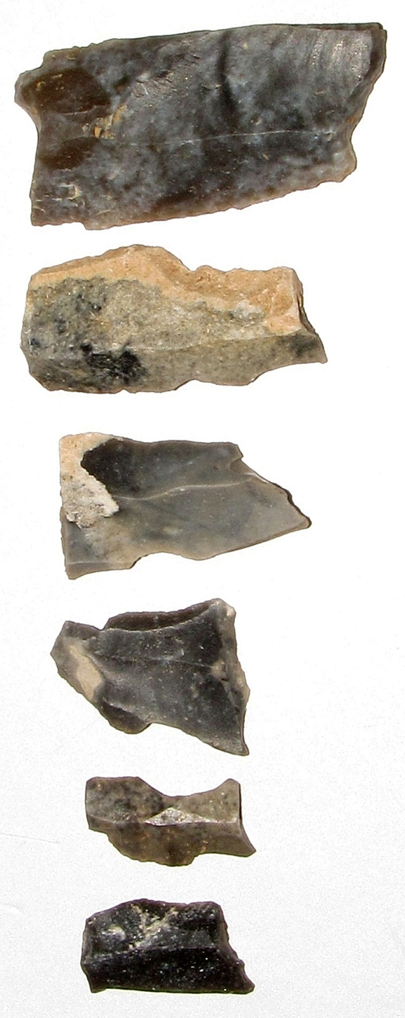
(left)
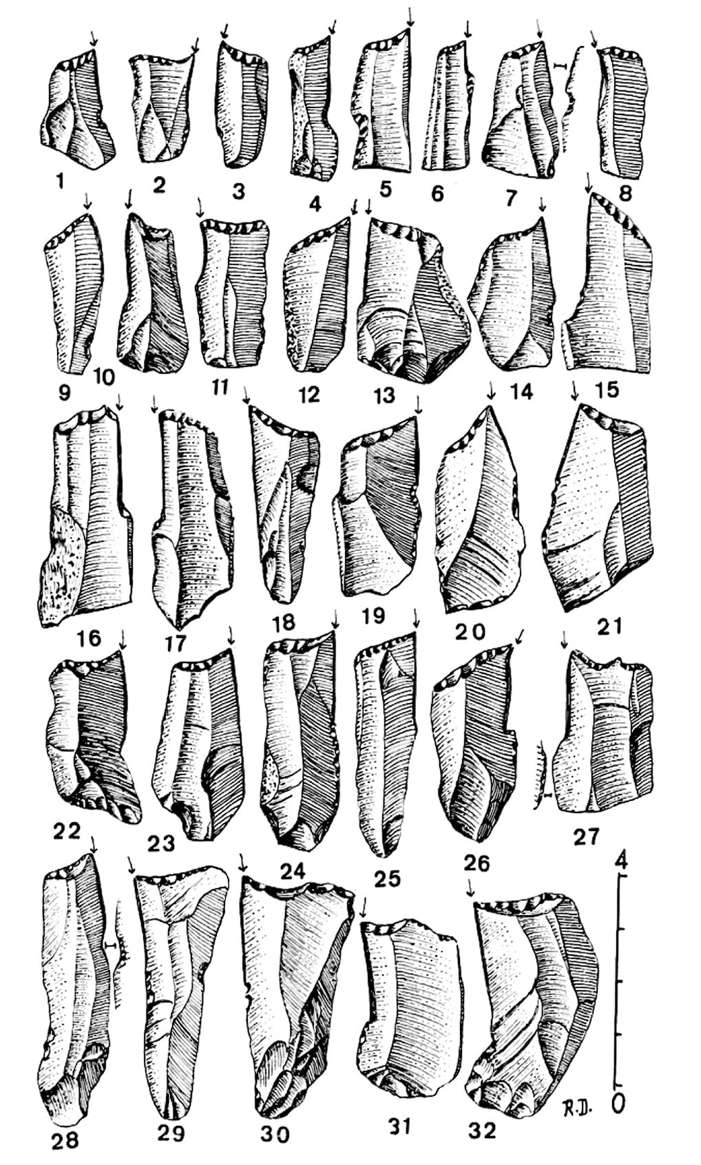
Simple burins de Noailles from Fourneau du Diable.
(right)
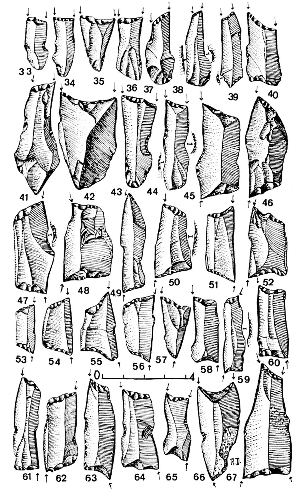
Burins de Noailles from Fourneau du Diable.
33 to 44: burins de Noailles bilatéraux - two burin points side by side at one end of the tool.
45 to 56: burins de Noailles biterminaux adjacents - two burin points at either end of the tool, and on the same side of the tool.
57 to 64: burins de Noailles biterminaux opposés - two burin points at either end of the tool, but diagonally opposite.
65 to 66: burins de Noailles triples - three burin points, two at one end, one at the other.
67: burins de Noailles quadruple - four burin points, two at each end.
Photo and text: Daniel (1969)
This photo of Noailles burins from Fourneau du Diable is from the comprehensive and very useful Aggsbach's Paleolithic Blog.
Photo: http://www.aggsbach.de/2010/09/gravettian-with-noailles-burins/
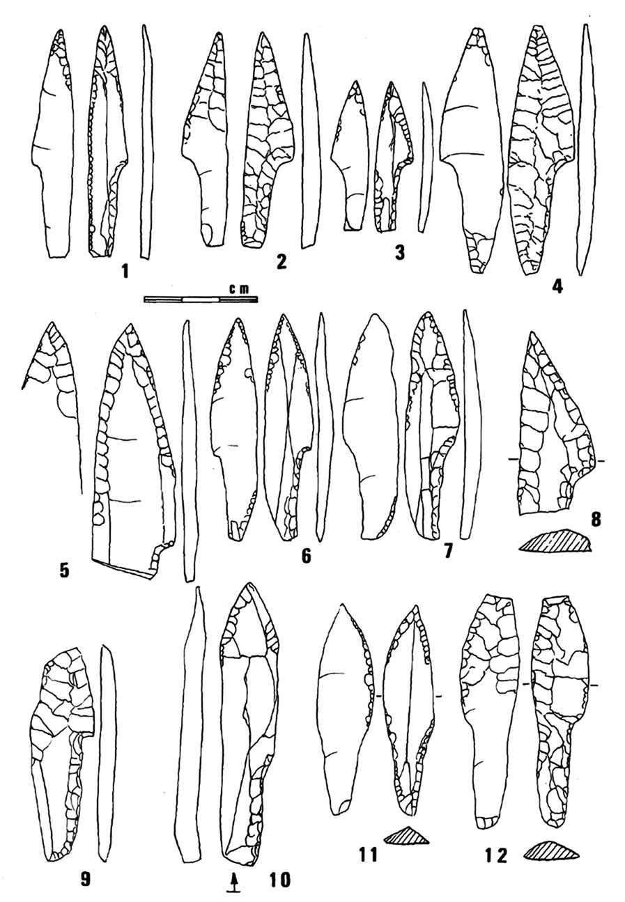
Pointes à cran, shouldered points from Fourneau du Diable, from the collections of Le Musée National de Préhistoire, Les Eyzies-de-Tayac.
1. Type A point, retouched slightly.
2,3,4,6,7. Type A points.
9. Shouldered point broken during fabrication.
10. Large point of the Mediterranean type with abrupt retouch.
11,12. Points shouldered in the Perigordian fashion.
Photo and text: Geneste et Plisson (1989)
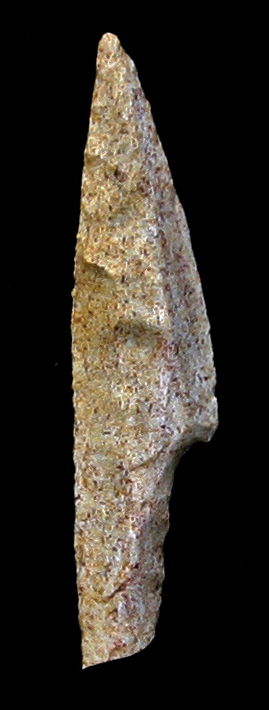
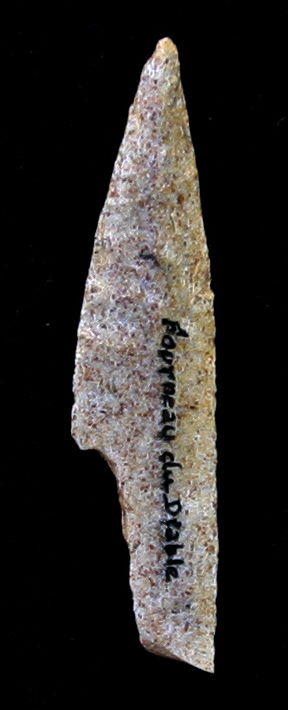
Pointe à cran, shouldered point from Fourneau du Diable.
Photo: http://prehistoirepierresdememoire.over-blog.com/article-pointe-a-cran-du-fourneau-du-diable-116560507.html
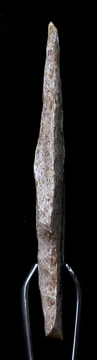
Cave lion tooth with rainurage, a groove carved in the root, in order to use as jewellery, as a pendant, from Fournau du Diable.
Photo: Don Hitchcock 2014
Source: Original, Le Musée National de Préhistoire, Les Eyzies-de-Tayac
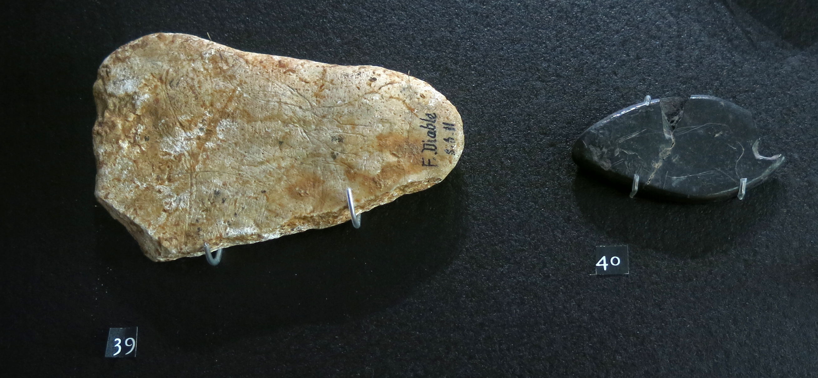
Engraved pebbles from Fournau du Diable.
On the left, an indeterminate engraving, on the right, an engraving of a quadruped.
Photo: Don Hitchcock 2014
Source: Original, Le Musée National de Préhistoire, Les Eyzies-de-Tayac
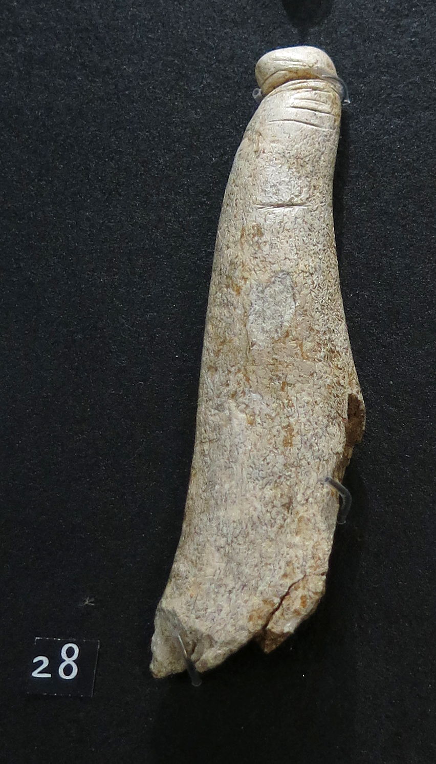
Phallus from Fournau du Diable.
Made of deer antler, this is a relatively small phallus compared with some others, though the one from la Madeleine is of similar size.
Photo: Don Hitchcock 2014
Source: Original, Le Musée National de Préhistoire, Les Eyzies-de-Tayac
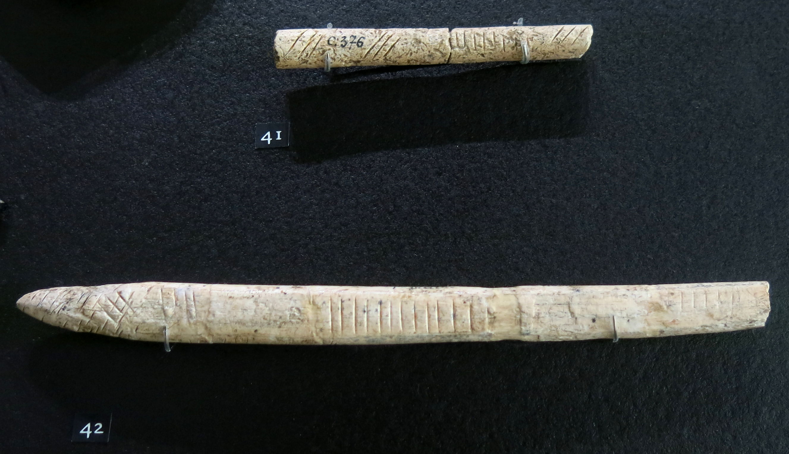
Baguettes demi-ronde from Fournau du Diable.
Photo: Don Hitchcock 2014
Source: Original, Le Musée National de Préhistoire, Les Eyzies-de-Tayac

Carvings from Fournau du Diable.
Photo: Don Hitchcock 2014
Source: Original, Le Musée National de Préhistoire, Les Eyzies-de-Tayac
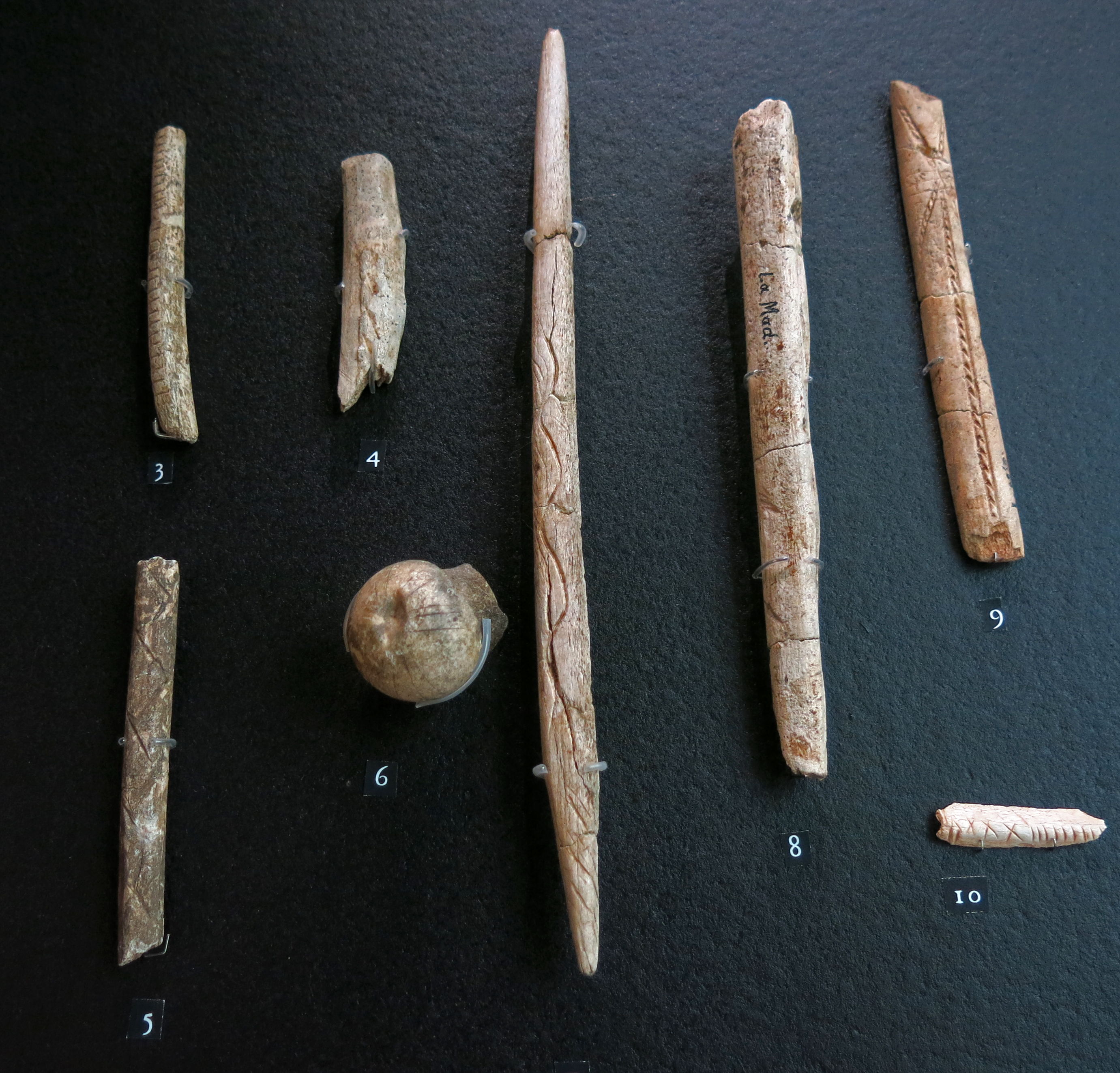
3. Parallel lines, fragment of a rib, Solutrean, Fournau du Diable.
4. Chevrons, La Madeleine, ciseau, middle Magdalenian.
5. Zigzag, Laugerie Haute Est, spear point, middle Magdalenian.
6. Converging lines, Laugerie Haute Est, head of a reindeer femur.
7. Serpentiform lines, La Madeleine, spear point, Upper Magdalenian.
8. Spindle shape, La Madeleine, fragment of antler, Upper Magdalenian.
9. Compound shapes, Laugerie Haute, baguette demi-ronde, Upper Magdalenian.
10. Compound shapes, Castanet, fragment of rib, Aurignacian.
Photo: Don Hitchcock 2014
Source: Original, Le Musée National de Préhistoire, Les Eyzies-de-Tayac
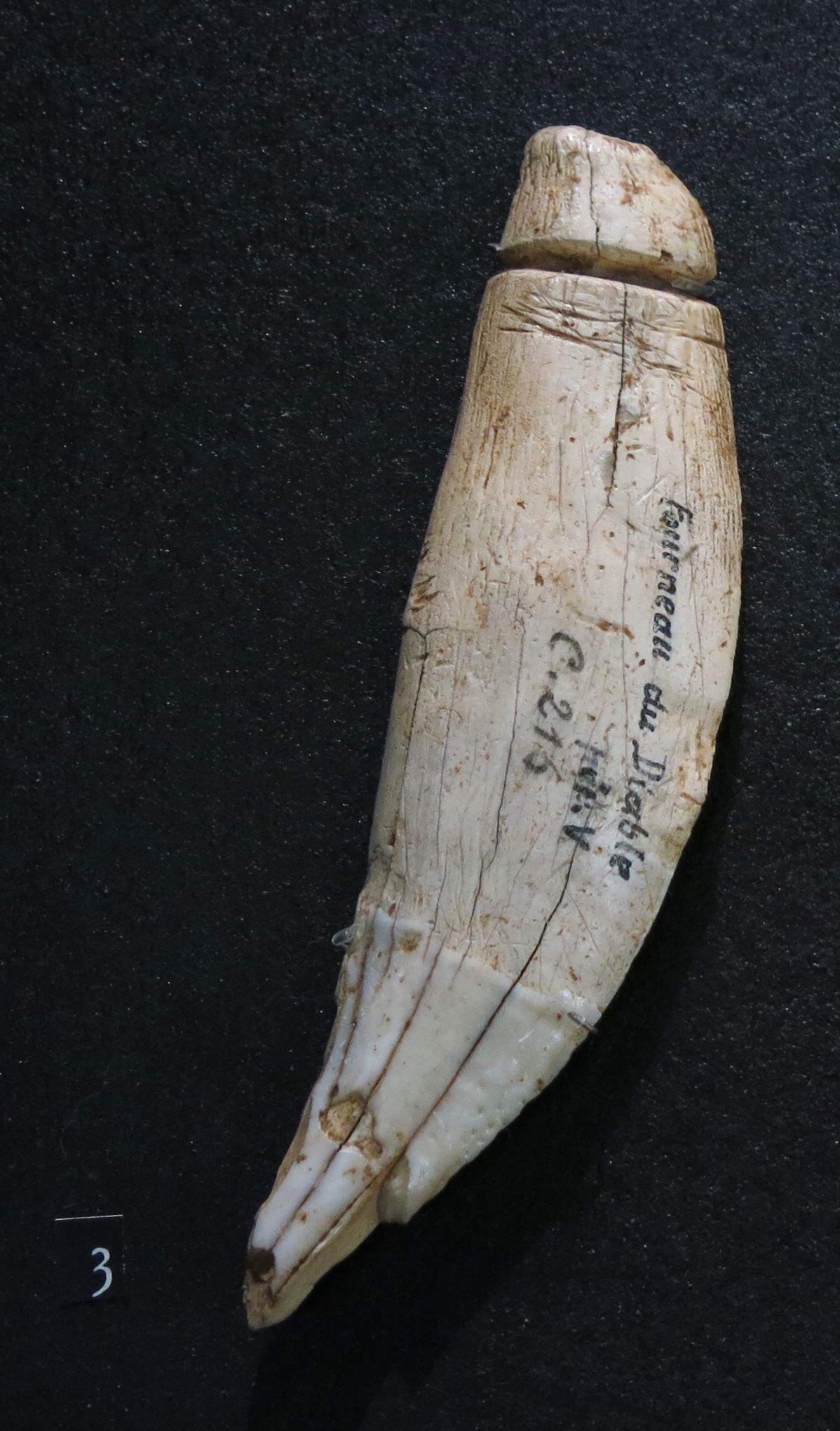
Ivory stopper for a leather water bottle, from Fourneau du Diable.
Photo: Delluc & Delluc (1982)
Reindeer (Rangifer tarandus) were the dominant fauna (70% - 91% of all remains) found at the site, in all the terraces and levels, followed by the horse (Equus caballus) (5% - 20%), and together they formed between 96% and 99% of the fauna.
Other taxa share less than 3% of the fauna, with, for the upper terrace, deer and bovids (i.e. aurochs and bison) being most common in the middle layers, and saiga antelope and the wolf in the upper layers of this terrace.
Text above translated and adapted from Fontana (2001)
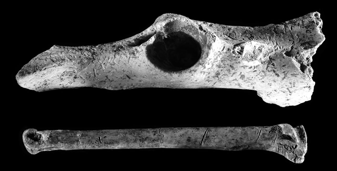
Cut marks of butchery on the metapodial of a hare, and a fox pelvic bone, from the upper terrace, upper stratum.
Photo: Fontana (2001)
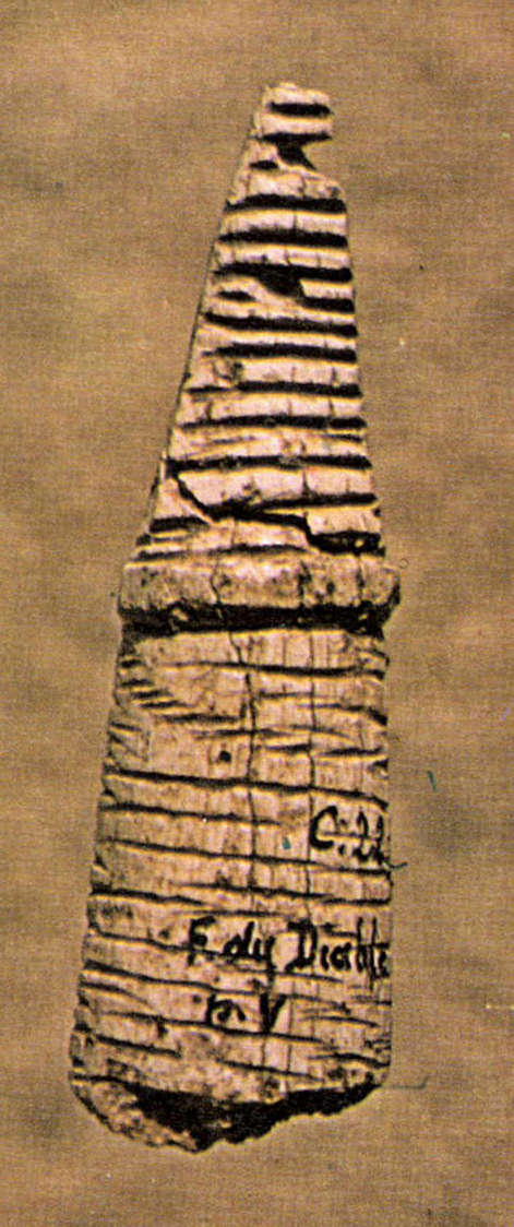
Les reliefs Solutréens du Forneau du Diable, Commune de Bourdeilles, Dordogne.
Translation: Don Hitchcock
However it always seemed surprising that the Solutrean, sandwiched as it was between two rich artistic periods (the Aurignacian and Magdalenian) had not been affected by one or the other, or perhaps both. Our early research at an almost untouched site confirmed our hypothesis, when we discovered reliefs at the Fourneau du Diable lying in the archaeological layer.
This is a short summary of the results of our work and our observations which we have the honour to present.
Topography
Leaving the village of Bourdeilles, we take the bridge over the Dronne, and then take the road to Brantôme, about 200 metres further on, and after 1500 metres, we meet on the left a chain of rocks cut by many small gorges, and on the right a scree line whose feet sometimes bathe in the river bed.
The cliff is riddled with many holes giving access to natural caves, some occupied during the Palaeolithic era, but surely all in historic times, as evidenced by the many modifications at the top that have made the walls more useful. It also forms several abris or rock shelters, in which were discovered more or less large hearths of primitive men. Almost at the east end, a deep valley up towards the hamlet of Moneries, is partitioned into two unequal sections. It is in the smallest of these, called the Forge, or Forneau du Diable, that we found the deposits containing the sculptures.
At this point, the rocks form an arc whose interior opens to the east and south. On the steep slope 40 meters in height, there are numerous boulders of all sizes, probably from the collapse of the roof of a very large shelter.
Archaeological sites
Two natural terraces occur on the hillside, one half way up, the other at the top, near the cliff. The first is occupied by an old Aurignacian deposit directly overlain by a Solutrean horizon. Everything is covered with large limestone blocks, two of which are ten metres long each, inclined towards each other, supporting each other, and forming a sort of large hut where it was possible to undertake some fruitful research . The investigations also focused on the open space located downstream. As for the parts directly under the huge rocks, we had to abandon them.
The excavations, begun in 1919 on the second terrace have continued every year since our late friend and collaborator Belvès revealed a purely Solutrean deposit. The work showed that the archaeological layers butted up to the east against a line of scree, intentionally placed there, it seems, and, to the south, against a mortarless wall made of larger and rounder stones. A 420 cm entrance was left in the southeast corner.
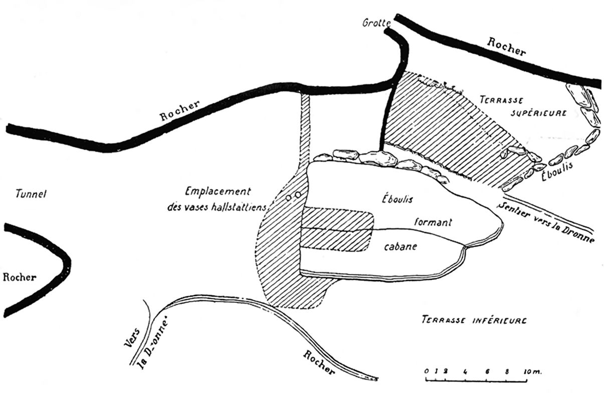
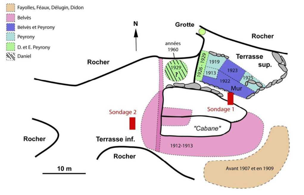
Map of the site.
Photo: Peyrony (1932)
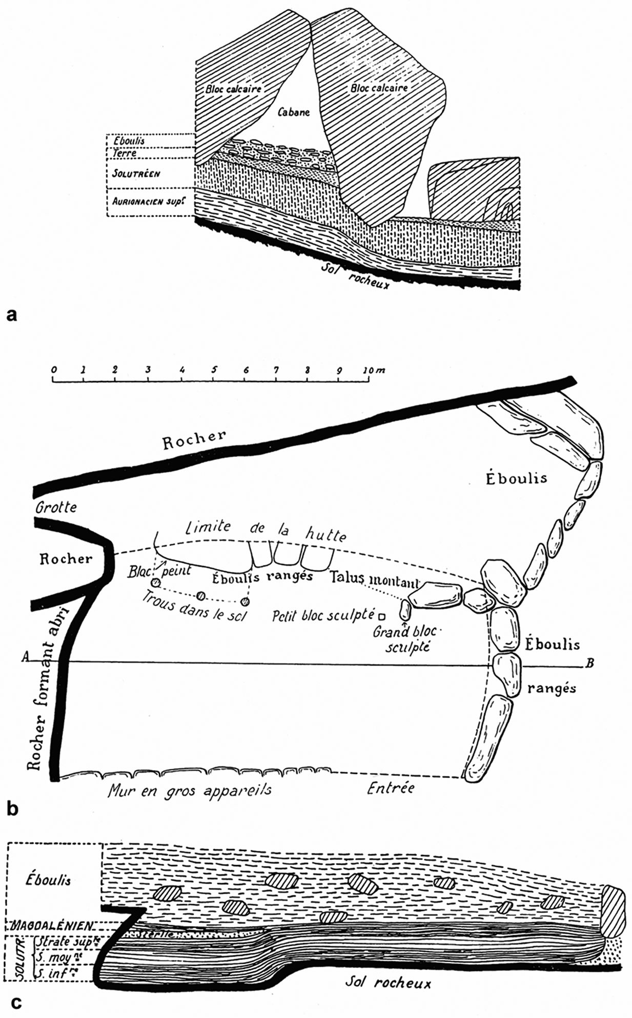
a. Stratigraphic profile of the lower terrace deposits
b. Map of the upper terrace
c. Stratigraphic profile of the upper terrace deposits
Photo: Peyrony (1932)

Stratigraphic profile of the upper terrace deposits, a more detailed drawing by Peyrony.
Photo: https://www.nespos.org/display/PublicNesposSpace/Fourneau-du-Diable
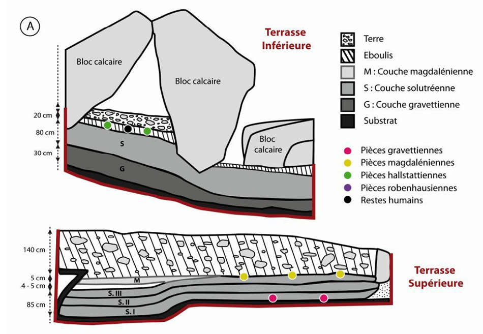
Stratigraphy of the upper and lower terraces.
Note that Hallstattian refers to the Late Bronze Age, and Robenhausen to the Neolithic, however there are no Robenhausen pieces marked on the diagram.
Photo and text: Baumann et al.(2015)
Areas targeted for the 2015 survey based on data collected from old excavations (map modified from Peyrony (1932).
Photo and text: Baumann et al.(2015)
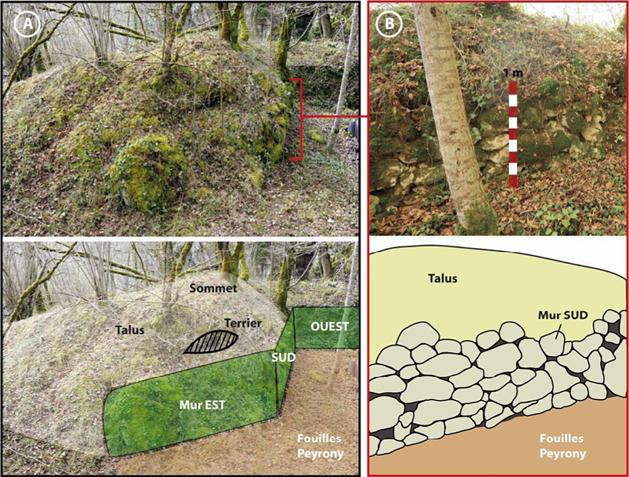
Upper terrace, 2015: A – 'Wall' and 'embankment' under the vegetation; B – Detail of the construction wall.
Photo and text: Baumann et al.(2015)
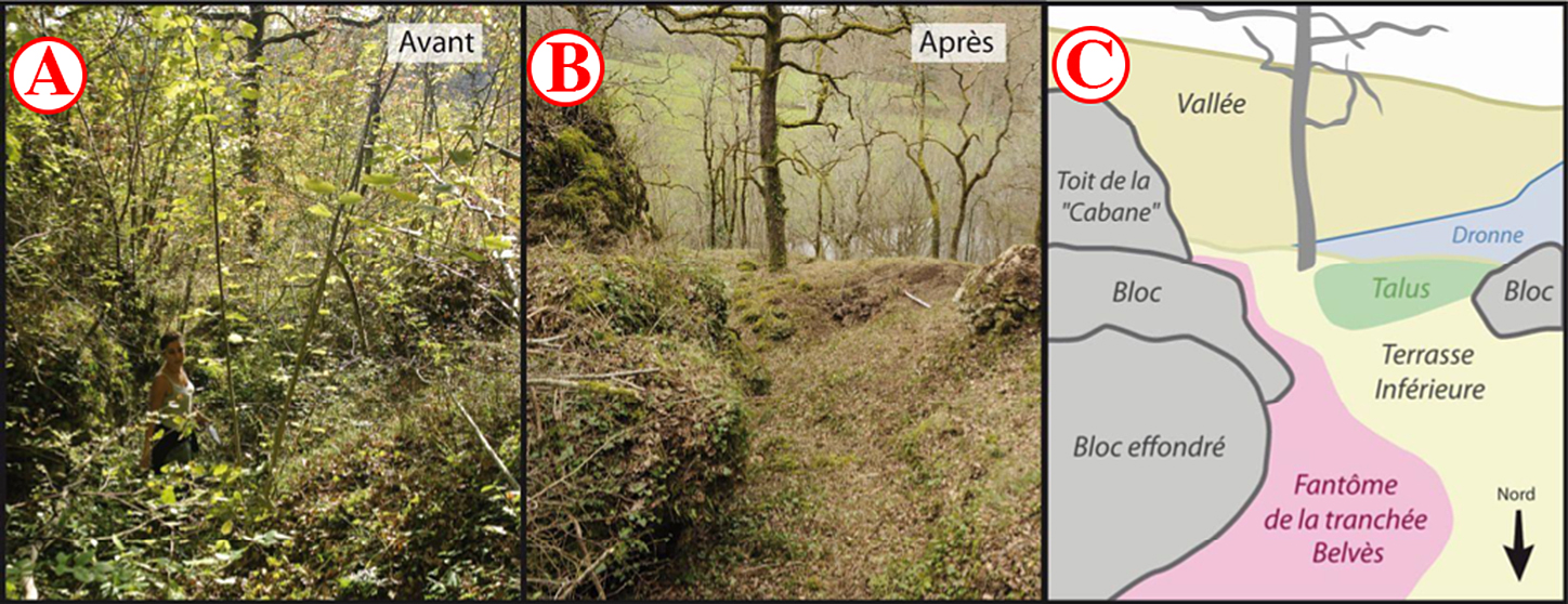
Lower terrace, 2015: A – Before clearing; B – After clearing; VS - Uncovering the main elements of the landscape.
This cleaning was a necessary preliminary to the excavations, but also to the realisation of a modelling of the site by photogrammetry, the first stage of a recording of the topography of the site.
Drawing text:
Roof of the 'Cabin'
Block
Fallen block
Valley
Remains of the Belvès trench
River Dronne
Talus slope
Block
Lower Terrace
North
Photo and text: Baumann et al.(2015)
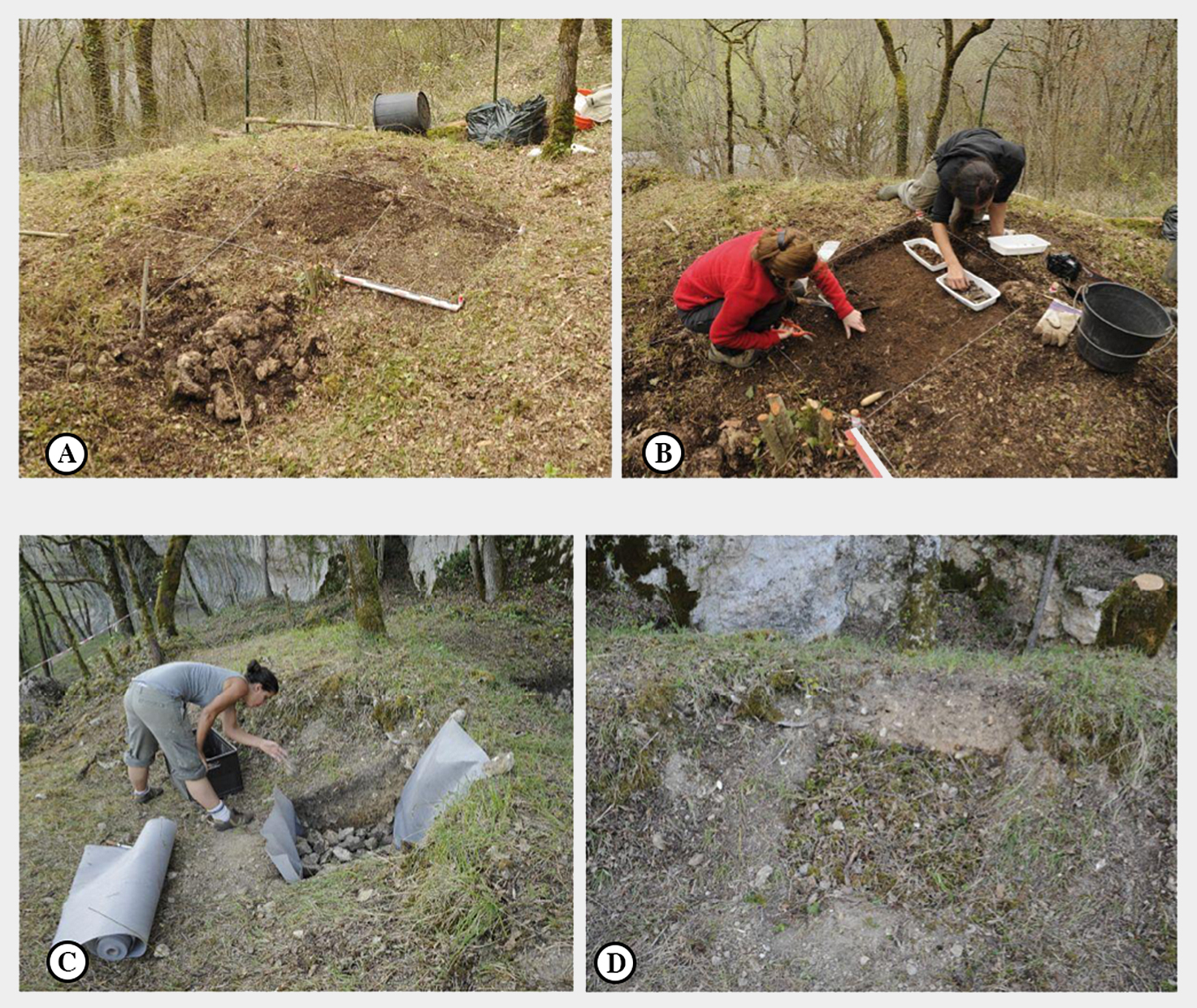
Sondages, 2015:
Excavation and filling of the sondages; A – Location of the sondage, lower terrace; B – Excavation, Lower Terrace; C and D – Refilling, Upper terrace.
( Note that the sondages were filled in using a method which would ensure that future excavators would be aware of their history. The walls and the bottom of each sondage was covered with geotextile and the whole filled with limestone fragments from the excavation, and pieces of wood from cleaning of the area.
- Don )
Photo and text: Baumann et al.(2015)
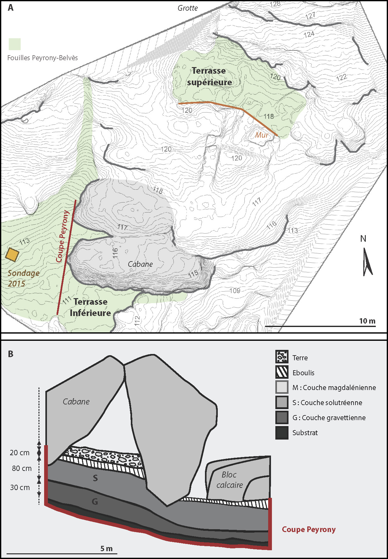
This is a valuable redrawing of the Fourneau du Diable site, from a recent paper.
A: Site map in 2015 and excavated areas
B: Stratigraphic section of the lower terrace, after Peyrony (1932)
Photo: Vignoles et al. (2019)
The excavation is not advanced enough to say whether there is a similar wall to the West, but it is possible. So there would have been at this place a small area limited to the north by the cliff, and on the other three sides by a wall of large irregular rocks. Human deposits were met everywhere, but with variations in thickness ranging from 145 to 170 cm. It was possible to distinguish three layers, all belonging to the upper Solutrean, but distinguished by their colour.
The base layer, yellowish, contains long (one was 22 cm in length!) 'laurel leaf' spear points and a few points with barely indicated shoulders having been knapped on them (pointes à cran). The second layer, reddish, had 'laurel leaf' points which were of medium and narrow width, but thin and finely worked, with some better defined shouldered points. Finally, the third, topmost layer, dark, with more elongated spear heads called 'willow leaf' points, as well as shouldered points with barbs. All three levels gave a fairly varied bone industry which will be described in the general conclusions. The fauna is characterised by the predominance of reindeer, followed by horses and aurochs.
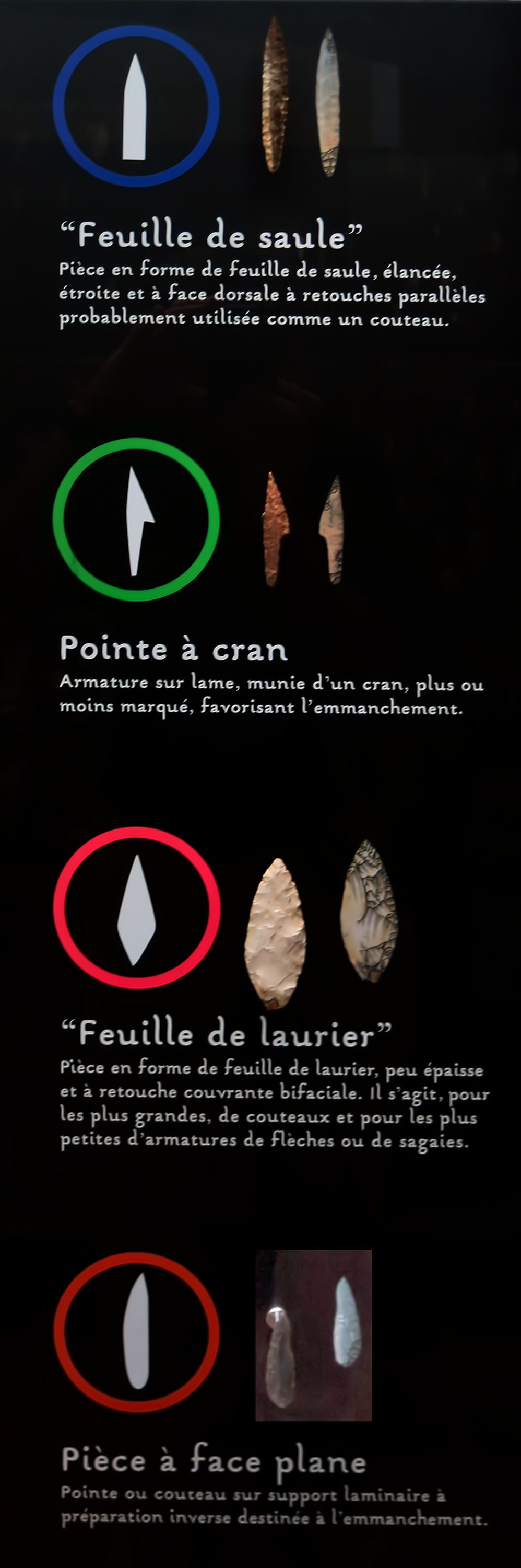
Definitions and illustrations of various points.
Photo: Don Hitchcock 2014
Source: Display at Le Musée National de Préhistoire, Les Eyzies-de-Tayac
So far as the industries go, this deposit belongs to the Solutrean era. However, during the work performed by one of us (Peyrony), a fine parrot beak burin was found in the upper level, and later the head of a second. We know that these tools are usually found only in the Magdalenian, although they appear sporadically in the Aurignacian.
Discovery of the reliefs
Last September, during an inspection trip, one of us (Peyrony), having walked through all the excavated area in every direction, found that nothing had changed since his last visit, began to carefully examine some large limestone blocks put to one side during the last excavations.
This work gave him no results and he was about to leave when his gaze fell on a big boulder emerging partly from the archaeological layer. It was completely covered with a thick limestone crust, except on a very limited area washed clean by rainwater. He noticed on this part a deep furrow covered by an earthy deposit. Using a pointed stick, he cleaned this furrow, following all its changes of direction. Finally, he had returned to his starting point, a process which revealed the outlines of a superb aurochs. He stopped his work, hid the block, and waited for instructions with regard to its extraction. The removal took place on the 10th December last, and led to the discovery of a second aurochs, also carved into the block, but much smaller.
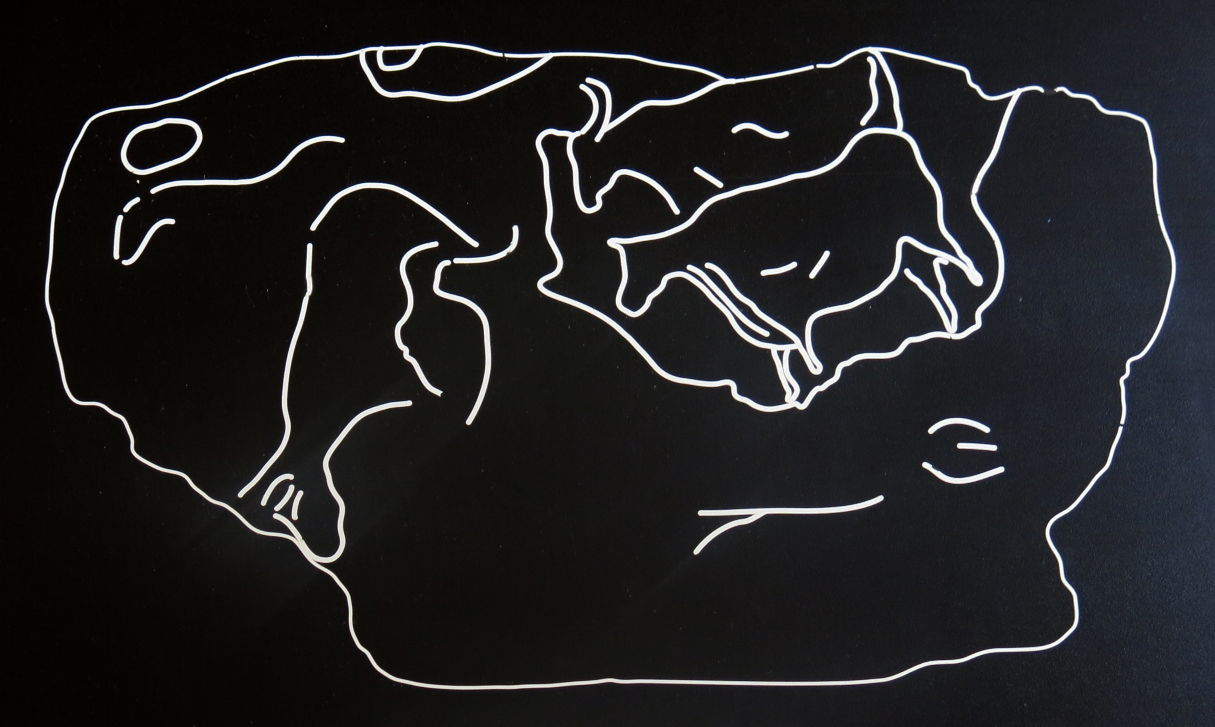
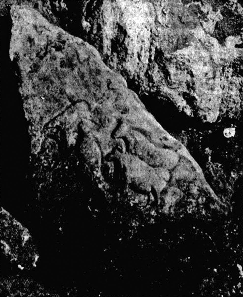
Sketch of bas relief carving of aurochs and signs, Fourneau-du-Diable, Bourdeilles, Dordogne.
Rephotography: Don Hitchcock 2014
Source: Poster on display at Le Musée National de Préhistoire, Les Eyzies-de-Tayac
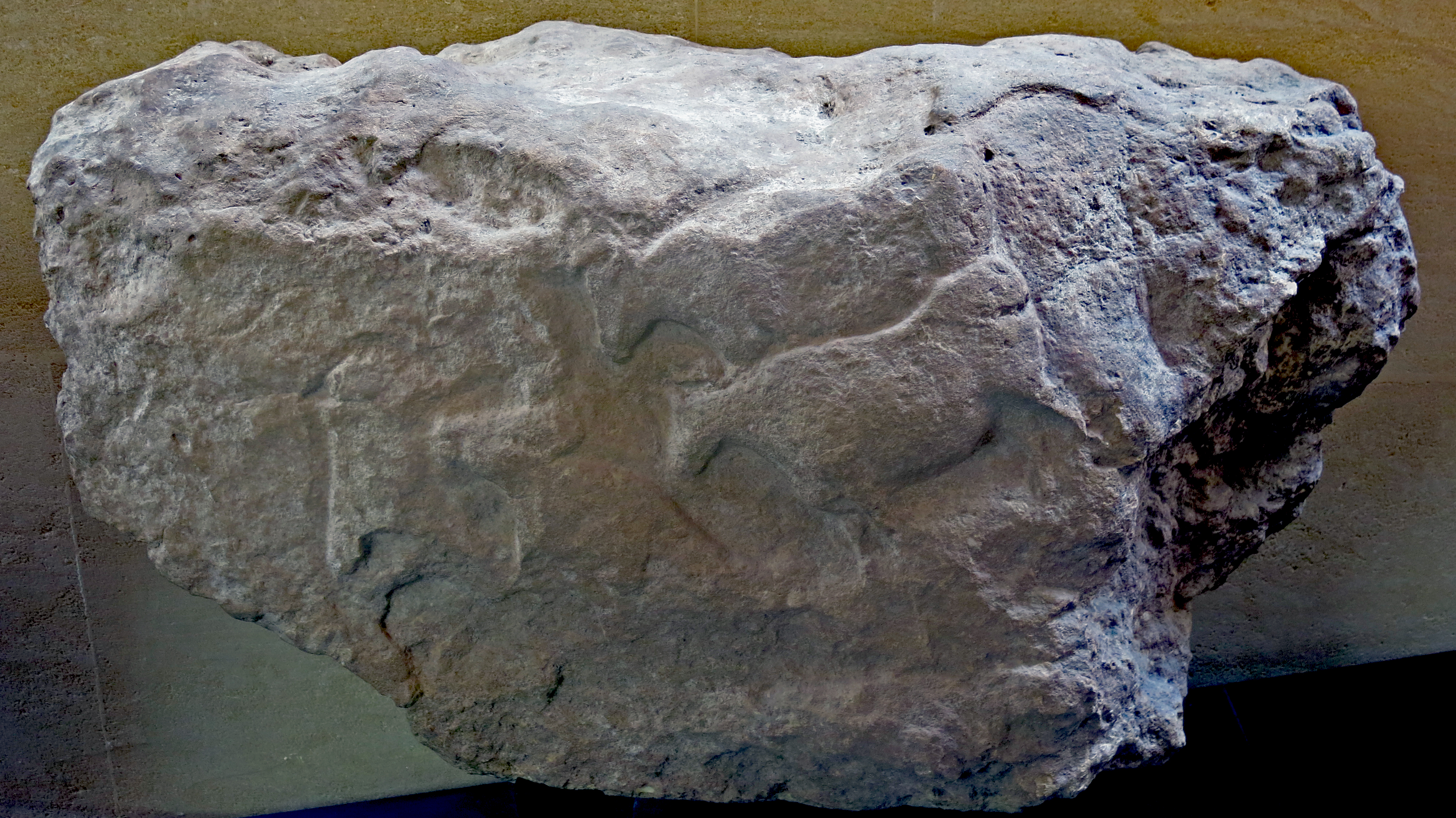
Bas relief carving of aurochs and signs, Fourneau-du-Diable, Bourdeilles, Dordogne.
Upper Solutrean, circa 22 000 BP.
This image shows the complete stone.
Dimensions: 76 cm x 135 cm x 55 cm.
Photo: Don Hitchcock 2014
Source: Original on display at Le Musée National de Préhistoire, Les Eyzies-de-Tayac
The location of the carved blocks
The largest of the blocks, the first discovered, had the form of an irregular triangular pyramid. It was placed facing to the front, and 450 cm behind the entry to the small enclosure, and 200 cm from the Eastern wall. It had a volume of about half a cubic metre. It lay on the 30 cm archaeological layer, the early phase of the upper Solutrean, inclined at 45° on one of the faces, following the north-south direction, with the base towards the south. The pressure of the materials that had covered it had broken the exterior angle of the base.
Both decorated sides were turned towards the east, the third to the west, the latter much more straightened. It was wedged underneath by three stones, with two sitting on the third, which kept it in this oblique position relative to the ground surface of the local area. One of these stones had a surface worn into a bowl shape, indicating that it had been used for some purpose. To the east, it leant on a massive rock entirely covering the two lower archaeological layers.
The decorated block in situ.
Photo: Capitan et Peyrony (1925)
The carved stone therefore appeared to have been placed there, either simultaneously or subsequently to the latter. It could only be the work of the last inhabitants, from the final Solutrean. It is possible that in seating the stone, it had been dug a little into the ground, but it is clear to anyone that its situation marks the last layer of the occupancy phase.
It was found by us, as well as MM le marquis de Fayolles, curator of the Perigord Museum, Féaux, assistant curator, and L. Didon, archaeologist. The second block lay completely within the layer, 80 cm to the left. It was on the same basic level as the previous one, but but unlike the latter, it was completely covered by the top layer. It was therefore part of the earliest phase or the middle phase, that is to say, earlier than the other horizon.
Description of the drawings
The reliefs of this last (small) block consist of two twin rough heads arranged in opposite directions, side by side with separate necklines. They were carried out by the use of natural rock formations combined with the digging of artificially large superficial grooves and sometimes a deeply worked champlevé. (The champlevé style consists of carving a broad channel outside the initial outline of the animal, creating an effect of bas relief - Don ) It is exactly the mode of such carvings during the Aurignacian. The left head has two different aspects attributed to it according to one of the two existing muzzles.
One of them, elongated like the snout of a boar, reaches the edge of the stone. That of the other, shorter and thicker, has the nostril, mouth and chin indicated by regular incisions. The eye, forehead, the top of the head, part of the lower jaw and chest (the latter two strongly protruding) they have in common. The top of the head, formed by the upper edge of the block, is connected by a light engraved line to the one on the right, appearing to correspond to a horn.
As with the first, the forehead and muzzle coincide with the natural contours of the stone, an existing hole in its proper place marks the eye, while a sort of goatee beard, lower jaw and chest are highlighted and defined by the outline of a wide groove. A similar engraved line separates the two necklines. The age of these engravings does not make it easy to identify them. The one on the right, which has curved horns and a beard, seems to be a goat. It is more difficult to identify the other. One could see a wild boar or a bear.
This rough work only supports the parallel with some that we have discovered in the middle Aurignacian of La Ferrassie: the same design, the same composition, the same execution, the same primitive characteristics. Placed next to each other, it would be difficult, if not impossible, for even an informed observer, to distinguish!
The other block, larger, was halved in size without damaging the decoration, to be transported to the Musée préhistorique des Eyzies where it is now installed.
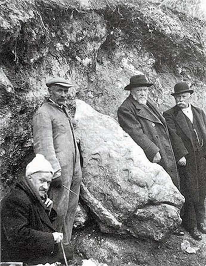
The decorated block, surrounded by members of the Archaeological and Historical Society of Perigord, two months after its discovery, photo taken on 12th December 1924. Denis Peyrony second from left, beside the block.
The block had apparently been moved from its original position by this time, although still at the site. This photograph may have been taken at the time of its imminent transport to le Musée National de Préhistoire, Les Eyzies-de-Tayac, where it is now on permanent display.
Photo: Duhard (1989)
We have identified eleven subjects more or less whole and more or less well defined, ten sculptures and an engraving (nine on the left side, two on the right). The ones which stand out from the others are two strongly emphasised aurochs (Bos primigenius ). They are shown in profile and in perspective, the one walking in front somewhat masking the legs of the other. They are of the same workmanship and treated with the same care (see photo).
Here the artist has not used the natural projections of the stone, every part of the work has been chiselled from hard rock just like modern sculptors. The nearest animal to us is a walking cow: small head, thin and elongated, slender neck, chest very pronounced. The shape of the abdomen denotes a female close to giving birth. The regular and supple line of the back shows clearly the shoulder and the hip.
The four legs have been carved with care and would be the envy of contemporary artists. Unfortunately the hooves have suffered from weathering. A natural groove in the rock might have marred the beauty of this work, but it has been used to enhance the work instead, giving the illusion of the tail flicking the back of the animal.
The second animal, with his big head held high, his strong neck, his powerful muscles, and his flatter belly, seems to be a bull. A horn, lightly carved, is bent forward; the crotch is indicated by a deep line. Both are treated with accuracy of proportions and truth in movement, an expression to be found only in Magdalenian works. The only artwork comparable is the frieze of Cap Blanc (Magdalenian). It is the same technique, the same execution, the same rendering. They may even exceed the latter by their purity of form, the variety of details (furrows of the chest, prominence of the withers, integration of the legs, etc.) and the shape of the animals. These are great works of art.
The other carvings do not appear to be from the same artist. A third aurochs is at right angles to the other two. It has an elongated head, coupled horns curved forward, back arched but only lightly modelled, the legs and stomach damaged by frost. The muzzle of this animal lies close to the groin of a fourth, with its head turned to the left and down the sharp edge of the block forming the forehead, while the muzzle, jaw, and chest are enhanced by the Champlevé technique. We can identify a wide groove around the back, buttocks legs and stomach which puts them slightly in relief. The horn is clearly indicated.
At the base, near the broken edge of the stone, the beginnings of a sketch seems to be of an animal of the same genre. Behind the two beautiful aurochs, there existed another relief of which part was destroyed because of a detached fragment of stone, while a quite good horse head, occupies the lower right corner. An engraving too rough to be identified may be seen on the flattened space behind the dorsal line of the fourth aurochs, and the muzzle of another unfinished beast is a few centimetres from its hindquarters.
Many natural hollows and projections cover the right side. They were cleverly used to include two further animals. One, whose nose almost touches the thigh of the second Aurochs, lifts his head back; the chest is well drawn, the abdomen is delineated by a single horizontal groove, the thigh is modelled by the edge of a natural hole, and the other parts are not shown. A little above, another rough drawing was obtained by the same process. These two seem to represent deer. They are treated with less accuracy and style than the other side. Everywhere natural forms were used as part of the design, which gives them archaic features that the others do not have.
Conclusions
The difference is great between the decorations of the two blocks. While those of the larger are exactly similar to the old Magdalenian, those of the smallest are akin especially to the Aurignacian. They were designed and executed with the same idea and the same technique as those discovered by us in the Aurignacian layers of our excavation at Ferrassie (Capitan et Peyrony, 1925) which are completely lacking in the Solutrean and Magdalenian (that is, the use and development of irregularities of the stone).
This process, widely used in the Aurignacian, appears to indeed be a stage in the evolution of Quaternary Art near its origin, as one of us (C.) has known for a long time. The ensemble of the sculptures of our two stones constitutes a fine example of the passage from this primitive method to true sculpture, and demonstrates clearly, for the first time, that this passage is completed precisely towards the end of the Solutrean, to continue during the Magdalenian, where it is taken to its full development.
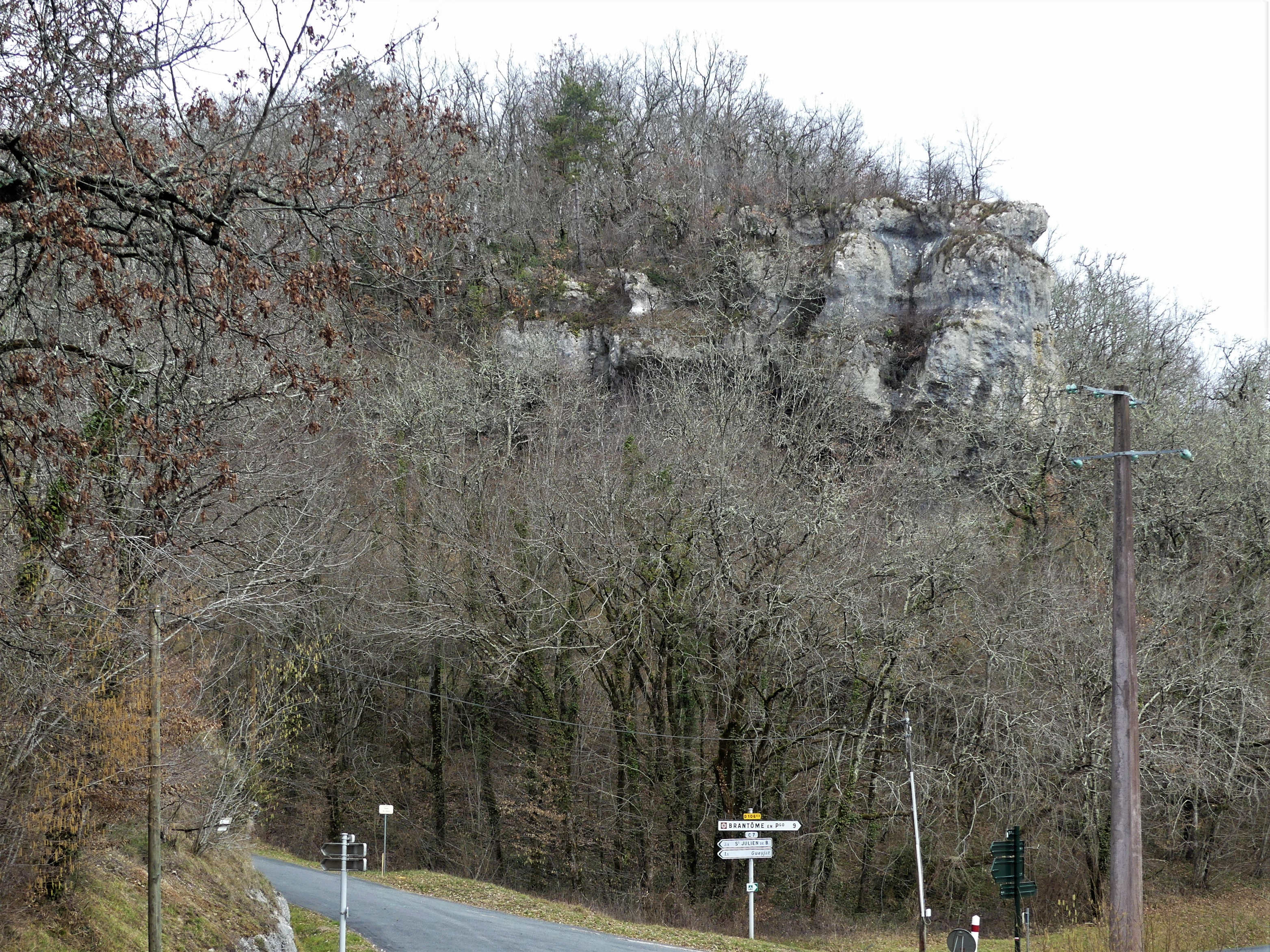
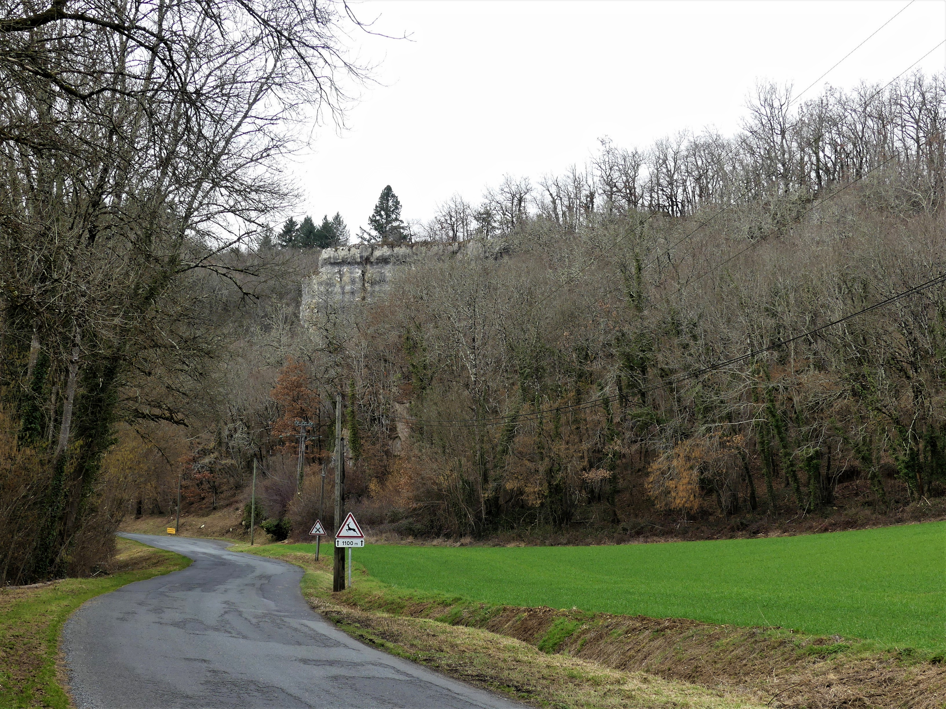
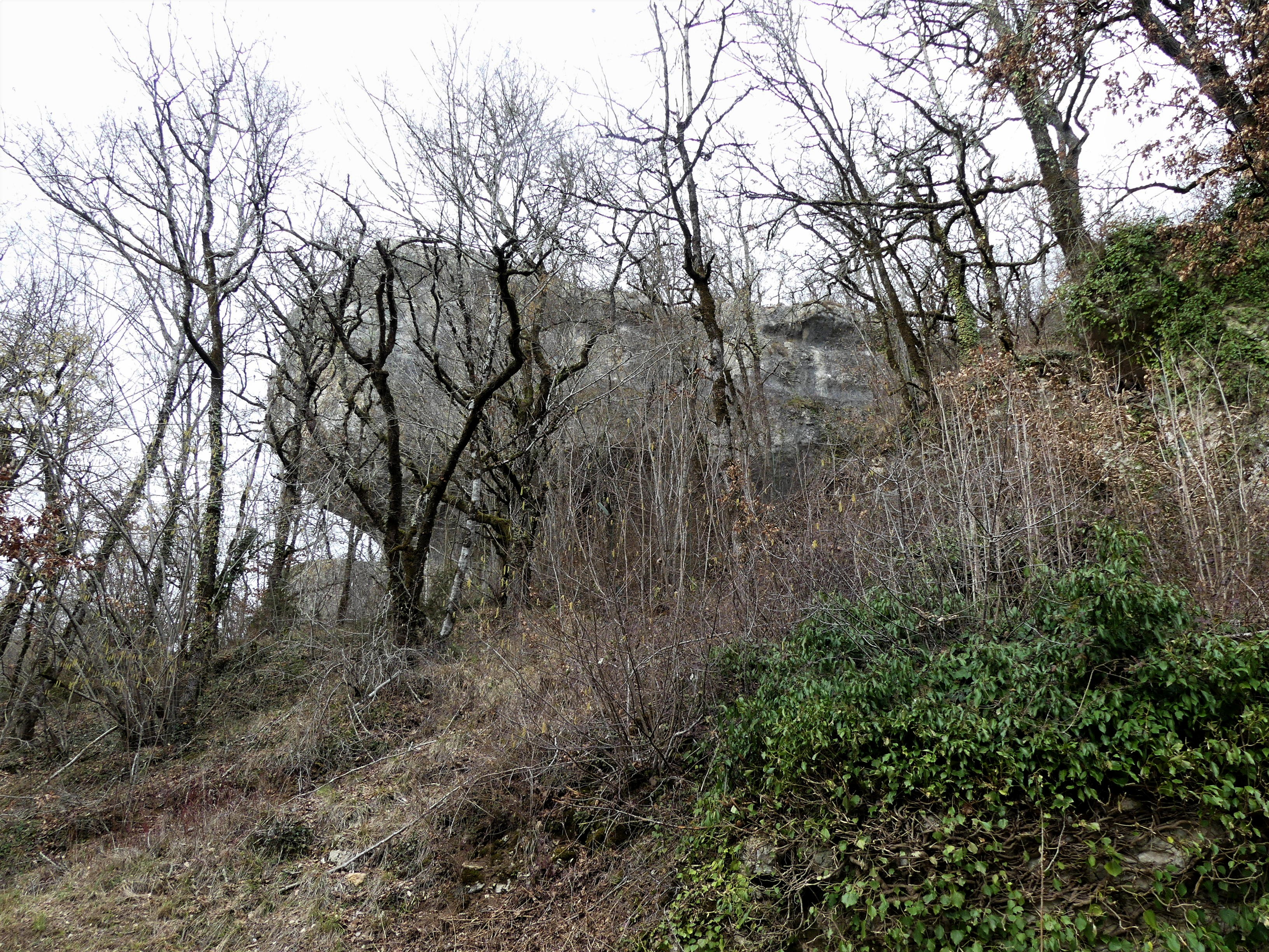
Grand Rocher
There are a large number of very skilled rock climbers in France, and they have a wealth of cliffs, often of limestone, on which to practice and hone their skills.The Grand Rocher is one of these, and is often mistaken for the Fourneau du Diable, which is only about three hundred metres away, where the road diverges, at the corner of the route des Rochers ( RD 106E2 ) and the route des Justes leading to the hamlet of Moneries. The Grand Rocher is the most difficult climbing rock in this area.
I am very grateful to Rudi Pohl, who pointed out to me that, along with many others, I had identified the Grand Rocher, falsely, as being Fourneau du Diable. There is even an official sign on the Grand Rocher cliff to that effect, which reads: Falaise de la Forge du Diable.
M. Pohl knows the area very well, and points out that the notches at the base of the grey limestone above had been cut by the river itself. The Dronne river once flowed circa 35 metres above the present level.
These notches are associated with gravel terraces that are found along the Dronne at other places. The highest notch here correlates with the Rissian ice age about 450 000 years ago, dated on an associated terrace.
All this implies that the country rocks have been slowly rising since then, and the river kept cutting down. M. Pohl has calculated an uplift of circa 0.076 - 0.088 mm/year, which is a reasonably common uplift rate for some deposits.
It is important to realise that the Coniacian limestone sediments are also heavily karstified, eroded by dissolution, in the course of infiltration of water including CO2 from the atmosphere and soil, producing ridges, towers, and other landforms characteristic of karst.
This process produces tunnels, small caves and hollows, as well as, often, sinkholes. It is interesting for this site that the karstic features follow certain directions, predetermined by the local stress field.
Text above adapted from M. Rudi Pohl (pers. comm)
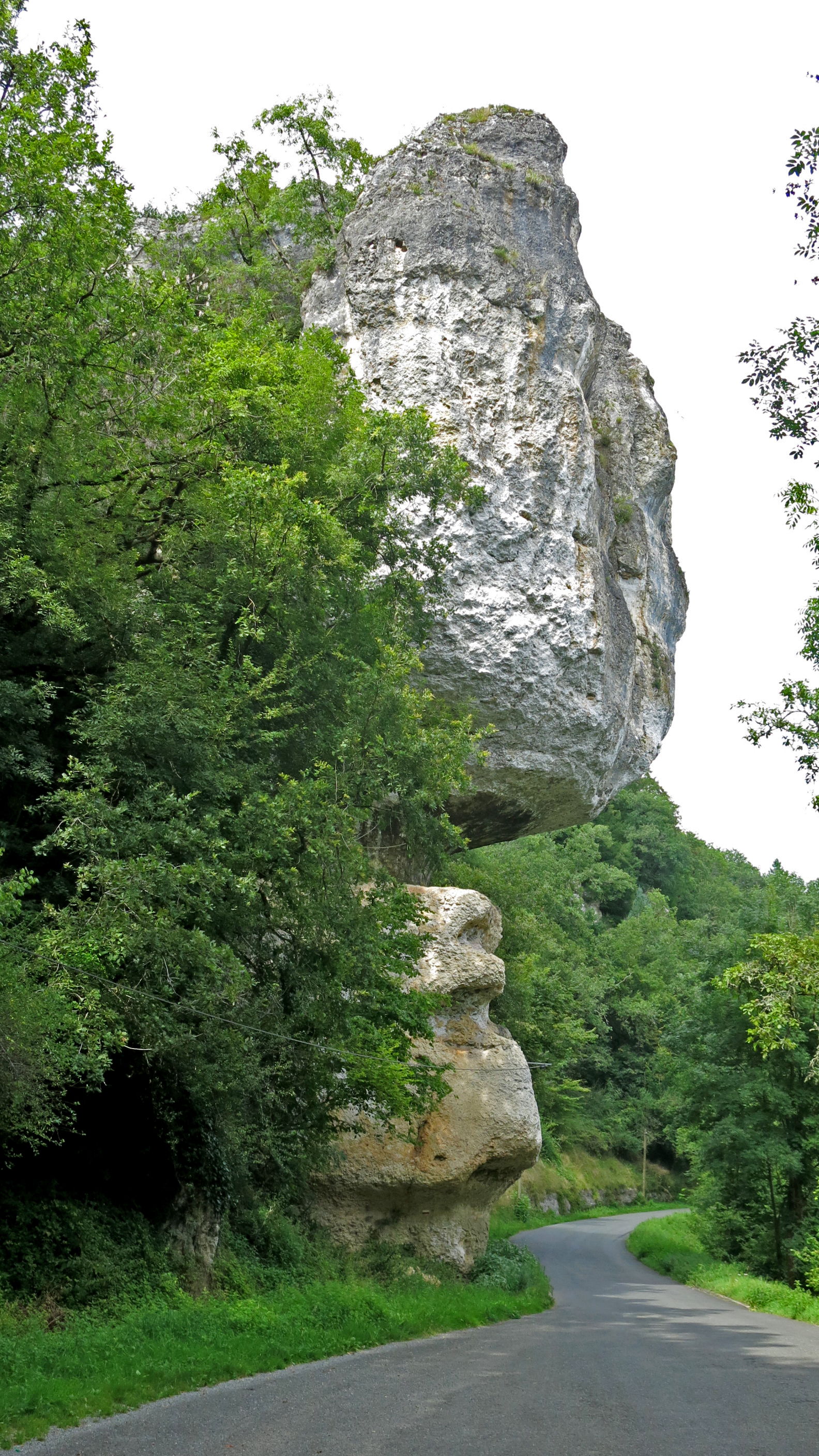
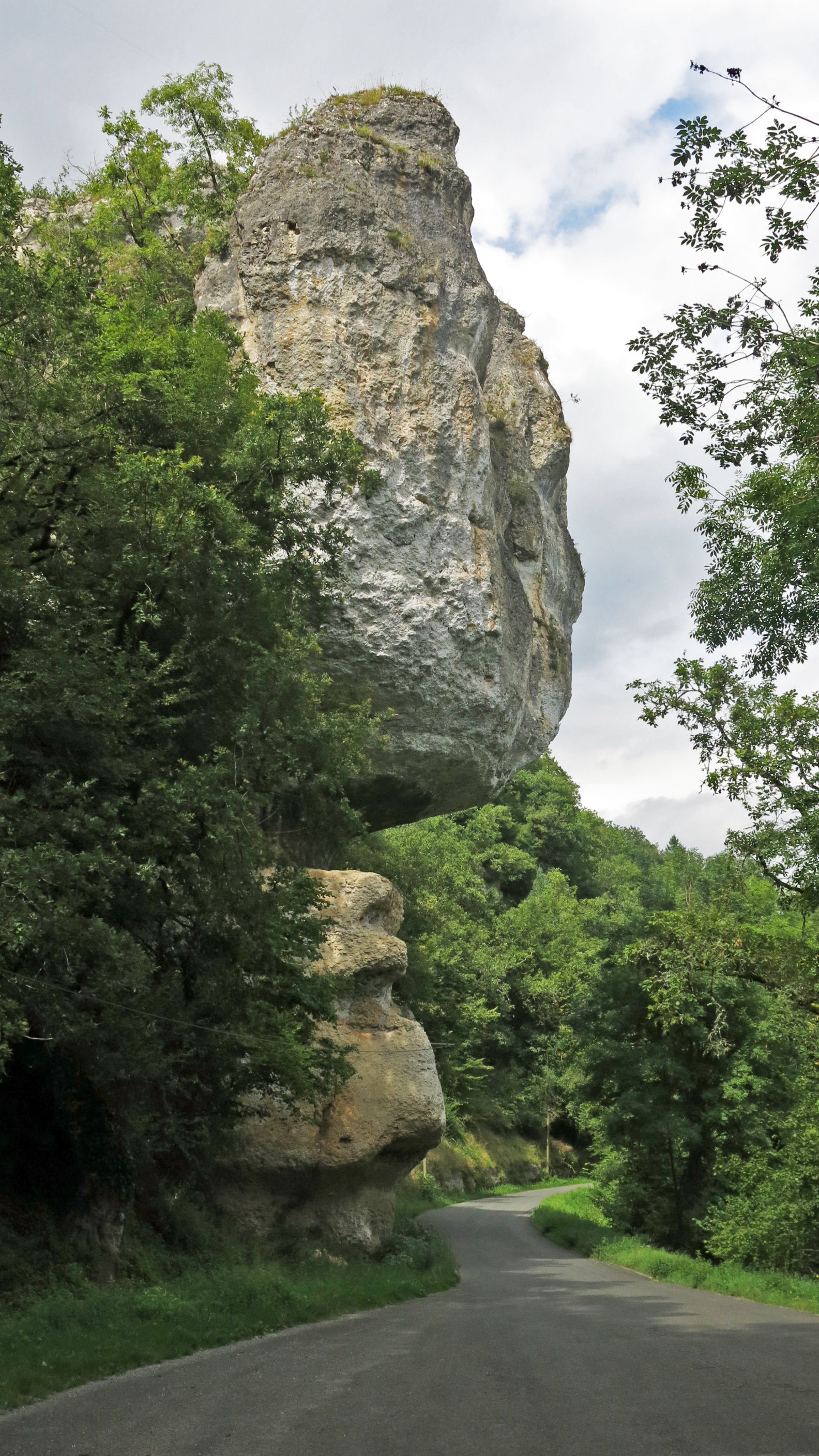
Grand Rocher, Bourdeilles, Dordogne
Photo: Don Hitchcock 2014

There are several abris in this complex.
It may be thought that horses could have been herded over the cliffs from the plateau above, a hunting technique requiring a great deal of skill and cooperation between the hunters.
However this hypothesis is not borne out by studies by Fontana (2001) of the age groups of horses slaughtered. Hunts were targeted on five to eight years old animals, and to a lesser extent on three to five years old horses. Running horses over the cliffs would have given a full age range for the horses butchered.
This section of Grand Rocher is well above the road, and is reached by a steep scramble up the hillside.
Photo: Don Hitchcock 2014
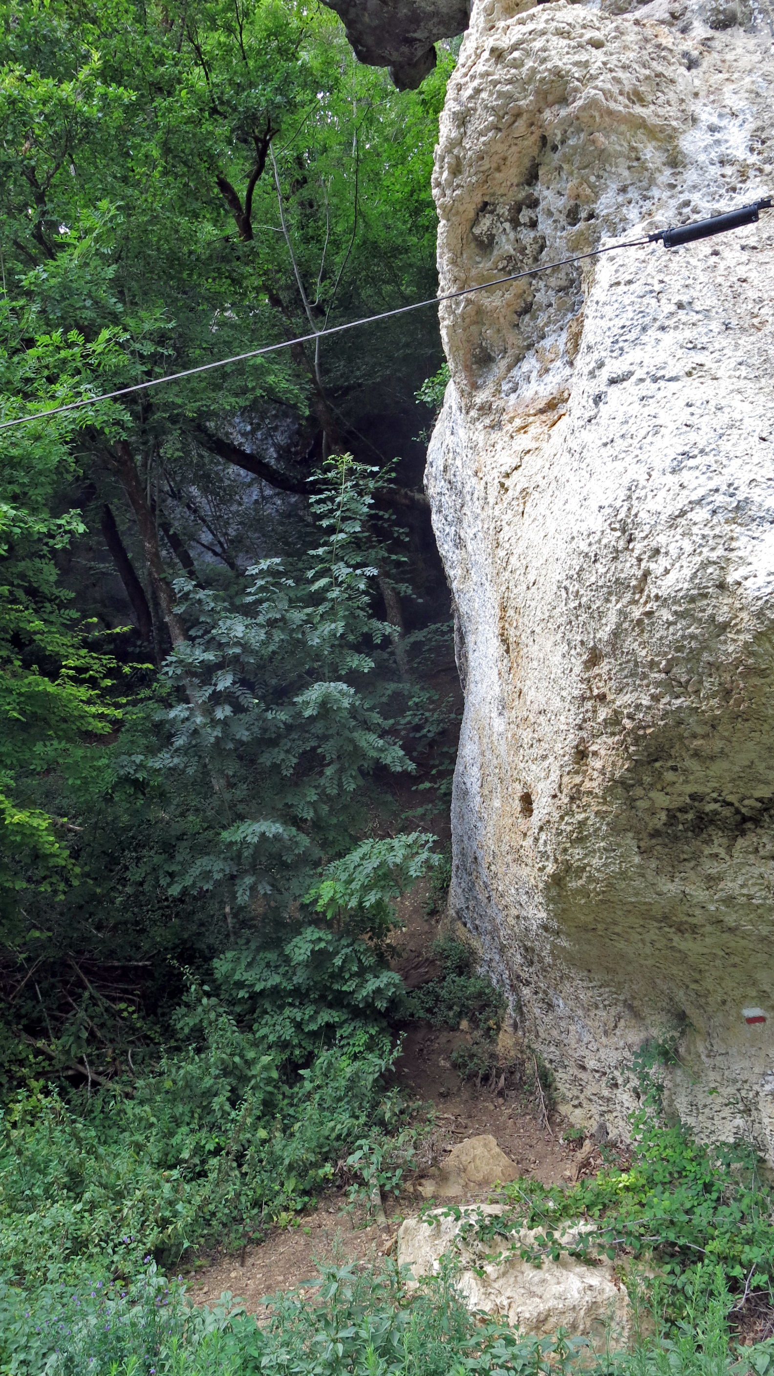
Many of the cliff walls are overhanging, providing shelter from rain and snow.
Photo: Don Hitchcock 2014
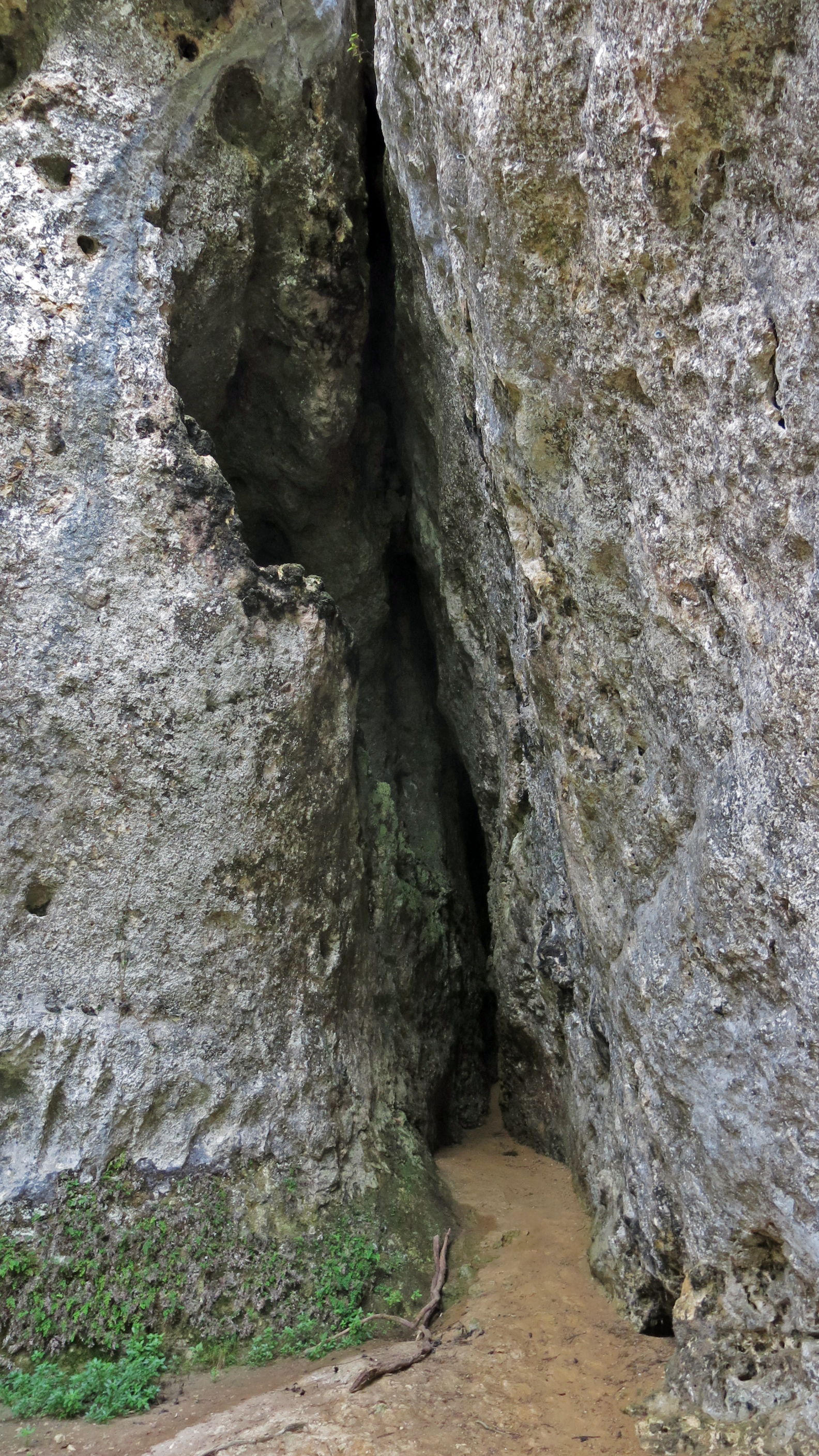
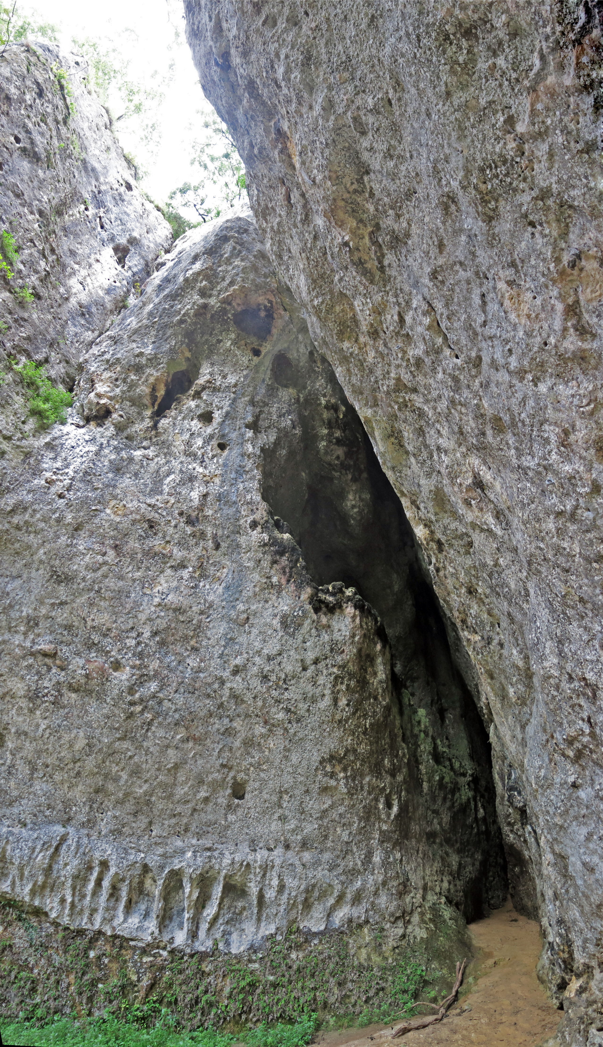
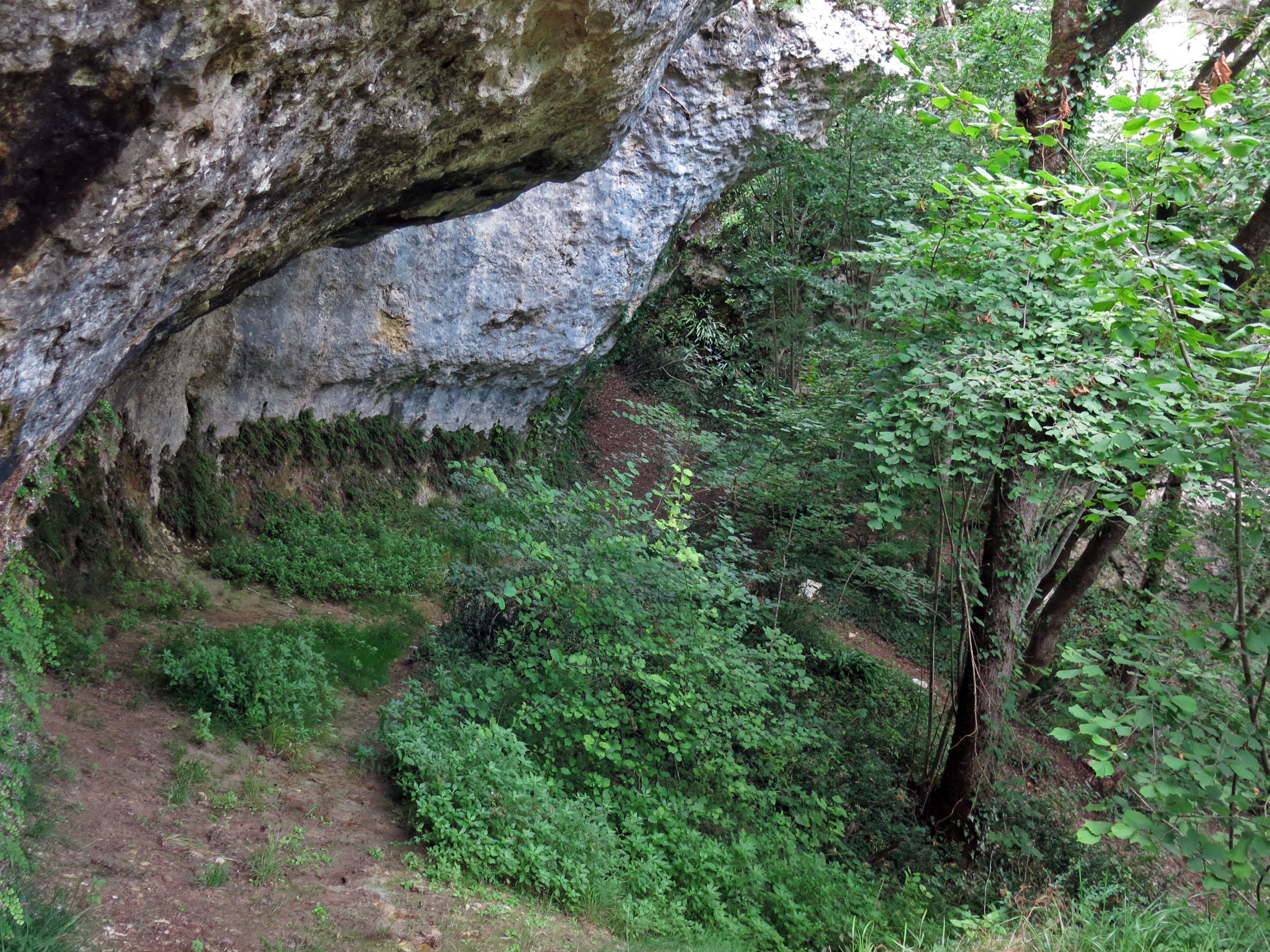
There are several deep clefts in the tall walls of the cliffs.
Photo: Don Hitchcock 2014
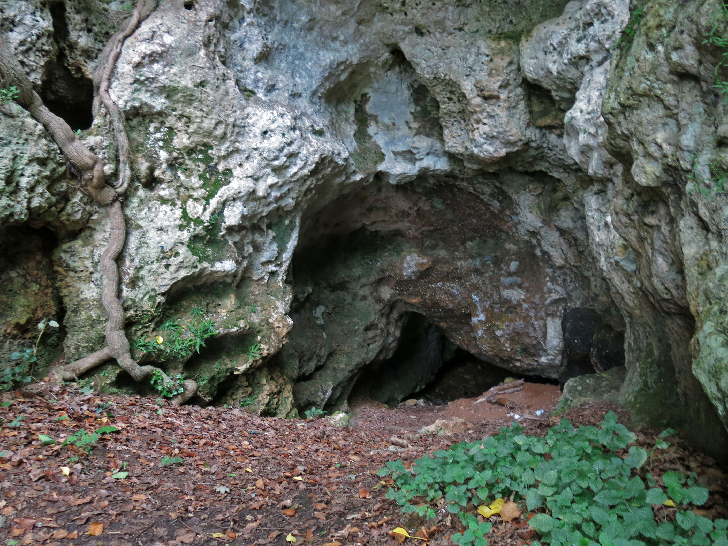
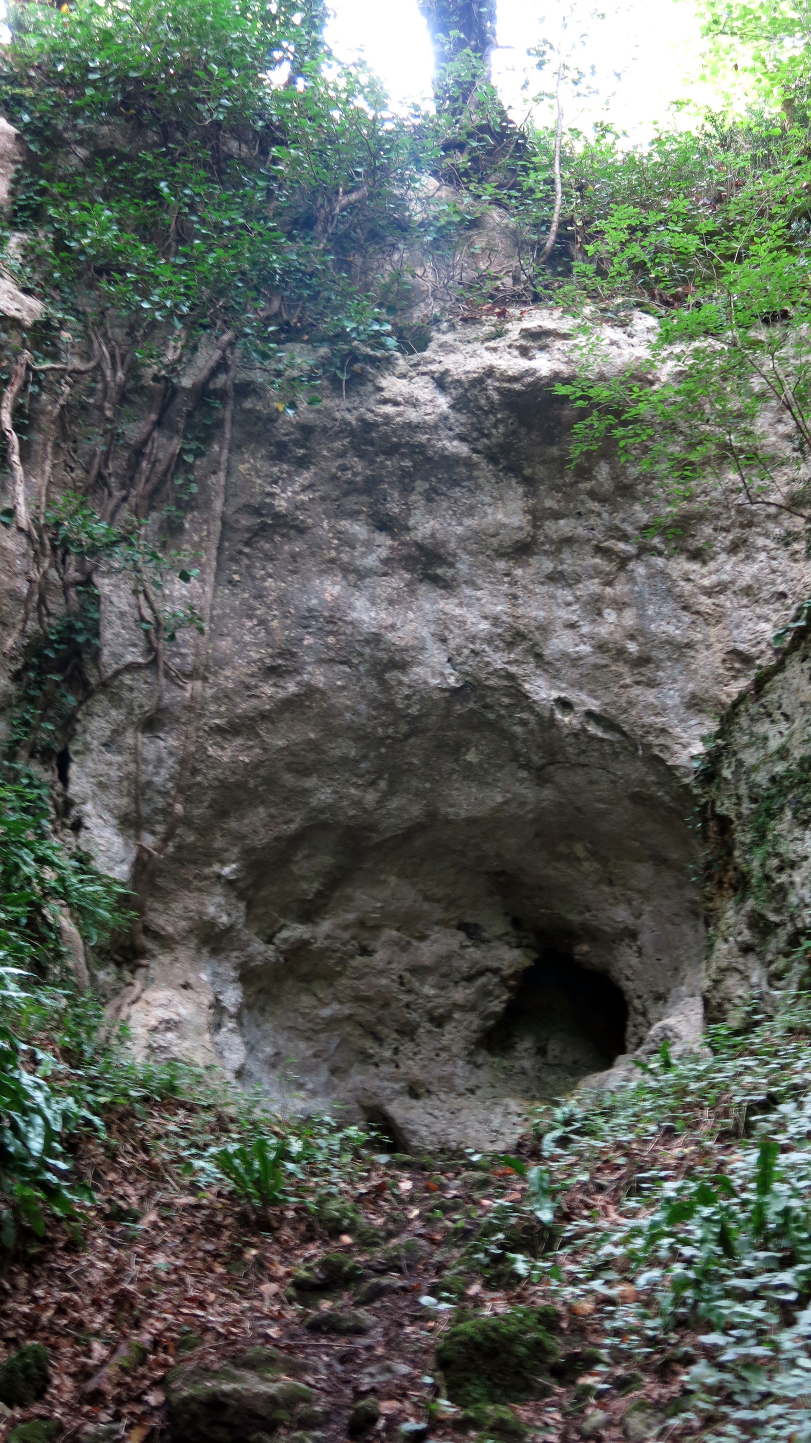
This small cave is well lit.
Photo: Don Hitchcock 2014
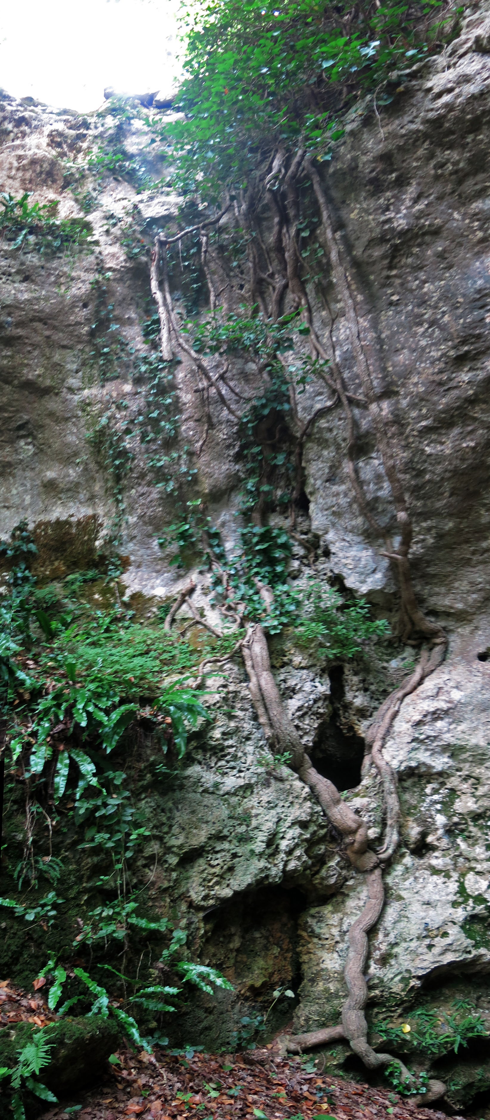
The cliff which overhangs the cave above has been used as a support by this plant which grows in the manner of fig trees, which let down aerial roots from the plant above, searching for moisture.
It is probable that this species of plant is only a recent coloniser of the site. Conditions would have been much colder at the time the abris near here were inhabited during the last ice age, and there would have been few trees except in the form of stunted gallery forests lining the rivers.
Photo: Don Hitchcock 2014
This cave has formed at the base of a limestone cliff which is not nearly as tall as the others in the area.
Caves can form for a number of reasons, including being part of a former underground river system, but these seem to have formed when water has percolated down through the limestone to reach a clay or marl layer, forming a spring at the base of the wall, which gradually dissolves the rock, forming a cave. Frost action on the back of the cliff where the rock is wet can then enlarge the cave and abri.
This type of cave often has the bonus of a spring of water right inside the cave, as at Laugerie Basse, where l'abri des Marseilles is blessed by an ever-running flow of cold, sweet water.
Photo: Don Hitchcock 2014
Some of the abris are shallow.
Note that Peyrony's drawings below show that areas such as these were extended by a fill of earth bordered by rocks placed at the edges, giving a much larger, flat terrace for the inhabitants to live on.
Note the moss, ferns and lush vegetation growing in a horizontal layer in this section of the cliff, where a clay or marl layer prevents water from percolating further down the rock, and moisture seeps out at the junction of the limestone and clay or marl.
Photo: Don Hitchcock 2014
This narrow gorge went a long way back into the limestone plateau beyond.
Photo: Don Hitchcock 2014

Looking back at the iconic cliff shape of Grand Rocher where the road passes it.
Photo: Don Hitchcock 2014
References
- Baumann M. et al., 2015: Le gisement préhistorique du Fourneau du Diable (Bourdeilles, Dordogne), UMR 5199 – PACEA, Rapport de fin d’opération annuelle, Site n°2405556 AP, Autorisation n°2015-32
- Capitan L., Peyrony D., 1921: Les origines de' l'art à l'Aurignacien moyen. La Ferrassie, Revue anthropologique, mars-avril, 1921.
- Capitan L., Peyrony D., 1925: Les reliefs Solutréens du Fourneau du Diable, commune de Bourdeilles (Dordogne), Comptes rendus des séances de l'Académie des Inscriptions et Belles-Lettres, 69ᵉ année, N. 1, 1925. pp. 43-52.
- Daniel R., 1969: Les burins de Noailles du Fourneau-du-Diable ; Commune de Bourdeilles (Dordogne), Bulletin de la Société préhistorique française. Comptes rendus des séances mensuelles, tome 66, n°1, 1969. pp. 16-18.
- Delluc B., Delluc G., 1982: Prehistoric Hunters, Hart Davis
- Duchadeau-Kervazo C., 1982: Recherches sur l’occupation paléolithique du Bassin de la Dronne, Thèse de Doctorat, Université de Bordeaux 1.
- Duhard J., 1989: Les figurations féminines sculptées de l'art rupestre paléolithique (Angles-sur-l'Anglin, La Magdeleine, Laussel), La sculpture rupestre en France, Colloque national sur la sculpture rupestre, Brantôme, 14 août 1989. Num. spéc. B.S.H.A.P, T.CXVI, p. 87-109.
- Fontana L., 2001: Étude archéozoologique des collections du Fourneau du diable (Bourdeilles, Dordogne) : un exemple du potentiel des faunes paléolithiques issues des fouilles anciennes, PALEO, 13 | 2001, mis en ligne le 26 mai 2010, consulté le 18 octobre 2015. URL : http://paleo.revues.org/1033
- Geneste J., Plisson H., 1989: Analyse technologique des pointes à cran solutréennes du Placard (Charente), du Fourneau du Diable, du Pech de la Boissiere et de Combe-Saunière (Dordogne), Paléo, n°1,1989. pp. 65-106.
- Peyrony D., 1932: The prehistoric sites of Bourdeilles (Dordogne), Archives of Human Paleontology Institute, 13 | 2001, n. 10, Paris, Masson, 98 p.
- Vignoles A. et al., 2019: Le Gravettien du Fourneau du Diable (Bourdeilles, Dordogne): révision chronoculturelle des ensembles lithiques de la 'Terrasse inférieure' Bulletin de la Société préhistorique française , Année 2019 116-3 pp. 455-478
Back to Don's Maps
Back to Archaeological Sites