Back to Don's Maps
 Back to Archaeological Sites
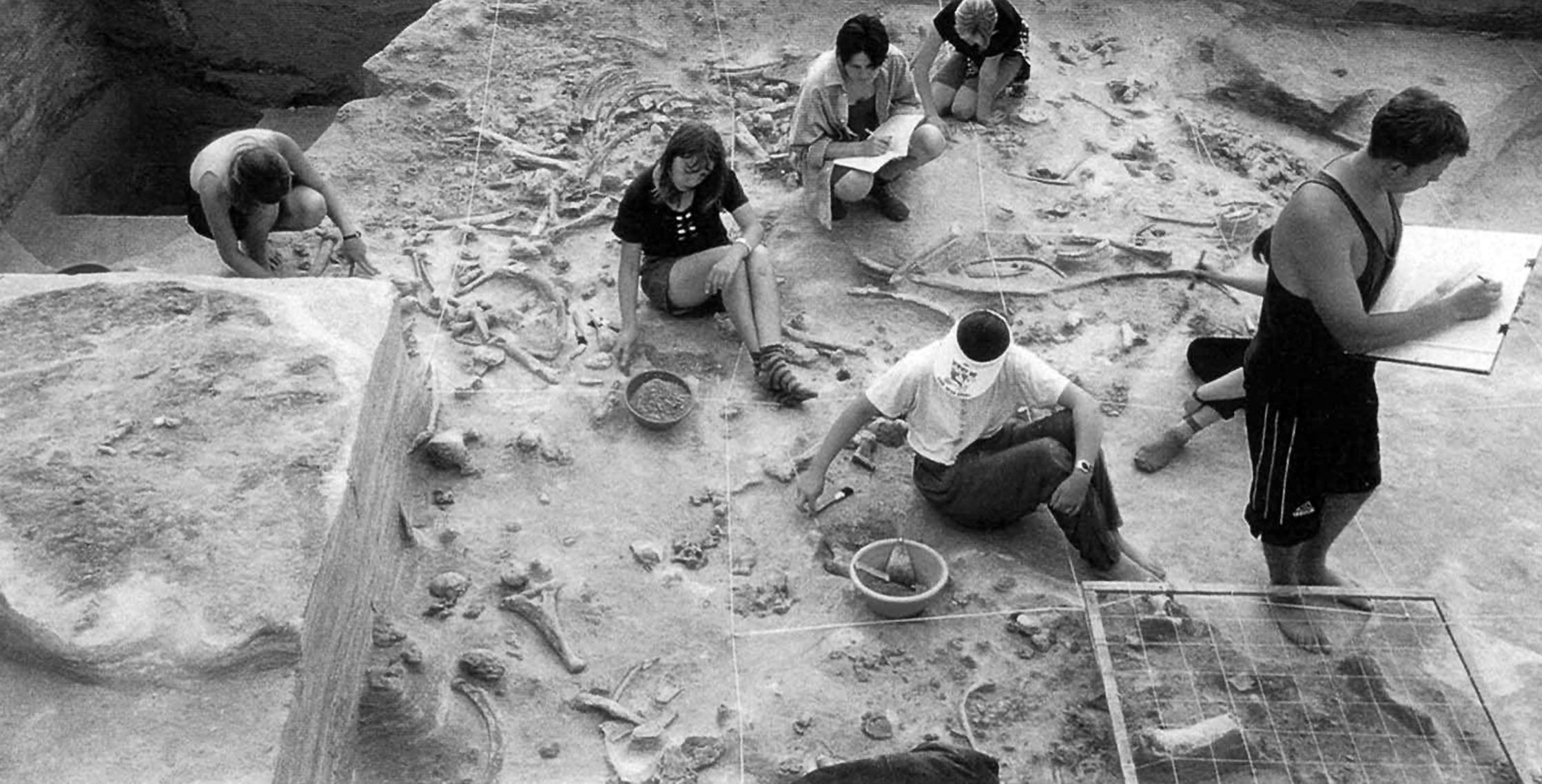
The Gontsy mammoth bone hut site

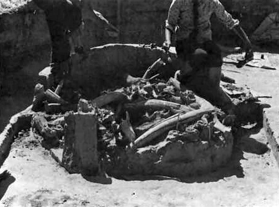
The mammoth bone dwellings № 3 and № 4 of the upper palaeolithic camp-site of Gontsy (Ukraine).
Photo and text: Iakovleva et al. (2014)
Gontsy was the first Upper Palaeolithic site to be found on the central Russian Plain, in 1871, and is the site of a series of mammoth bone huts. Gontsy is located on the right (southern) promontory formed by the second terrace of the Udaï River. The promontory faces north and is bordered today, as it was at the time of occupation, by ravines and the floodplain. It has been extremely well researched by Lyudmila Iakovleva and François Djindjian, who have not only described the site in a professional manner, they have done excellent work in teasing out exactly why and how the phenomenon of mammoth bone huts in the Dniepr plain occurred. Their paper entitled L'habitat à cabanes en os de mammouths de Gontsy (Ukraine), translated below, is a masterpiece.
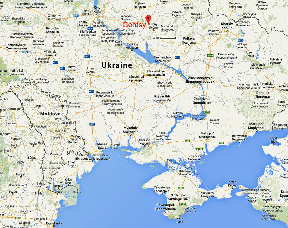
Gontsy / Ginsy / Hontsy / Hintsy / Гонцы (~ 50°10' N, 32°49' E; Lubenskii, Poltava) is located on the Udaï (Удай) River near the city of Lubny. It was one of the first Palaeolithic sites discovered in Eastern Europe (1871-1873), and has been investigated intermittently up to the present day. The occupation horizon rests primarily on colluvium on a low terrace 10 metres above the modern river level, and has produced seven radiocarbon dates that cluster between 14 600 and 13 200 years BP. Gontsy seems to have contained several former structures of mammoth bone with associated pits and hearths, along with an artefact inventory similar to that of Mezhirich.Text above: Hoffecker (2002), Soffer (1985)
Gontsy was the first Upper Palaeolithic site to be found on the East European Plain. It was discovered in 1871 when a landowner, in the process of some construction on his property, found mammoth bone and reported it to the local school teacher, Kaminskii. The site underwent sporadic and unsystematic excavations from 1873 to 1914. The first planned excavations were conducted in 1914-1915 by Schervakivskii and Gorodtsov. The site was subsequently investigated in 1935 by Levitskii (1947). The results of these excavations were published in a handful of articles - no monograph was ever done on this important Upper Palaeolithic site. Sergin began working again at the site in 1976, conducting small-scale salvage-type excavations in an attempt to recover new evidence from parts of the site excavated earlier.Text above: Soffer (1985)
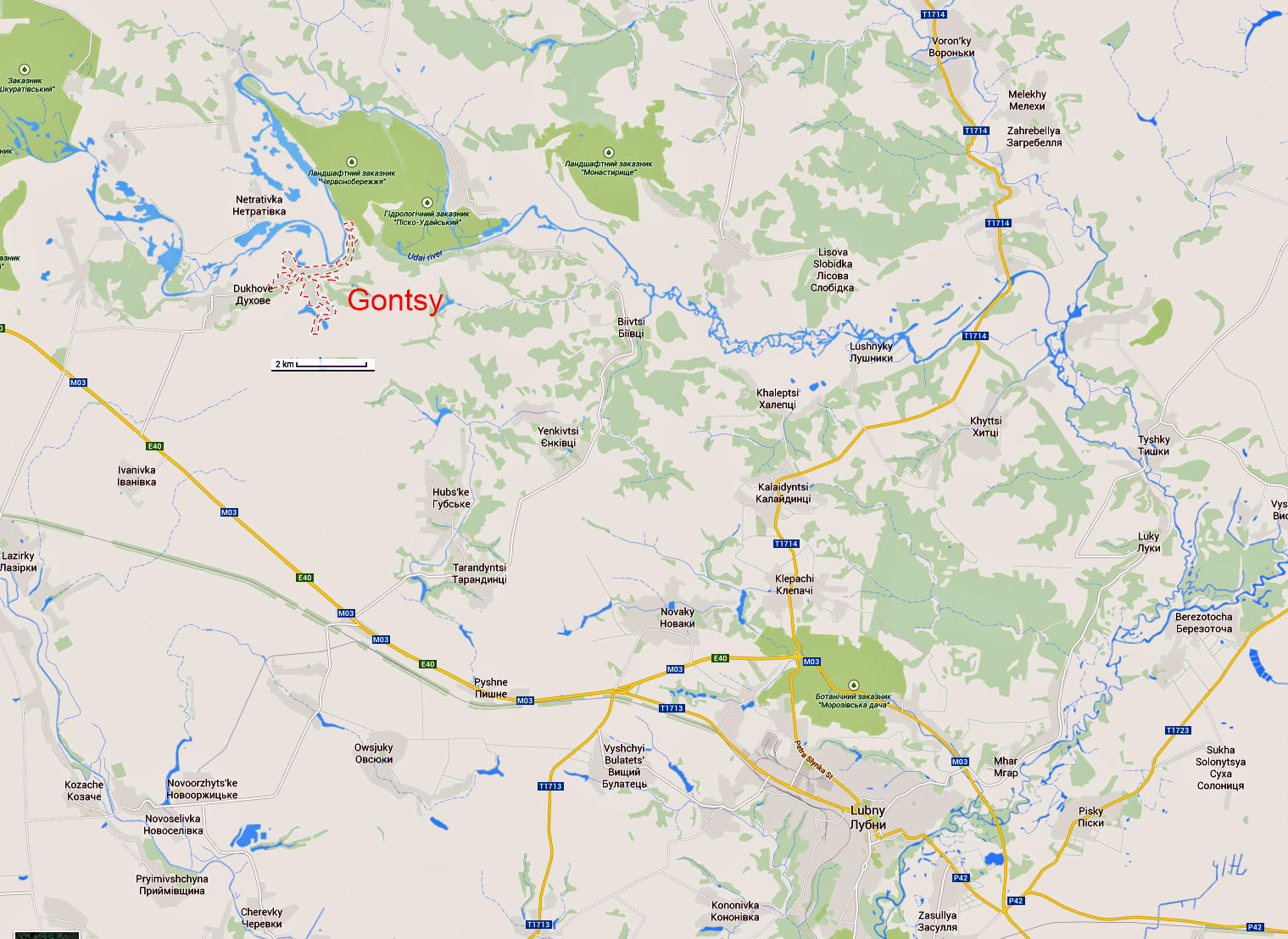
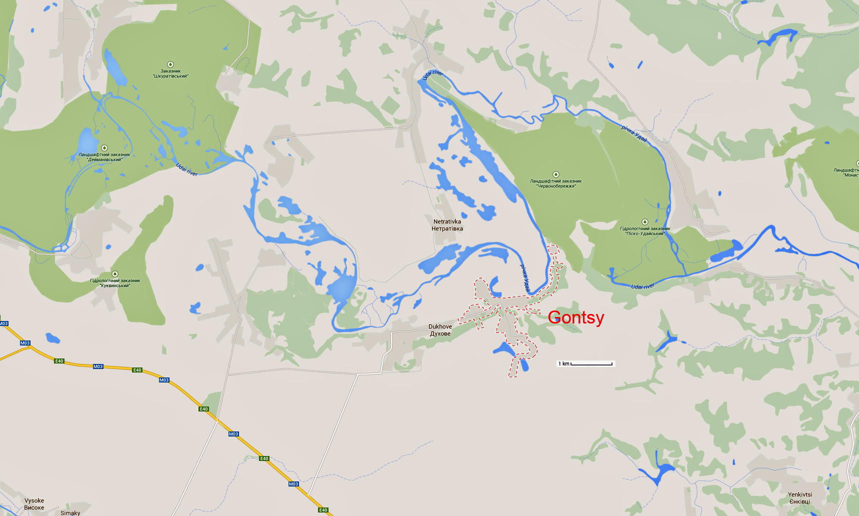
Gontsy is located on the right (southern) promontory formed by the second terrace of the Udai. The promontory faces north and is bordered today, as it was at the time of occupation, by ravines and the floodplain. Today the site lies 1.2 km from the river. The site's stratigraphy led both Gromov (1948) and Pidoplichko (1969) to conclude that people settled here on the floodplain itself and that the site was periodically flooded during the time that the Upper Palaeolithic groups inhabited it. By 1985, about 820 m2 had been excavated.
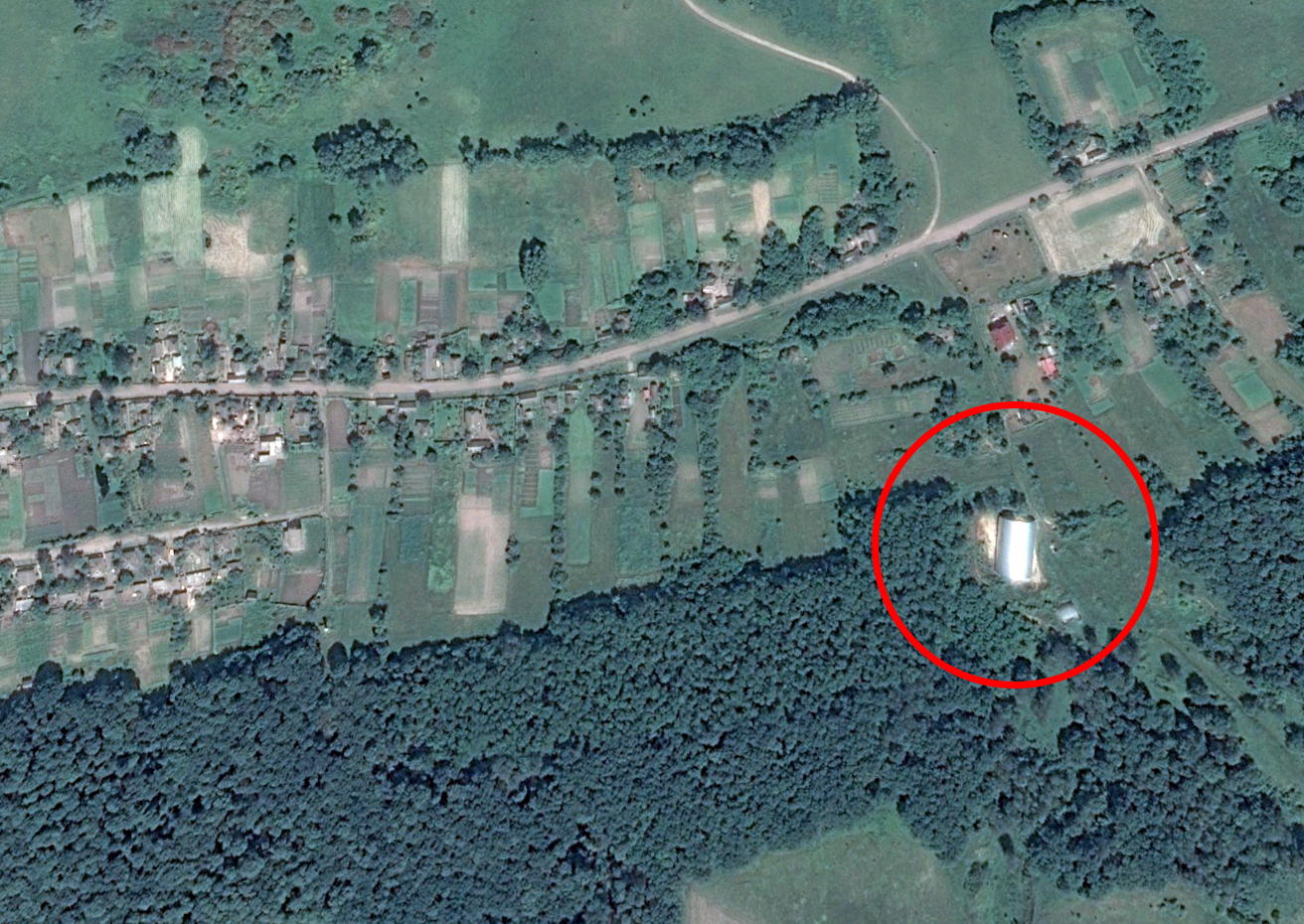
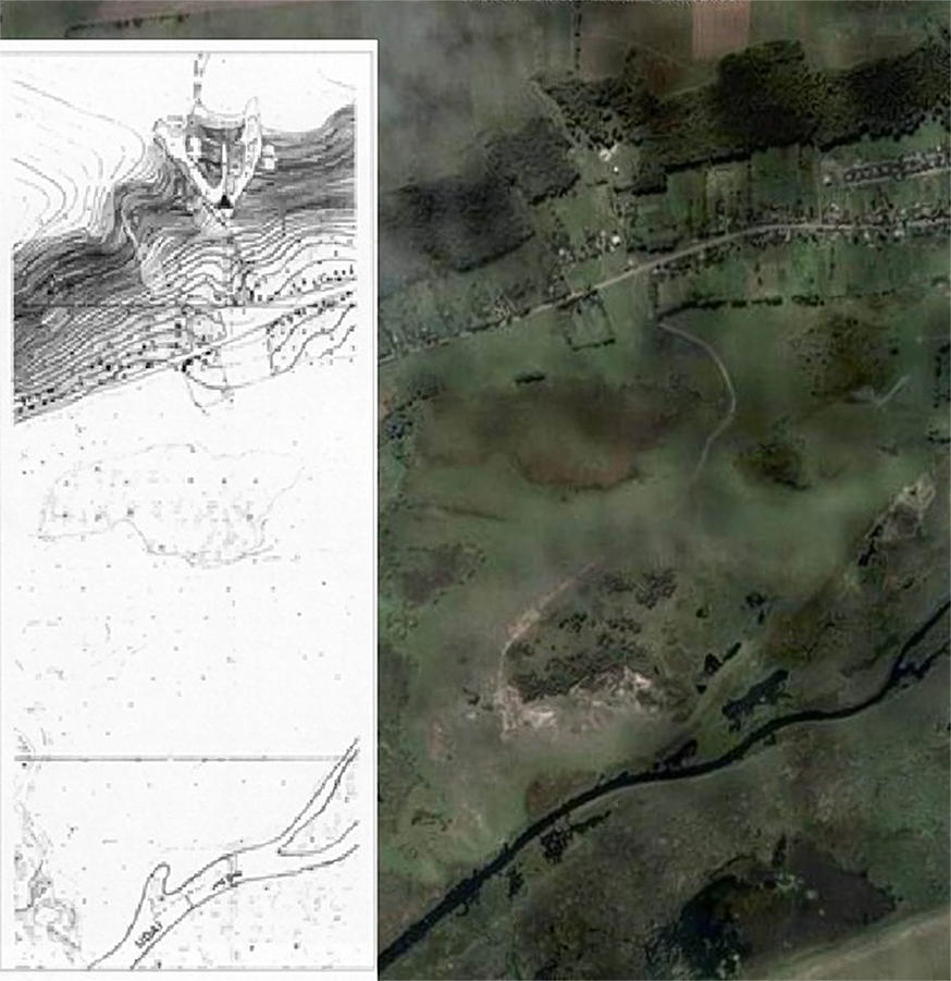
Location of Gontsy
Photo: Google Maps
Location of Gontsy
Photo: Google Maps
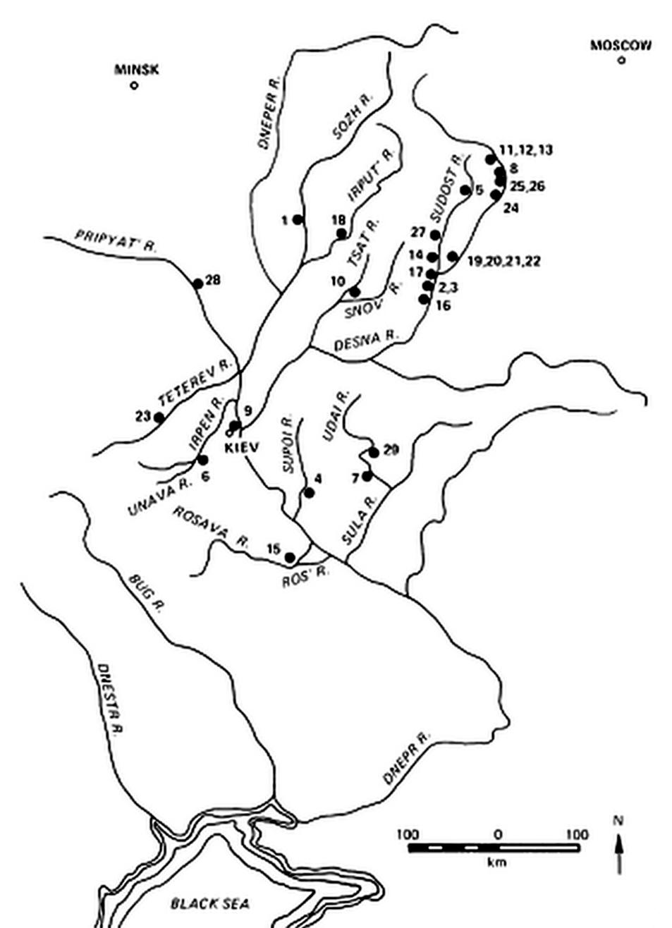
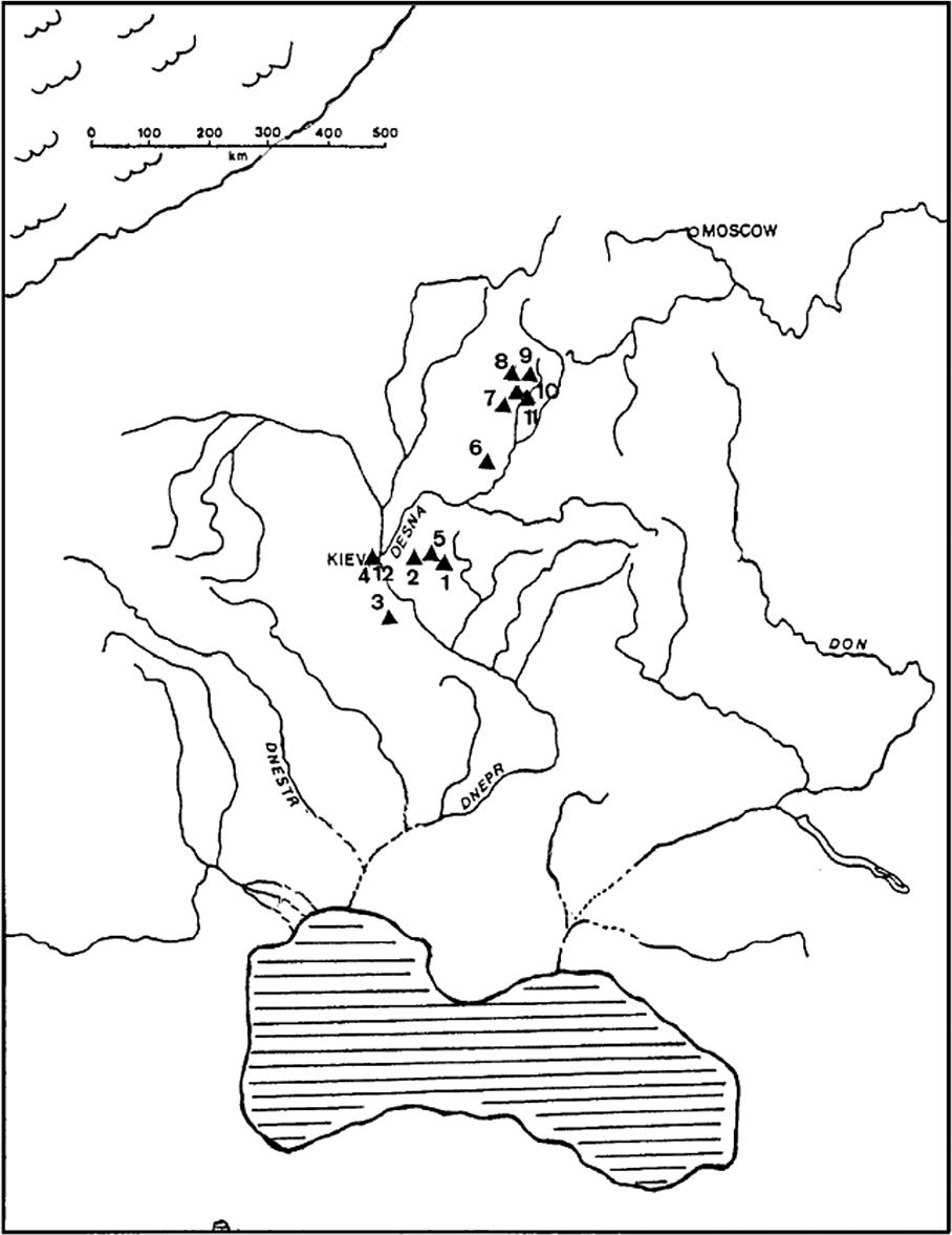
Upper Palaeolithic sites on the East European Plain.
1: Berdyzh, 2: Chulatovo I, 3: Chulatovo II, 4: Dobranichevka, 5: Eliseevichi
6: Fastov, 7: Gontsy, 8: Khotylevo II, 9: Kirillovskaya, 10: Klyusy
11: Korshevo I, 12: Korshevo II, 13: Kositsa, 14: Kurovo, 15: Mezhirich
16: Mizyn, 17: Novgorod-Severskii, 18: Novo-Bobovichi, 19: Bugorok, 20: Pogon
21: Pushkari I, 22: Pushkari II, 23: Radomyshl', 24: Suponevo, 25: Timonovka I
26: Timonovka II, 27: Yudinovo, 28: Yurovichi, 29: Zhuravka
Photo and text: Soffer (1985)
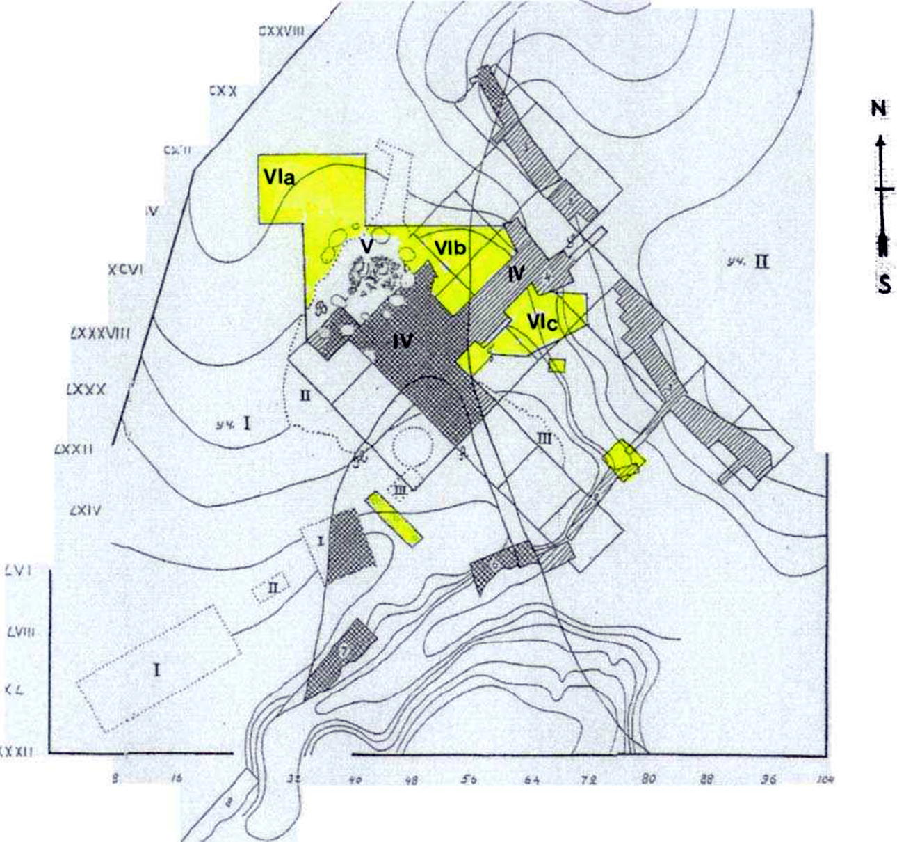
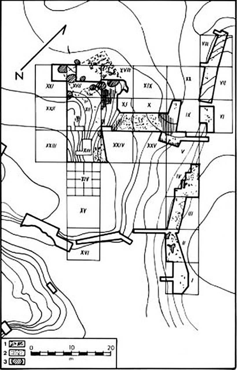
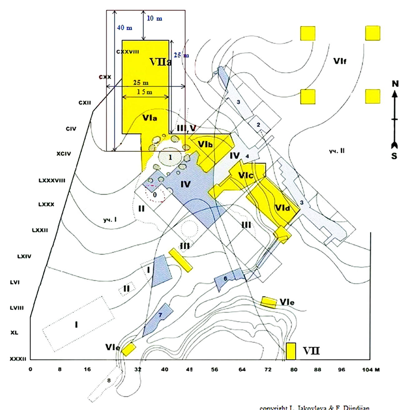
Map of the excavations of the Gontsy site between 1873 and 2012.
Zone I: Kaminski? (following Levitski)
Zone II: Guelvig? (following Levitski)
Zone III: Scherbakivski (1914–1916)
Zone IV: Levitski and Brusov (1935)
Zone V: Sergin (1977–1981)
Zone VI: Iakovleva and Djindjian (1993–2003)
VIa: Promontory: structures #1 to #4
VIb: Promontory: dump areas and butchering areas
VIc: Bone bed in the slope and the bottom of the eastern paleoravine.
Photo and text: Iakovleva et al. (2005), Iakovleva et al. (2012)

Temporary structures, Hangars 1 and 2, protecting the Gontsy site from the elements
Photo: © L. Iakovleva and F. Djindjian

Location of the Gontsy site, now protected by a large permanent structure.
Note that the sketch map has been rotated 180° from the published one so that it faces ~north, as does the Google Earth image.
Photo: Google Earth
Sketch Map: L. Iakovleva & F. Djindjian, Iakovleva et al. (2005)
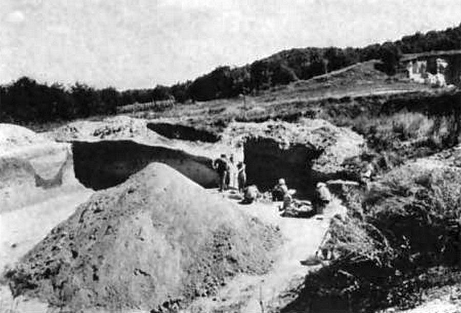
Gontsy excavations in the 1979 season.
Photo: Soffer (1985)
The excavations in Gontsy (1998) on the promontory (Zone VIa), towards the west: the structure № 2.
This is the small mammoth bone hut in the western part of the Gontsy site.
Excavations and photo: L. Iakovleva and F. Djindjian.
Text and source: Iakovleva et al. (2001), Iakovleva et al. (2005)
Past excavations in Gontsy.
1: bones
2: flint
3: storage pits
I - XXIII: excavations
Photo: Levitski (1947)
Text and source: Soffer (1985)

Gontsy worked bone, after Boriskovskii (1953)
Photo: Boriskovskii (1953)
Source: Soffer (1985)
Gontsy excavations, 1979.
Photo: Soffer (1985)
Gontsy storage pit 5, 1979.
Photo: Soffer (1985)
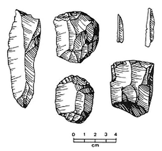
Gontsy lithics.
After Pidoplichko (1969)
Photo: Pidoplichko (1969)
Source and text: Soffer (1985)
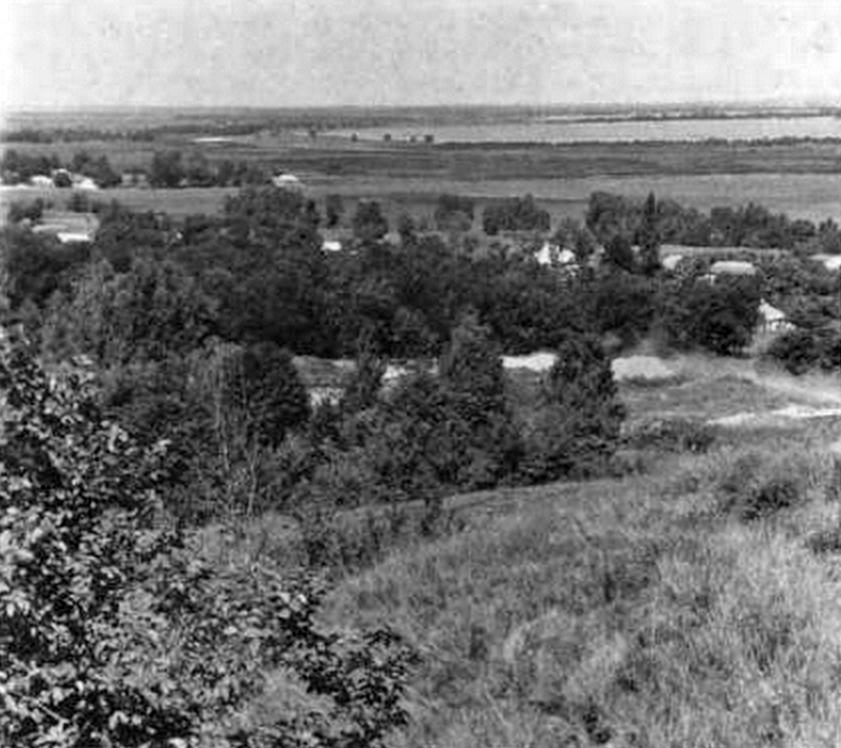
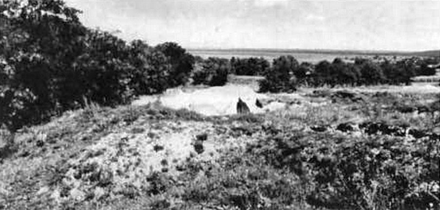
Environs of Gontsy viewed from the third terrace of the Udai River.
One 14C date for Gontsy is 13 400 ± 185 BP, obtained from burned bone in a storage pit.
Photo: Soffer (1985)
Fauna list for Gontsy: Arctic Fox, Boar, Brown Bear, Lynx, Wolverine, Bison, Hare, Wolf, Mammoth. Soffer (1985)
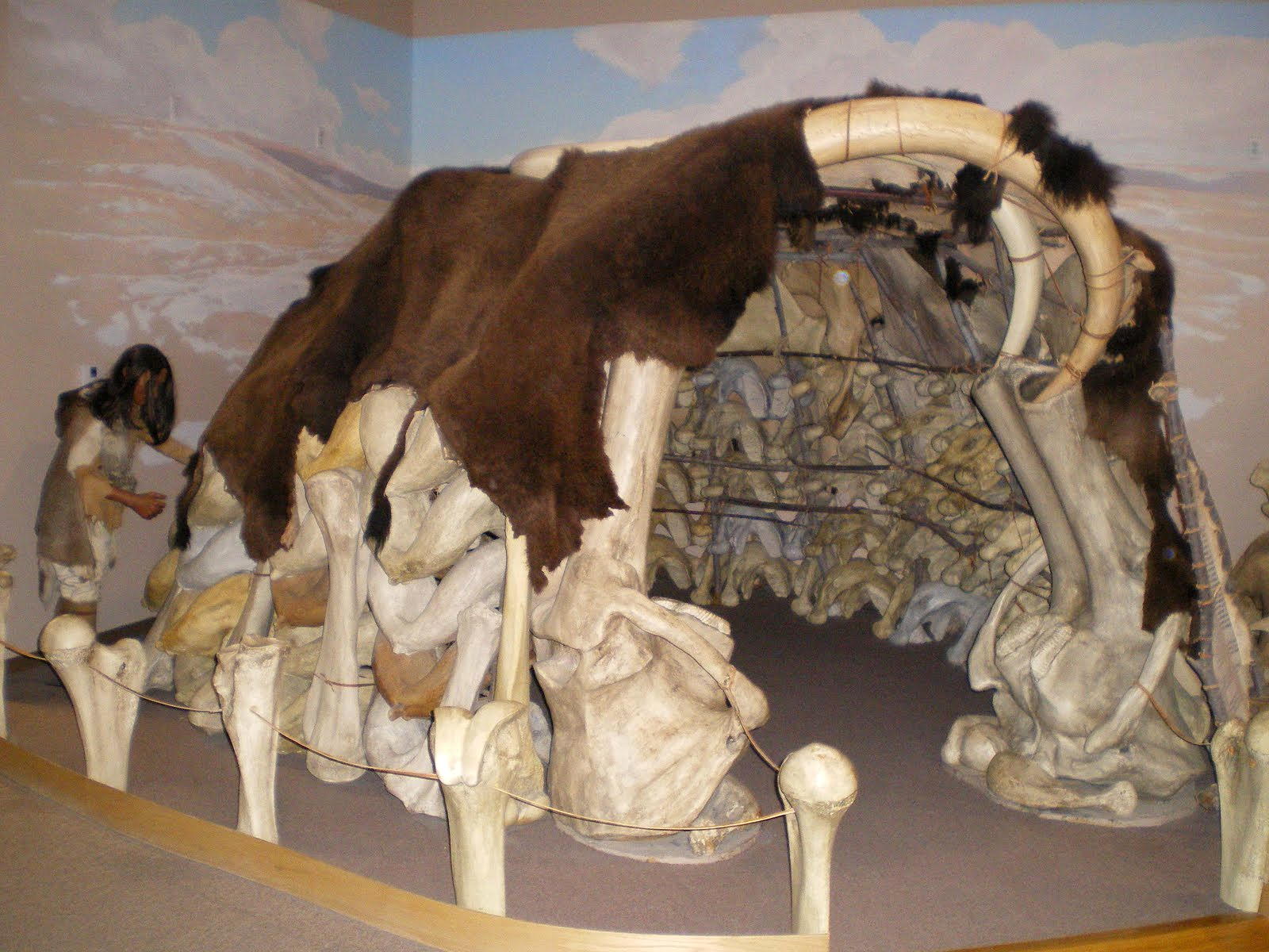
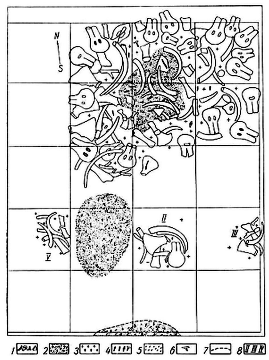 Gontsy mammoth bone dwelling reconstruction.
1 Mammoth bones
2 Ash lenses
3 Flint
4 Worked bone
5 Bone charcoal
6 Reindeer antler
7 Eroded ash lens
8 Storage pits
Excavation grid 2 x 2 m.
After Pidoplichko (1969)
Photo: Pidoplichko (1969)
Source and text: Soffer (1985)
Mammoth bone dwellings
Map of the mammoth bone dwelling settlements of the upper and middle Dnepr basin during late Upper Palaeolithic (Russia and Ukraine):
1: Gontsy
2: Dobranichivka
3: Mejiriche (Mezhirich)
4: Kyiv-Kirilovskaia
5: Semenivka
6: Mezine (Mizyn)
7: Ioudinovo
8: Elisseevichi
9: Timonovka
10: Suponevo
11: Chulatovo
12: Fastiv
Photo and text: Iakovleva et al. (2005)
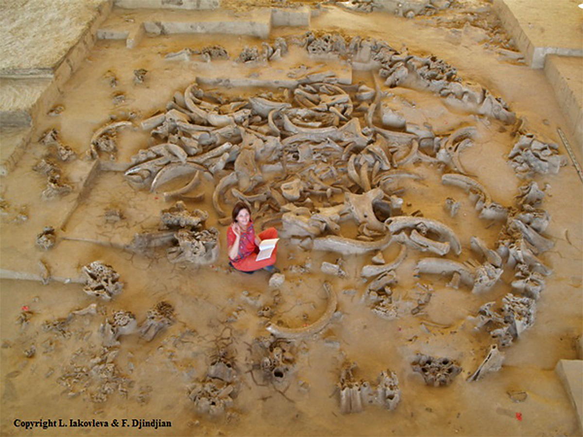
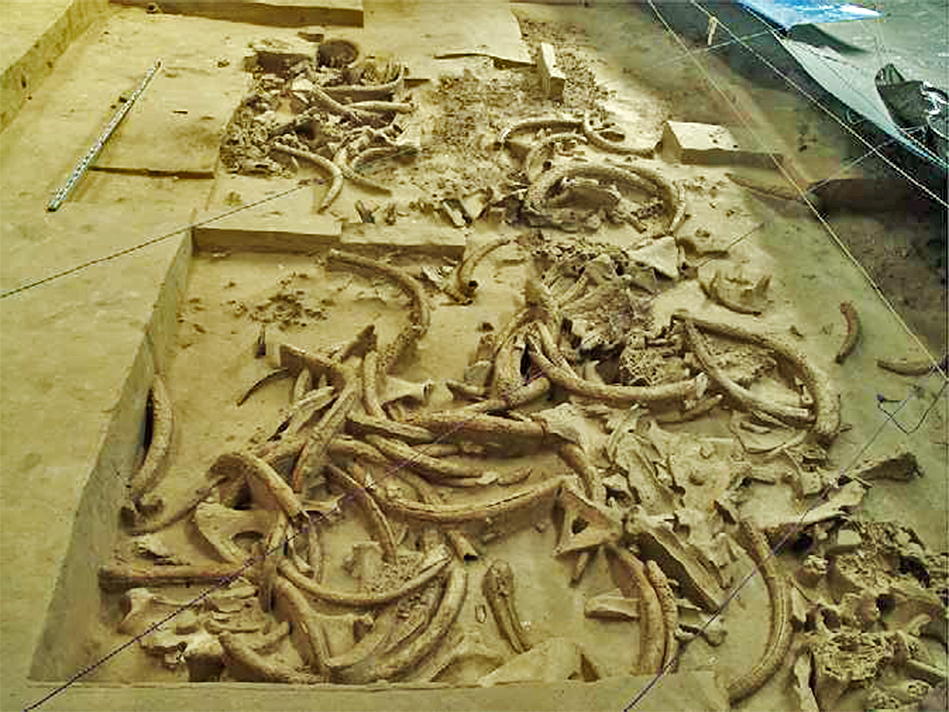
The 1993-2013 excavations at the Palaeolithic settlement of Gontsy allowed the discovery for the first time of the spatial organisation of a settlement of mammoth bone huts of the Upper Palaeolithic within their environment. It became obvious that the construction of the Gontsy settlement was directly linked to the existence of large mammoth bone beds intensively exploited by the hunter - gatherer groups, and which provided a particularly large quantity of mammoth bones for the construction of the huts, the manufacture of tools and weapons, and fuel for the hearths.

Photo: The mammoth bone dwellings № 3 and № 4 of the upper palaeolithic camp-site of Gontsy (Ukraine).
The mammoth bone huts are located on a promontory of the river slope, along a North-South line. There are four circular or oval large huts of variable dimensions (from 4 to 7.5 meters in diameter), made primarily by mammoth skulls, as well as a smaller hut.
Many pits surrounding the mammoth bone huts were used for the extraction of loess to plug holes and protect the walls of the huts from the cold, for storing food during summer on the permafrost layer of the bottom of the pit, for storing bone building materials and for dumping.
The architecture of the mammoth bone huts of Gontsy reveals that the largest bones of the skeletons of mammoths (skull, jaw, tusk, long bone, scapula and pelvis) are the main material for construction. Yet each hut in Gontsy has its own architectural features. Comparison of the huts of Gontsy with the huts of Mizyn, Dobranichevka, Mezhirich, Ioudinovo, and Kostenki 11 reveals individual features and common features that differentiate them, reflecting multiple functions: vital protection, social and spiritual life, cultural identification of the extended family, as well as the group and the intergroup relations within their geographical territory.
Photo: © L. Iakovleva and F. Djindjian
Source and text: Iakovleva et al. (2014)
The butchering area on the paleoravine slope in the eastern part of the Gontsy site.
Photo: L. Iakovleva & F. Djindjian
Source and text: Iakovleva et al. (2001)
The excavations in Gontsy (2002) on the promontory (Zone VIa), towards the north.
The mammoth bone structure № 3 partially excavated and artefact concentrations are apparent.
Excavations and photo L. Iakovleva and F. Djindjian
Source and text: Iakovleva et al. (2005)
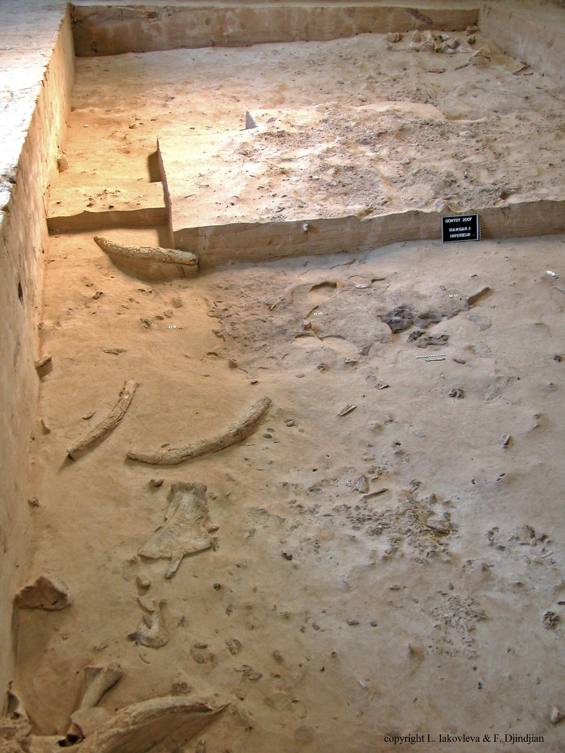
The working area above, showing the upper and lower layers (Gontsy, Hangar 1).
Photo: © L. Iakovleva and F. Djindjian
Source: Iakovleva et al. (2012)
Mammoth hut reconstruction.
Photo: http://kenergywind.com/uat2/photo-gallery/Network/mammoth-huts&page=6

The excavations in Gontsy (1997) on the promontory (Zone VIb), towards the east.
The stratigraphy shows the two occupation layers separated by thick loess layers and thin sand layers.
Excavations and photo L. Iakovleva and F. Djindjian.
Source and text: Iakovleva et al. (2005)
Photographs within the shelter which has been erected over the site.
Photo: © L. Iakovleva and F. Djindjian, 2013
Source: http://mae.hypotheses.org/1819
Photograph within the shelter which has been erected over the site.
Photo: © L. Iakovleva and F. Djindjian, 2013
Source: http://mae.hypotheses.org/1819

Photograph within Shelter 2 on the site.
The mammoth bone bed in the paleoravine (Gontsy, hangar 2).
Photo: © L. Iakovleva and F. Djindjian
Source: Iakovleva et al. (2012)
Mammoth bone hut № 2 (excavations in progress since 2009-2010).
Photo: © L. Iakovleva and F. Djindjian
Source: Iakovleva et al. (2012)
L'habitat à cabanes en os de mammouths de Gontsy (Ukraine)
une référence pour la reconstitution d'un système de chasseurs-cueilleurs dans son territoire basé sur l'économie du Mammouth
Translation: Don Hitchcock
Abstract:
The long-term excavations of the LUP (Late Upper Paleolithic) settlement of Gontsy (Ukraine), with its mammoth bone huts and associated mammoth bone bed, has allowed the reconstitution of nearly all of the pieces of the puzzle of this type of settlement, and the definition of the major role in the economy of the mammoth in the Mizynian peopling of the middle and upper Dnepr basin (Ukraine and Russia).
The settlements generally share the same geomorphology of the location on a promontory cut by ravines on the slope of a river valley. The dwelling area is organised around mammoth bone huts, numerous pits around each hut, large working areas with hearths, dumping areas, butchering areas for small and medium mammals, and the existence of a mammoth bone bed which has been largely exploited during the occupation of the settlement.
The landscape analysis, using information from mapping, functions, and seasonality of the settlements, has characterised a particular system based on the economy of the mammoth, limited to a short period between 15 000 and 14 000 BP, at the beginning of the climatic change ending the last ice age.
The network connections are supported by raw material procurement from a wide area, particularly flint and shells, but also amber, demonstrating the long distances travelled by the hunter-gatherer groups, both for the yearly search for the next settlement, and during the annual cycle for various seasonal procurements.
1. Introduction
The Gontsy site (Gintsy in Ukrainian) is located on the southern slope of the Udai River, a tributary of the Soula, in the middle basin of the Dnipro River, near the town of Lubny in the Poltava region of Ukraine. The discovery of the site in 1871 marked the beginning of Palaeolithic research in Eastern Europe.
Several mammoth bone dwelling sites have been excavated in the last one hundred and forty years by many archaeologists (Iakovleva 2010) in the middle and upper basin of the Dnipro (Figure 1) identifying a settlement territory of hunter gatherers specialising in the mammoth economy, for a short period from 15 000 to 14 000 BP (Djindjian et al. 1999: Iakovleva 1999, 2009a)

![]()
Map of Mizyn type sites between 15 000 and 14 000 BP in the Middle and Upper Dnipro and Desna Rivers, Ukraine and Russia.
1. Gontsy
2. Dobranichivka
3. Mejiriche
4. Kyiv-Kirilovskaia
5. Semenivka
6. Jouravka
7. Fastiv
8. Vilchanka
9. Mezine (Mizyn)
10. Chulatovo
11. Sevsk
12. Ioudinovo
13. Elisseevichi
14. Timonovka
15. Suponevo
16. Gorodok
17. Barmaki
18. Boujanka
19. Obolonia
Photo: © L. Iakovleva
Source: Iakovleva and Djindjian (2012)
2. The history of archaeological excavations on the site of Gontsy (1871-2012)
After the discovery of the site by GS Kyriakov in 1871, the first excavations were carried out in 1873 by F.I. Kaminski who published, with the geologist K.M. Feofilactov the first results at the Third Russian Archaeological Congress in Kyiv in 1878. (Kaminski 1878)
The site was then excavated in 1905 by an amateur, Guelvig, and then from 1914 to 1915 by V.M. Scherbakivski, curator of the museum of Poltava, who found the hut no1 (Scherbakivski 1919, 1926, Gorodtsov 1926 ), and then in 1935 by I.F. Levitsky and A.I. Brusov who searched mainly the accumulation of mammoth bones (Brusov 1940, (Levitsky 1947) and 1977-81 by V.I. Sergin who found and dismantled the hut № 1 protected and left in place by Scherbakivski. (Sergin 1981, 1983)
In 1993, a new research project led by L.A. Iakovleva (I.A. NASU) and F. Djindjian (Université de Paris 1 Panthéon Sorbonne) began a long-term program of excavations with the objective to reconstruct the whole camp in its environment. (Iakovleva and Djindjian, 2000, 2005, Iakovleva 2010, Iakovleva and Djindjian et al., 2012)
After twenty years of excavations, the site of Gontsy revealed several mammoth bone dwellings of various sizes, surrounded by numerous pits, multiple activity areas, discards and the remains of butchery around the huts and exterior fireplaces, and in the immediate proximity at the base of a paleoravine a vast accumulation of mammoth bones, the whole permitting for the first time a complete reconstitution of the encampment. (Figure 2)
3. Overview of the Gontsy site
The site of Gontsy is located on a slope of the valley of the Udaï, on the promontory of a terrace cut by the convergence of two paleoravines which descend to the plain (Figure 3).
The stratigraphy of the site was established from numerous coupes made on the promontory and in the paleoravines, permitting the reconstruction of a watershed geomorphology. The coupes reveal an occupation site with an upper and a lower level, demonstrating that the site was occupied twice in a short period, less than 500 years apart considering the overlap of the standard deviations of the 14C dates. The depth of the layer in the paleoravine was greater (75 cm of deposits caused by snow melt) where the rate of sedimentation was faster than in the habitat zone on the promontory (20 cm of loess).
In the lower level, the density of archaeological remains is very high and mammoth bone huts, pits, and zones of activity, rubbish disposal and butchery are directly and stratigraphically associated with the accumulation of mammoth bones along the slope of the promontory to the bottom of the paléoravine.
In the upper level, the density of archaeological remains is poor, the occupation was short, was centred amongst the collapsed huts, and was almost entirely covered with loess, as well as the area above the paleoravine which had by then been already filled in. The recovery and reuse of mammoth bones from the collapsed huts in some habitat locations was confirmed by microstratigraphic studies.
The site has been dated by the radiocarbon laboratory of Oxford by a series of thirteen dates between 14 110 and 14 620 BP, on samples selected from the upper and lower levels, in different areas of the inhabited area and in the zone of accumulation of mammoth bones. 14C dates on all the mammoth bone hut sites of the middle and upper basin of the Dnipro have recently been reviewed, and the duration of these settlements was reduced from the interval 22 000 -12 000 years BP to the interval 15 000 - 14 000 BP (Iakovleva 1999, Iakovleva and Djindjian 2005).
![]()
Plan of the history of excavations at Gonsky, Ukraine.
Photo: © L. Iakovleva and F. Djindjian
Source: Iakovleva and Djindjian (2012)
Spatial analysis of the lower level of occupation highlights several areas of specialised activities, categorised A to D:
A: the central area of the mammoth bone huts and their surrounding pits; separated by areas of activity organised around outdoor hearths.
B: areas of rubbish disposal, including the dumping of waste from hearths and from work activities.
C: butchery sites, limited to small and medium mammals hunted and brought whole onto the site (reindeer, carnivores, rodents).
D: the slope and the bottom of the paleoravine, the site of a large amount of mammoth bones, where some bones of other mammals are also found, mixed with the results of intensive human settlement, as demonstrated by the presence of numerous small hearths and flint tools scattered amongst the carcasses.
![]()
Geomorphology of the slope of the Udaï Valley and the location of the Gontsy site on a bluff cut by two gullies.
Source: Iakovleva and Djindjian (2012)
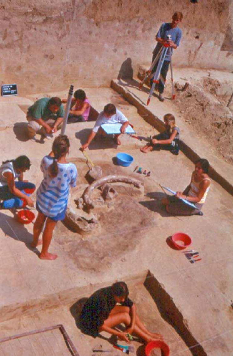
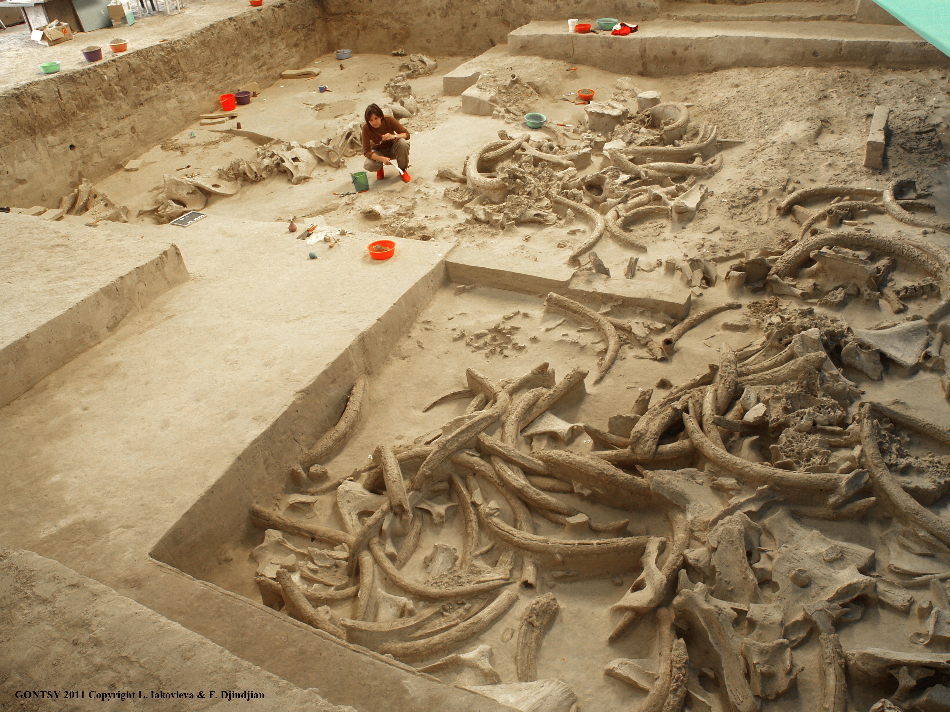
Since 2000, archaeological excavations have been conducted under large hangars which have allowed the excavation of the archaeological levels, without constraints of time or weather, and to keep in place the collapsed huts and archaeological deposits. Hangar № 2 was erected above the eastern paleoravine to allow the excavation of the the pile of mammoth bones over a surface of 100 m2.
Hangar № 1 was built on the promontory above an important, archaeologically rich area. The discovery of two new mammoth bone huts forced the construction in 2012 of a very large Quonset hut, 25m x 40 m (ie 1 000 m2 ) over the entire area covered by the previous sheds which will allow the excavation of the three mammoth bone huts in the years to come, and will conserve them in situ.
4. The Mammoth Bone Huts
The promontory on which the encampment was placed has an area of about 40 x 80 m2. In the present state of our knowledge, the huts appear to be roughly aligned in the north-south direction. The first structure (№ 0), located in the southernmost part of the dig, is believed to have been found by Guelvig in 1905. We know that three pits dug by Levitsky and Brusov in 1935 led to the hypothesis that there was a hut there.
![]()
Huts № 3, 4, and 5 in the process of excavation, preserved in the new Hangar 1a.
Photo: Gontsy 2011 © L. Iakovleva and F. Djindjian
Source: Iakovleva and Djindjian (2012)
The second structure (hut № 1) was found during the 1914-1915 excavations by Scherbakivski. It was built on the foundations of a circle of six metres in diameter using 28 mammoth skulls. Ten pits surrounded it (found by Scherbakivski, Levitsky and Brusov, Sergin and ourselves). The structure, protected by a wooden cover and re-buried in 1915 was inadvertently removed by Sergin in 1977.
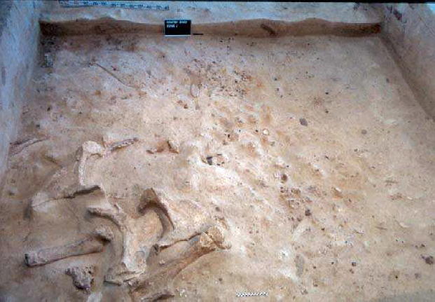
The third structure (small hut № 2) is a small hut of about 2.7 x 1.7 m2. It was built mainly from two tusks, a skull, a long bone and skull fragments. The hut is built on top of an oval depression filled by a black sediment resulting from either the decomposition of organic material from bedding, or the trapping of ashes from a fireplace placed on top of a filled pit located just south of, and near to, the hut. The interior of the hut gave up three exceptional pieces: a hammer made from the dropped antler of a large adult male reindeer, a pelvis fragment used as a dye container and the end of an engraved tusk from a young mammoth.
The fourth structure is a small cluster of mammoth bones, with an area of less than 3 m2, a minimum of three pelvises, a scapula, two tusks, two long bones and a skull fragment. The structure has not been excavated. It could be the top of a pit filled with mammoth bones.

![]()
Hut № 4 after excavation, preserved in the new Hangar 1a.
Photo: © L. Iakovleva and F. Djindjian
Source: Iakovleva and Djindjian (2012)
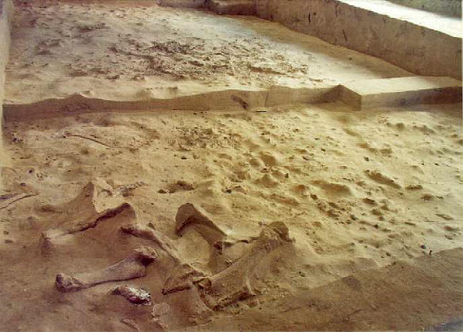
The fifth structure (large hut № 3 ) is a large hut over six metres in diameter, partially excavated in 2009 and 2010 over an area of 25 m2. This structure is largely under the west wall of the protection hangar and its further stripping is being postponed until after the construction of a new hangar.
The very preliminary inventory of 179 bones of the structure stands at 103 tusks, 50 scapulas, 8 skulls, 5 mandibles, 4 pelvises, and 9 long bones, for a hut of which we probably have only half the area uncovered at the time of writing (Figure 4).
The sixth structure (hut № 4), was completely uncovered in 2011, and was the subject of a comprehensive study in 2012 (Figure 5). It is a small hut with dimensions of 4 m x 2.6 m, and includes 62 large bones (15 skulls, 24 tusks, 14 scapulas, 6 pelvises, and 3 long bones). Foundations and walls are provided by an oval alignment of twelve skulls. Three remained in place, two have twisted outwards, six have twisted inward and one has rolled onto its side. Of the six pelvises, four were in the wall and two were discovered in the centre of the structure. Ten scapulas (plus four fragments) were placed in the wall. Twenty-two tusks were found with a remarkable distribution in the periphery of the hut, in the walls, and more numerous in the south wall than in the north wall. Three long bones were found: probably they were placed in the walls, one has twisted towards the exterior, and two towards the interior, of which the femur at the epiphysis has been engraved with a female symbol.
The collapsed structure had not been completely covered by sediment when the second site occupants arrived. Settling in the area to the northeast, they dug inside the hut as shown by the upper level dipping down steeply to that area in the hut and the displacement of some large bones.
This sixth structure was separated from the fifth at the end of the detailed study of 2012. These two structures are close to each other, and are separated by two square metres where there were found two long bones driven into the ground, which have been interpreted as the remains of stakes, a usage still at the moment hypothetical.
The seventh structure (large hut № 5), which was identified by a test pit of 2m x 2 m dug in 2006, is a large hut over six metres in diameter. Its uncovering began in 2011. In its southern part, 40% of the periphery consisted of a constructed wall of mandibles stacked in a V, with skulls and long bones aligned vertically.
In 2012, the stripping of the interior began. Of the 30 m2 uncovered of the hut in 2011 and 2012, the inventory of the 172 building bones is: 28 skulls, 7 skull fragments, 7 mandibles, 52 tusks, 43 scapulas, 4 pelvises, two femurs, 6 humerus, 1 fibula, 1 ulna, 3 tibia, 2 radius, 4 fragments of diaphysis / epiphysis, 6 ribs. These 30 m2 so far uncovered represent less than half of the hut as a whole (Figure 4).
5. Search Areas
The excavation of a mammoth bone huts site is not completed with the same technique as excavations of occupancy levels or for habitat structures from the Magdalenian. (Pincevent, Étiolles, Champréveyres, Monruz , etc.)
Excavation first meets the level of the collapse of the hut which consists of large bones detached from the hut at the time of its collapse, as well as numerous bone fragments such as pieces of skull, molars, and fragments of pelvises. This level of collapse is present only on the inside and in the immediate outer periphery of the collapsed huts. Excavation then reaches the wind blown loess clogging the walls that has been deposited inside and outside the hut, while the excavators leave in place the big fallen bones, to discover the living floor of the hut and hearths. Control benches allow a careful and controlled approach to the excavation. In no case will excavation continue as far as the base of the foundation of the hut walls.
The old excavations of the Mizynian mammoth bone huts were generally a process of dismantling to the floor of occupation, to reach the level of the foundations, located at the base of the circle of skulls, and into the deep pits, as at Mezhirich and Mizyn, allowing complete disassembly of the hut.
This approach left outside observers to feel that there was a void between the huts when in fact a thin layer of occupation is everywhere throughout the habitat. During the 1998 campaign, a search area, of 40 m2, located to the west of hut was stripped.
This uncovered, in addition to the small hut № 2 (structure 3), three pits which were full of mammoth bones, and topped with a hearth, a second small pit filled with scapulas, and a third small pit filled with debitage, a coloured hearth, a small heap of splinters, and a varied distribution of various relics that were the subject of a spatial analysis and functional analysis (the working of skin, bone, and wood).
Between 2001 and 2006, protected by the first shed, a search area of 66 m2 was excavated. It uncovered structure № 4 and several hearths. In this zone, an upper and a lower layer were present, separated by 20 cm of a sterile loess. This area is a direct extension to the north of the 1998 zone (Figure 6).
In 2011, excavation under the enlarged hangar 1a, was used to check the presence of this level of occupation between huts № 3, 4 and 5 over an area of 20 m2. An occupation level was found to be present throughout the site. And it was thus on all mammoth bone sites of this period.
![]()
Search area between huts № 1, 2, and 3 with the upper and lower levels investigated under the protection of hangar 1.
Photo: © L. Iakovleva and F. Djindjian
Source: Iakovleva and Djindjian (2012)
6. Waste and Discards Areas
To the east of hut № 1, beyond the pits, is aligned a series of clusters of garbage and waste, several metres long and two metres wide, oriented north-south. These include waste from hearths and discards from knapping (debitage). The waste from the hearths consists of ash and small fragments of burnt bone (white, gray and black in colour) and have the same composition as the hearths in the search area. The accumulation of debitage from flint knapping consists of breakages, splinters, small cortical flakes and fragments of small blades.
7. Butchery Area
Beyond the Waste and Discards Area is an area of about 10 m2 excavated during the 1997 campaign, consisting mainly of fragments of reindeer bones, carnivores and rodents, parts of which are still in anatomical connection (hare's foot). This area has been interpreted as a small butchery area and small and medium sized animals were brought whole to the camp.
8. Mammoth Bone Dump
The first mammoth bones appear while the promontory begins to drop into the paleoravine and they completely cover the slope and the bottom of the paleoravine for a hundred metres in a north-south orientation, following the gradient of the slope. At this level of the river, the ravine is only two to three metres deep and is already widely flared.
Only the western part of the gully was excavated between 1994 and 2006, the eastern part was excavated in 1935 by a long north-south trench. The reconstruction of the site of Gontsy is thus made possible in about 80% of our searches, supplemented by the publications of Kaminski, Scherbakivski, Levitsky and Brusov and the efforts of Sergin. Only the south-western part of the site destroyed by the excavation of Guelvig is unknown to us.
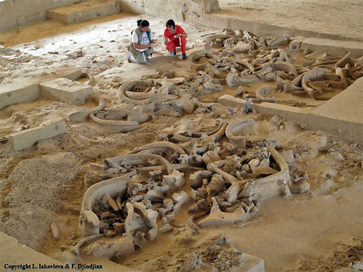
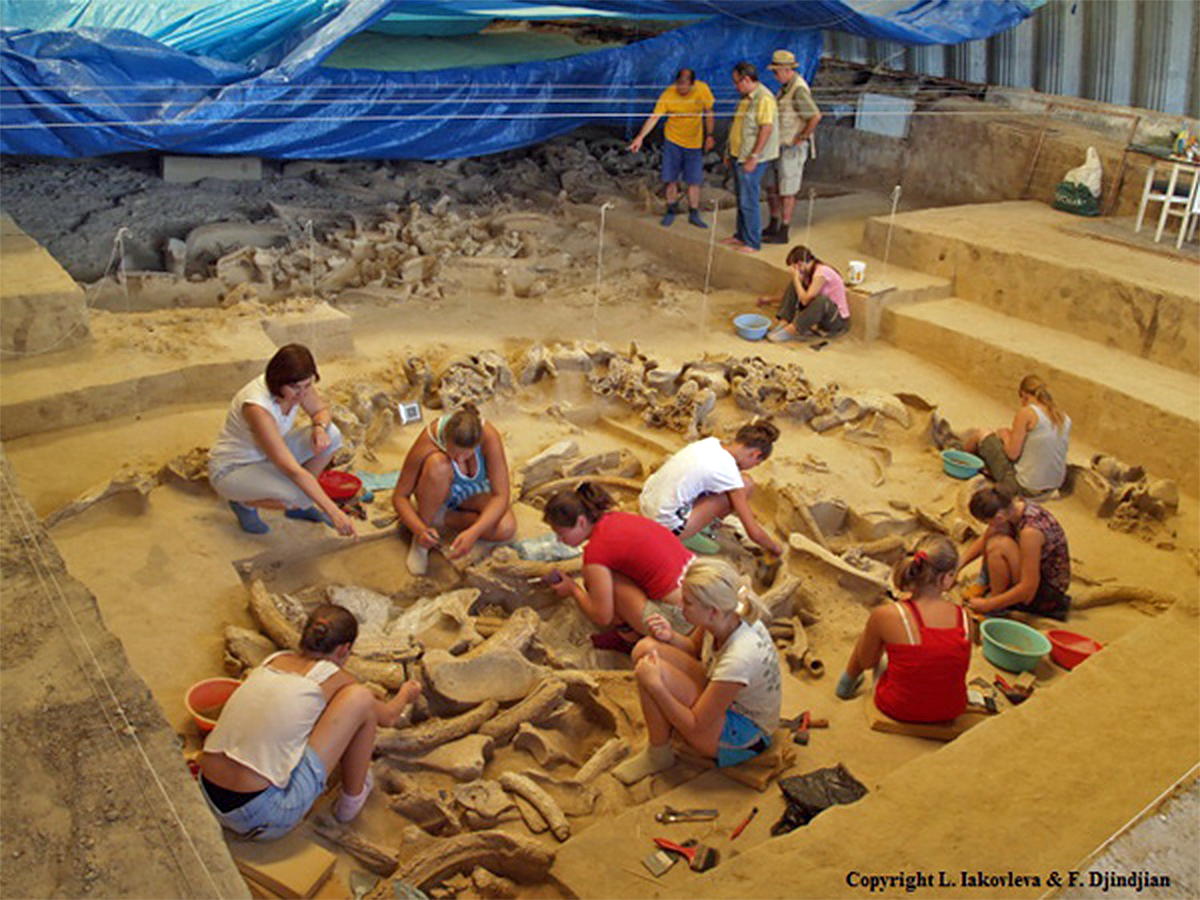
9. The Accumulation of Mammoth Bones in the Eastern Paleoravine
A large area of this zone was excavated during the excavations in 1935 of Levitsky and Brusov, and during our own excavations during the campaigns from 1994 to 2000 in the excavated areas, and conserved areas during 2004-2006 under hangar number 2, a total area of approximately 1000 m2 (Figure 7).
The detailed study of 80 m2 of deposits retained in shed 2 was recently published (Iakovleva 2010), and we quickly summarise here by integrating the results into the reconstituted whole 1000 m2 accumulation. The accumulation of mammoth bones is a unique layer, all based on the same silty sand lamination, which can be followed throughout the paleoravine.

![]()
Accumulation of mammoth bones conserved in Hangar 2.
Photo: © L. Iakovleva and F. Djindjian
Source: Iakovleva and Djindjian (2012)
The bones are in place except for the finest bone fragments finest that have been washed out by water from melting snow, and are found in one to two centimetres above the bones, and which the excavations reached first. There are no bones underneath or above the accumulation of mammoth bones, with one exception mentioned below, and there is no other accumulation of mammoth bones at any other depth in the paleoravine.
The paleoravine was filled very quickly (in less than 500 years) by silty sand layers at the bottom of the ravine, and silty clay layers at the top of the paléoravine, as a consequence of the decreasing gradient with the filling of the ravine.
75 cm of altitude separates the lower and the higher level in the paleoravine, demonstrating rapid sedimentation and revealing a climate change that time, if not in temperature but certainly moisture, causing heavy snowfall during the winter.
The bottom of the ravine was dry during winter as well as summer, refuting the hypothesis of a pond where mammoths might have come to drink or eat. The mammoth bones are intact, even if they are not found in the correct anatomical position due to the exploitation of the carcasses, although almost anatomical position examples are numerous, it is possible to identify the carcasses of which they are anatomical parts.
The mammoth bones are in perfect condition, without teeth marks from carnivores and without weathering, indicating rapid burial. The most fragile bones of the skeleton, such as fetal bones and hyoid bones are present and well preserved. The most numerous bones are the ribs, vertebrae, sternum and the ends of feet (phalanges metapodes, sesamoid, carpals, tarsus). They represent almost 90% of all bones (counting fragments).
So there is an overrepresentation of these bones and underrepresentation of shoulder blades, pelvises, skulls, tusks, jaws and long bones. This is exactly the opposite in the inventory of the bones used in the construction of huts. The attempt to reconstruct whole individuals from the bones failed, the bones of the skeleton still present are on average only 20% of a complete skeleton of bones, demonstrating significant anthropogenic exploitation of the accumulation of mammoth bones.
Mammoth bones were also used as fuel in many indoor and outdoor fireplaces in the camp, as indicated by the numerous bone charcoal fragments found in these hearths but also in the hearth garbage dumps, confirming that even fresh bones have been used in the fireplaces, and explaining the low percentage of anatomical parts per skeleton in the accumulation, which has been systematically exploited for the construction of huts, for fuel and for making tools.
In a previous publication (Iakovleva et al. (2010)), we highlighted the discovery there of the bones of a large adult male (with the presence of two tusks, a skull, a mandible, a scapula , half a pelvis and several long bones), which was an exception to the statistical distribution of anatomical parts mentioned above and the composition of a natural group of mammoth bones. Preventive restoration operations forced us to dismantle in 2011 many of these great bones to treat them in the laboratory, which has led us to discover below them individual subadult bones. The revision of the elevation data of all the accumulation of mammoth bones, allowed us to conclude that the adult male mammoth is not contemporary with the accumulation of mammoth bones, but later than it and later than the occupation of the camp. We have also been able to find in the excavated areas between 1993 and 2000, some bones of the adult male, they too located a few inches above the level of accumulation of mammoth bones. So the bones came from an old solitary male who happened to die there.
Of the 80 m2 accumulation conserved in hangar 2, the group of mammoths is now composed of six different age and gender individuals, including one adult female, two indeterminate adults, a sub-adult and two juveniles. They therefore correspond to a natural grouping. A few isolated bones of other mammals are present in the midst of mammoth bones. They come from the lower level of habitat occupancy of the promontory and were thrown to the bottom of the paleoravine, further confirmation of contemporaneity between the accumulation of bones of mammoths and the lower level of the habitat. In 2011, two bones of the same foot of a reindeer have been found, one from the accumulation of mammoth bones in the ravine and the other from lower layer of the habitat under the hangar 1a.
Many hearths have been found in the accumulation of mammoth bones (ten hearths in the 80 m2 of hangar 2) showing the significant need for fire for the exploitation of the accumulation of mammoth bones, which can only be explained if the carcasses were reduced to bones: thawing of the flesh, burning of the skin and hair, drying or smoking of meat, etc.
Tools were found among the bones of accumulation: blades and bladelets, burins, and fragments of cores generally having a cutting edge (about 115 artefacts). The use-wear analysis conducted by G. Sapozhnikova concluded that these artefacts were used as knives to cut meat for butchering activities. Tools of bone and ivory are also present, such as the extreme point of a young mammoth tusk and a retouched half pelvis used as a tranchet axe to split a skull. About a hundred little fragments of molars were also found amongst them.
In conclusion, the study of the accumulation of mammoth bones at Gontsy highlights the existence of a natural group of mammoths, intensely exploited by man, for the supply of building materials for their huts, fuel for its homes, raw material for tools, and meat for food, defining a true economy of the mammoth.
10. Relationships between the accumulations of mammoth bones and habitats of mammoth bone huts in the European Upper Paleolithic
On the territory of the middle and upper basin of the Dnipro, many bone concentrations of mammoths have been discovered:
Returning to the inventory of recent Upper Paleolithic sites of middle and upper basin of the Dnipro, it is interesting to note two different types of sites (Iakovleva 2009a):
For some other sites excavated too long ago or too partially, at a time when the existence of huts was not recognised (before 1950 for mammoth bone huts of the Mizynian), the distinction between an accumulation of mammoth bones and mammoth bone huts was not made (Soffer (1985)).
Today, taphonomic studies of how mammoth bones decay and become fossilised over time allow a much better determination:
In the literature, the accumulations of mammoth bones found in the bottom of paleoravines have often been interpreted before the 1950s as modified habitats. The archaeologist then considered that the artefacts, which showed no spatial concentration, had slipped by solifluction into the gully. This is the case of Puchkari II sites, Kurovo, and Novo Bobovichi, which have not been excavated during one campaign because of the paucity of artefacts and archaeological structures.
It is not easy, many years after the excavations, to revise these interpretations. A preliminary approach is to construct a correlation diagram producing a point cloud to separate the two types of sites:
A second case concerns the sites where the archaeologist has difficulty distinguishing between areas of an accumulation of mammoth bones and a collapsed hut, such as the sites excavated formerly at Kyiv-Kirilovskaia or Suponevo but also most recently for sites further north, where periglacial phenomena significantly disturbed the occupancy levels such as at Elisseevichi (Velichko et al. 1997) and Timonovka (Velichko et al. 1977).
A third case concerns the sites where only a few huts have been excavated as at Mezhrich (Pidoplitchko, 1969, 1976), Dobranichivka (Chovkoplass, 1972) and Ioudinovo (Abramova, 1995b, Abramova et al. 1997a, 1997b)
In some cases, the archaeologist found the location of the accumulation by digging test pits, but priority was given to the most spectacular excavations of huts (as is the case with Pidoplichko at Mezhirich). In other cases, the accumulation was not found for various reasons such as the limited scope of rescue excavations (Dobranichivka) or for geomorphological reasons (Ioudinovo is a site very near the Desna River).
11. A population of hunter-gatherers based on a mammoth economy
We recently proposed (Iakovleva 2011) a new hypothesis about the major role of the mammoth in the economy of Mizynian system:
In addition, the ability of the diagrams of the age profiles of the mammoths to discriminate between natural and anthropogenic causes (see Oliva 2009 for a discussion) is not convincing because in many cases, different processes can produce the same age profile diagrams.
The presence of an accumulation of mammoth bones nearby and an associated habitat has also been documented in the Pavlovian in Dolní Věstonice (Valoch 1996) and in Milovice (Oliva 2009) and in the Eastern Gravettian in Krakow-Spadzista (Kozlowski 2003).
It is then natural to ask whether the Pavlovian sites of the Eastern Gravettian and of Mizyn do not belong to an even more comprehensive specialised system in the mammoth economy. We called this system a 'semi-sedentary strategy' (Djindjian 2009 and this volume): a large home territory of about 100 000 km2, and an occupied habitat during 8 to 10 months a year and used as residential housing, as well as travel-related seasonal or special hunts and the supply of raw materials (flint, amber, shells, ochre).
Food resources management is based mainly on the mammoth, for which freezing had to be fast enough to remain good to eat, and the thawing of which had to be sufficiently monitored so as to still be consumable, to which must be added the individuals who had been hunted away from the home site, butchered at the site where they have been brought down, and carried in pieces back to the camp.
This last grouping is unfortunately not distinguishable from the existing accumulation of many individual mammoths at the site. Also present are reindeer, brought whole back to the camp and butchered there. Rarer are horses and bison, and very rare are rhinos and muskoxen, which are brought to the camp in dismembered parts. Even taken together, they can not be completely sufficient for the group's food resources for the whole of the camp occupancy period.
The supply of fur is the second in the taphocénose (group of animals and their products necessary for life, and present at the sites) after the mammoth, and the supply comes from the common and the arctic fox, the wolverine, wolf, marmot and hare. This mammoth economy is uncommon in the European Higher Paleolithic and has a short life span, due to exceptional weather conditions, a cold climate and very dry: Pavlovian (28 000-26 000 BP), Eastern Gravettian (24 000 - 21 000 BP) and Mizynian (15 000 - 14 000 BP).
Geomorphology plays an important role in the location of housing sites. They are located on a terrace on a valley slope, cut by a ravine system (Gontsy, Mezhich, Kyiv-Kirilovskaia, Mizyn, etc.), or on the side of a hill (Pavlov sites, Krakow-Spadzista). They are backed by the slope and have a wide view of the valley or are on the shores of a lake.
At Gontsy, seasonality studies that are based on the presence of mammoth fetuses, reindeer antlers, marmots and bones of furred animals, reveal a long period of occupation of the site from early spring until winter. It is logical to assume that the site was abandoned when the accumulation of resources had been depleted (food, fuel), probably at the end of winter.
This is the time when hunters are exploring the area to discover in the snowmelt another frozen herd and install a new camp nearby. In this model, the duration of occupation of a site does not exceed the annual cycle. The huts are abandoned and eventually collapse. Loess sediments bury the structures. There is no reoccupation of the site, which explains the discovery in excavations of clear and dramatic structures.
However, we know of cases of a second reoccupation of several sites, as at Gontsy, Mezhirich and Kyiv-Kirilovskaia, but only after some time has elapsed. At Gontsy, there is 20 cm of sterile loess between the two levels of occupation. The ravine had been filled almost entirely by the time of the arrival of the second lot of occupants. The huts had collapsed yet poked out from the sediment, with a few bones revealing the existence of an ancient habitat. The occupants encamped between the huts and above the filled ravine, leaving only hearths and work areas, thus indicating a short occupation, or even a seasonal camp, enjoying the good location of the site or possibly recycled materials.
12. The procurement of flint
The sources of lithic raw materials are still very poorly understood in Ukraine. Studies initiated by Ukrainian geologists in the years after the war have unfortunately not been followed as elsewhere by the formation of geological mapping departments.
As part of the project Econet No. 10148QD, which combined French, Hungarian and Ukrainian specialists, we launched in 2003 a project on geological mapping in Ukraine, based in the premises of the Taras Shevchenko University in Kyiv. In this context, the summaries on the origins of raw materials is in its infancy and only weakly contribute to the identification of travel by groups. At Gontsy, the study of lithic materials has been the subject of two classifications, by F. Djindjian and S. Grégoire and a thorough but as yet unpublished study by S. Grégoire (Figure 8).
| Type of Material (Djindjian) |
Type of Material (Grégoire) |
Description | Frequency | Origin |
|---|---|---|---|---|
| Type 1 | GS1 | Grey-black flint spotted with grey-white, with a light yellow cortex | Frequent | Cénomanien, Upper Cretaceous |
| Type 2 | GS1 | Matte grey-black flint | Rare | Cénomanien, Upper Cretaceous |
| Type 3 | GS1 | Translucent dark brown flint with white cortex | Frequent | Cénomanien, Upper Cretaceous |
| Type 4 | GS1 | Light beige (honey?) flint, translucent with black cortex | Rare | Unknown |
| Type 5 | GS6 | Light yellow opalescent flint with a fine smooth white cortex | Frequent | Cénomanien, Upper Cretaceous |
| Type 6 | GS1 | Matte black flint with black lumpy cortex | Frequent | Bathonian, Middle Jurassic |
| Type 7 | GS1 | Dark chocolate flint with matte black cortex | Frequent | Bathonian, Middle Jurassic |
| Type 8 | GS4 | Oolithic grey flint | Rare | Unknown |
| Type 9 | GS5 | Grey opaque flint with white bands | Rare | Moraine |
| Type 10 | GS1 | Glossy caramel flint | Rare | Cénomanien, Upper Cretaceous |
| Type 11 | GS2 | Grey beige flint with fossils | Rare | Moraine |
| Type 12 | GS3 | Grey beige flint with ferruginous impregnations and signs of damage | Rare | Moraine |
| Type 13 | GS7 | Rock crystal | Rare | Kyiv region, near Smela |
| Type 14 (=10) | GS1 | Orange jasper | Rare | Cénomanien, Upper Cretaceous |
| Type 15 | GS9 | Schist | Rare | Moraine |
| Type 16 | GS8 | Silicified limestone | Rare | Moraine |
The types of flint worked on the site of Gontsy and their likely origin.
Over 90% of the raw material consists of five types (1, 3, 5, 6, 7 or GS1, GS6). GS1 types are geologically from the Bathonian and Cénomanien. A source is well known at the bottom of a gully at Kanev, near Mezherich, whose raw material overwhelmingly came from this type of deposit. The type GS6 is of unknown origin. Other types are rare. Some are of local moraine origin. Others are of unknown origin. The fabrication sequence of lithic industry supplies additional information. The sequence of knapping is essentially from blades, and tools (unguiform (claw shaped) scrapers, chisels, backed bladelets) are shaped on small media. The size of the media matches the rare flint nodules and pebbles found intact or broken in the archaeological levels.
But there are, exceptionally, entire or quasi-entire blades, and especially fragments of broken blades. The blade aspect of the industry seems to be directly related to the supply of flint nodules of small dimensions. But while travelling, larger dimensions of nodules were available, allowing the knapping of blades which have been carefully preserved and retouched until complete exhaustion.
The study of the sequence of knapping using different raw materials leads to the identification of three categories of raw materials:
![]() types 5, 8, 10, 14: the rare non-local materials for which we have only finished products (blades, bladelets, tools)
types 5, 8, 10, 14: the rare non-local materials for which we have only finished products (blades, bladelets, tools)
![]() types 6 and 7: the relatively common non-local materials for which we have cores, blades, bladelets and tools, but little knapping waste (mostly broken tools, splinters, small chips, and microblades)
types 6 and 7: the relatively common non-local materials for which we have cores, blades, bladelets and tools, but little knapping waste (mostly broken tools, splinters, small chips, and microblades)
![]() types 1, 2, and 3: the local raw materials for which we have the complete sequence of knapping: nodules, rough flakes, blades, blades and backed bladelets, cortical flakes, broken tools, splinters, small chips, microblades.
types 1, 2, and 3: the local raw materials for which we have the complete sequence of knapping: nodules, rough flakes, blades, blades and backed bladelets, cortical flakes, broken tools, splinters, small chips, microblades.
The raw material of the Cénomanien consists of a mottled grey black spotted flint with a light yellow cortex and a translucent dark brown flint with a white cortex, locally sourced, representing 80% of the flint used on site and 65% of the tools. Nodules of this flint were found on the site and nearby. The overall breakdown of sequence is present. Flint deposits have not been found despite surveys. It is possible that this raw material is of secondary origin.
The second raw material in order of importance, of Bathonian stage is matte black flint with chocolate inclusions, imported to the site, which represents 3% of the total debitage and 12% of the total tools. The entire sequence of debitage is not present. The flint was brought to the site as both cores and finished tools. The site of Kanev located some 150 km away could be the origin of the flint (Figure 9).
In conclusion, the study of the raw materials of lithic artefacts and their manufacturing sequence highlights the existence of local supplies but also those from some distance away, testifying to the long distances travelled, of the order of a hundred kilometres or more, associated with the scarcity of flint outcrops in the geology of the Dnipro basin.
| Artefacts 1993-2000 |
Black, mottled black, and brown translucent Cénomanien flint (types 1, 3) |
Dark chocolate Bathonian flint (type 7) |
|---|---|---|
| Tools | 5% | 20% |
| Blades, bladelets, laminar flakes | 18% | 41% |
| Crête, tablette, flake, cortical flake, core trimming flake, core, core fragment |
9% | 19% |
| Splinter, broken tools, small flake, microblades | 66% | 20% |
| Burin flake | 2% | 0% |
| Total | 100% | 100% |
Flint type and their distribution as a percentage of artefacts.
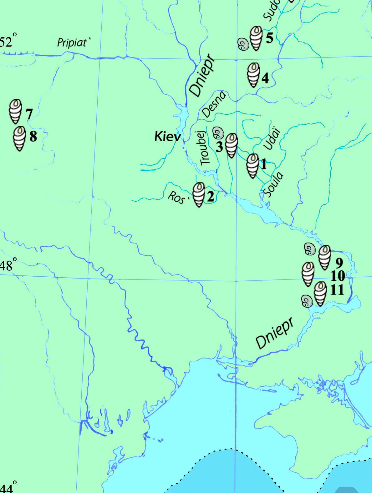
13. The source of shells
In several sites in the Dnipro River Basin, shells of different taxa, of fluvial, lacustrine and fossil origin, were used primarily as body adornment items.
Since river shells pose no supply problems, it is mainly the origin of lacustrine shells from the Black Sea and fossil deposits, which expresses their importance in the symbolic system, particularly in the field of body decoration by human groups in Ioudinovo, Timonovka 1 Mizyn, Gontsy, Mezhrich, Semenivka and the westernmost sites of Barmaki and Gorodok 2.
The use of shells from distant places which raises the ever present question of their precise origin, which varies between a lacustrine origin for Black Sea shells, the fossil deposits of the lower Dnipro basin, especially in the Nikopol region, fossils from sites in the southern Crimea Sudak region and the peninsula of Kerch, and fossil deposits from the regions of Volyn and Podolia (Gromov 1948, Efimienko 1953, Rudenko 1959, Pidoplitchko 1969, 1976, Chovkoplass 1972, Polikarpovich 1968).
Several hypotheses have been discussed concerning the appearance of distant origin shells on the sites, either by a south - northward migration, or by direct supply during a trip (Chovkoplass 1972) or by a trading system. (Gorotsov 1935, Polikarpovich 1968)
The importance of the concept of identifying a group or part of a group by certain types of Black Sea and fossil shells can be explained by the large distance to the Black Sea, to the lagoons on the edge of the Black Sea, and fossil deposits. Timonovka 1 and Ioudinovo, where seashells were dug up at the site, are the most northern sites with seashells, at a distance of about 800 km from the Black Sea. The site of Mizyn is at a distance of about 640 km, the site of Gontsy and the Semenivka sites (1, 2, 3) are about 400 km away, and Mezherich is about 340 km from the Black Sea. This distance must be even longer if we take into account the fact that the Black Sea was a lake at the time, and the ancient shoreline was more than 100 km further away from these sites than where it is at present (Iakovleva 2011).
The variety and quantity of lacustrine, fossil and fluvial shells in the sites or in parts of the site show the complexity of the concept of the symbolic system in position at the sites. The peculiarity of this system in the field of body decoration is manifested particularly by the use of remote origin shells. This can be illustrated by two points: 1. the number of different taxa of shells and their spatial distribution in the sites; 2. by the knowledge of the manufacturing process and use of lacustrine/fossil origin ornaments at several sites (Iakovleva 2005, 2006, 2011, 2013).
Indeed, with respect to the presence of shells from a distant origin, the distance of the site from the place of supply, for shells which are of lacustrine or fossil origin did not play a decisive role. This is well illustrated with respect to the Mezhich site , which is closer to the Black Sea, and yet where the only shells found were of Nassa reticulata Linnaeus and then only near hut № 1 (Pidoplitchko 1976).
At the Gonsky site, the characteristic of body decoration chosen because of the distant origin of a specific species of shells, was also highlighted by the latest discovery of a bivalve shell Cerastoderma glaucum cf. umbonatum Wood. 1850, from the Black Sea, which was found close to the hut № 5 and a seashell Dorsanum corbianum Orbigny, 1844 fossil from a bed of the Miocene, which was found at the activity area next to the hut № 3.
In fact in residential habitats of the middle Dnipro basin, there is a scarcity of lacustrine and fossil shells of specific species at Gontsy and Mezhirch as well as their absence at Dobranichivka compared to the larger number of different species (lacustrine / fossil) found in small seasonal sites of short duration at Semenivka. The repertoire of supplies of shells on these sites shows that the elements of shell ornaments were composed of Nassa reticulata Linnaeus, Cyclope neritea et Theodoxus sp. at Semenivka 2 and 3, and supplemented by Dorsanum sp. at Semenivka 2.
In this variability of species at the small sites of Semenivka, is found the consistency of ornamental elements of similar shape by Nassa reticulata Linneaus at Mezhirich and Dorsanum corbianum d'Orbigny, 1844 at Gontsy as well as by the presence of Unio shells at Gontsy, Mezhirich and at Semenivka 3 (Iakovleva 2013).
In fact, at all the sites of the middle and upper Dnipro, the use of remote origin shells is also reflected by the presence on the site of:
1. shells without perforation as raw material
2. shells with one or two perforations
3. damaged or broken shells
4. shells with traces of wear
Despite the significant variation in the number of shells in each of these sites, the various stages of their exploitation are found at Gontsy, Mizyn, Ioudinovo, Semenivka, Mezhirich. But among all these sites, only one, Mizyn, had as many as 829 shells from 9 different taxa of similar shape with manufacturing residues in place, making it a true workshop, manufacturing seashell ornaments, indicating wealth, also indicated by other types of jewellery in ivory as well as portable art and geometric mural decorations at hut № 1.
The choice of species of Nassa, Buccinum and Cerithium in pear shaped and corkscrew forms with a pointed end and a thick test (shell) which have well-marked natural ornamentation, highlights the attraction specific to Mizyn for shells adorned with good morphology (Figure 10).
In Volhynia, the site of Barmaki also confirms the importance of adornment by shells similar in form. The species of the Miocene of Volhynia (the lower levels of the middle Sarmatian) have largely supplied the shells for the residents of Barmaki (about 500 shells throughout the excavation area). Of the 104 m2 of the excavated area of the habitat, 200 shells were found, including the clearly dominate Nassa (Duplicata) cordiana Orb., and Nassa superabile Koles.
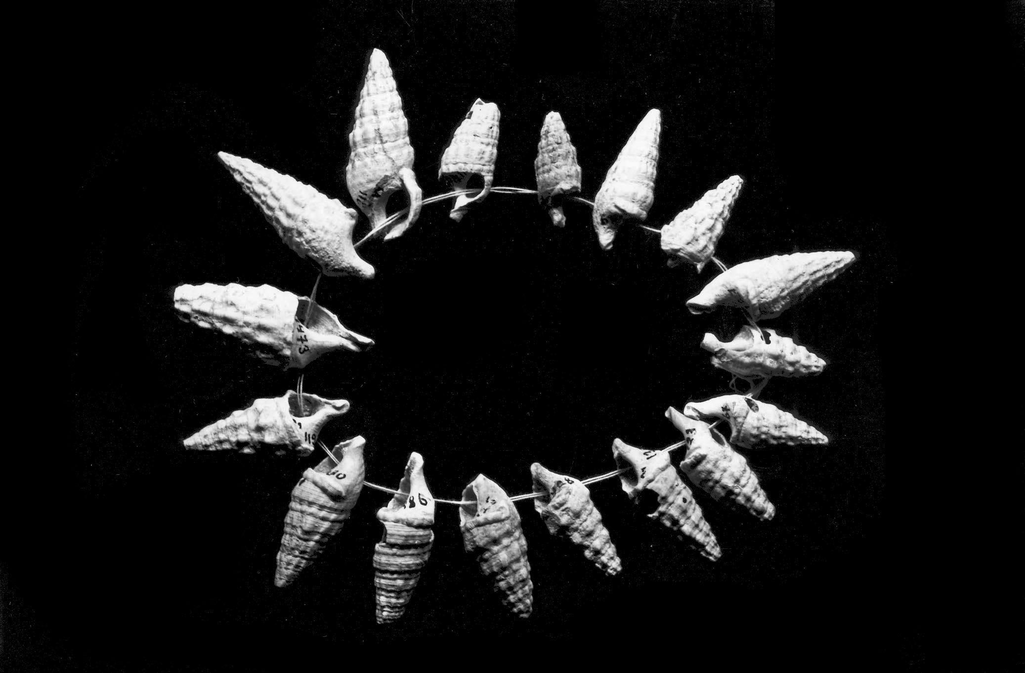
![]()
Necklace of contemporary lacustrine shells and fossils from Mizyn.
Photo: © L. Iakovleva and F. Djindjian
Source: Iakovleva and Djindjian (2012)
The shells of Gibbula sulcatopodolika Koles are infrequent, while Venerupis (Polititapes) tricuspis Eichw is represented only by a few specimens (Piacetski (1997)). A significant number of Nassa from the Miocene with a perforation for suspension as well as the presence of these shells without perforation and damaged shells, is concentrated in larger numbers in a part of the habitat, showing that the people of Barmaki manufactured of this type of jewellery on site and showed a preference for adorning themselves in this way.
Indeed, intensive manufacture of jewelry using shells of various origins, but with similar shapes, asserts the existence of a single significant tradition of adornment mode choice preferred at both Mizyn and Barmaki which are distant east/west from each other by about 500 km. The use of shells of various species from the Black Sea and the fossil deposits of the Miocene of Volhynia shows that the northern groups related to the southern regions as well as the western regions.
In conclusion, the strong preference for shells of certain taxa and the diversity of assemblages with other types of ivory jewellery items, amber, and animal teeth at several sites also reveal the complexity of body decoration perceived as reflecting a symbolic and social system. The importance of body decoration is also reflected in the existence of workshops for manufacturing ornamental elements using shells and ivory at Mizyn, ivory at Ioudinovo and amber at Mezhirich, which, perhaps, played a role as the specialized production centre for these objects.
14. The source of amber
Amber objects are present in practically all the sites in the Dnipro basin. Although this raw material is available in quantity in the middle Dnipro basin, including in the areas of Kyiv and Kanev, their presence in the sites is highly variable. Kyiv-Kirilovskaia, Gontsy, Semenivka 2, Ioudinovo, Chulatovo 2, Elisseevichi 1 had amber objects in small quantities. But at Dobranichivka was found a highly schematic representation of a female, realised by taking advantage of the natural form of a large piece of dark amber, which could be worn as a pendant. Dobranichivka, Mizyn and Mezhirich are quite important users of amber in their habitats.
Unfortunately, the poor state of conservation of this material reduces the evidence of both its use, in the presence of natural pieces of amber at the sites and the discovery of artefacts in more or less preserved amber (the female statuette of Dobranichivka, pendants and beads of Dobranichivka, Mizyn, Mezhirich, Semenivka 2). Only one site, Mezhirich, illustrates the extent of the use of amber, found in four huts: 70 specimens in the hut № 1; 228 specimens in the hut № 2; 40 specimens in the hut № 3 (Pidoplitchko (1976)).
15. The Mizynian system
In Eastern Europe, in parts of the upper and middle Dnipro River and their tributaries, a population, the Mizynian (sometimes called 'eastern Epigravettian'), is known by the assemblies of the same technocomplex in a short period of time from ca 15 000 BP to 14 000 BP. This definition is based on an extensive series of AMS 14C dating and critical comparison with the large series of old and recent conventional dates from several Ukrainian and Russian laboratories.
In the current state of knowledge, the territory occupied by Mizynian sites follows a north south axis (between latitude 53°12'N / 34°18' E and 49°38'N / 31° 21'E). The most characteristic features are:
![]() residential outdoor habitats with complex habitat structures, built from a large number of mammoth bones, according to a very elaborate architecture at Gontsy, Dobranichivka, Mezhirich, Ioudinovo, Mizyn, Suponevo, Bujanka 2, Elisseevichi 1, 2, Timonovka 1, 2.
residential outdoor habitats with complex habitat structures, built from a large number of mammoth bones, according to a very elaborate architecture at Gontsy, Dobranichivka, Mezhirich, Ioudinovo, Mizyn, Suponevo, Bujanka 2, Elisseevichi 1, 2, Timonovka 1, 2.
![]() temporary travelling sites, with or without the collection and storage of piles of mammoth bones, but without buildings, revealing travel radiating out from the home territory for the supply of various raw materials (flint, shells, ochre, bones), specialised hunting, and the exchanges necessary for the life of the group, such as at Bougorok, Jouravka, Fastiv, and Semenivka.
temporary travelling sites, with or without the collection and storage of piles of mammoth bones, but without buildings, revealing travel radiating out from the home territory for the supply of various raw materials (flint, shells, ochre, bones), specialised hunting, and the exchanges necessary for the life of the group, such as at Bougorok, Jouravka, Fastiv, and Semenivka.
![]() an economy primarily based on the mammoth (food resources, fuel, building materials, raw material for tools and weapons).
an economy primarily based on the mammoth (food resources, fuel, building materials, raw material for tools and weapons).
![]() the importance of making the skins and furs of different animals hunted (deer, horse, bison, musk ox, arctic fox, wolf, bear, hare, groundhog) of vital use for the protection and coverage of dwellings and for clothing.
the importance of making the skins and furs of different animals hunted (deer, horse, bison, musk ox, arctic fox, wolf, bear, hare, groundhog) of vital use for the protection and coverage of dwellings and for clothing.
![]() additional food resources, including reindeer at Gontsy, Dobranichivka, Mezhirich and Mizyn and horses at Mizyn and Fastiv. Hunting of marmots in summer was practiced at Gontsy and Jouravka.
additional food resources, including reindeer at Gontsy, Dobranichivka, Mezhirich and Mizyn and horses at Mizyn and Fastiv. Hunting of marmots in summer was practiced at Gontsy and Jouravka.
![]() A well developed and diverse tool set using hard animal matter such as bone, ivory and antler:
A well developed and diverse tool set using hard animal matter such as bone, ivory and antler:
![]() antler: hammers, hammers and pierced sticks.
antler: hammers, hammers and pierced sticks.
![]() long bones and the metapodes and phalanges of the polar fox, wolf and hare: awls, pins, needles.
long bones and the metapodes and phalanges of the polar fox, wolf and hare: awls, pins, needles.
![]() ivory: eyed needles.
ivory: eyed needles.
![]() mammoth tusk tip: spikes, pickaxes.
mammoth tusk tip: spikes, pickaxes.
![]() mammoth ribs: knives.
mammoth ribs: knives.
![]() a rather plain and stable flint industry (unguiform (claw shaped) scrapers, simple burins, backed bladelets) knapped following more of a lamellar than a laminar procedure, and standardised.
a rather plain and stable flint industry (unguiform (claw shaped) scrapers, simple burins, backed bladelets) knapped following more of a lamellar than a laminar procedure, and standardised.
![]() schematic and geometric portable art on ivory.
schematic and geometric portable art on ivory.
![]() objects of jewellery in ivory.
objects of jewellery in ivory.
![]() jewellery objects made with the teeth of selected animals (reduced to some species of carnivores and bovids).
jewellery objects made with the teeth of selected animals (reduced to some species of carnivores and bovids).
![]() the use of amber for jewellery and sculpture.
the use of amber for jewellery and sculpture.
![]()
Map of the upper palaeolithic sites of the Dniepr basin having jewellery using lacustrine or fossil shells:
1. Gontsy
2. Mezhirich
3. Semenivka
4. Mizyn
5. Ioudinovo
6. Timonovka
7. Gorodok
8. Barmaki
9. Doubovaia Balka
10. Kaistrova Balka
11. Osokorivka.
Photo: © L. Iakovleva and F. Djindjian
Source: Iakovleva and Djindjian (2012)
![]() shell ornaments made of lacustrine and fossil species preferably from distant locations (Figure 11)
shell ornaments made of lacustrine and fossil species preferably from distant locations (Figure 11)
![]() various geometric decorations, complex or simple, engraved on utilitarian objects, on jewellery, on statuettes, on mammoth tusks and bones
various geometric decorations, complex or simple, engraved on utilitarian objects, on jewellery, on statuettes, on mammoth tusks and bones
![]() geometric decorations painted on the bones of mammoths and on the hut walls.
geometric decorations painted on the bones of mammoths and on the hut walls.
![]() architectural decoration of the huts on selected mammoth bones
architectural decoration of the huts on selected mammoth bones
![]() The use of mineral colourants such as haematite (red ochre) or jarosite (yellow ochre)
The use of mineral colourants such as haematite (red ochre) or jarosite (yellow ochre)
The winter season for the supply of carnivorous fur is also represented ( Verechagin and Kusmina 1977). The existence of pits dug in the permafrost confirms the hypothesis of L. Binford (Binford 1993) drawn from the comparative ethnographic Inuit populations, that they were for use in the summer (frozen soil in the bottom of the pit acting as a refrigerant) and not winter (when the cold, dry climate allows conservation outdoors but hoisted in the air to avoid predation by carnivores).
Residential sites were occupied at different seasons, with food storage capacities and building materials in the pits. From the sites many trips were made to get raw materials, for specialised hunting, or for trading necessary for the life of the group (cf. planned logistics strategy (Binford 1980) and semi-sedentary strategy. (Iakovleva 2000, 2003, Iakovleva and Djindjian 2000, 2005) The movements of human groups are revealed by the existence of small short term camp sites used while travelling, without mammoth bone structures and also by the use of non-local raw materials of certain types of flint (like dark chocolate flint or chalcedony), transparent rock crystal (from the Kyiv region, near Smela), dark grey rock crystal from the Kanev region, as well as amber and shells, which have been widely used as objects of body adornment in the basin sites the Dnipro.
The use of shells of various taxa from the Black Sea highlights the connection of the northern groups with the southern regions. In this socio-cultural system residential habitats appear as central sites, in charge of cultural identification, and social and spiritual group and intergroup relations in their geographic area.
16. Conclusion
In the study of the European Upper Palaeolithic, the Mizynian is probably the best known culture in terms of habitat and territory (Iakovleva 2009b). The reason is the exceptional conservation in loess sequences of bone huts which are the structures of the best preserved prehistoric habitats. These mammoth bone huts are so spectacular that they have been, since the 1950s, the focus of archaeologists (Pidoplitchko 1969, Abramova 1995b, Abramova et al 1997a). The scientific interest now is to understand the origin of the system of habitats and the habitats at the origin of the settlement of the territory, in order to characterise the system based on the mammoth economy.
This information can only be registered with the complete excavation of a site, such as we did in Gontsy since 1993, and with the methods of modern archeology. It is then possible to reconstruct not only several mammoth bone huts and associated pits, but the whole habitat with its huts, pits, fireplaces, work areas, rubbish and discards areas, butchery sites, and their interconnections.
The major role of the vast accumulation of mammoth bones has been stressed at Gontsy, and this role could be generalised by thoroughly searching the archives of the excavations of sites surveyed since the beginning of the twentieth century, and will definitely be demonstrated by the careful study of new excavations in areas surrounding headlands that house the mammoth bones hut habitats of the sites of the middle and upper basin of the Dnipro.
This work is the result of a scientific program of collaboration between the Institute of Archaeology of the National Academy of Sciences of Ukraine and the laboratory CNRS UMR 7041 ArScAn in France: 'Excavations at Gontsy for research of the settlements of the recent upper Palaeolithic Dnipro basin.' The project is funded by the program 204 of the Department of Archaeology of the French Ministry of Foreign Affairs since 1994, the project PAI Dnipro No. 09862VJ, the Econet project no 10148QD , and the Association 'Archeology of Eurasia'.
References
- Abramova Z., 1995a: L'Art paléolithique d'Europe orientale et de Sibérie, Grenoble, Jérôme Millon.
- Abramova Z., 1995b: Le site paléolithique supérieur d'Ioudinovo, 1. Saint-Petersbourg, Nauka (in russian).
- Abramova Z., Grigorieva G., Christensen M., 1997a: Le site paléolithique supérieur d'Ioudinovo, 3. Saint-Petersbourg, Nauka (in russian).
- Abramova Z., Grigorieva G., 1997b: Le site paléolithique supérieur d'Ioudinovo, 3. Saint-Petersbourg, Nauka (in russian).
- Binford L., 1980: Willow smoke and dog's tails: Hunter-Gatherer Settlement Systems and Archaeological Site Formation, American Antiquity, 45(1) : 4–20.
- Binford L., 1993: Bones for stones : considerations of analogues for features found on the Central Russian plain. In : O. Soffer and N. Praslov (eds), From Kostienki to Clovis. Upper Paleolithic - Paleo-Indian adaptations, New-York, Plenum Press, p. 101–124.
- Boriskovskii P., 1953: Paleolit Ukraini, Materiali i Issledovaniaya po Arheologii SSR 40, Moscow-Leningrad: Izdatel'st vo An SSSR
- Brusov A., 1940: Gonthovskaia stoianka (The Gontsy site), Review of Soviet Archaeology, 5 : 88–92 (in Russian).
- Chovkoplass I., 1955: Dobranicevskaja paleoliticeskaja stojanka. (The palaeolithic site of Dobranichivka), Kratkie litic soloscenija, Instituta Istorii Material noij Kultury 53 : 32–45 (in Russian).
- Chovkoplass I., 1965: Le site de Mezine, Kiev, Naukova Dumka (in Russian).
- Chovkoplass I., 1972: Dobranitchevkaia stoianka, Kiev (The Dobranichivka site near Kiev), MNA, 185 : 177–188 (in Russian).
- Djindjian F., 2014: Identifying the hunter-gatherer systems behind associated mammoth bone beds and mammoth bone dwellings Quaternary International, (2014), http://dx.doi.org/10.1016/j.quaint.2014.07.006
- Efimienko P., 1953: Les sociétés primitives, 3o édition (in Russian).
- Gorodtsov V., 1926: Isledovanie Gontsovskoi paleolititcheskoi stoianki v 1915, Trudi otdelenia archeologii Instituta archeologii i iskustvovedenia, RANION, 1 : 5–35 (in Russian).
- Gorodtsov V., 1935: L'organisation sociale et économique des anciens habitats du site paléolithique de Timonovka, Ethnographie Soviétique , 3 : 3–13 (in Russian).
- Gromov V., 1948: Paleontologitcheskoe i archeologitcheskoe obosnavie stratigrafii kontinentalniche otlogenij thetvertichnogo perioda na territorii SSSR (Palaeontology and archaeology). (For argumentation of the stratigraphy of the quaternary sedimentation on the SSSR territory). Trudi Geologitheskogo Instituta AN SSSR. (The researches of the Institute of Geology of the Academy of Sciences of SSSR), Serij Geologii, 17(64) (in Russian).
- Iakovleva L., 1999: Les datations 14C des habitats de la grande plaine russe orientale, In: J. Évin, Ch. Oberlin, J.P. Daugas & J.F. Salles (eds.), 3e Congrès International 14C et Archéologie, Lyon, Avril 1998, Paris, Mémoire de la Société, Préhistorique Française 26 et GMPCA, pp 123–131.
- Iakovleva L., 2000: Poselenia is jitlami is kistok mamonta Dniprovs'kogo baseiny. (Mammoth bone dwelling settlements of Dnepr bassin), Archeologia, 2 : 72–83 (in Ukrainian).
- Iakovleva L., Djindjian F., 2000: The new excavations of the Gontsy site (Ukraine) in the context of Épigravettian camp-sites of the Dnepr basin. In : D. West (ed.), Proceedings of the International Conference on Mammoth Site Studies, Archaeopress, Lawrence, University of Kansas. Publications in Anthropology 22 : 85–94.
- Iakovleva L., Djindjian F., 2001: New data on mammoth bone dwellings of Eastern Europe in the light of the new excavations of the Ginsy site (Ukraine), The World of Elephants - International Congress, Rome 2001
- Iakovleva L., 2003: Les habitats en os de mammouths du paléolithique supérieur d'Europe orientale : les données et leurs interprétations. In : S.A. Vasiliev, O. Soffer and J.K. Kozlowski (eds) (2003), Perceived landscapes and built environments : the cultural geography of late palaeolithic Eurasia, Archaeopress,BAR International Series 1122 : 47–57.
- Iakovleva L., 2005: Les parures en coquillages au Paléolithique supérieur récent dans les territoires de peuplement du bassin du Dniepr, Archemetriai Muhely. Elektronikus folyoriat, 4 : 26–37.
- Iakovleva L., Djindjian F., 2005: New data on mammoth bone dwellings of Eastern Europe in the light of the new excavations of the Ginsy site (Ukraine), Quaternary International, 126–128 (2005) 195–207
- Iakovleva L., 2006: Le système symbolique des parures dans les peuplements du Paléolithique supérieur récent du bassin du Dniepr. In: La Cuenca Mediterranea durante el Paleolitico Superior 38 000 – 10 000 anos, U.I.S.P.P. Commission 8. Fundation Cueva de Nerja, p. 32–44.
- Iakovleva L., 2009a: Le concept de territoire à partir des données des sites des régions du Dniepr au Paléolithique supérieur récent en Europe orientale, In: F. Djindjian, J. Kozlowski & N. Bicho (eds.), Le concept de territoires pour les chasseurs cueilleurs du Paléolithique supérieur européen, Archaeopress, BAR, International Series 1938 : 41–62.
- Iakovleva L., 2009b: L'art mézinien en Europe orientale dans son contexte chronologique, culturel et spirituel, L'Anthropologie, 113 : 691–752.
- Iakovleva L., 2010: Les fouilles paléolithiques en Eurasie au XXo siècle dans leur contexte historique, in: S. de Beaune (ed.), Écrire le passé, Colloque 'L'écriture de l'histoire… et de la préhistoire d'hier à aujourd'hui', 14 –16 mai 2008, Lyon, Paris, CNRS, p. 181–194.
- Iakovleva L., Djindjian F., Maschenko E., Konik S., 2010: The mammoth bone bed of the mammoth bone hut Late Upper Palaeolithic camp-site of Gontsy (Ukraine): Recent results of the 2004–2006 excavations. In: Lazarev, P., Boeskorov G., Maschenko E. (eds.), Proceedings of the IV International mammoth Conference, IVo Mammoth International Conference, Iakutsk (Sibérie), 18–22 June 2007, Iakustsk, 2010, p. 150–158.
- Iakovleva L., 2011: Le parure en coquillages comme d'un élément d'un système socio -symbolique du décore corporelle et vestimentaire (d'après des donnes des sites du paléolithiques supérieur récente d'Ukraine), Archéologie et histoire ancien de l'Ukraine, 6 : 91–98.
- Iakovleva L., Djindjian F., Maschenko E., Konik S., Moigne A., 2012: The late Upper Palaeolithic site of Gontsy (Ukraine): A reference for the reconstruction of the hunter-gatherer system based on a mammoth economy, Quaternary International, 255 (2012) 86-93
- Iakovleva L., Djindjian F., 2012: L'habitat à cabanes en os de mammouths de Gontsy (Ukraine), Colloque UISPP 'Modes de contacts et de déplacements au Paléolithique eurasiatique', Liège mai 2012, Volume: ERAUL no 240 Université de Liège.
- Iakovleva L., 2013: L'Art des origines en Ukraine, Kiev, Starodavni Svit (in Ukrainian).
- Iakovleva L., Djindjian F., 2014: The five mammoth bone huts of the Upper Palaeolithic camp-site of Gontsy (Ukraine), Abstract Book of the VIth International Conference on Mammoths and their Relatives, S.A.S.G., Special Volume 102: 71.
- Kaminski F., 1878: Sledi drevneiychy epoki kamenogo veka por. Sule see pritokam (Les vestiges de l'âge de Pierre dans la vallée de la Soula et de ses affluents). Troudi III arkeologitcheskogo siesda, 1898, T.I. Kiev, Actes du IIIo Congrès Archéologique, Kiev, 1898 (in Russian).
- Kozlowski J., 2003: Mammoth bone accumulations and dwelling structures. Discussing some arguments around Krakow-Spadzista B street. In : S.A Vasiliev, O. Soffer & J.K. Kozlowski (eds),Perceived landscapes and built environments : the cultural geography of late palaeolithic Eurasia, Archaeopress, BAR International Series 1122 : 59–64.
- Levitski I., 1947: Gontivska paleolitichna stojanka za danimi doslidjen' v 1935. (The palaeolithic site of Gontsy from data of 1935 excavations), Palaeolithic and Neolithic of Ukraine, Kiev. 1, 197–248 (in Ukrainian).
- Maschenko E., Gablina S., Tesakov A., Simakova A., 2006: The Sevsk woolly mammoth (Mammuthus primigenius) site in Russia : Taphonomic, biological and behavioral interpretations. Third International Mammoth Conference, Quaternary International, 142–143 : 147–165.
- Oliva M., 2009: Milovice : site of the mammoth people below the Pavlov hills, Studies in Anthropology, Paleoethnoplogy, Paleontology and Quaternary Geology , 27.
- Piacetski V., 1997: Le commencement des fouilles de l’habitat paléolithique de Rovno (Barmaki). Moscou, Archéologie de Russie, 1 : 151–161.
- Pidoplitchko I., 1969: Les habitats du Paléolithique supérieur en os de mammouth en Ukraine, Kiev, Nauka (in Russian).
- Pidoplitchko I., 1976: Les habitats en os de mammouths de Mejeriche, Kiev, Nauka (in Russian)
- Pidoplitchko I., 1998: Upper Paleolithic Dwellings of Mammoth Bones in the Ukraine, traduit du Russe, édité et avec une introduction de P. Allsworth-Jones, British Archeological Reports (BAR), International Series 712, Oxford : Archaeopress, 1998, 276 p., 41 fig., 23 tabl.
- Pitulko V., 2011: The Berelekh quest : A review of forty years of research in the mammoth graveyard in northeast Siberia, Geoarchaeology, 26(1) : 5–32.
- Polikarpovich K., 1968: Paleolit Verchnigo Podneprovia (Paléolithique du Dniepr supérieur), Minsk (in Russian).
- Roudenko A., 1959: Morskie moliuski iz Mezinskoi stoianki. (Mollusques marins du site de Mézine), Kiev, KSIA, Akademi de la Sciance Ukr. RSS 8 : 110–112 (in Russian).
- Sablin M., 2002: Paleozoologia stoianok Verknei Desni : novie danie. (Paléozoologie des sites de la Desna supérieur), Papiers colloque international – Paléolithique supérieur, Saint-Petersburg, p. 107–109.
- Scherbakivski V., 1919: Roskopki paleoliticheskogo selicha v s. Gontsach lybianskogo povity v 1914 i 1915 rr. (Les fouilles de l'habitat paléolithique de Gontsy, près de Lubny, en 1914 et 1915)Zapiski Ukrainskogo naykovogo tovaristva doslidjenna i okchoroni pam'iatok starovini ta mistetstva na Poltavchini, (Notes de l'association scientifique ukrainienne pour la recherche et la conservation des sites et de l'art préhistorique de la région de Poltava), Poltava 1 : 61–78 (in Ukrainian).
- Scherbakivski V., 1926: Eine paläolithische Station in Honci, Die Eiszeit, B.III, H. II, Leipzig (in German).
- Verechagin N., Kusmina I., 1977: Les restes de mammifères des sites paléolithiques des vallées du Don et de la Haute Desna. Faunes de mammouths de la plaine russe et de Sibérie orientale. Saint-Pétersbourg, Publication ZIN Académie des Sciences, 72 : 77–83 (in Russian).
- Sergin V., 1981: Roskopki jilicha na Gontaskom paleoliticheskom poselenii, KCIA, (Comptes Rendus de l'Institut d'Archéologie) 165 : 43–50 (in Russian).
- Sergin V., 1983: Nasnathenie bolchich kosiajstvenich iam na paleoliticheskich poseleniijak, KCIA, (Comptes Rendus de l'Institut d'Archéologie) 173 : 23–30 (in Russian).
- Soffer O., 1985: The Upper Paleolithic of the Central Russian Plain, Academic Press, 1st edition (1985)
- Valoch K., 1996: The Upper Paleolithic of the Central Russian Plain, Academic Press, 1st edition (1985)
- Velichko A., Grekhova L., Gubonina Z., 1977: L'environnement de l'homme préhistorique des sites de Timonovka, Moscou, Nauka (in russian).
- Velichko A., Grekhova L., Udarcev V., 1997: Nouvelles données en Archéologie, géologie et paléogéographie de la station d'Elisseevichi, Paléoécologie de l'homme ancien, Moscou, pp 96–105.