Back to Don's Maps
 Back to Archaeological Sites
Roc de Marcamps and la grotte des Fées
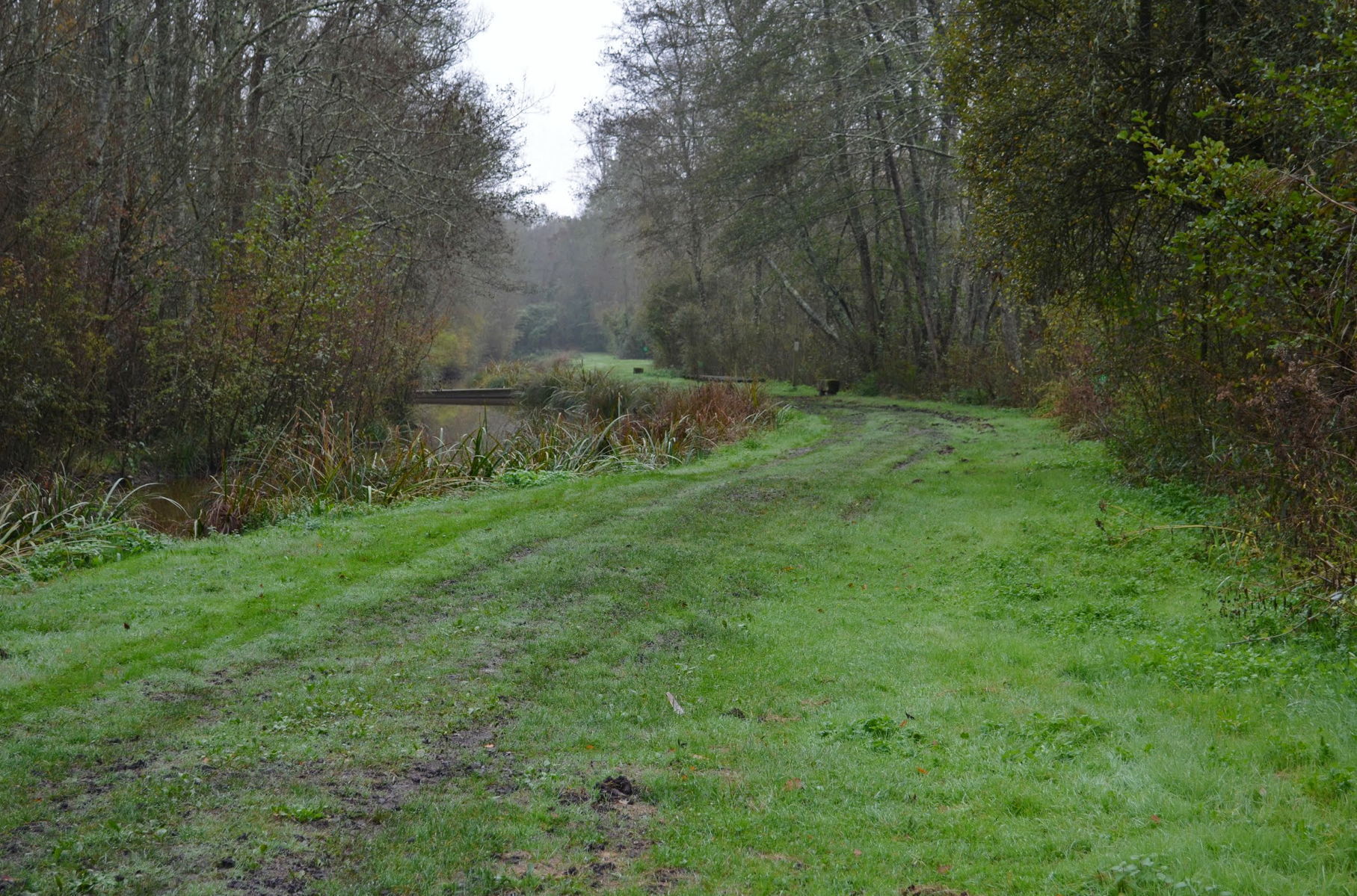
Moron River scene not far from la grotte des Fées
Photo: © alaindejollet via Google Earth and Panoramio.
Discovered in 1873 by F. Daleau and E. Maufras, la grotte des Fées is located in the Moron valley near the cave of Pair-non-Pair. It is a small cave that has its opening at the top of a Stampian (early Oligocene age) limestone cliff . Daleau undertook extensive excavations there and collected a handsome middle and upper Magdalenian lithic industry as well as faunal remains. He described the stratigraphy in his 'tour diaries' and in Daleau (1874).
The Roc de Marcamps was discovered just below the prehistoric cave of la grotte des Fées. It is a Magdalenien archaeological site. Both these sites are very close to the cave of Pair-non-Pair.
Text above adapted from http://visites.aquitaine.fr/roc-de-marcamps
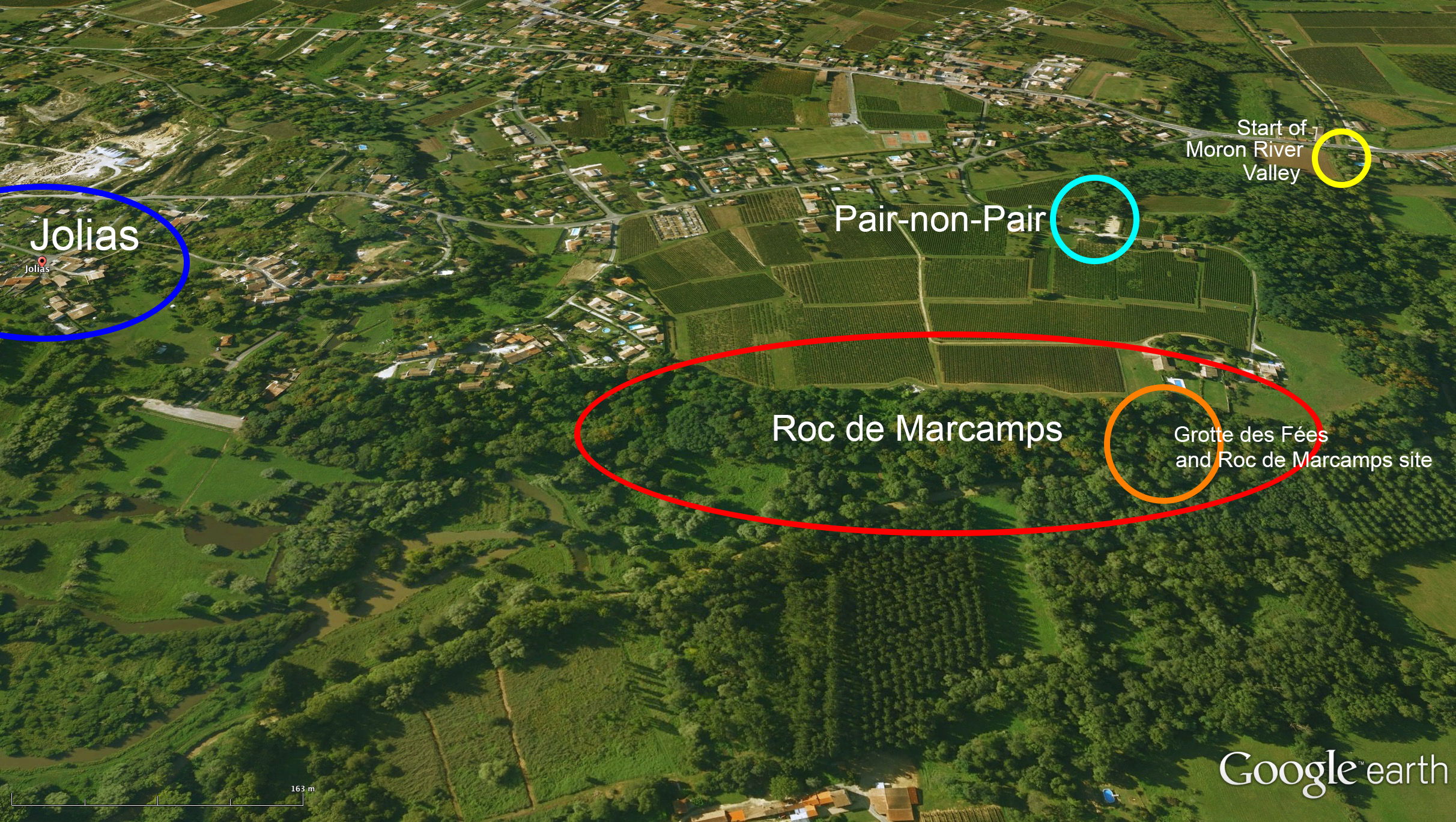
General view of Roc de Marcamps and la grotte des Fées.
Photo: Google Earth, imagery from 2006
Additional information to locate the sites by Don Hitchcock, based on the description of Daleau (1874)
Note that we are looking from north to south, so that la grotte des Fées and Roc de Marcamps both face north, which makes this a most unusual habitation. Most abris are chosen, where possible, to have a southerly aspect, to gain the warmth of the sun in winter.
The Moron River valley starts (going upstream) where the Moron is crossed by the major road, D669. Beyond that point, going downstream, it travels for a few kilometres across the river flats bordering the Dordogne, in a course which appears to have been modified into two distinct straight sections, presumably in the interests of ease of agriculture, until it joins the Dordogne.
From the start of the valley then, going upstream, we may see as Daleau says below:
The valley of the Moron, oriented north - south (at its beginning), is about 300 metres wide at this point. It narrows a little in front of the Grotte (where the Moron River has by now changed course by 90 degrees, and is at this point oriented east - west) and thus continues for a kilometre, where it widens suddenly (in front of Jolias) and reaches a width of about 800 metres. (This widening is now a nature reserve, a beautiful wetland area, a refuge for many species of animals, birds, and plants)
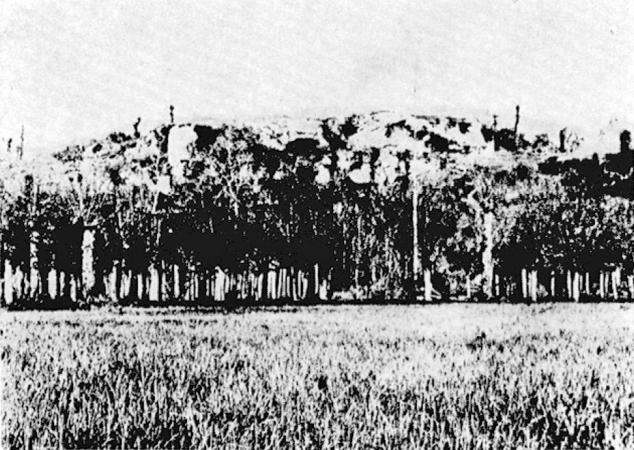
General view of Roc de Marcamps and la grotte des Fées in 1900.
We can see here and from the satellite photo above that the residents of the habitation had the advantage of looking out over what was probably a pasture, suitable for grazing by horses and other ruminants, no doubt one of the reasons it was favoured as a dwelling site.
In addition, grazing animals could have been hunted west along the wider river valley upstream to where it narrows near la grotte des Fées, with hunters there at the constriction waiting to throw their 'darts' from their spear throwers, and bring down the game.
Photo: Allain et al. (1985)
Grotte des Fées
Situated at the Roc, commune of Marcamps
Discovery
About five years ago, I picked up a certain amount of flints and charred bones on the western slope of the hill known as le Roc, which dominates the left bank of the river Moron.
Later, on 11th April 1873, I discovered at Jolias, situated at most one kilometre from le Roc, a cave-shelter, which I excavated in company with my colleague M. Gassies. The opening of this abri was situated N-NE. Until then I had refused to believe that a cave oriented a cave oriented in this way, especially in our region, could have been inhabited in the age of the Reindeer, because of the exposure to rain and winds, and such areas seldom enjoy sunlight during the cold season. The discovery of Jolias turned my suppositions upside down.
The remains of flint that I had found earlier at the Roc made me sensible of the existence of a habitation nearby.
I directed my research to the southern part of the hillside. It is very likely that caves, or at least a large abri existed there; but limestone rests there on a very friable sandstone which, undermined by atmospheric influences, and badgers, forced the collapse of the upper vault of the cave or abri, because huge limestone blocks are still in place at the site.
On October 3, 1873, I went to le Roc with my colleague M. Madras. After making a sounding without any results, we learned from an old farmer only a hundred paces away, that in the Western part was a Clotte (the word means grotte in the Bourgeais patois ), an area used by badgers, and that from time immemorial the place had been called the Clotte des Fées. This name sounded pleasant to our ears, and we proceeded to the place the farmer indicated by following a path made by badgers through the thicket.
We arrived on a kind of platform, with the entry to a spacious cave offered to our sight; its appearance and general layout reminded us of that of les Eyzies. The first sod showed us that the site had been inhabited in the prehistorical period. Permission to excavate was asked of Messrs. Castanet and Viaud, the owners; it was graciously given us. I take this opportunity to express my gratitude here to these two gentlemen.

Lithic industry of la grotte des Fées
1. Small flint saw, the lower part of which served as a handle.
2. Knife-scraper showing some wear on the upper part.
3. Flint tool with the head curved into the shape of a sickle, retouched especially at the top.
4. Flint reworked on a spearhead, as a knife, completely retouched.
5. Small flint blade with a square end, retouched on the top and one of the sides, the other edge very sharp.
6. Small flake retouched on one side from the base of a scraper.
7. completely retouched scraper-knife, with a rounded head (Eyzies type).
Photo and text: Daleau (1874)
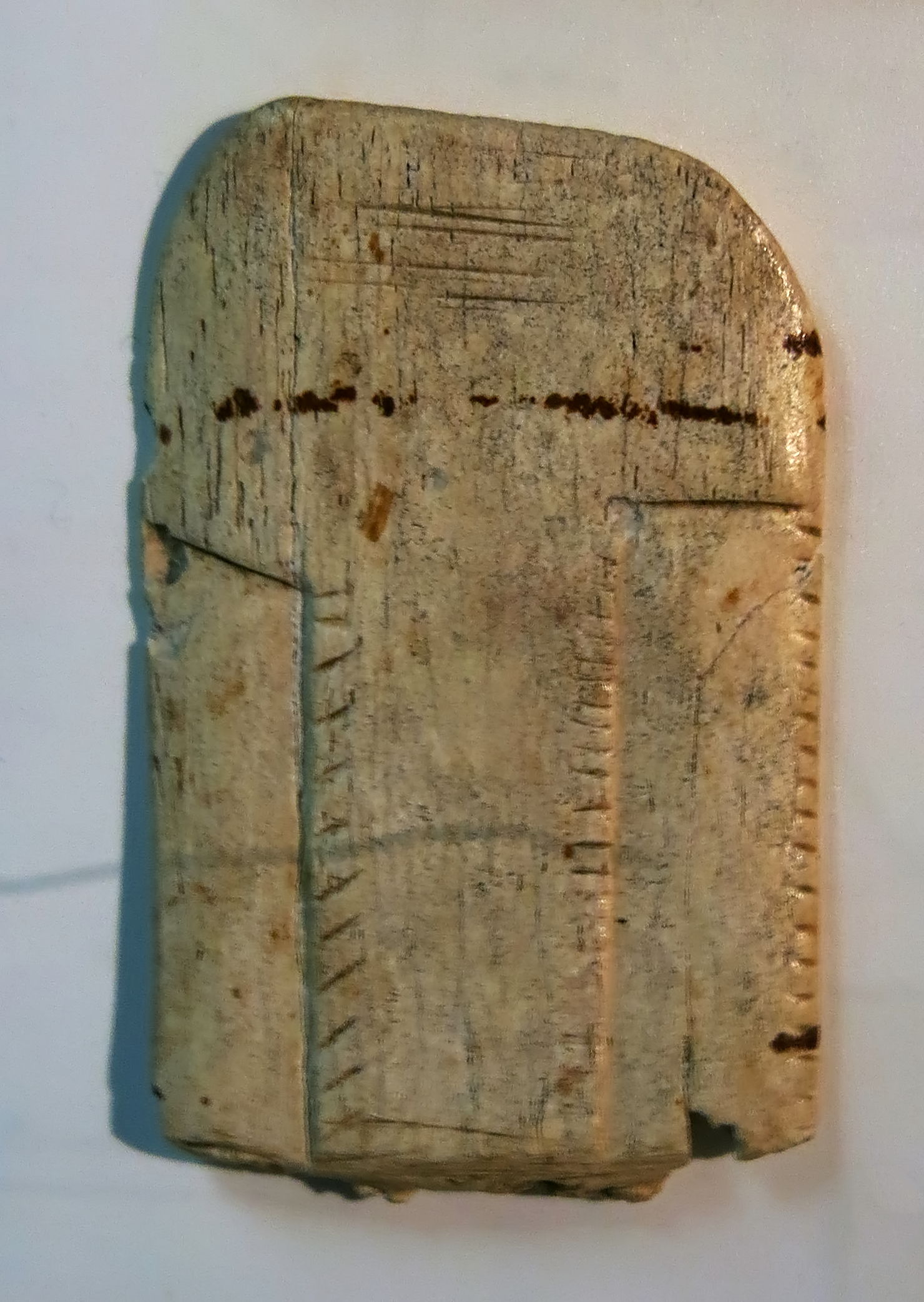
Carved bone in a roughly rectangular format from la grotte des Fées, see below.
Photo: Don Hitchcock 2015
Source: Original, Musée d'Aquitaine à Bordeaux
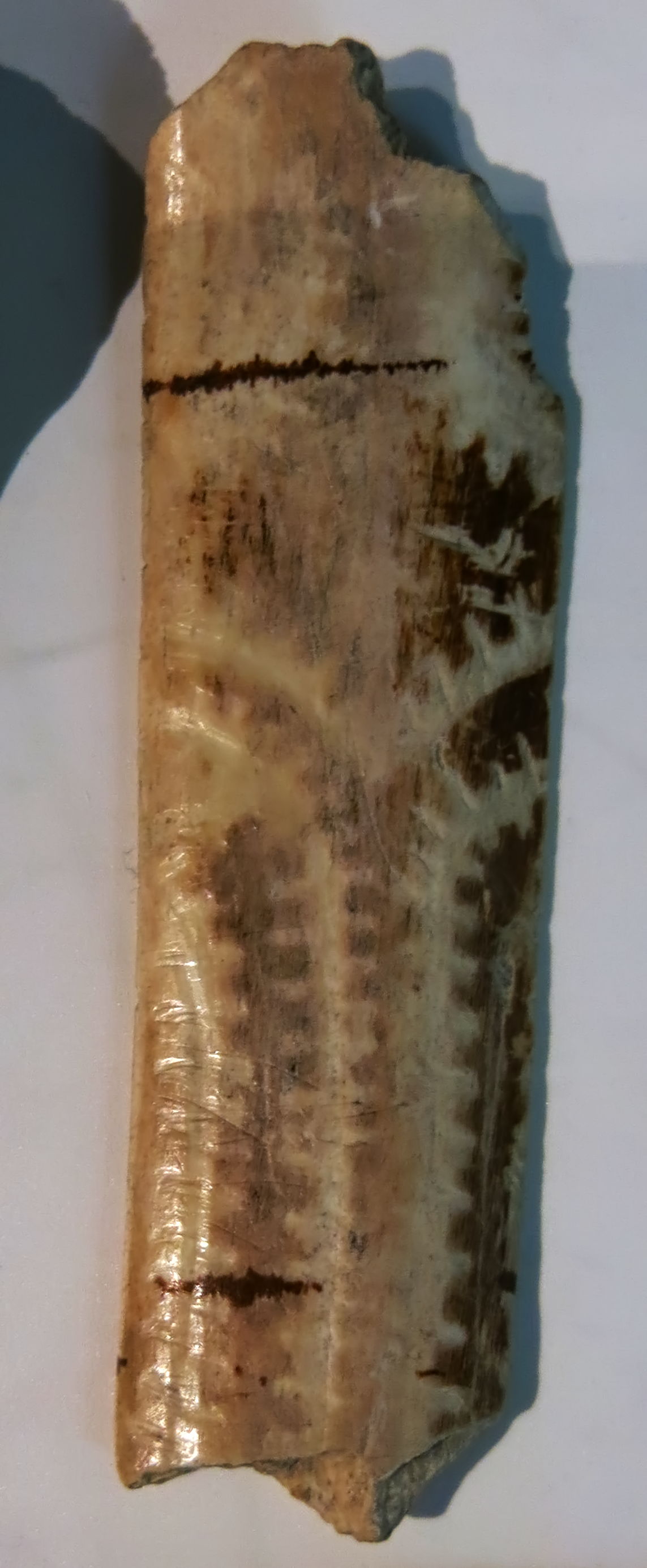
Bone with a very interesting low relief pattern from la grotte des Fées, see below.
The design has elements of vegetative patterns.
Photo: Don Hitchcock 2015
Source: Original, Musée d'Aquitaine à Bordeaux
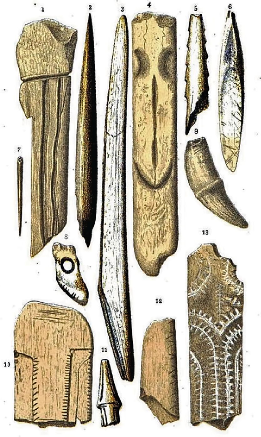
Bone and antler industry of la grotte des Fées
1. Bone blade, incised to extract needles.
2. Bone Awl.
3. Reindeer antler harpoon, with a longitudinal groove on each side, the lower part bevelled to allow fitting to the spear shaft.
4. Oblong tool made of reindeer antler, with a slightly blunted head, the base flattened in the form of a lissoir, or smoother for hides. The upper side has a very rough design of a human head.
5. Arrow-head with side indentations in a toothed pattern.
6. Small reindeer antler spear point with longitudinal grooves, the upper part sharp, but broken off on one side, the lower part bevelled for attachment to the shaft of the spear.
7. Unbroken needle in bone.
8. Ruminant incisor pierced with a hole for suspension from a cord, with six very regular incisions on the anterior part of the crown.
9. Whistle made from a wolf canine, cut at the end of the root of the tooth.
10. Bone plate, polished, rounded at the top and cut off squarely at the base. Towards the centre, there are two rows of very regular side notches, as well as regular notches on the right hand side.
11. A triangular headed arrowhead, with ornamentation.
12. Perfectly polished bone fragment with ornamental notches on the right hand side.
13. Polished blade, decorated on the surface with small parallel grooves
Photo and text: Daleau (1874)
Topography
The valley of the Moron, oriented north - south, is about 300 metres wide at its beginning. It narrows a little in front of the Grotte and thus continues for a kilometre, where it widens suddenly (in front of Jolias) and reaches a width of about 800 metres.
Towards the centre of this valley flows a stream called the Moron, which, after traveling 15 kilometres from its source, flows into the Dordogne, 4 kilometres East of Bourg. This stream, just a small stream or almost dry during summer, overflows during winter, and the water then reaches almost entirely across the valley.
This valley, with its brook well stocked with fish, and with broad pastures, had been perfectly chosen by our cave-dwellers, and certainly, as we have already foreshadowed with M. Gassies in our brochure on Jolias, lake cities had existed there after the Reindeer Age, because there are few valleys as well placed, in our region, to receive lake dwelling inhabitants who, however, have left remnants of their industry in all the high plateaus surrounding this valley. I found many fragments of pottery and polished axes, and quite recently one of my friends collected a magnificent bronze axe there.
Description of the Cave
La Grotte des Fées, located almost on the steep slope of hillside overlooking the left bank of Moron, has its entrance directed to the west. The altitude of its original ground level is 20 m 68 cm and 17m 76 cm above the current bed of the Moron river. It is in lower Miocene limestone, with a width of 5m 90 cm, depth of 6 m 20 cm, and a height of 2 m 30 cm. Above the roof of the cave, the rock still has a thickness of 2 m 58cm.
The ground before the operation was nearly flat, though much higher at the entrance than at the far end, earth at the entrance had been deposited there after being dug out by foxes and badgers from further into the cave.
First layer - The first layer had been altered to some extent by shepherds and animals, and consisted, for the most part, of ashes sometimes red, sometimes gray or black, ranging from 35 to 45 cm thick. It contained:
l. A fragment of human skull;
2. The remains of a freshwater turtle;
3. Debris of coarse pottery, with quartz grains and broken shells in the mix;
4. Tiles fragments and remnants of pottery from the same period;
5. The major part of a very thin glass bottle, with inclusions of small air bubbles;
6. Pottery and bones from the same period;
7. A bronze coin of M. Antoninus;
8. A double tournois of Louis XIII;
9. An iron knife blade;
10. flint and charred bones from the lower layers.
Immediately below this last layer was a kind of felting, made up of living and decomposed roots.
Second layer - Stalagmite from 2cm to 15 cm thick that vigorous roots of trees on the surface were able to cross. This layer covering the whole ante-historical section contained, in a kind of earthy pulp of which it was composed, the following remains:
1. Unidentifiable bird and fish debris
2. Various terrestrial molluscs:
Helix aspersa
Helix nemoralis
Helix cornea
Helix hispida
Helix lapicida
Cyclostoma elegans
3. Flint and charred bones.
Third layer - Arriving at the third layer, I found the debris left undisturbed by the inhabitants. This was 25 cm to 45 cm thick, depending on whether it was in the high or low parts of the limestone soil, since the debris had almost levelled itself.
The thickness of the third layer still varied; a round hole, having the shape of the base of a cauldron 105 cm diameter and 17 cm deep, placed in the centre of the cave, was the hearth, the principal part of the dwelling. On one side of this, a rock measuring 35 cm above the top of the hearth was placed, and a large stone, of equal height, supported by other smaller stones, was placed opposite. It would be very possible that these two rocks had served as supports for a wooden bar across the fire. Our shepherds still use this method.
This fireplace was filled with the ashes of burnt and charred bones, and stones, reddened and blackened by the action of fire. This agglomeration covered an area of about 1 metre and perfectly delineated the hearth. Charred debris was scattered throughout the cave; this suggests that the central hearth was the busiest place as the debris, in general, was raised to the walls of the cave, and all the ground forms a vast basin of which the hearth occupied the central part.
Partial flooding - Water from the upper plateau entered the cave at the time of this occupation, because I met in the deeper parts (except the hearth because of its daily reworking) two 4 cm thick layers of a loamy sand, reddish yellow, from the alluvium that is on the plateau above the cave.
These sands had been introduced to the cave by the waters that came in two watercourses on the right and left of the entrance, coming down the hillside. It is likely that the inhabitants of the Grotte des Fées had to divert these streams of water, for it is certain that this flooding took place more than twice in the period of habitation as it appears to have been a common occurrence, according to our research.
Crack - During the excavations, I saw towards the bottom of the cave, in the NE section, a crack through the cave 20 cm to 25 cm wide, and apparently quite deep. I wanted to determine its dimensions, and I found, 10 metres to the north of the cave, the rock had a crack from top to bottom which was quite wide at the bottom. I entered this crack with a candle, and after a few steps, I saw debris that I had dropped from above, but nothing else, which made me assume that this slot, wide enough that we could make of it a burial cave, occurred at a later period than the habitation, because the cave would have served to get rid of their debris, which I did myself. This large crack can be explained because the limestone overlies soft and friable rock (molasse) which, itself, is based on compressible clays.
Similarities - The tools found left by the inhabitants of la grotte des Fées have the greatest analogy to those found at Bruniquel (Tarn-et-Garonne) by V. Brun. Our site, though very close to that of Jolias, appears to have been inhabited by less primitive men, or at least by men more exercised by their work on bone and stone, than those of the latter.
Fauna - Man is represented by:
I. Debris from an incomplete lower jaw, mostly deprived of teeth, with only a pre-molar on the right, with a slight incision to this part.
2. Portion of a right upper jaw, with the last two molars, carrying several small incisions.
3 Two canines, left and right, of two different individuals, one of which seems to have been split in the upper section by an impact.
4. A pre-molar whose crown is partly broken by impact.
Paleontologically, this site is characterised by:
Reindeer - of which were found the remains of jaws, bones, or antlers, the horse - also found in quite large quantities, I counted eight third phalanges, as well as aurochs, ibex , deer and roe deer, including whole individuals which were brought there for food, since all the bones are broken, and carried the marks of flint tools which stripped the flesh. Others show the marks of blows made with the intention of splitting the bone to extract the marrow. Other species found included wolf, fox, badger, hare, squirrel, three species of rats, birds and various indeterminable fish species.
Several living and fossil marine molluscs, probably serving as necklace beads have also been collected, they were of molluscs from the Bay of Biscay:
Two well-worn valves of a Pectunculus
Debris of a Cardium
Littorina neritoïdes, pierced with a hole for suspension
Natica sordida, pierced with a hole for suspension
Debris of a Pecten maximus
and among the fossil moluscs (from Miocene outcrops of shelly material to the south-west):
Cyprea Fabagina, very worn on one side
Cerithium plcatum
Nassa clathrata
Turritella Turris
We should also mention pebbles of different rocks from the Dordogne:
Pyromatic (giving off sparks when struck) flint, usually black, often clear or transparent yellow, some covered with a whitish grey patina, others have the upper part changed to a thick layer of whitish common opal. They come from the chalk deposits of Charente or Périgord.
Diorite.
Gneiss.
Greywacke.
Schistose rocks.
Slabs of sandstone.
Ethnology - The entrance to the cave was closed by a wattle lattice work covered with thatch. Long branches were placed vertically, whose base was secured, on the northern side, by a kind of small wall built of large stones found in place. Since the rock rose to the south side, a channel 20 cm deep had been dug to implant the bottoms of the branches.
An entrance was placed at the centre of this rough wall, because in this part, the ossiferous layer covering the rock was barely 3 cm deep, having been worn by continuous passage. However, the door was not permanently closed, as many bones collected in the interior bear the marks of the teeth of large predators.
The food of the cave appears to have been mainly of land animals. The horse was the main food, and it was the legs and the head which were preferred because it is rare to find ribs or vertebrae. The ibex came next, then the aurochs and the reindeer. It is rare to find a jaw of medium length; all, or nearly all, are broken into small pieces; those of aurochs and horse are however an exception. They also fed on birds, as indicated by the large amount of bird bones found. Fish remains are very rare. Certainly our reindeer hunters were cooking the flesh they ate, because the bones are mostly charred.
The central fireplace, which has already been discussed, contained a large amount of fist sized pebbles, reddened and blackened by the action of fire. I conclude from it that it is very possible that our ancestors used the system used by the natives of Haiti and New Caledonia. These people cook their meat wrapped in fragrant leaves in a hole in the ground, placed between two layers of heated stones and covered with soil.
Clothing - The needles and awls we found in la grotte des Fées show us that the aborigines of Moron had clothes. The temperature was very low during this time, and they would not have been able to live otherwise. In all cases, bone or deer antler needles were as thin as any we have collected, and would not have been strong enough to pierce the skins with which they would have made their clothes. The needles could only serve for sewing if the holes were made in advance by stronger awls. Very coarse needles are still used today in Bourgeois and the Périgord, made from the ulna of pigs, and used for sewing hemp thread in coarse fabric.
Tools and instruments - The main stone instruments were the scraper, knife, saw, drill, flint arrow tip, and percuteurs (hammer stones) made of various rocks. Some of these tools are a remarkable job, but others, however, are so crude that if I'd not found them in the same layers, I could believe that they are a completely different source. I think that the diversity of their forms, as I have already indicated, is due usually to the much more primitive form of the blade than the real taste of the worker.
Among the weapons and tools made of bone or deer antler are the drill, the lissoir (smoother used for working hides), the awl, the needle, the barbed arrow, of the same type as les Eyzies and Bruniquel, the harpoon with lateral grooves placed longitudinally, with two small reported spikes at the upper end to form an arrêt, like the harpoons of Peru in the prehistoric Museum of Bordeaux.
Ornaments - Debris of a pierced baton, pierced shells from the Bay of Biscay. These last would be suspended as a pendant, or sewn on clothes, as is done today in, for example, Darfur in Africa. Were these objects used as ornaments and in memory of distant travel, or as amulets made from the results of trading with their neighbours?
I also mention a beaded necklace made of bird bones, worn at their ends by their friction on the suspension cord, to 2 cm long; this kind of bead is very fashionable among Chaymas, an Indian tribe of Colombia.
Some ruminant incisors that we have collected, pierced by a hole for suspension, were to serve as amulets, perhaps they adorned the neck of a soothsayer, as it is still practiced in North America and other places.
Le Roc de Marcamps (Gironde)
Quelques nouvelles observations
Translation Don Hitchcock
The village of Marcamps is situated two kilometres from the Dordogne River, on its right bank, seven kilometres from its confluence with the Garonne. North of the village and la route nationale 669, is the famous cave of Pair-non-Pair excavated by F. Daleau in the late 1800s. In 1873, Daleau had undertaken research in la grotte des Fées, located three hundred metres from Pair-non-Pair, but part of the same limestone formation.
The site called 'Roc de Marcamps' is below this cave, in the slope that descends from the foot of the cliff to the valley. The layers encountered are between large boulders from the cliff above. Discovered many years later, this deposit has taken on a different name, but can not be separated from that of la grotte des Fées.
The two sites - la grotte des Fées and le Roc de Marcamps - are where the massive East-West oriented limestone layers bend northward going up the Moron valley. The cave is a small cavity a few metres deep, and the slope is steep down to the bottom of the valley.
The site that interests us here - le Roc de Marcamps - was discovered in 1929 by G. Malvesin- Fabre and P. David, both at the time members of the Linnaean Society of Bordeaux. Members of this society continued excavations from 1931 to early 1933. From that date, the owner of the property gave the rights of excavation to A. Nicolaï, however he allowed others to continue their work.
In 1935, Nicolaï briefly reported on the excavations undertaken at Marcamps by him in collaboration with Forestier, Guichard and Maziaud; he particularly noted the discovery of decorated bâtons perforés. From 1933 to 1940 (for Ferrier) and 1942 (for Maziaud) excavations resumed. Unfortunately, the arrival of the Germans stopped excavations. From that time, brambles and other underbrush proliferated on an admirable site that would certainly have given us many pleasant surprises.
Stratigraphy of la grotte des Fées
Lacorre (1938) has left a record of the site at the time of the excavations of the Linnean Society of Bordeaux. In the absence of more detailed information, we must be content with this description, which follows:
Modern layers of la grotte des Fées:
Layer 1: humus/topsoil about 20 cm thick.
Layer 2: light brown to almost 20 cm, made of clay from the decalcification of the limestone rock.
Layer 3: about 30 cm thick, limestone debris formed naturally or detached by ancient exploitation of rock, the elements of the lower part being of many sizes, and those at the top, generally as big as a fist, being rounded by erosion.
Neolithic layer:
Layer 4: dark brown of about 60 cm thick, very compact in the upper part. This altered layer at least at its summit contains black micaceous pottery fragments, corroded by water, some flint and bones.
Palaeolithic layers:
Layer 5: light brown, with a thickness of about one metre, with a slope of 33°, it contains the whole of the Magdalenian industry of the site, and the corresponding fauna.
Layer 6: yellowish argillo-calcareous clay, with calcareous concretions covered by the same material. It has a thickness of about 60 cm. It contains few human artefacts or bones.
Layer 7: colour somewhat ashy, brecciated in places, it has the richest industry and fauna. The Linnean Society had to abandon the operation before reaching the base.
All these layers contain blocks of very different sizes, some of a considerable size, some irregularly buried in the strata and which have obviously fallen at all times; the largest seem to have fallen with the collapse of the roof of the upper Magdalenian layer.
These subdivision layers were not recorded in the existing collections, so those Palaeolithic artefacts that belong to the three different levels must be studied as a whole.

Lithics from Roc de Marcamps.
These pieces are characteristic of the upper Magdalenian. No 3 is from the collection of J. Ferrier, the others are from the collection of G. Maziaud.
Photo and text: Roussot et Ferrier (1970)
Parrot beaked burin from Roc de Marcamps. This is the burin labelled number 1 in the photo above.
Photo: Don Hitchcock 2015
Source: Original, display at Musée d'Aquitaine à Bordeaux
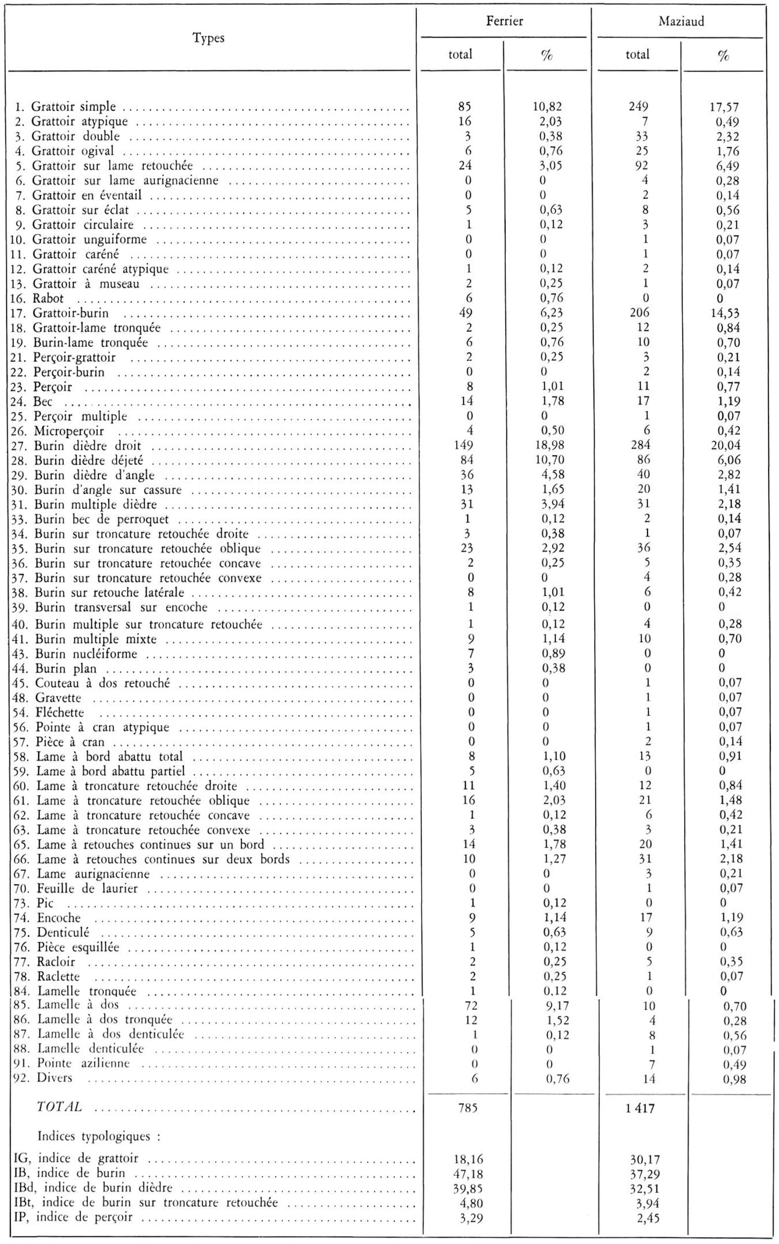
Table of lithics from Roc de Marcamps found by Ferrier and Maziaud.
Photo: Roussot et Ferrier (1970)
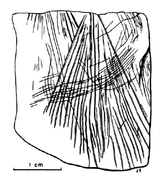
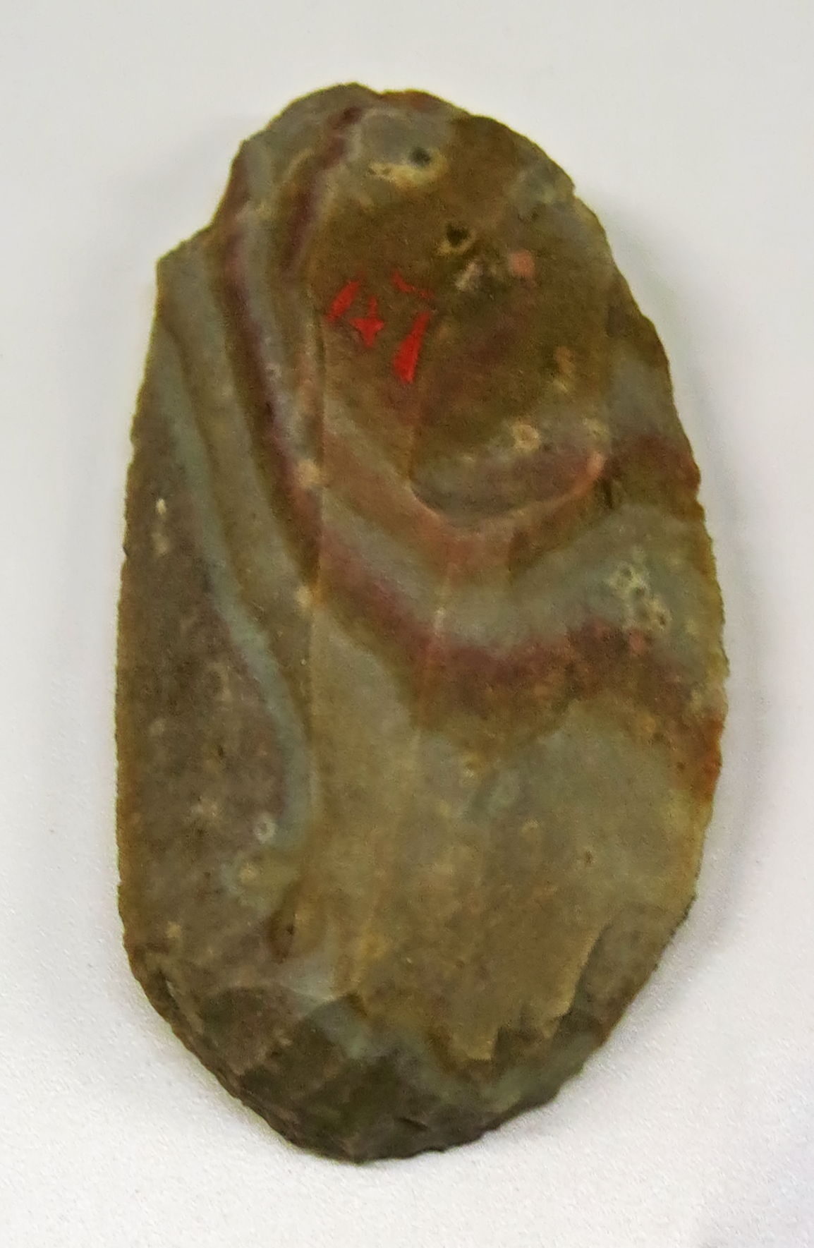
This engraved limestone pebble from Marcamps deserves special attention. It is a small flat pebble in limestone, substantially quadrangular shape, 30 mm on each side, and 5 mm thick. Two edges are natural; the other two correspond to old fractures that appear to be prior to engraving. One side (the back is blank) carries a 'decoration' of a finely etched drawing which is reproduced here.
One group, a little more strongly incised than the others starts from the top edge, diverging towards the lower edge without ever reaching it. It is intersected by a series of very fine parallel arcuate ridges which, starting at the left of the first group, goes to the right of the upper edge. Other lines descend diagonally from the upper left edge and partially overlap the two previous groups. As well, some scattered streaks include a deep oblique incision on the right edge.
Catalog: 70.19.468
Photo (left) and text: Roussot et Ferrier (1970)
Photo (right): Don Hitchcock 2015
Source: Original, display at Musée d'Aquitaine à Bordeaux

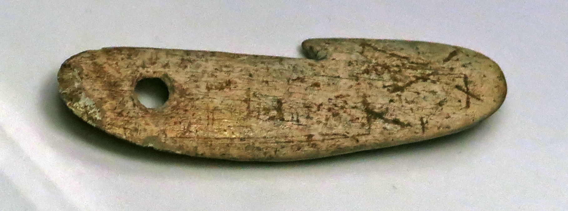
Propulseur (spear thrower) hooks from Roc de Marcamps. Made of reindeer antler, they are from the Maziaud collection.
The hook on the left is rounded at both ends. The top face, carefully polished, is curved. A bevel on which can be seen fine oblique striations thins the back towards the hook. This part has towards the base a circular perforation reminiscent of some types of Azilian harpoon hooks.
The hook on the right has the same characteristics, but is not perforated. In addition, the distal end is slightly pointed. (see photo of the original below - Don )
Photo and text: Roussot et Ferrier (1970)
Propulseur (spear thrower) hook from Roc de Marcamps. It is the original artefact depicted in the drawing above, at the left.
Photo: Don Hitchcock 2015
Catalog: 70.19.436
Source: Original, display at Musée d'Aquitaine à Bordeaux
Propulseur (spear thrower) hook from Roc de Marcamps. It is the original artefact depicted in the drawing above, at the right.
Photo: Don Hitchcock 2015
Catalog: 70.19.437
Source: Original, display at Musée d'Aquitaine à Bordeaux
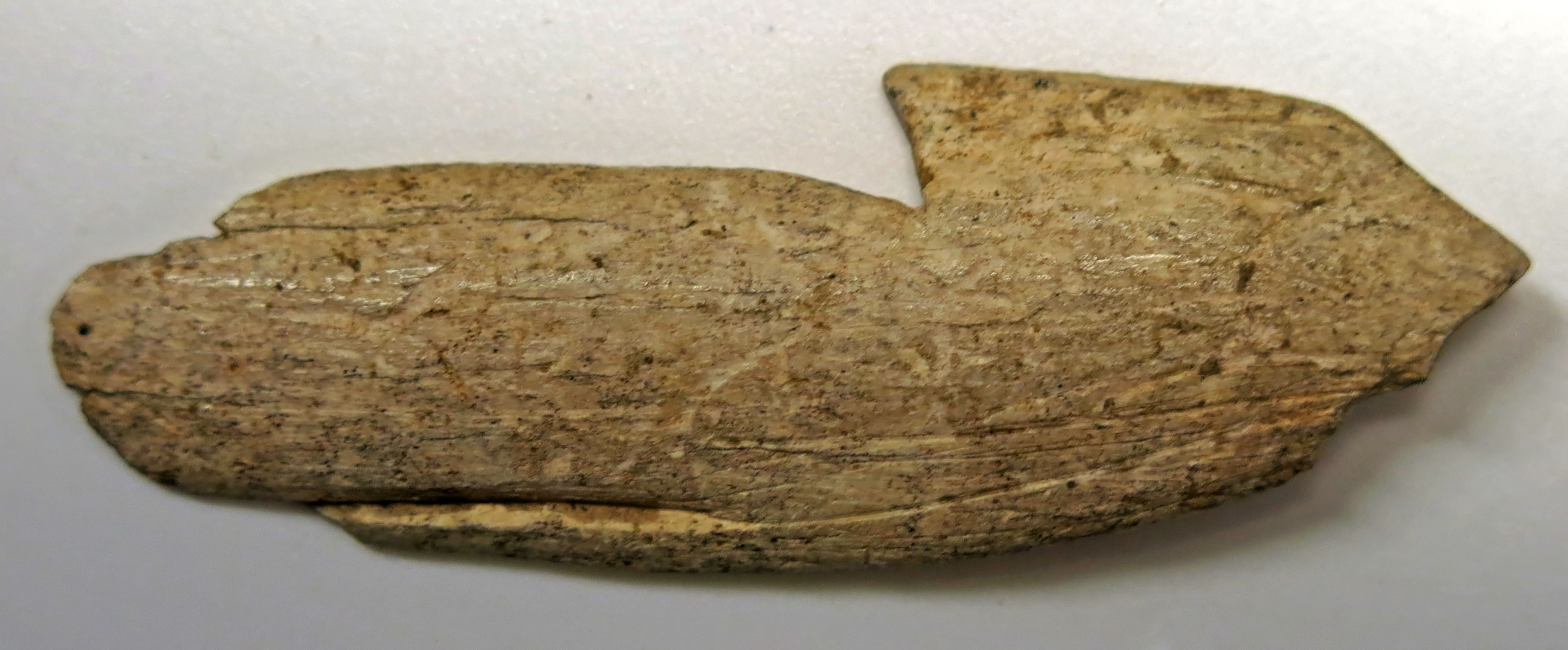
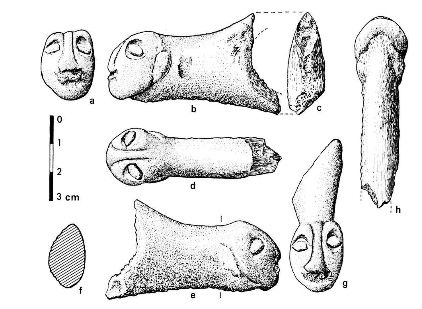
Anthropomorph sculpture on a perforated baton in reindeer antler, collected by J. Ferrier.
The figure is shaped on a flattened section of reindeer antler. Attention is immediately focused on a long straight nasal appendage flanked by two bulging eyes, highlighted by a wide and deep groove. There is no nasal bridge and the forehead is receding. The skull is slightly pointed at the top. Two arched furrows and some fine streaks indicate the mouth, set back from the nose. The neck is not clearly shown, it widens at a formerly broken elliptical perforation.
Photo and text: Roussot et Ferrier (1970)

Anthropomorph from Roc de Marcamps.
Certainly the resemblance of the sculpture with a human head is not obvious. However, it is difficult to find a term of comparison in the animal world. Among the birds, it evokes the form of one of the diurnal raptors, Falconiformes, when seen from the front, with a long beak, but in profile these raptors have beaks which are hooked at the tip. The head is more elongated in the occipital area.
Text: adapted from Roussot et Ferrier (1970)
Photo (left): http://visites.aquitaine.fr/roc-de-marcamps
Photo (right) Don Hitchcock 2015
Source: Original, Musée d'Aquitaine à Bordeaux
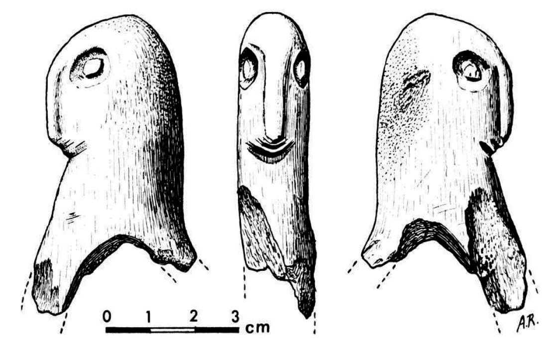
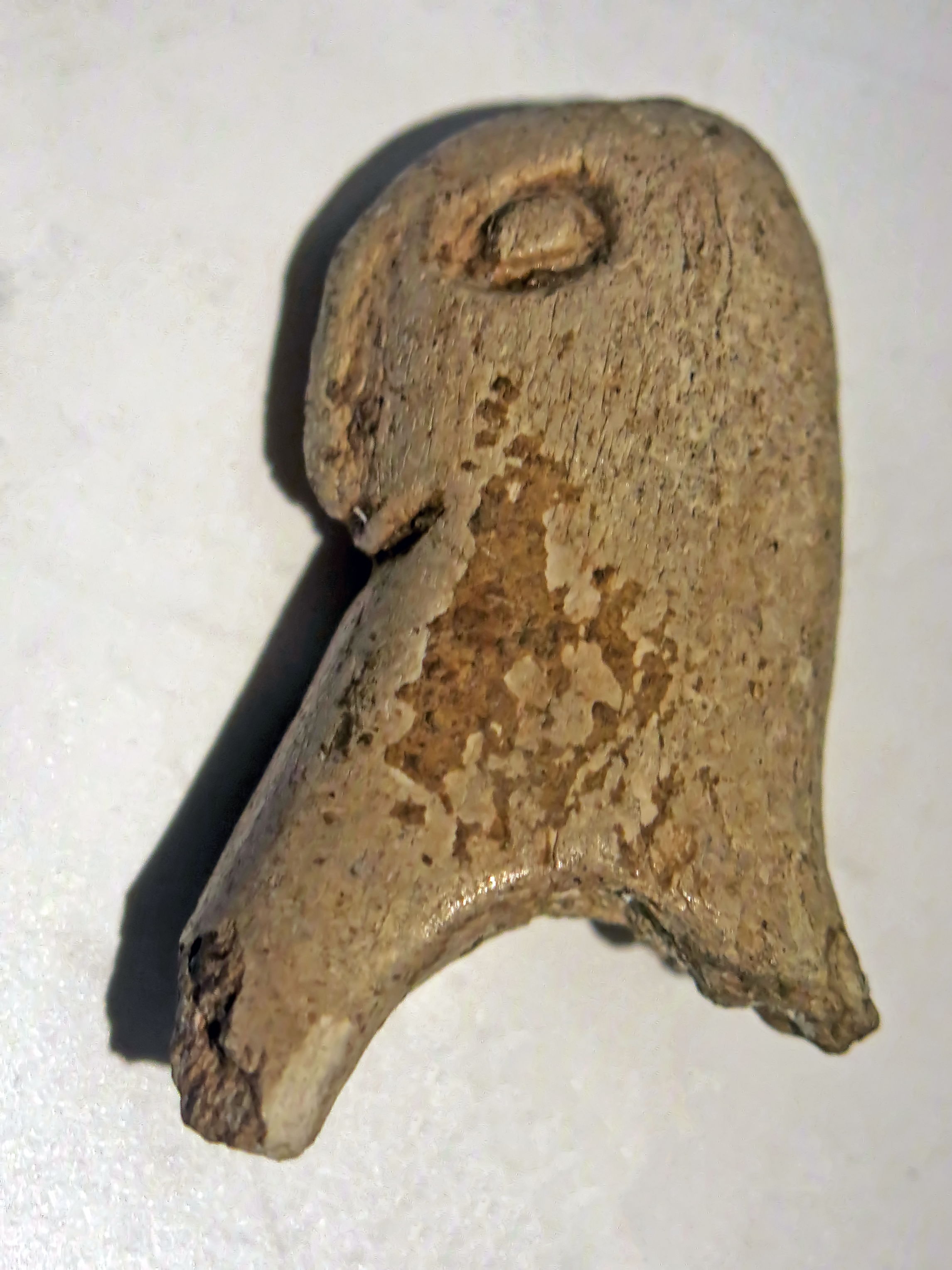
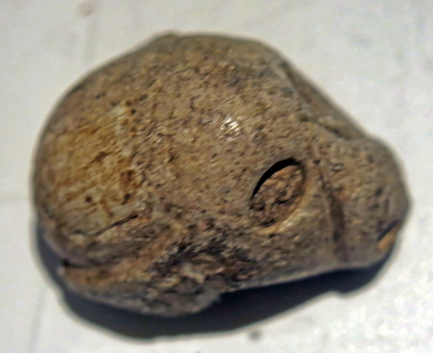
Anthropomorph sculpture of a head in reindeer antler, collected by G. Maziaud.
The second sculpture is no less enigmatic. It has a low skull, an elongated, almost receding forehead, a simian face with a strong flat nose; a slight bulge on the posterior part of the skull suggests a crown of hair fashionable amongst Benedictine monks ... Seen from the front the face shows a clear asymmetry of the nose and eyes. This caricature of simian appearance probably can not be compared to a cat as has been suggested elsewhere.
(see photo of the original below - Don )
Photo and text: Roussot et Ferrier (1970)
Anthropomorph sculpture of a head in reindeer antler, collected by G. Maziaud.
(I would be grateful for a link to a better quality image of this important piece - Don )
Photo: Don Hitchcock 2015
Source: Original, Musée d'Aquitaine à Bordeaux
Anthropomorph sculpture of a head in reindeer antler, collected by G. Maziaud.
Significantly more human is this head carved on the end of a bâton perforé. The facial features - nose, eyes, ears - are normally placed and are of suitable proportions. Again the skull is flat, with no clear indication of a forehead. Almond eyes, surrounded by a deep trough, are topped with a pronounced supra-orbital arc. The nose forms a slight relief bounded on each side by an etched groove.
(see photo of the original below - Don )
Photo and text: Roussot et Ferrier (1970)
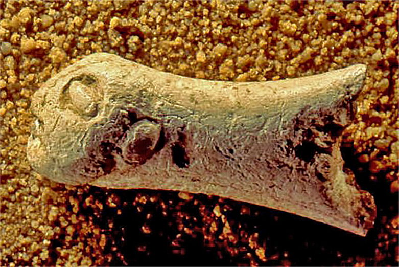
This elongated nose is unfinished at the base. Below the nose, the mouth region is less clear here because the surface has been damaged and shows the tubules of the interior of the reindeer antler used.
The chin is heavy, rounded, with a clear jaw line to the back of each side of the head to a relief that appears to be an ear. The left profile (b) is of a better quality than the right profile (e).
We have already said that several perforated batons from Roc de Marcamps are shaped like a phallus. When considering this sculpture by the lower face, one can not help but notice the same analogy. Is it due to chance, or has the artist wanted to project this ambiguity by sculpting a human face on the glans of a phallus? The important place given to sexuality, symbolic or real, in the art of Prehistory, authorises us to ask this question. Few reindeer antler sculptures comparable to these three sculptures from Marcamps.
Photo: http://ssaft.com/Blog/dotclear/index.php?tag/Phallus
Text: adapted from Roussot et Ferrier (1970)
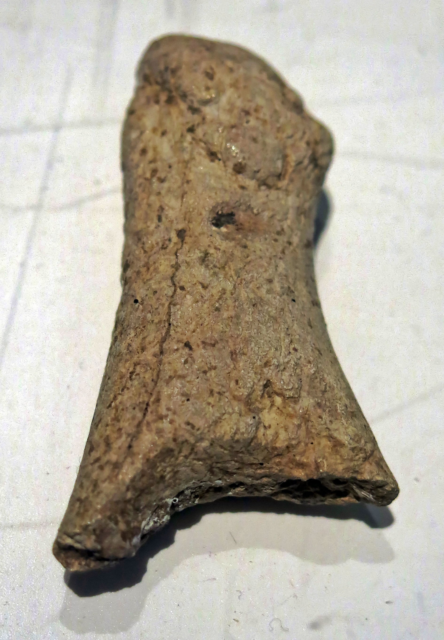
The hole of the pierced baton shows a great deal of either wear or erosion.
This piece has some elements of a phallus.
Photo: Don Hitchcock 2015
Source: Original, Musée d'Aquitaine à Bordeaux

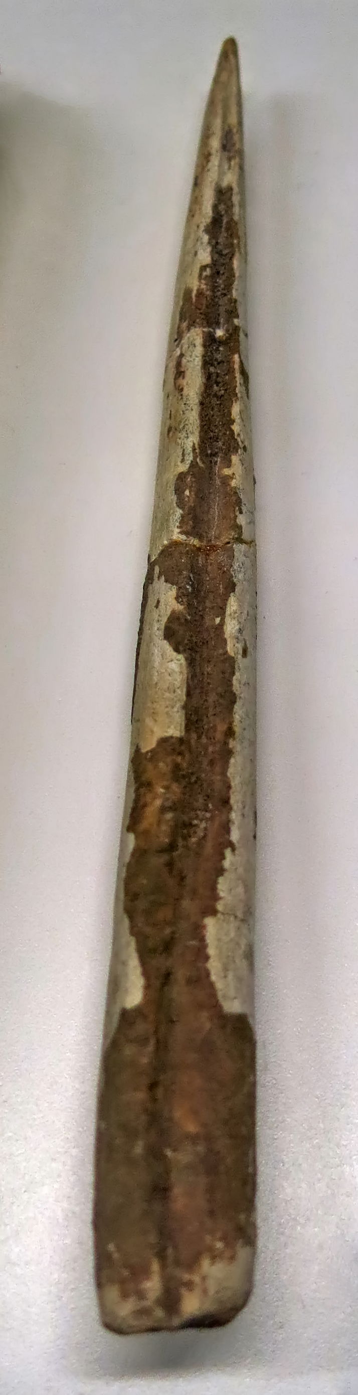
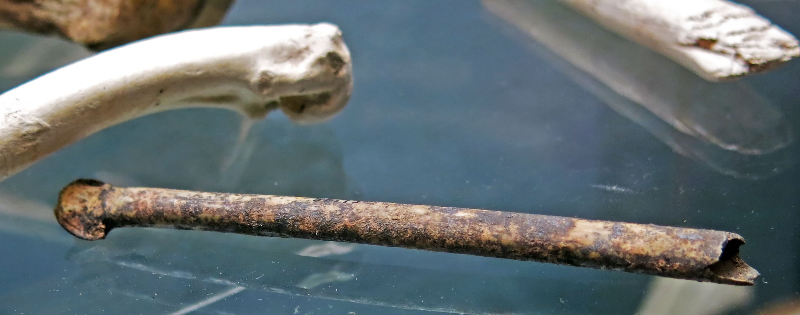
Spear point, or sagaie, from Grotte des Fées, of bone.
Catalog: 60.839.13
Photo: Don Hitchcock 2015
Source: Original, Musée d'Aquitaine à Bordeaux
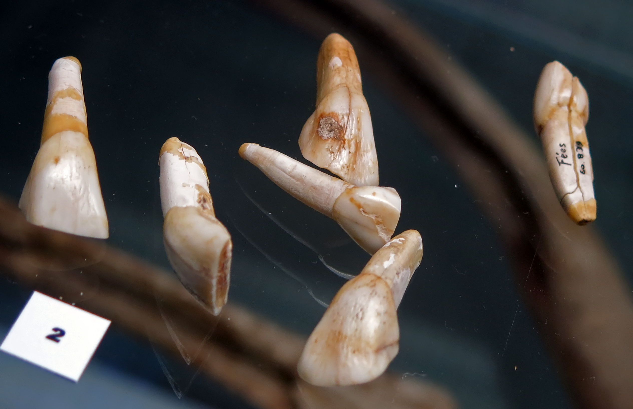
Bovine teeth from Grotte des Fées.
Catalog: 60.839.212
Photo: Don Hitchcock 2015
Source: Original, Musée d'Aquitaine à Bordeaux
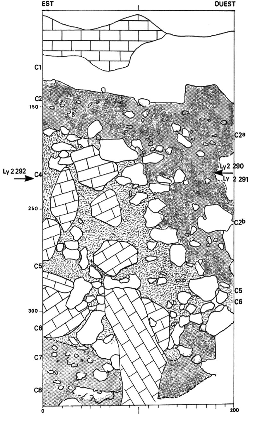
Roc de Marcamps, stratigraphy from the excavations of M. Lenoir, with indications of the samples taken for radiocarbon dating.
Note that this is a sondage, a test pit, in this case about 350 cm deep and 200 cm wide - Don )
C1: Bed of rubble.
C1b: Dark brown silt limestone granules and small boulders. Characterised by a high afforestation rate (52%) with dominant hazel and several thermophilic trees: oak, willow, elm, lime, ash. Probably early Holocene.
C1c: Sandy loam with much rock debris. Lowest afforestation rate (12-15%), pine and birch dominant. Compositae (daisies) and grasses are the main species In the NAP, but without Artemisia. Probably Dryas III.
C2a: Clayey silt with little rock debris. Afforestation rate slightly higher (25-27%): Scots pine and hazel dominate, along with birch and willow. Probably Bölling. Layer containing perhaps the Magdalenian.
C2b: probably the layer where the shuttles were found, dated to 14 910 ± 240 BP (Ly-2291). Yellow-brown clay loam rich in small boulders and limestone granules. Very low afforestation rate (11-14%) with pine dominant, and birch and willow rarer. The Compositae dominate in the NAP, indicating a steppe landscape. In fauna, saïga dominates, accompanied by bos / bison, horse and reindeer (more rare). Some remains of wolf, fox, deer, bear and rhinoceros.
C3: silty clay sediment with a date of 15 700 ± 450 BP (Ly-2681). Landscape typical of cold steppe even richer in Compositae than the overlying layer.
C4a and C4b: The same conditions apply for the formation of the layers C4a and C4b. There is always Magdalenian character archaeological material, but it is more rare.
C4c: scree in a clay matrix: 17 410 ± 310 BP (Ly-2292). Pollens typical of a mild climate improvement, probably the time period of Lascaux. Traces of archaeological material attributable to the Magdalenian.
C5: Scree of rocks of many different sizes, richer in trees (30%), especially pine, willow and hazel. Probably the Laugerie interstadial (Wurm 3-4).
C8: the deeper layers provided Aurignacian dated to 26 500 BP ± 1400 (Ly-2682).
Photo and text: Allain et al. (1985)
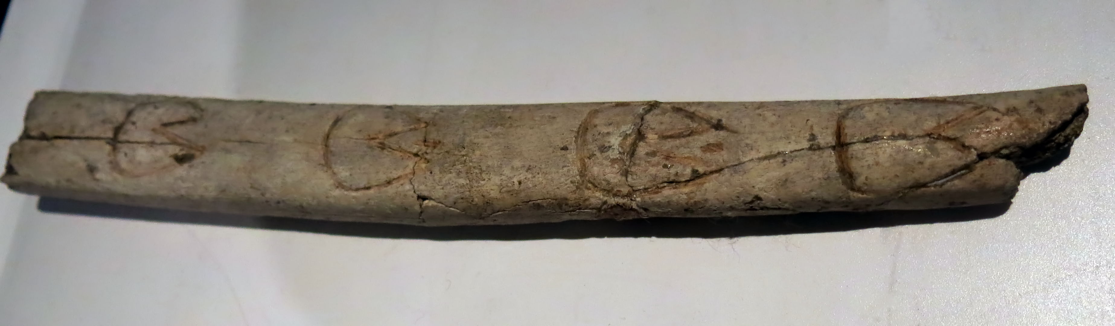
This is a bâton of reindeer antler with vulvas in line from Roc du Marcamps. It illustrates well the shape of the vulvas which the artists drew. In this example, the vulvas are rounded, not triangular, but they are all carefully engraved with a linear V shaped incision.
Photo: Don Hitchcock 2015
Catalog: 75.16.1
Source: Original, display at Musée d'Aquitaine à Bordeaux
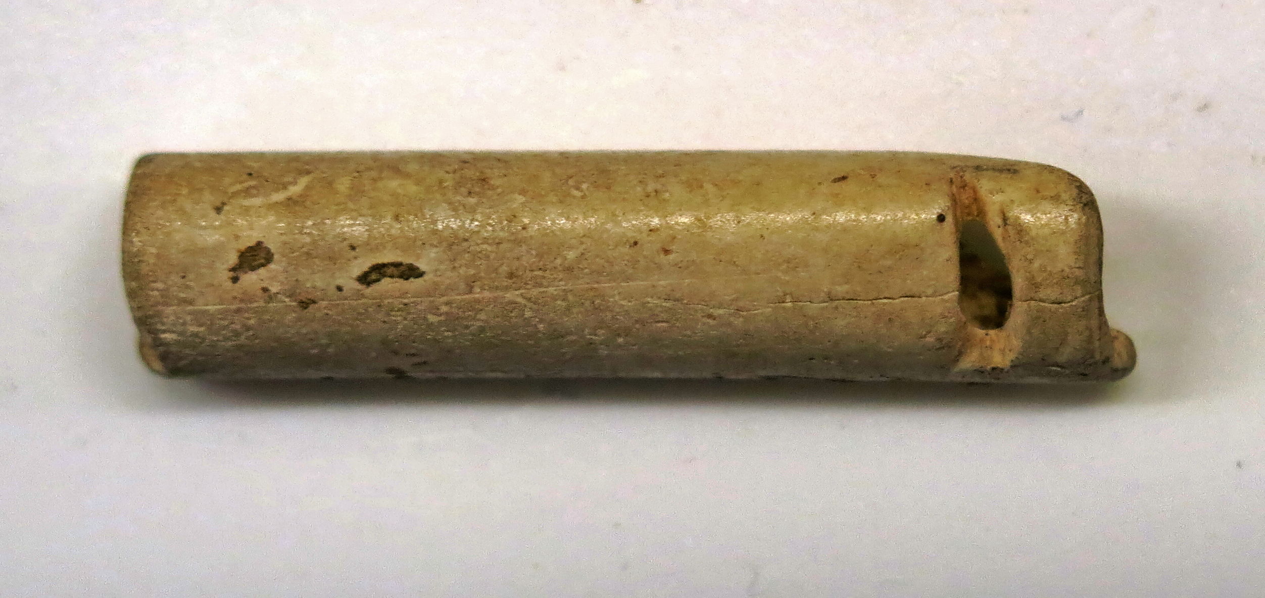
Whistle from Roc de Marcamps, apparently made from a bird bone.
Catalog: 70.19.465
Photo: Don Hitchcock 2015
Source: Original, Musée d'Aquitaine à Bordeaux
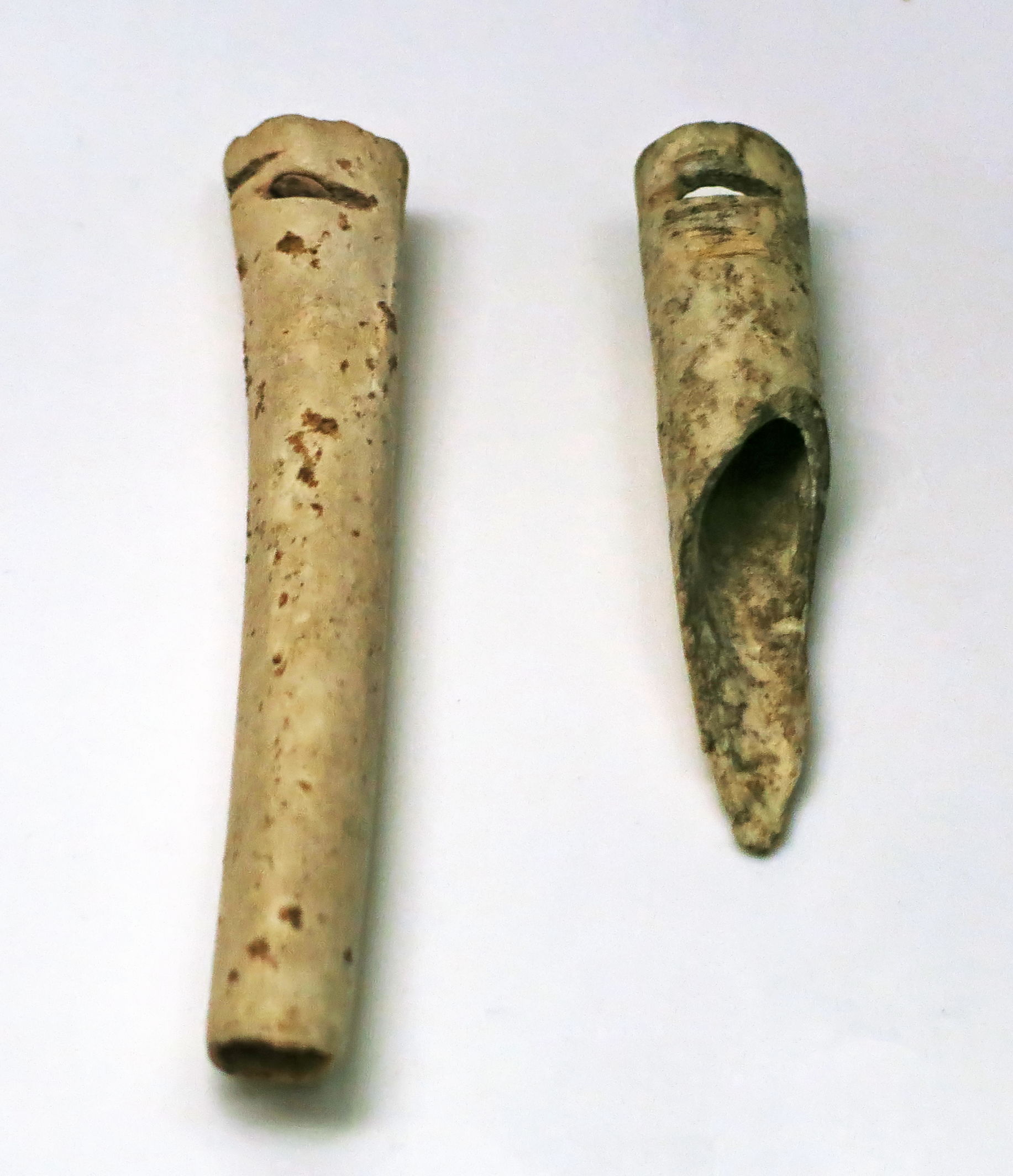
Magdalenian whistles from Roc de Marcamps, made of bird bones.
Catalog: 70.19.463, 70.19.464.
Photo: Don Hitchcock 2015
Source: Original, Musée d'Aquitaine à Bordeaux
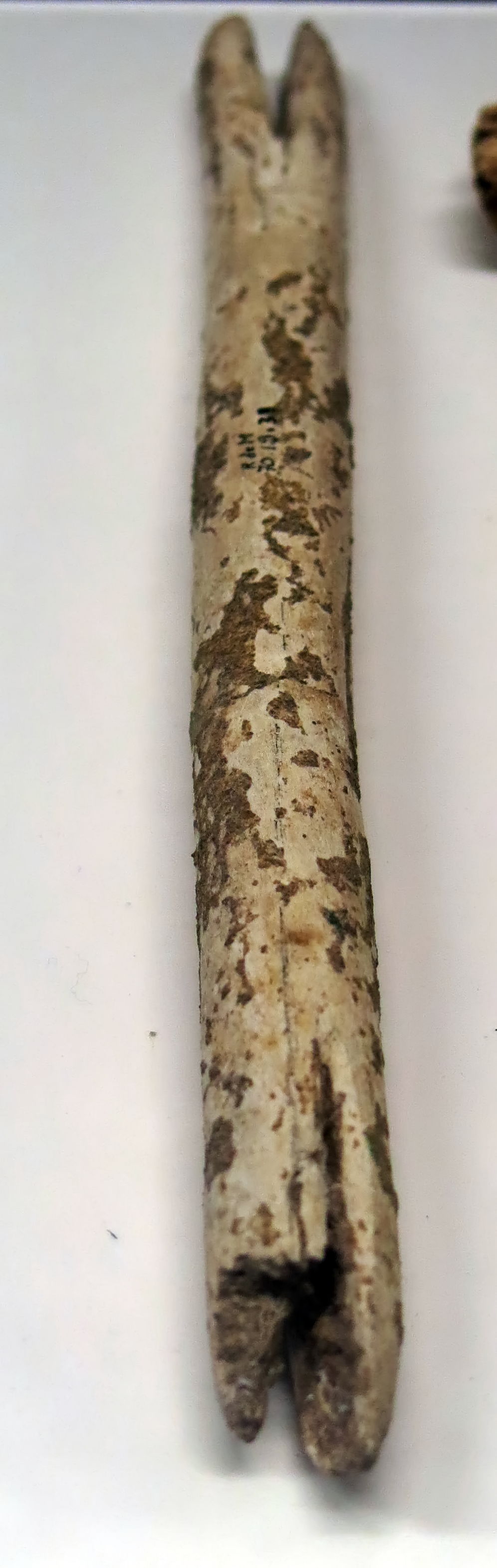
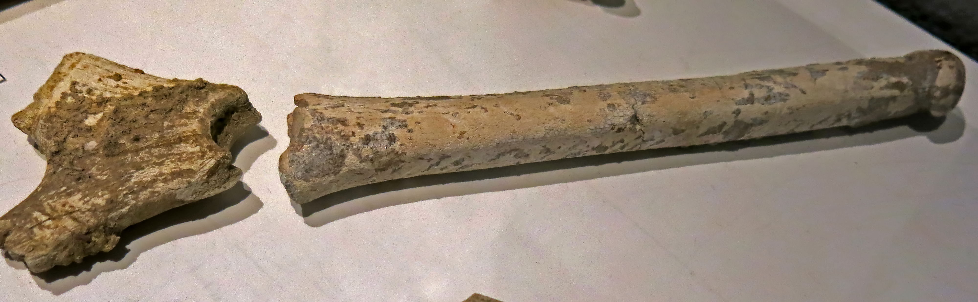
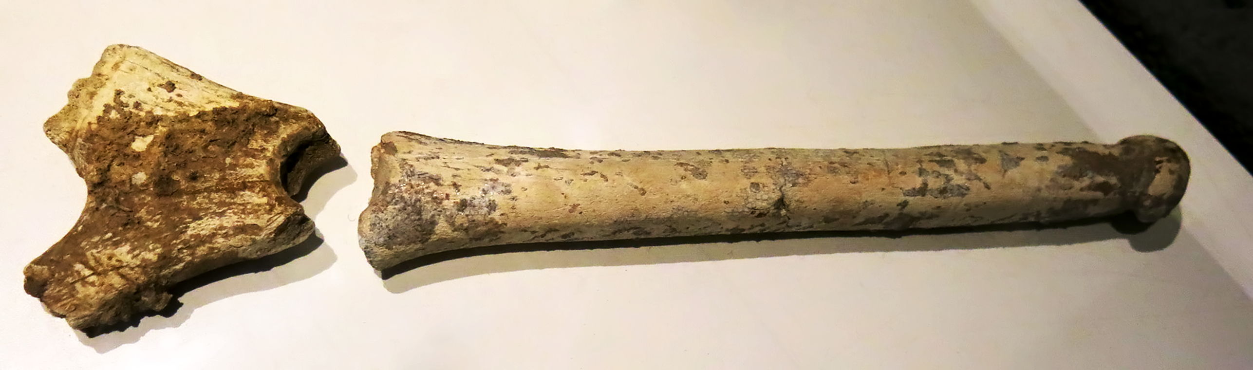
This is labelled as a shuttle from Roc de Marcamps. Although at first sight this appears to be clear evidence of weaving, the literature discounts that hypothesis, and the name was given because of its similarity to shuttles used for weaving. Instead, they are thought to be double ended handles for tools, with a flint blade in each of the slots.
Many similar shuttles were found at Laugerie Haute and Laugerie Basse, see Allain et al. (1985).
Catalog: 70.19.438
Photo: Don Hitchcock 2015
Source: Original, Musée d'Aquitaine à Bordeaux
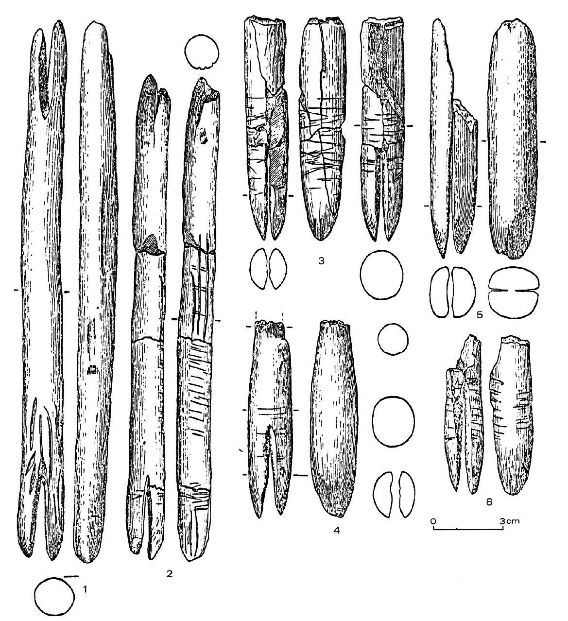
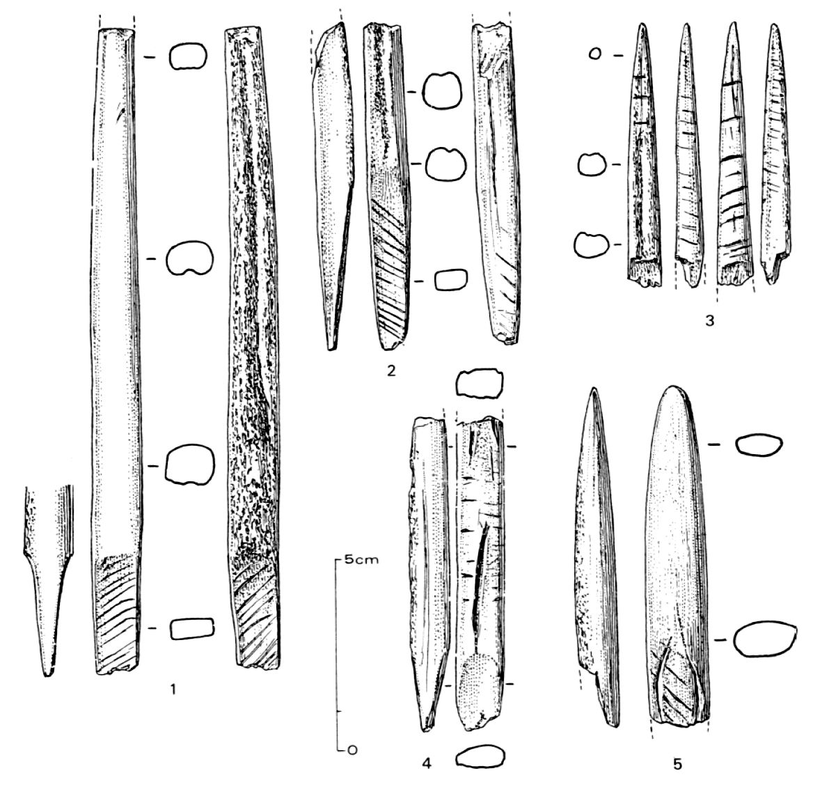
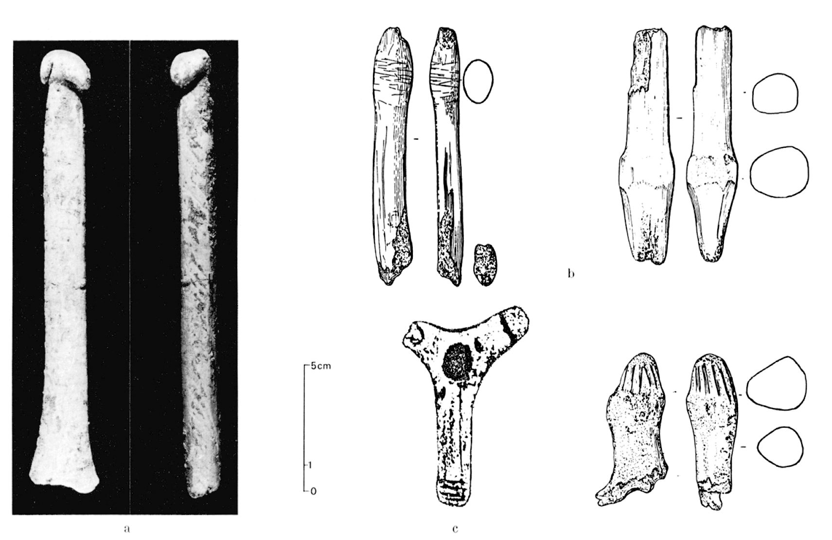
Shuttles from Roc de Marcamps.
Photo: Allain et al. (1985).
Sagaies (spear points) from Roc de Marcamps.
Photo: Allain et al. (1985).
Phallus from Roc-de-Marcamps, Prignac-et-Marcamps, Magdelanian.
Reindeer antler, length 180 mm, width 29 mm.
Photo: Don Hitchcock 2015
Catalog: 75.16.2
Source: Original, Musée d'Aquitaine à Bordeaux
The phallus is in the form of a spear straightener, or bâton percé.
Photo: Don Hitchcock 2015
Catalog: 75.16.2
Source: Original, Musée d'Aquitaine à Bordeaux
Phalliform sculptures from Roc de Marcamps.
The photograph on the left is of the phallus shown in the images immediately above.
Photo: Allain et al. (1985).
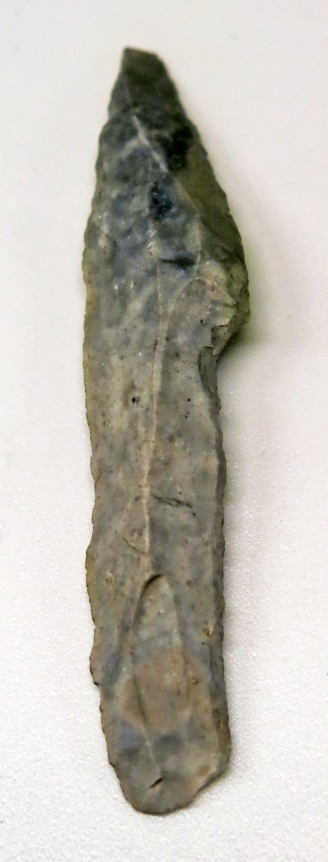
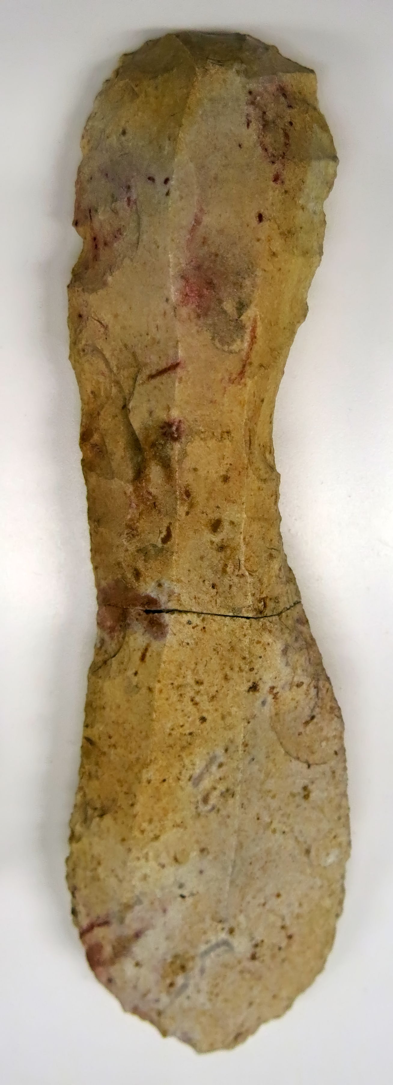
Pointe à cran, shouldered point, from Roc de Marcamps.
Magdalenian flint point.
Photo: Don Hitchcock 2015
Catalog: 70.19.421
Source: Original, Musée d'Aquitaine à Bordeaux
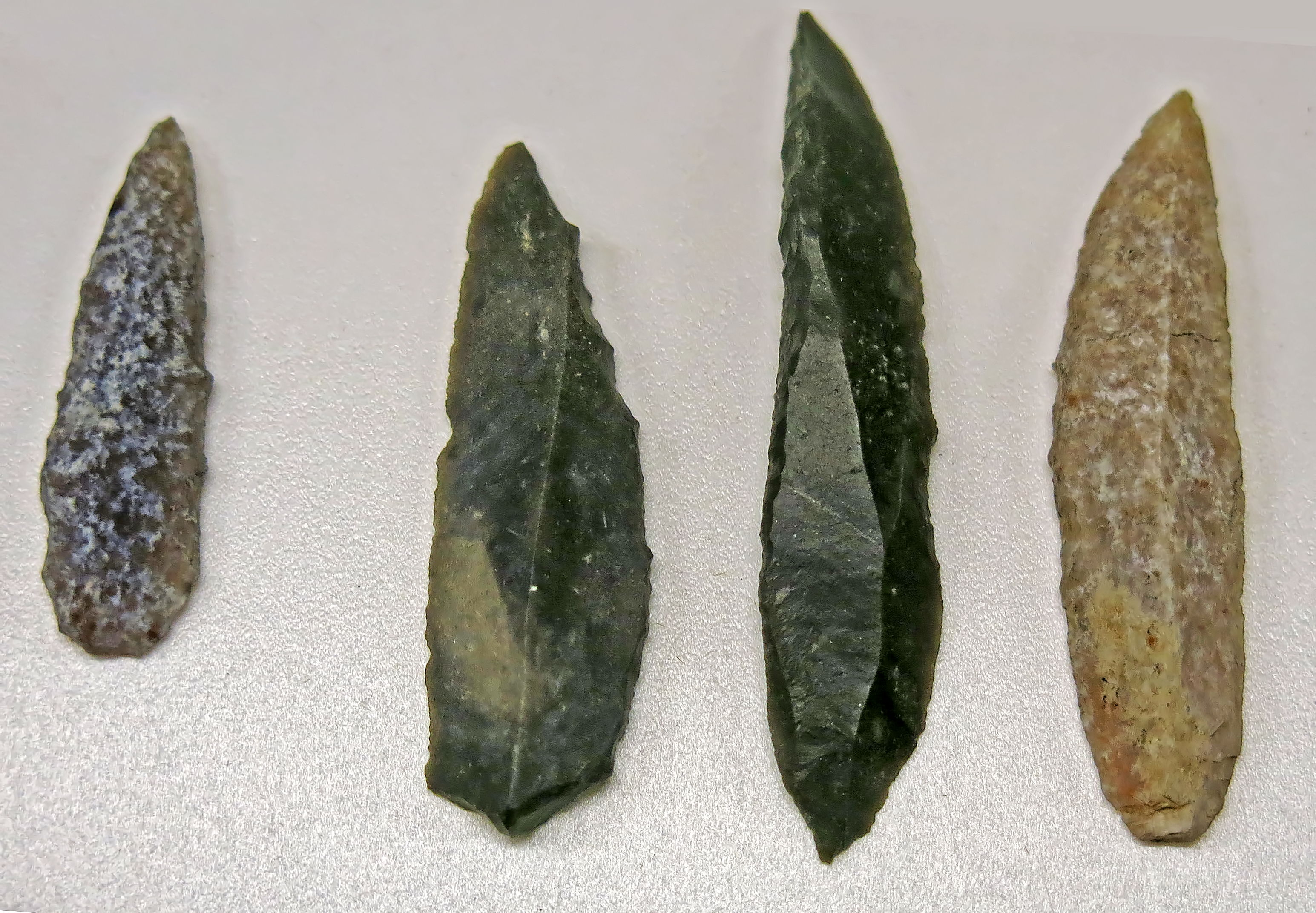
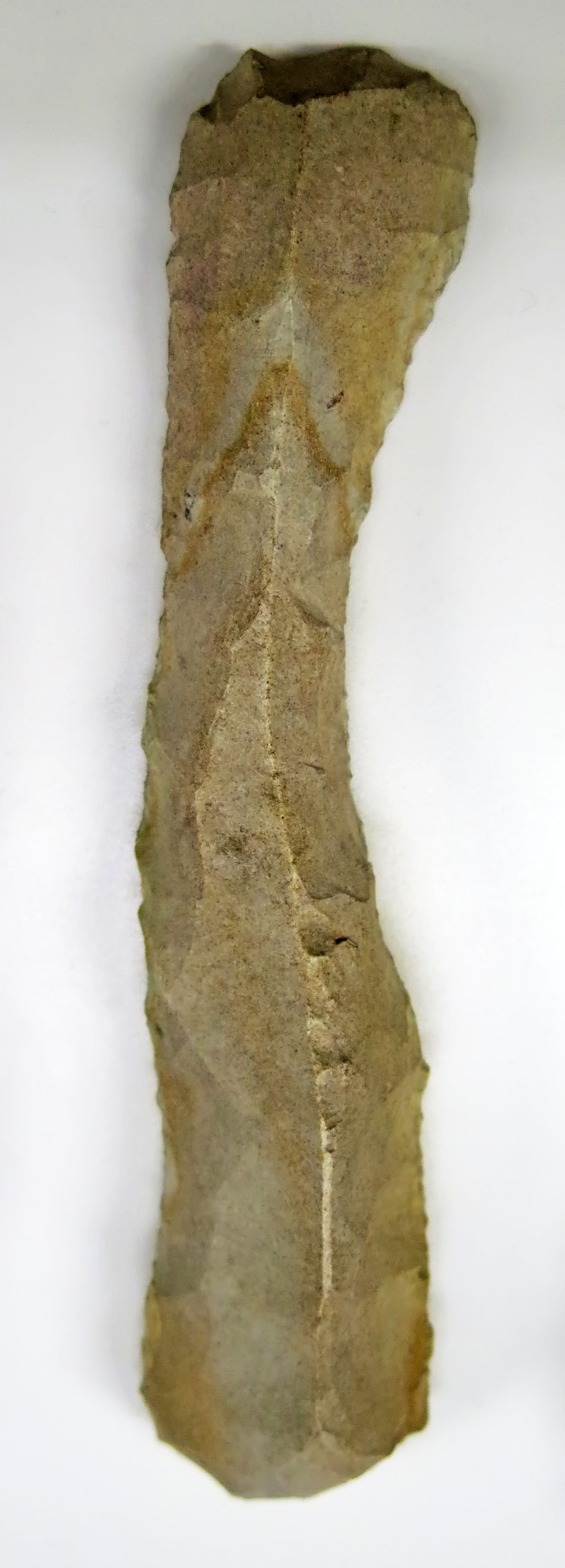
Retouched blades from Roc de Marcamps.
Photo: Don Hitchcock 2015
Catalog: 70.19.429 to 70.19.431
Source: Original, Musée d'Aquitaine à Bordeaux
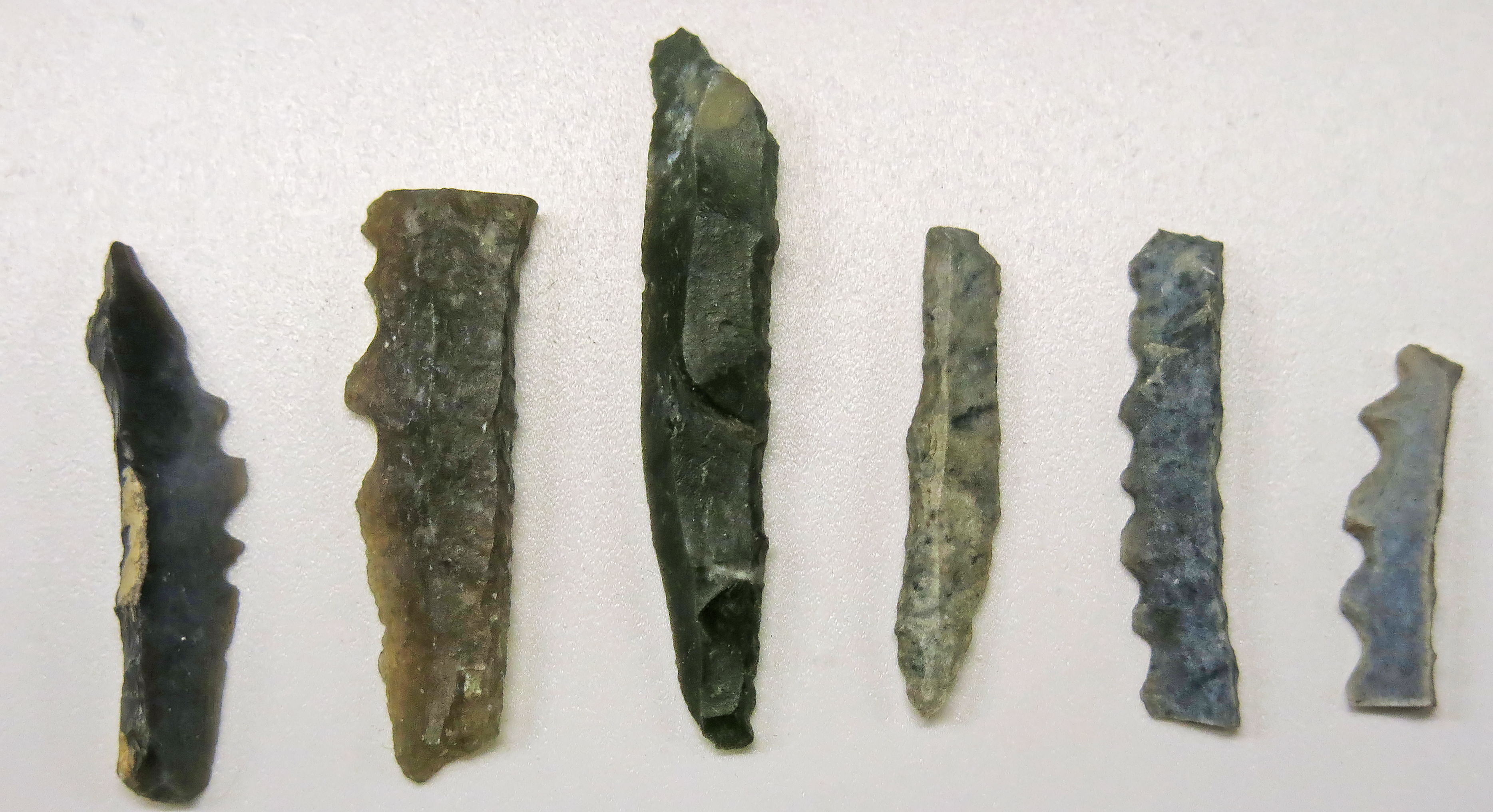
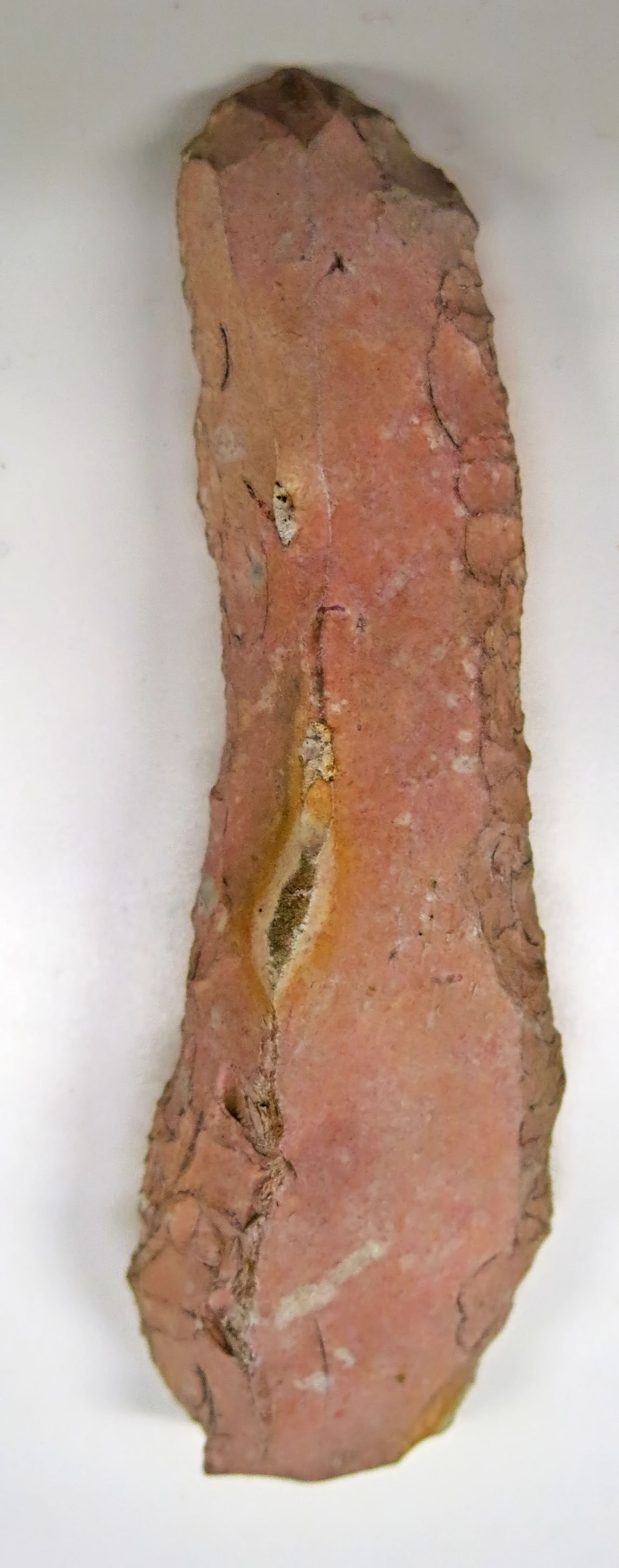
Backed, retouched blades from Roc de Marcamps.
Photo: Don Hitchcock 2015
Catalog: 70.19.422 to 70.19.427
Source: Original, Musée d'Aquitaine à Bordeaux
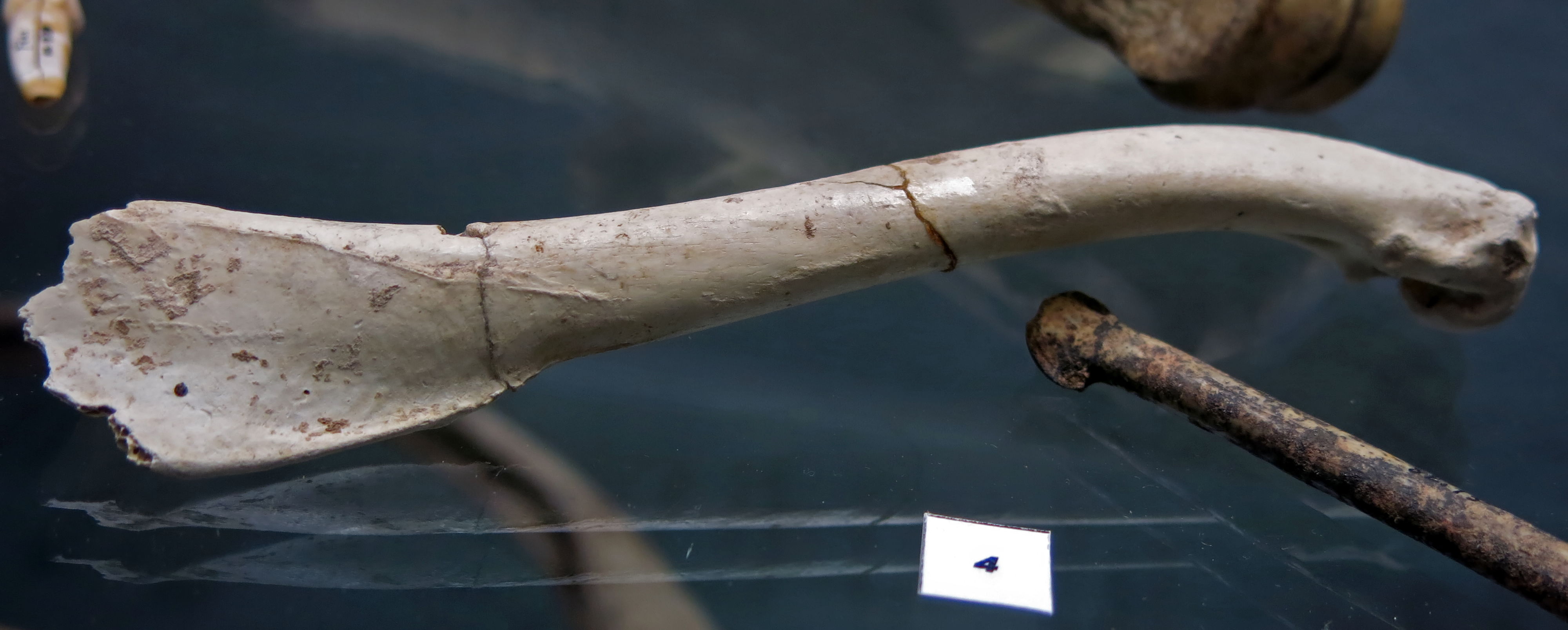
Humerus of a snowy owl (above) and ulna of a Royal Eagle (below) from Roc de Marcamps and Fontarnaud, Lugasson.
Photo: Don Hitchcock 2015
Catalog: 70.19 and 82.15
Source: Original, Musée d'Aquitaine à Bordeaux
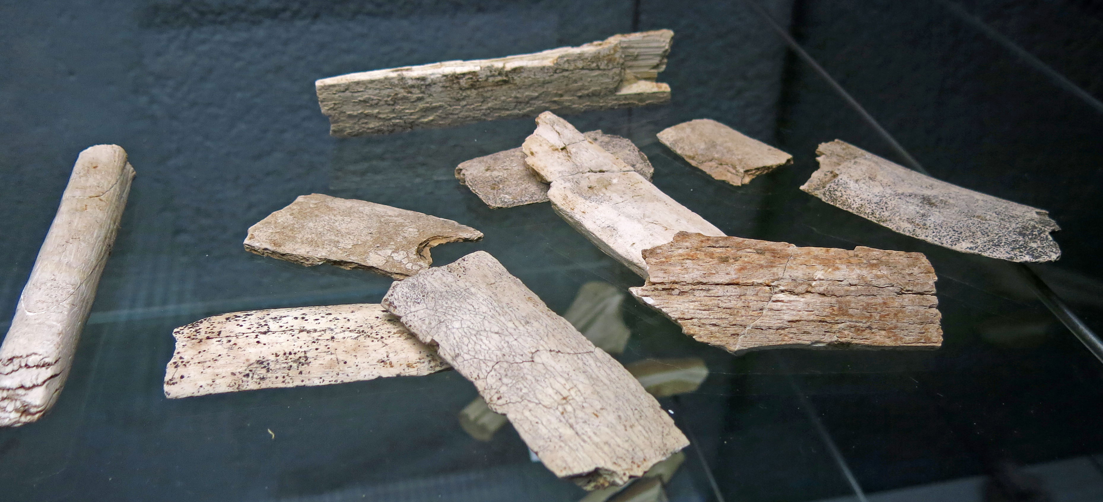
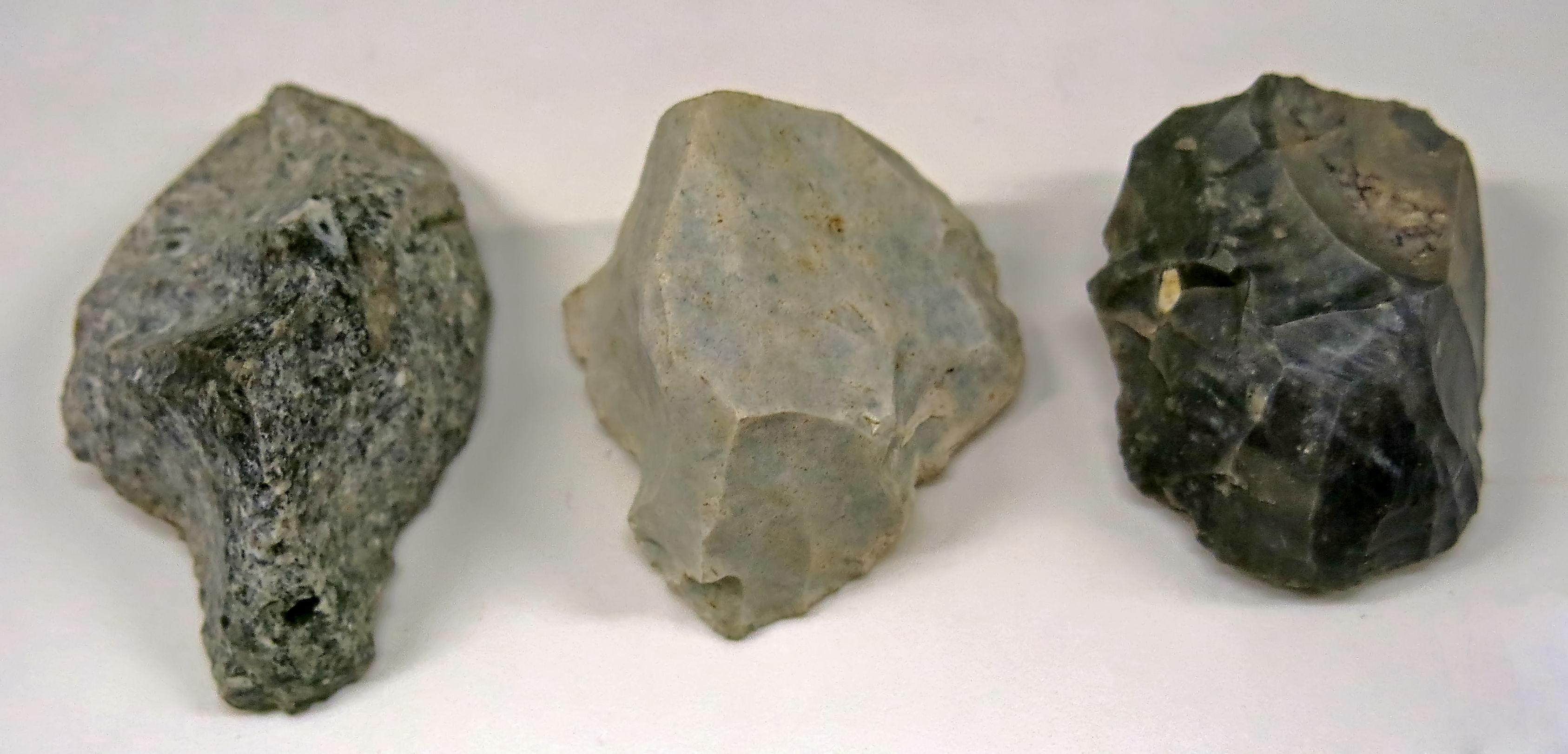
Pieces of mammoth ivory from Roc de Marcamps.
Photo: Don Hitchcock 2015
Source: Original, Musée d'Aquitaine à Bordeaux
La Grotte de Jolias
Now destroyed, this grotte was discovered by Daleau in 1873. The lithics are shown below. The lithic industry kept in the Museum of Aquitaine collection comes from several points, and probably is not homogeneous. It is however characterised by a clear Aurignacian component with thick scrapers, blades with Aurignacian retouching, sometimes waisted, (Lenoir, 1983 ).
Text above adapted from Lenoir (2000)
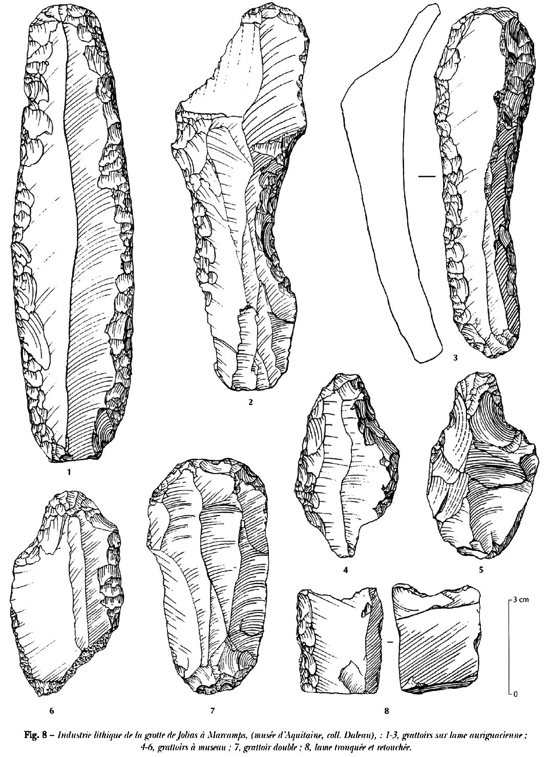
Lithic industry of la grotte de Jolias at Marcamps, musée d'Aquitaine, Daleau collection.
1 - 3 Grattoirs (scrapers) on Aurignacian blades.
4 - 6 Grattoirs à museau (nosed or muzzle shaped scrapers).
7 Double scraper.
8 Truncated and retouched blade.
Photo and text: Lenoir (2000)
Lenoir, M., 1983: Le Paléolithique des basses vallées de la Dordogne et de la Garonne, thèse de Doctorat d'État es Sciences, univ. de Bordeaux I, 2 vol. 702 p.
Lenoir M., 1983 : Le Paléolithique des basses vallées de la Dordogne et de la Garonne, thèse de Doctorat d'État es Sciences, univ. de Bordeaux I, 2 vol. 702 p.
On the 11th April 1873, during a botanical field trip along the Moron valley, along with other Linnaeans, Linder, Broclion, and Motelay, Daleau discovered a new palaeolithic site, unpublished, at grotte Jolias, Marcamps. Gassies was charged with presenting the objects collected in the field, and on May 14th, began a thorough search, conducted with impeccable method by Gassies and Daleau. The lithics and fauna were carefully collected and studied in full. It was a Magdalenian site. A report was printed in 1874 in the third volume of the Journal of Anthropology, with an excellent coupe (cross section diagram) and three beautiful lithographed plates.
It was the first time that a Palaeolithic site had been completely studied and published. Although Gassies wrote the report, he insisted that, in fairness, the name of his young friend should figure next to his in the authorship. The vocation of Daleau as prehistorian had been publicly affirmed.
Burin, Grotte de Jolias, Prignac-et-Marcamps
Photo: Don Hitchcock 2015
Catalog: 60.913.8
Source: Original, Musée d'Aquitaine à Bordeaux
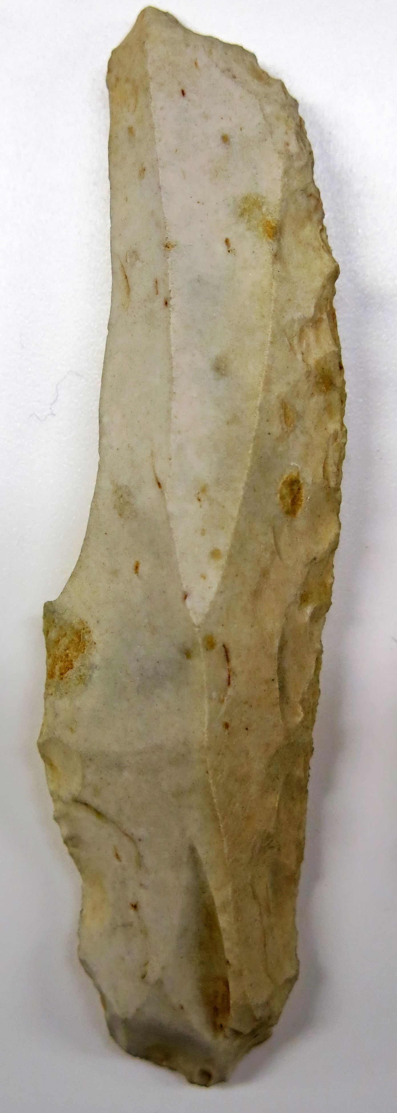
These three tools are labelled as being Aurignacian blades, and coming from Grotte de Jolias, Prignac-et-Marcamps and Laussel, Marquay.
Judging from the catalog numbers, it is possible that the left hand tool is from Grotte de Jolias, and the other two are from Laussel.
They are large thick Aurignacian blades, retouched bilaterally and of the type known as waisted blades, or in French, 'strangled' blades, a very appropriate term.
Photo: Don Hitchcock 2015
Catalog: 60.913.3, 61.3.80, 61.3.91
Source: Original, Musée d'Aquitaine à Bordeaux
Grattoir from Grotte de Jolias.
Photo: Don Hitchcock 2015
Catalog: 60.931.1
Source: Original, Musée d'Aquitaine à Bordeaux
Grattoirs à museau, nosed shaped scrapers from Grotte de Jolias.
Photo: Don Hitchcock 2015
Catalog: 60.913.5
Source: Original, Musée d'Aquitaine à Bordeaux
References
- Allain, J. et al, 1985: Le Magdalénien à navettes , Gallia préhistoire, 1985 Volume 28 Issue 1 pp. 37-124
- Daleau, F., 1874: Grotte des Fées (Age du Renne), située au Roc, commune de Marcamps, canton de Bourg (Gironde), Société archéologique de Bordeaux, Volume 1, Bordeaux, France, 1874 pp. 110-119, two plates.
- Lacorre, F., 1938: La grotte des Fées, à Marcamps (Gironde) ou Roc de Marcamps (fouilles du groupe des préhistoriens de la Société Linnéenne), Procès-verbaux de la Société Linnêenne de Bordeaux, t. 90, 1938, pp. 35-51, 1 fig.
- Lenoir, M., 1983: Le Paléolithique des basses vallées de la Dordogne et de la Garonne, thèse de Doctorat d'État es Sciences, univ. de Bordeaux I, 2 vol. 702 p.
- Lenoir, M., 2000: La Préhistoire ancienne en Gironde : apport des recherches récentes, Gallia préhistoire, Année 2000 Volume 42 Numéro 1 pp. 57-84
- Malvesin-Fabre, G., 1945: François Daleau, Préhistorien, Son Oeuvre Dans le Domaine du Paléolithique, Actes de la Société Linnéenne de Bordeaux, Tome XCIII 1943-1946, Bordeaux Imprimerie E. Drouillard.
- Roussot, A., Ferrier J., 1970: Le Roc de Marcamps (Gironde). Quelques nouvelles observations, Bulletin de la Société préhistorique française, Études et travaux. 1970, tome 67, N. 1. pp. 293-303.
Back to Don's Maps
Back to Archaeological Sites