Back to Don's Maps
 Back to Archaeological Sites
 Back to Egypt Index Page
The Battle of Megiddo
Eighteenth Dynasty: 1 550 BC - 1 292 BC
King Thutmose III - The Battle of Megiddo
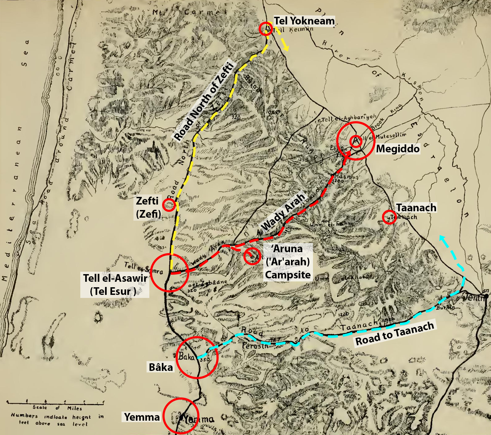
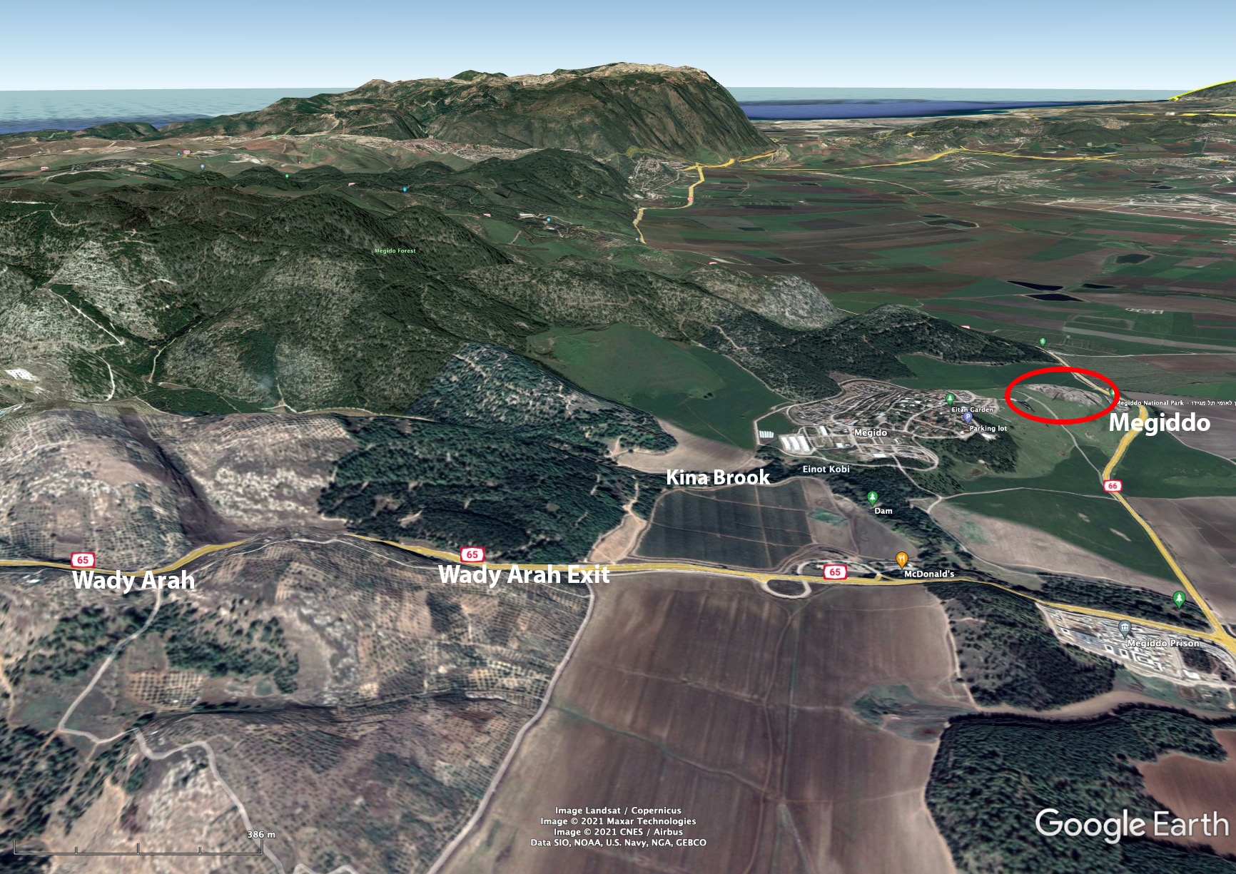
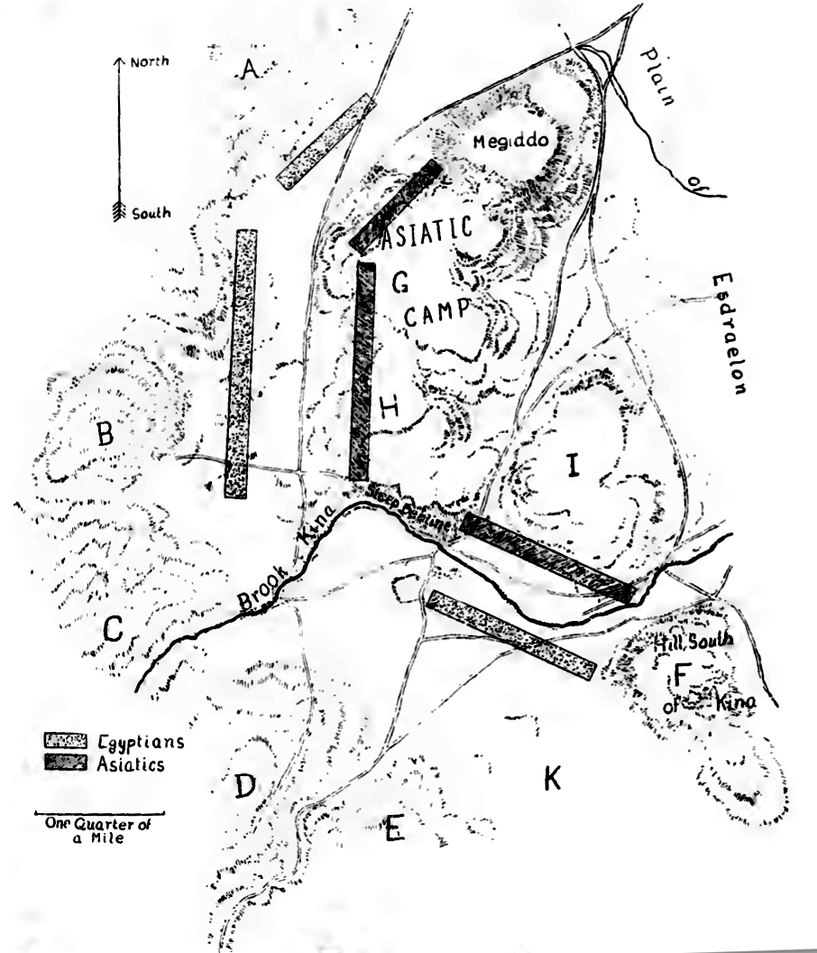
Above: The three roads described in the Annals of Thutmose III in relation to the battle of Megiddo in the 15th century BC (as reconstructed by Nelson). Thutmose took the middle road, the Wady Arah, which was the most difficult but led him very close to Megiddo.Base map and text: adapted from Nelson (1913)
Permission: Public Domain
Modifications to the base map: Don Hitchcock 2021
The Battle of Megiddo (fought in the 15th century BC) was fought between Egyptian forces under the command of Pharaoh Thutmose III and a large rebellious coalition of Canaanite vassal states led by the king of Kadesh. It is the first battle to have been recorded in what is accepted as relatively reliable detail. Megiddo is also the first recorded use of the composite bow and the first body count. All details of the battle come from Egyptian sources — primarily the hieroglyphic writings on the Hall of Annals in the Temple of Amun-Re at Karnak, Thebes (now Luxor), by the military scribe Tjaneni.
The ancient Egyptian account gives the date of the battle as the 21st day of the first month of the third season, of Year 23 of the reign of Thutmose III. It has been claimed that this was April 16, 1457 BC, according to the Middle Chronology, although other publications place the battle in 1482 BC or 1479 BC. The Egyptians routed the Canaanite forces, which fled to safety in the city of Megiddo. Their action resulted in the lengthy Siege of Megiddo.
Text above: adapted from Wikipedia
Accepted spelling of place names has changed over the years, and between sources, not least since they were originally in local ancient dialects, and there are often alternate spellings of modern Arabic or Hebrew place names in any case.
| Place Names | |||
|---|---|---|---|
| Nelson's Names | Other Names | Modern Names | Comments |
| 'Aruna | 'Ar'Arah | Ar'ara | 'Ar'Arah and Ar'ara are both now in common usage. 'Aruna was the form used by Thutmose III. |
| 'Aruna Road | Wady/Wadi Arah | Wadi Ara | 'Aruna Road was the form used by Thutmose III. |
| Tell Kaimûn | Tell Kaimun | Tel Yokneam (near Yokne'am Illit) | Qamun was a Palestinian village, the site of the Canaanite royal city of Jokneam. |
| Megiddo | Armageddon | Tel Megiddo | Armageddon is the Greek form, used in the bible. The Hebrew is הַר מְגִדּוֹ , Har Məgīddō. |
| Zefti | Djefti | Tel Zefi | Close to the hill of Giv'at Ẕefi. |
| Taanach | Ta'nakh | Tel Taanach | Ti'inik is a village close to the ancient town of Taanach. |
| Tell el-Asâwir | Tel Esur | Tell el-Asawir | During the Early Bronze Age, around 3 000 BC, a massive fortified proto-city with an estimated population of 5 000 to 6 000 inhabitants existed there. |
| Plain of Esdraelon | Valley of Megiddo | Jezreel Valley | The Jezreel Valley takes its name from the ancient city of Jezreel. |
| Kina Brook | Nahal Keini | ||
The following account of the Battle of Megiddo is based primarily on the 1913 doctoral thesis of Harold Nelson. It is a tour de force, made by someone who not only translated the hieroglyphic writings on the Hall of Annals in the Temple of Amun-Re at Karnak, Thebes (now Luxor), by the military scribe Tjaneni, but also walked and rode the entire length of the pass traversed by King Thutmose III in 1479 BC. He then matched the literal translation to 'ground truth', and made many important conclusions about the crossing of the ridge and the subsequent battle and siege.
The doctoral thesis of necessity jumps around a bit with regard to the timeline. I have tried to make the account into a coherent logical sequence as much as possible, while still giving important background information at appropriate places in the story where necessary. The original map, photographs, and the text of Nelson's thesis may be found at:
_________________
Background to the battle
When Thutmose III at last became sole ruler of Egypt after the death of his mother, Queen Hatshepsut, about 1 480 BC, he found himself confronted with a dangerous situation in his Asiatic provinces. The remnants of the Hyksos power, driven from Egypt a hundred years earlier by Ahmose I, and since brought into subjection to Egypt by Amenhotep I and Thutmose I, had taken advantage of the military inactivity of Hatshepsut's supremacy to combine as allies for a last struggle with the expanding power of Egypt. The centre of the movement seems to have been the King of Kadesh on the Orontes. Under his leadership the dynasts of Syria-Palestine united and their combined forces advanced southward to the Plain of Esdraelon to meet the advance of Thutmose III who was bent on bringing the rebellious states again under Egyptian control.
_________________
Megiddo - a strategic and commercially important fortress
At about the time of Thutmose III's campaign Megiddo was a strongly fortified place. Its defences consisted of a massive brick wall enclosing an area roughly oval in shape, some three hundred and fifteen metres long by two hundred and thirty meters wide. The wall, supported by buttresses at intervals, was about ten meters high and six metres thick, protected especially on the south and west against the driving of the winter rains by a projecting glacis.
In the early world, after trade between Egypt and the north had taken extensively to the land route, such cities undoubtedly collected heavy tolls from the passing caravans of merchants, much as did the feudal barons of the Middle Ages.
Any Egyptian campaign that aimed at gaining the Plain of Megiddo fell naturally into three movements: first, the advance to Gaza; second, the advance along the Philistine Plain; and third, the crossing of the Carmel Ridge. The rebels had inexplicably allowed Thutmose III to complete the first two movements unopposed, but they had made no effort to effectively defend the southern passes across the Carmel ridge at their entrances, nor along their lengths.
The rebels had left large infantry detachments guarding the exits of two more likely paths, and all but ignored the middle path. Now the Egyptian army had a clear path to Megiddo, and large parts of the rebel army were far away to the north and south.
_________________
Getting to the jumping-off point, Yemma
In the 22nd year of his reign, on the 25th day of the 8th month (April 19th, 1479 B.C.), Thutmose marched out of Egypt from the frontier fortress of Tjaru on his eastern border and lead his army towards Palestine to crush this rebellion.
Just how large his forces were it is impossible to say, though we may be certain that they comprised not more than 15 000 to 20 000 men, while 10 000 would probably not be underestimating their numbers.
The Asiatics certainly did not outnumber the Egyptians, and we may therefore place the contending forces at between 10 000 and 15 000 men each. Of these a portion was chariotry and the remainder infantry, armed for the most part with bows and spears. The sword was as yet almost, if not entirely, unknown in oriental warfare, probably not coming into use in the East till the introduction of Sherden mercenaries, who first appear under Amenhotep III. Each chariot held two men, the driver and an archer. The Hittites later were accustomed to use three men to a chariot, but we have no evidence that the Asiatics at this time used more than two men. The effectiveness of the chariot depended on the skill of the archer and on the demoralisation wrought among the enemy by the charge of the chariots into their ranks.
On the 4th day of the 9th month (April 28th), Thutmose was in Gaza,the first important place he met in Palestine. He left Gaza on the 5th day. When he reached Yemma on day 16, he seems to have come into touch with the enemy for the first time.
This is close to the meeting place of three roads that lead across the ridge to the Plain of Esdraelon, also called the Valley of Jezreel and the Valley of Megiddo.
Map of significant places in the Battle of Megiddo.
Source: https://www.navy.gov.au/sites/default/files/documents/Semaphore_2006_16.pdf
_________________
The choice of three roads
Any army approaching Syria from the south along the coast road encounters just beyond Yemma the first natural barrier to its advance. The ridge of hills, shooting off from the highlands of Ephraim, running from southeast to northwest and terminating at the seaward end in Mt. Carmel, cuts through the coastal plain and offers a natural bulwark of defence to southern Syria.
The Ridge, stretching for eighteen or nineteen miles, runs along the southern edge of the Valley of Megiddo. It is crossed in two places by roads which apparently have, since the beginning of history, served as highways of commerce for the caravans passing back and forth from Egypt to Mesopotamia. The Ridge itself falls naturally into two parts, the northern section, which forms Mt. Carmel, and the southern end. The sides of Mt. Carmel itself rise so steeply from the plain, especially on the north, that nothing but the roughest and steepest footpath can cross it.
At its highest point it attains an altitude of 550 metres, while at its southern extremity it is still some 300 metres above sea level. No hostile army, nor indeed peaceful caravan, can climb its rocky eastern side. In order to reach the north of Carmel, an army approaching from the south must either go around the northern end by the site of the modern city of Haifa on the sea, the road usually followed by the crusading and other armies coming along the coastal plain, or must pass around the southern end.
However the central part of the ridge is not as high as either end, and is crossed by the Road to Taanach on the east, the Road north of Zefti on the west, and by the narrow Wady Arah between these two relatively easy crossing points. All three passes are much easier to cross from south to north rather than from north to south, because the water shed of the ridge is close to the northern edge of the ridge, and the passes present a steep and difficult climb to anyone attempting them from this direction.
Thus there were three possible routes from Yemma to Megiddo. Both the northern route, via Zefti, and southern route, via Taanach, gave safe access to the Jezreel Valley. The middle route, via Wady Arah, was risky; it followed a narrow ravine, and the troops could only travel single-file. If the enemy waited at the end of the ravine, the Pharaoh's soldiers would be cut down piecemeal. The army leaders pleaded therefore to take either of the two easier roads around the steeper area. Instead, with information from the scouts, Thutmose III decided to take the direct path to Megiddo.
_________________
The choice is made - by Thutmose at least
Thutmose then called his generals to a council, to determine the best way forward. He proposed that they take the narrow middle way, the Wady Arah.
Text: adapted from Nelson (1913)

Eighteenth Dynasty: 1 550 BC - 1 292 BC
King Thutmose III
Upper part of a statue of Thutmose III, circa 1 479 BC - 1 425 BC
Height 426 mm.
Catalog: Thebes, Deir el-Bahri, Temple of Mentuhotep II, 07.230.3
Photo: Met Museum
Permission: ![]() Public Domain, Open Access
Public Domain, Open Access
Source: Original, Met Museum
Text: Met Museum
_________________
The council of Thutmose and his officers
At the council, Thutmose first addressed his officers:
'Now that wretched enemy, Kedesh, has come and has entered into Megiddo. He is there at this moment. He has assembled to himself the chiefs of all the countries which were subject to Egypt as far as Naharin, (Naharin or Mitanni was a Hurrian-speaking state in northern Syria and southeast Anatolia) consisting of the Kharu, the Kode, and their troops, for he says, it is reported, 'I am ready to fight against his Majesty Thutmose here in Megiddo'.
'Tell ye me that which is in your hearts.'
They said in the presence of his Majesty,
'How is it possible to march upon this road which becomes ever narrower? Will not horse go behind horse, the troops likewise? Shall our vanguard be fighting, while the rear guard is yet standing in 'Aruna, without their having fought? Now there are still two other roads. One road comes out on the Megiddo Plain at Taanach, the other goes north from Zefti, and comes out on the plains to the north of Megiddo. Let our victorious lord proceed according to the design of his heart but do not cause us to march upon this impassable middle road.'
The king thus opened the conference by laying before his officers the information received: first, that the King of Kadesh has already occupied Megiddo; second, that he is at the head of a strong coalition reaching as far as Naharin in the north; and, third, that he is preparing to make a stand at Megiddo against the Egyptian army.
In view of this situation the king asks the advice of his officers as to how to proceed. Such is the brief account given in the Annals of the drift of the royal speech. However, as the officers at once begin to object to the advance by the direct road, we must suppose that the king had already pointed out this road as the one he intended to take.
_________________
The officers raise their concerns about their Lord's favoured route via Wady Arah
Upon hearing the royal decision the officers seem to have been dismayed, though we may be sure that their consternation has suffered no diminution at the pen of the royal secretary, who would seek thereby to enhance his master's own reputation for daring. The interrogative form of their reply quoted above:
'What must it be like to go upon this road which becomes ever narrower?'
trembles with their surprise and fear.
They at once raise the objection that the spies have brought information to the effect that the enemy are waiting just outside the pass the king has chosen and that they are, in all probability, very numerous, or, if we accept Breasted's restoration, they are making great preparations to dispute this very road with the Egyptians. Besides, the officers declare, the road is too narrow to allow of any military formation being maintained. The army will be strung out in such a long, thin line that the advance guard will already have come in contact with the enemy before the rear guard has left 'Aruna.
As alternative routes they suggest two other roads, one of which issues from the mountains in the direction of Taanach, and the other of which, passing on the north of Zefti, issues to the north of Megiddo. The royal wrath at this objection to the 'Aruna road was probably apparent by this time, for the officers close their advice by acknowledging the supremacy of the Pharaoh's will, but still they beg that he will not choose the difficult mountain pass. In support of their request they further submit the report of the spies to which they had already referred.
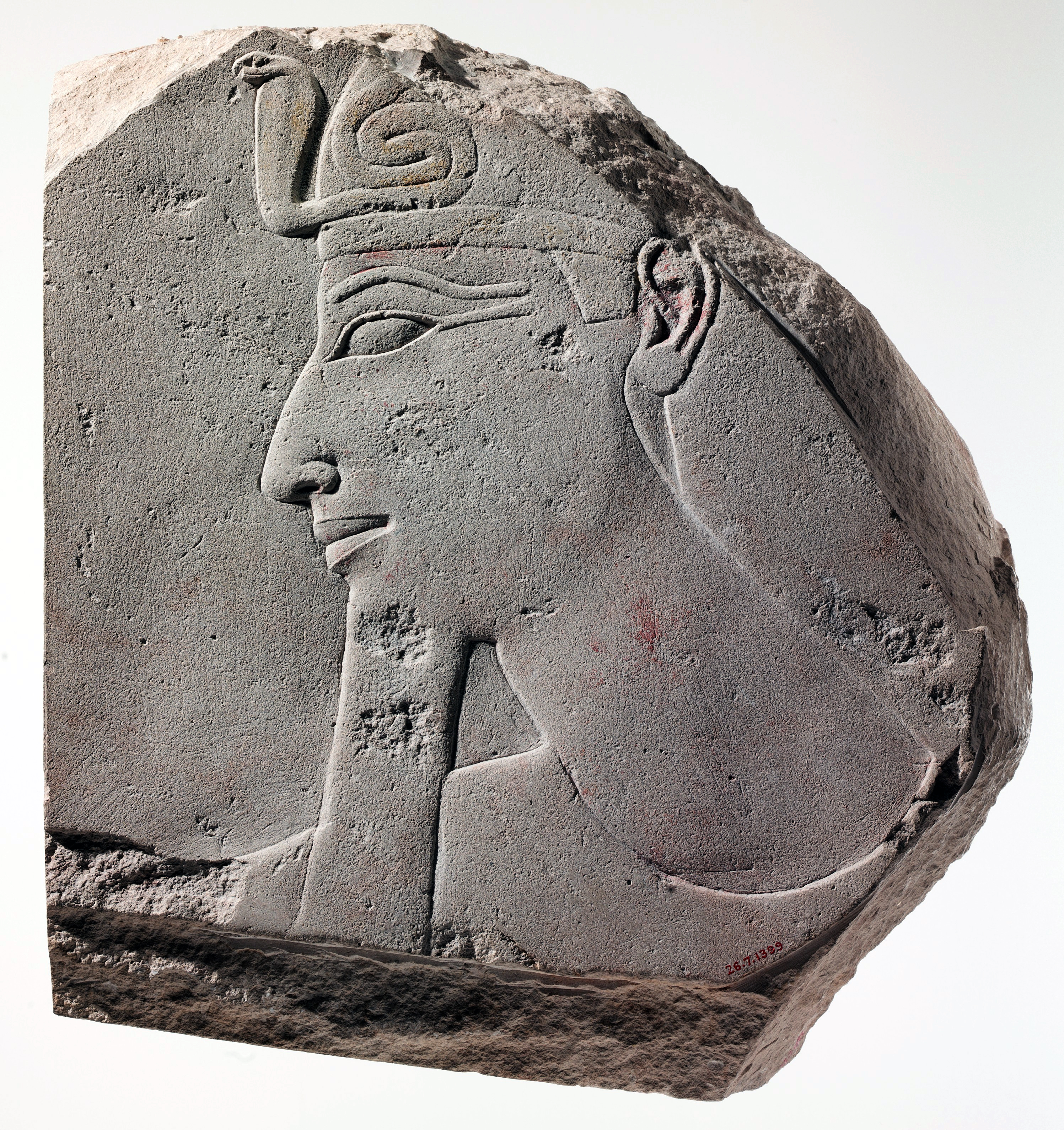
Eighteenth Dynasty: 1 550 BC - 1 292 BC
King Thutmose III
Relief of Thutmose III, circa 1 458 BC - 1 425 BC
This fine relief of Thutmose III probably came from his valley temple. He also constructed a mortuary temple against the cliffs of Deir el-Bahri at Thebes adjacent to that of Hatshepsut, with whom he shared the kingship for part of his reign. It shows the king wearing the khat headcloth with a very menacing coiled uraeus on his brow.
Catalog: Limestone, paint, Gallery 118, 26.7.1399
Photo: Met Museum
Permission: ![]() Public Domain, Open Access
Public Domain, Open Access
Source: Original, Met Museum
Text: Met Museum
_________________
An overview of the situation
The situation in which the Egyptian army now found itself is evident from the foregoing account of the progress of the council. It is apparent that the halt was made at Yemma, because, in view of the report of the spies, it was necessary for those in charge of the campaign to decide how the Ridge, lying between them and the enemy, was to be crossed. Yemma lay at, or near, the junction of three well-known roads, and it now became necessary, before advancing further, to decide upon one of these roads as the route to be pursued.
The king favoured the one known as the 'Aruna road, which we learn from the later developments of the campaign, issued from the mountains at Megiddo. It is described as being very narrow and difficult, but in this matter due allowance must be made for exaggeration on the part of the officers who desired to avoid it and who would naturally paint its disadvantages in the most lurid hues.
That this road crossed the Ridge between the two roads which the officers favoured is also evident, for one of these latter roads entered the plain towards Taanach, which is to the south of Megiddo, and the other road is specifically stated to have issued from the mountains north of Megiddo.
That the Pharaoh's officers were familiar with the country before them is evident. Possibly the spies who had been sent forward to reconnoitre had brought back information in regard to these mountain passes, though the campaigns and commerce of the preceding century must also have made the Egyptians fully acquainted with the roads of Palestine-Syria, especially with the great route to and from the Euphrates.
This same road across the Carmel Ridge apparently did not enjoy a very savoury reputation among the Egyptians. It is probably that described in Papyrus Anastasi 1, where its dangers and difficulties are dwelt on with a wealth of harrowing detail, including wild men of more than human ferocity, and deep gorges such as are scarcely found in Palestine at all and certainly not in the region of Megiddo.
Although, of course, this particular papyrus dates from several hundred years after the Megiddo campaign it still serves to show that the road was regarded as rough and dangerous, even when Syria was far better known to the Egyptians than in Thutmose's day.
Roads, especially where they are not paved, shift from age to age. In the Orient this is especially true of the roads that traverse the plains. New paths are constantly being made, their direction being governed largely by the rise or fall of towns and by shifts in the trend of commerce. One has only to note the Roman roads, remains of which still survive throughout Syria and Palestine but so many of which no longer mark lines of travel, to note how impossible it is to dogmatise on the location of an ancient road from data furnished by modern roads.
In mountainous regions, however, we have data on which to base a conclusion in regard to the location of an ancient road that do not exist in the case of more level country. We can rest assured that in ancient, as in classical, mediaeval and modern times, roads which crossed mountain ranges followed the courses marked out by nature, the passes which still exist to-day. When, therefore, we look for the roads which Thutmose's council discussed and which crossed the Carmel Ridge, we can turn to the map of the country as it is to-day and feel assured that from it we can learn with reasonable certainty the possible routes by which the Ridge would have been crossed in antiquity. That there was no road, other than a rough donkey-path, over the southern end of Umm el-Fahm is obvious from any careful study of the map. Or that any army wishing to go from the coast plain by the most direct road to Megiddo should choose any other route than that by the Wady 'Arah is difficult to conceive.
Any other course would have necessitated the scaling of a succession of rough hills, a most fatiguing and unnecessary labor, when right at hand lay a direct and easy course along the bottom of the wady which led directly to the desired goal. In the preceding description of the Carmel Ridge, I have pointed out the fact that all the passes of the mountain are occupied to-day by roads. Therefore, in discussing the situation that now confronted Thutmose, I shall take it for granted that the roads considered by the council of war were essentially the same, as far as location goes, with those that cross the Ridge to-day and the history of which we can trace back to Roman times in the remains of the paving still in situ.
A glance at the map will show the road the king advocated. The road can be none other than the one marked as Wady Arah running from Tell el-Asawir to Megiddo. The king evidently preferred to make directly for the enemy's position. The officers, on the other hand, feared the narrow mountain defile, where the army would be strung out in a long line and so would be particularly liable to attack. The enemy, sweeping down from the heights on either hand, would be able to cut such a line in two and do great damage before any united resistance could be offered. The gentle slopes leading into the wady would offer opportunities for a considerable body of men to make such a descent with ease on any army crossing the pass.
If, on the contrary, Megiddo could be approached from the side of the plain, not only would the dangers of the pass be avoided, but ample opportunity would be given for the use of the chariotry, which branch of the service would be only a hindrance in the mountain defile. The officers, therefore, advocated either one of two other roads. One of these came out of the mountains towards Taanach. This can have been none other than the one running around the southern end of the Ridge through the Plain of Arrabeh, entering the Valley of Megiddo in the neighbourhood of Jenin.
By pursuing this course, the plain could be reached considerably to the south of Megiddo and the advance on the city could then be made by way of Taanach. Here too the open plain would offer ample opportunity for manoeuvres and would enable the Egyptians to bring all their force into action at once, thus avoiding the danger of their being defeated in detail, as might be the case if they took the 'Aruna /Wady Arah road. The other road favoured by the council is less certain of identification, but The road from Tell el-Asawir to Tell Kaimun (Tel Yokneam) seems most likely to have been the 'road north of Zefti', being the counterpart on the north to the road around the southern end of the Ridge towards Taanach.
The only other route, that around the seaward end of Mt Carmel, is too great a detour to have been seriously considered.
By taking the road issuing from the mountains at Tel Yokneam, the advantages mentioned as being derived from the use of the Taanach Road would be equally well secured, except that the Taanach Road is somewhat easier for chariots. In any case it is obvious that the officers desired to reach the open country on the other side of the Ridge before encountering the enemy, hence their very evident reluctance to follow the Pharaoh along the direct road to Megiddo.
_________________
Shaming his officers into the right decision - Wady Arah!
In answer to the objections of his officers, Thutmose's anger blazed up. His reply is one of the most remarkable royal utterances in all the range of ancient oriental records and fairly rings not only with wrath but also with contempt. We can picture to ourselves the Pharaoh rising from his seat as he ends the council in disgust and with scorn bidding those of his officers who are afraid to accompany him follow the road their fears dictate, but calling upon those who would stand by him to follow his lead, adding, as a final rebuke,
'They shall not think among the enemy whom Re detests, 'Does his Majesty proceed upon another road because he is beginning to fear us?'
It is the first instance in history of one born to lead calling upon his men to follow him into danger or be forever branded cowards. And in the reply of the officers we hear not only the abject submission of the courtier who has offended royalty, but the shamed acquiescence of the soldier caught in a situation where he may be accused of cowardice,
'Behold us as following thy Majesty in whatever place thy Majesty proceeds.'
_________________
Preparations for crossing the ridge via Aruna, modern day 'Ar'arah
When the council had broken up, the king gave orders to set out on the Aruna (Wady Arah) road. It is significant that the records so strongly emphasise the fact that the king led the line of march in person. After the vigorous reprimand he had given his officers at the council, he could do no less than occupy the place of danger himself. He would thereby also be able the better to prevent any surprise by the enemy and would encourage his men by his own example. So, the necessary orders having been given for the disposition of the troops during the crossing of the mountains, the army set out.
Thutmose led his men on the march to the southern entrance to the Wady Arah. His army followed, and they came to the entrance of the narrow pass of Wady Arah unopposed.
_________________
The need for an overnight camp at 'Ar'arah
Thutmose had realised that the crossing of the ridge must occupy two days, with a camp at some point along the way, and another at the edge of the plain of Megiddo (Esdraelon), once the ridge was crossed, for the men and horses to be ready, rested, well fed and watered for the coming battle.
At the most commanding position in the pass lies the modern village of 'Ar'arah, which has been identified with the ancient 'Aruna. In support of this identification it may be argued that; first, if the road running from Tell el-Asawir to Megiddo is the 'Aruna road referred to in the Annals, then somewhere along the course of the road we must look for the city of 'Aruna as occupying a prominent position. Second, the city must have lain well within the pass, for the Egyptians had already been compelled to assume a single file formation before they reached 'Aruna.
Third, the distance of 'Aruna from Megiddo is about half a day's march, which we know from the Annals was not more than about seven or eight miles at the farthest.
( It should be noted however that to get most of the army through would take at least a day because of the narrowness of the path and the need to bring food and equipment to the scene of the coming battle - Don )
We must assume that the Egyptians would push on as fast as possible through this mountain defile so as to free themselves from the danger of attack as soon as possible, but at the same time they would have been hindered from making their best time by the confined nature of the road. Fourth, there must have been sufficient room and a sufficient water supply at 'Aruna to allow of the Egyptian army having camped there one night. These conditions are all satisfied by the location of 'Ar'arah.
For, first, it occupies the most prominent position in the pass, just at the junction of the road to Tell el-Aghbariyeh with that to Megiddo and is surrounded with sufficient cultivable land to support a fair sized population. Second, it lies well within the pass, being about two hours' journey from the mouth. Third, it is about seven or eight miles from Megiddo, just the maximum distance we would suppose the Egyptians to have travelled between 'Aruna and Megiddo. Fourth, it is abundantly supplied with water, and is located in an opening in the wady large enough to accommodate a considerable body of troops. From these considerations it seems reasonably certain that 'Aruna must have lain somewhere near the site of the village 'Ar'arah.
Etymologioally, however, it seems hardly possible to equate 'Aruna with 'Ar'arah. If we are right in this identification of 'Aruna with the modern 'Ar'arah, then shortly after leaving Yemma the host would have entered the mouth of the Wady 'Arah and would have found itself in the situation which the officers of the army dreaded so much, where it was impossible to maintain any other than a long drawn out line of march. With this necessity of the topography the account in the Annals entirely agrees, for upon leaving Yemma, the Egyptians are said to have marched, at once, 'horse behind horse', in the single file formation that the narrow valley demanded. It is not to be supposed that even on the coastal plain from Gaza to Yemma the army had marched in any other than column formation. In most parts of the valley also this formation could be more or less maintained. If, however, the enemy had attacked the army in the open plain, it would have been possible for the Egyptians to have formed in some sort of battle-array. In the mountain pass, on the other hand, the long, straggling column necessitated by the narrow road could not have been organised into any sort of formation. It is on this account that the record so strongly emphasises the straggling line which the country necessitated.
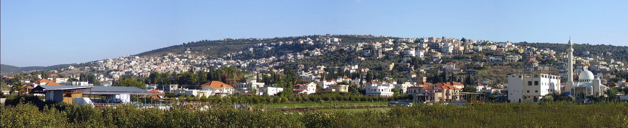
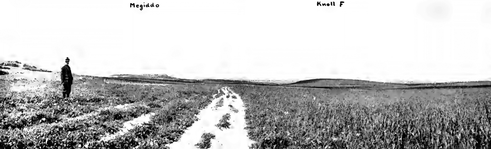
Ar'arah panorama
Modern day Ar'arah (or Ar'ara), showing how suitable the spot is for a large army to camp for the night.
There was water and plenty of space for the tents, horses and equipment, only a mile or so to the east of the narrow Wady Arah.
Photo: RickP
Permission: Creative Commons Attribution-Share Alike 3.0 Unported license.
_________________
Arrival at 'Aruna / 'Ar'arah, high on the ridge before Megiddo
Three days after leaving Yemma the Egyptians were at 'Aruna. We are not to suppose that it took three days to cover the distance between the two towns. If we are right in putting Yemma somewhere near the junction of the three roads across the Ridge, it would not have taken more than one day for the army to have reached 'Aruna. It is possible that the spies sent out to locate the enemy were not dispatched till after Yemma was reached, in which case it would have been necessary for the king to wait a day or two at Yemma for their return. It is not necessary to suppose that the council was called on the sixteenth. That date possibly indicates the time of arrival at the city, at which the king may have remained for several days. We must suppose that as soon as possible after the announcement of the king's decision to cross the Ridge directly to Megiddo, the advance was begun, for there would have been no object in delay, as far as our information goes.
The nineteenth of the month was therefore occupied in the march to 'Aruna, at which place the Egyptians camped that night. Provided the location of Yemma as given above is in general correct, it would have been possible for the king to have pushed on further that night before camping. But in that case nightfall would, in all probability, have found the army still toiling through the pass, and they would have been compelled to halt so near to Megiddo that their camp would have been exposed to attack by the enemy had the latter been vigilant. Moreover, at 'Aruna there was a good camping-place with plenty of water, a favourable situation found nowhere else on the road. Furthermore, the distance from 'Aruna to Megiddo, as shown by the time occupied in crossing the pass the next day, was just about enough to allow the Pharaoh to get his entire army through the mountains in the course of the day and enable them to prepare for battle on the morrow.
_________________
The offical report of the battle
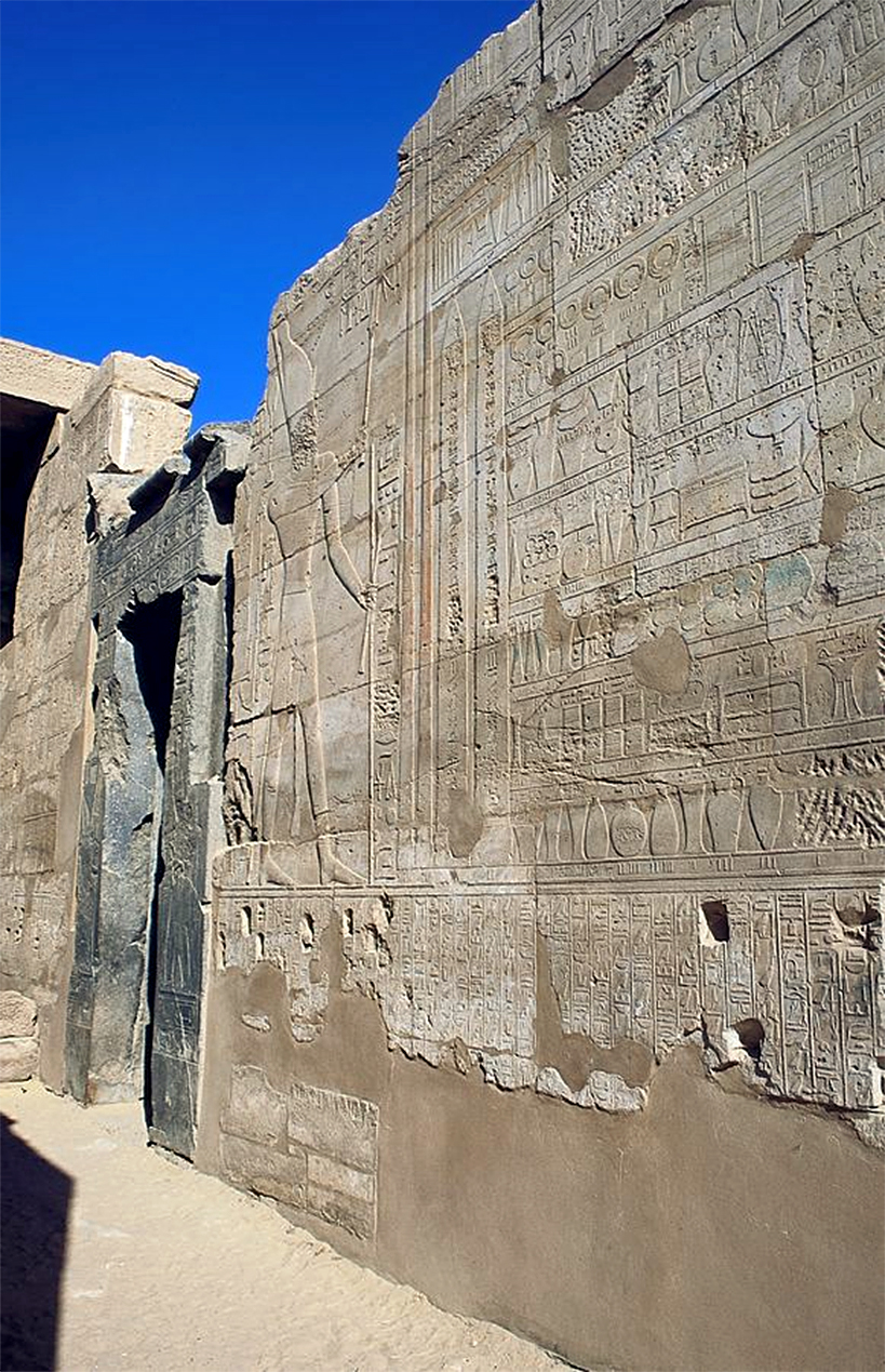
The 'Annals of Thutmoses III' at Karnak. His figure stands in front of offerings made to him after foreign campaigns.
These annals detail the campaign of Thutmose III, culminating in the Battle of Megiddo.
Photo: Jon Bodsworth
Permission: the copyright holder of this work allows anyone to use it for any purpose including unrestricted redistribution, commercial use, and modification.
From the report:
'His Majesty commanded to issue orders to the entire army concerning this narrow road. Behold his Majesty took an oath, saying, 'I will not permit my victorious army to set out in advance of my Majesty.'
He set out in advance of his troops himself. Every man was assigned his position, horse behind horse, his Majesty being at the head of his troops.
Now the rearguard of the victorious troops of his Majesty was at the city of 'Aruna when the vanguard issued at the valley of the Kina. They filled the mouth of the valley. Then they said in the presence of his Majesty,
'Behold, his Majesty goes forth together with his victorious troops and they fill the valley. Let our victorious lord harken to us this time and let our lord guard for us the rear of his troops and his people. When the rear of the troops goes forth for us, then we shall fight against these Asiatics; then we shall not give thought to the rear of our army. His Majesty halted outside, waiting there, guarding the rear of his victorious army.'
Now the rear of the expedition was going out upon this road, when the shadow turned ( i.e. local noon - Don ), and his Majesty arrived at the south of Megiddo on the bank of the Brook Kina, when it was seven hours from the turning of the sun.
Then the camp of his Majesty was pitched there and command was given to the entire army, saying,
'Prepare yourselves; make ready your weapons, for we will advance to fight with this wretched enemy in the morning.'
Wherefore one was proceeding to rest in the royal tent. The officers were provided for. Provisions for the court were secured. The sentries of the army made the rounds.
They said, 'Steadfast! Steadfast! Watchful! Watchful!'
The royal bodyguard was at the royal tent. One came to report to his Majesty,
'The land is well, the troops of the north and the south likewise.'
_________________
The Shrine of Amun
In the passage of the mountains the king led the way accompanied by, or, in the words of the Annals, 'bearing' his father, Amon. This is the only instance I know of in Egyptian records where we are told that statues or images of the gods were carried into battle, as the Hebrews carried the ark. The image of Amon in its portable shrine, born on the shoulders of a body of priests, undoubtedly accompanied the van of the army where the king's chariot was and 'opened the way' before his Majesty.
On the walls at Medinet Habu is a relief (above) depicting the departure of Ramses III for the first Libyan campaign. Before the king is a chariot bearing the standard of Amon, a ram's head surmounted by the sun-disk, the whole supported on a pole attached to the chariot. Above the chariot is an inscription which reads: 'Utterance of Amon-Re, king of gods: 'Lo, I am before thee, lord of the Two Lands, Usermare-Meriamon. I give to thee all might and power among the Nine Bows; terror ...... their chiefs, I will open for thee the ways of the land of Temeh. I will trample them before thy horses.'
It is interesting that this phrase 'open the ways', so common in the inscriptions, should be so graphically illustrated by the chariot of Amon preceding the king along the road to Libya. Is it not more than likely that in Thutmose's inscription, where the king is said to be carrying his father Amon who in turn 'opens the way' before him, we have just such another scene as that shown at Medinet Habu. We know of instances where portable cult images were carried far from Egypt, such as the image of Khonsu which was sent to the land of the Hittites by Ramses II, or the image of Amon-of-the-Way that Wenamon carried to the king of Byblos. The divine names given to the four divisions of Ramses II's army on the campaign of Kadesh suggest that perhaps each division of the army bore an image of the deity under whose special protection it marched.
Thutmose III, who owed his elevation to the throne to the intervention of Amon, might well emphasise the presence of the deity at the head of the expedition which was being carried on ostensibly at the god's command.
Photo: Gressmann (1909)
Text: Nelson (1913)
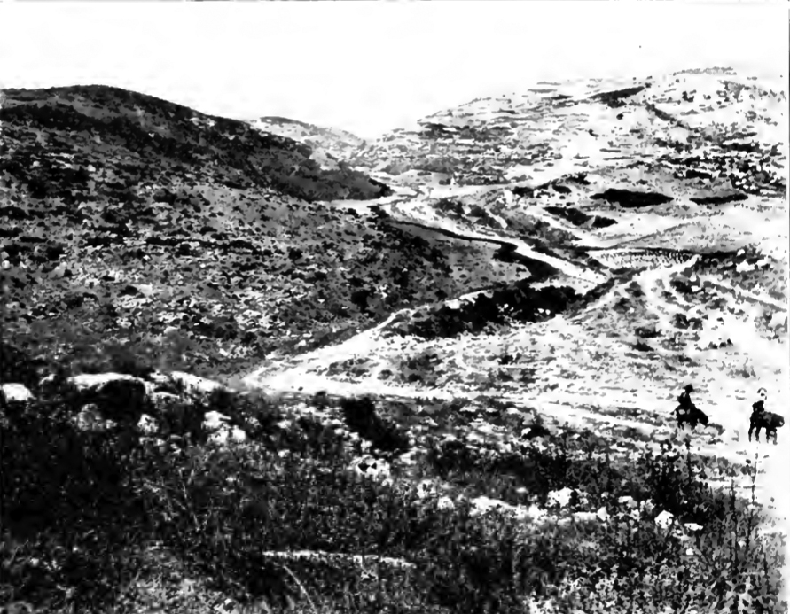
Looking southwest along the Aruna Road / Wady Arah from a point about a mile above the northern opening of the valley.
Photo and text: Nelson (1913)
_________________
The exit from the pass
As the king, at the head of his army, reached the mouth of the pass at noon after travelling for seven hours from first light, the open plain of Megiddo by the Kina Brook was revealed.
The Egyptian vanguard formed up in battle-line, ready to resist any attack by the Asiatics, and to cover the main body of the army still pushing through the mountains behind.
Highway 65 follows the route of Wady Arah. As can be seen here, the Wady was narrow right until its debouchement onto the fertile plain of the Esdraelon, at which point the vanguard of the army could see Megiddo, and the battle ground ahead.
Photo: © Google Earth
At this point, the rearguard was still far behind on the other side of the Ridge at 'Aruna, the point from which the vanguard of the army had set out in the morning. The officers who accompanied the king at the head of the army must have watched the opening of the valley with anxious eyes to catch a glimpse of the whereabouts of the enemy and to make sure that their fears, as expressed at the council at Yemma, were not about to be realised.
As the army turned the last bend of the road, several hundred yards before it enters upon the plain, they found that the valley spread out to a couple of hundred yards in width while the slopes of the hills rose gently on either hand. The eager troops behind, pushing rapidly forward, not only to see what lay ahead, but also, no doubt, to free themselves from the dangerous position in which the narrowness of the pass placed them, soon filled the mouth of the valley and, we must suppose, in the case of the infantry, even the slopes of the hills. What they saw before them was the wide expanse of level land, probably covered with ripening harvests, stretching for half a mile to the banks of the Kina, and beyond, about a mile away, the walls of Megiddo, the stronghold of the enemy and their own objective.
Beyond the city lay the fertile plain of Esdraelon, with its grain fields and orchards, extending away to the blue hills of Galilee. No doubt between the Egyptians and the open plain was the northern wing of the Asiatic army, now probably in great commotion as they realised that their enemy had done the thing they had not calculated on happening, and had surprised them with the bulk of their force far down the road towards Taanach.
They had obviously discounted not just the 'Aruna Road from their calculations, but also the route via the road north of Zefti, exiting at Tel Yokneam, and had concentrated their preparations based on Thutmose having chosen the easiest path for his chariots, along the Taanach Road.
And no doubt in the Egyptian ranks many an officer and private looked with longing eyes at the open spaces of the great plain between which and themselves lay the enemy, and thought with fear of the long, straggling line of troops hastening over the hills at the mercy of any strong force which might swoop down on them from the heights on either hand.
At this point the officers plucked up courage to make one further request of the king:
'Let our victorious lord harken to us this time'
they said, even though he had seen fit to disregard their advice at Yemma. They then called Thutmose's attention to the troops behind him, who were gradually filling the mouth of the valley, as one by one the companies of infantry and 'squadrons' of chariots filed out of the narrow road and took up their positions in the rear of the waiting vanguard.
They urged the king to wait at the mouth of the pass until all his troops had arrived, so that when the army finally emerged into the open, they might give all their attention to the enemy in front and not have to weaken their strength by being compelled to detach a portion of their force to cover the arrival of the straggling rear.
Now that Thutmose had actually reached Megiddo and had shown the feasibility of his own plan of campaign, he seems to have consented willingly to their suggestion, also, no doubt, realising the wisdom of not dividing his army in the face of the enemy. By stationing a sufficient force on the hills on either side of the mouth of the valley, he could command a strong position. On his left was a long ridge, two or three hundred feet high, which sloped down on the south into the valley in which the army then stood, and on the north was protected by the wide opening of the Wady es-Sitt, from which flowed the Brook Kina.
On the south of the valley mouth was another equally high hill which, though bounded by a more shallow wady on the other side could still be held against the attack of a large force. With these two heights in his possession, and we cannot suppose that he failed to seize them at once, and with his vanguard, undoubtedly composed of picked troops, facing the enemy in front, he might feel reasonably safe from any attack by his foes that day until the rearguard had finally made its passage of the mountains.
By gradually advancing his front into the open but still keeping the mouth of the valley well covered, he could make room for the fresh arrivals as they came up, until, when all had safely crossed by sunset, and no battle could be expected that day, he could advance boldly with all his force into the fields bordering on the Kina, with enough light left to make the final touches to the setting up of camp. Guards would already have been posted at nearby selected high points on the plain, and scouts sent out to report on the preparations and positions of the Asiatics for the battle which would come on the morrow.
The Asiatics would have already recalled their troops from the Taanach Road, and be readying for battle on the outskirts of Megiddo.
At this point in his narrative the Annalist furnishes us with a most interesting datum. He says :
'Now when the rear of the expedition was setting out upon this road, the shadow turned; and his Majesty arrived at the south of Megiddo on the bank of the brook Kina, when it was seven hours from the turning (measured) by the sun.'
( Note that this translation does not agree with the earlier translation, when it was stated that it was the rearguard that set out from 'Aruna, at the turning of the sun (i.e. noon) whereas Thutmose would have set out at sunrise, and would have arrived at about noon, seven hours from when he left. The annals had also stated that the distance was seven or eight miles at most, a half a day's march.
At that point his officers pleaded with him to wait until the rest of his army had made the journey before commencing hostilities. The rearguard also took seven hours to get to Megiddo, but as was previously stated, they did not set out until the 'turning of the sun' and arrived seven hours later, at sunset, the same journey time as the vanguard - Don )
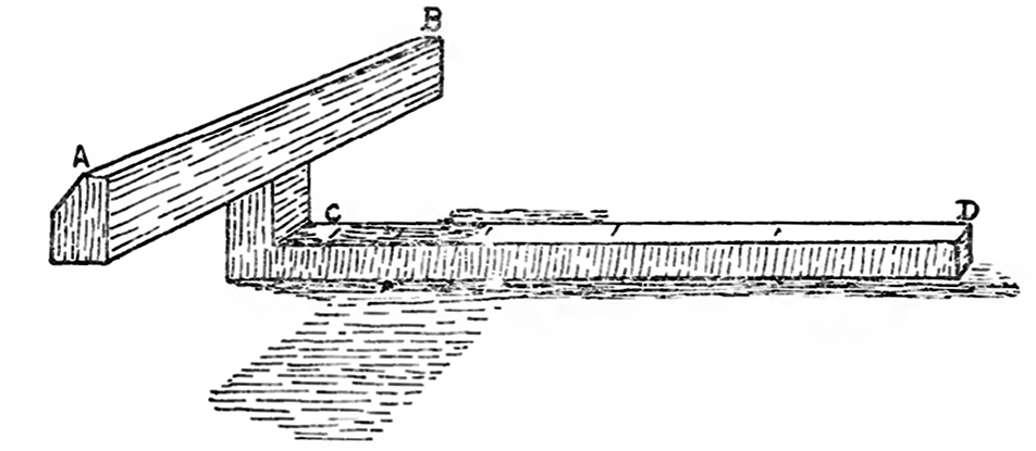
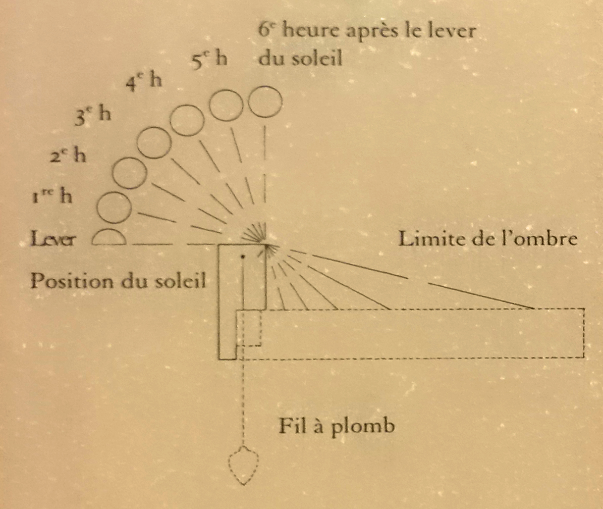
So far as I know this is the only instance in the Egyptian records where an event is timed, as we today would time it, by the hours of the day. Taking this passage in conjunction with Borchardt's study of Egyptian sun-clocks, we are able to ascertain the time of the king's arrival at his camping place down to the very hour of the day. Borchardt's article is based on the study of the remains of two such clocks, one of which bears the inscription: 'Living Horus, Mighty Bull Shining in Thebes, the Beloved of the Two Goddesses, etc. etc.. King of Upper and Lower Egypt, Menkheperre (Thutmose III), Son of Re ', showing that in the reign of Thutmose III such instruments for measuring time by the sun's shadow were already in use.
Photo: Borchardt (1911)
According to Borchardt's reconstruction (see the diagram above) the instrument was placed so that the transverse piece A-B lay in a north-south direction, while the longitudinal section C-D would then extend in an east-west line. The shadow cast by A-B on C-D would gradually shorten as the sun rose, until at noon time, when the sun stood directly over head, there would be no shadow upon C-D at all. The longitudinal section was divided into six parts to correspond to the six hours of the morning, and as the shadow cast by A-B retreated from one of these parts to another the observer could ascertain with tolerable exactness the time of day. To tell the afternoon hours it was necessary to reverse the instrument so that it would face the west, and the progress of the hours would then be indicated by the lengthening of the shadow cast by the transverse A-B upon C-D.
This brief summary of Borchardt's reconstruction of the working of Egyptian sun-clocks gives us the data necessary for the understanding of the Annalist's statement that the shadow turned. Obviously by this phrase he referred to the time at which the shadow, instead of withdrawing towards C, turned around, as it were, and began to lengthen out towards D after the reversal of the clock.
The turning of the shadow would then indicate noon, the hours before the shadow turned belonging to the morning, and those after the shadow turned to the afternoon. The turning of the shadow cannot very well apply to sunrise, and so many hours after the turning would therefore not refer to the morning hours.
To speak of the shadow turning instead of the clock being turned would be no more inconsistent than are many of the terms in popular use today, as when we speak of the sun going down, etc.
It is evident that the rearguard of the Egyptians left 'Aruna at noon or shortly after, that is, when the shadow turned, and that the king reached the banks of the Kina at seven o'clock in the evening, that is, seven hours from the turning (measured) by the sun.
_________________
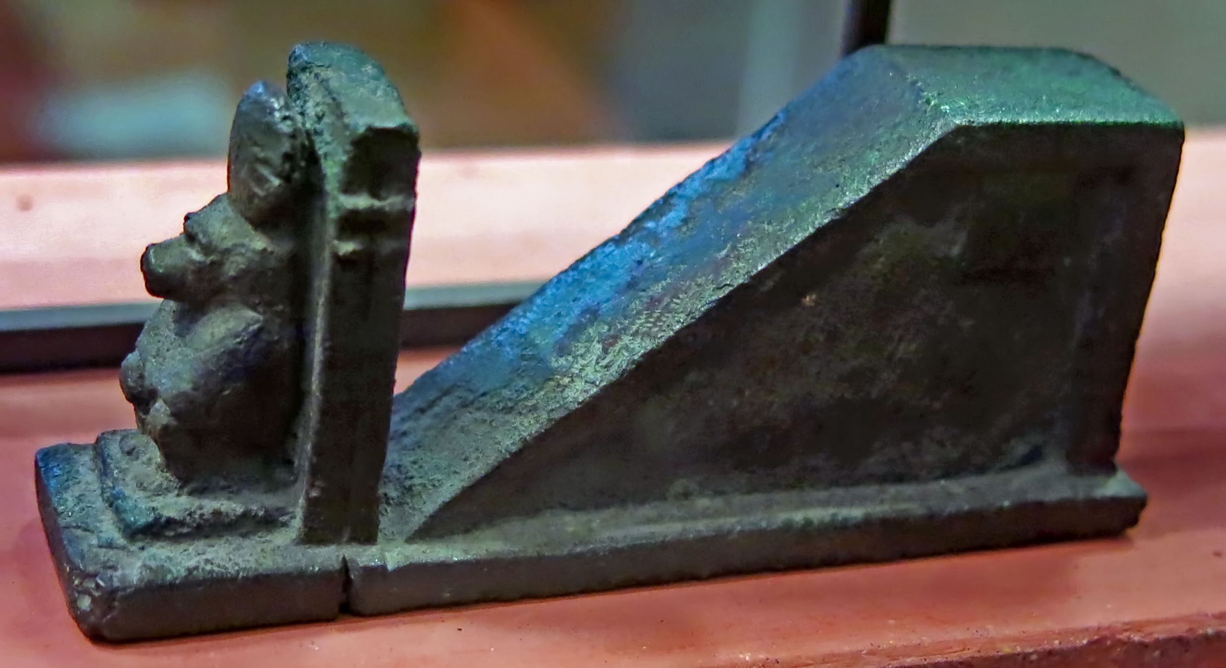
( Note that there are several errors of fact in the above, and the shadow clock shown would not have been suitable for use in the field.
The small bronze shadow clock shown below would be ideal for an army on the march.
As detailed below in the actual physics of the situation, and also illustrated below with actual shadow clocks, or gnomons, at no time in the delta of Egypt, or further north at Megiddo, is the sun ever directly above. Memphis for example lies at 30°N. The sun is directly overhead at noon only twice a year for a site within the tropics, between 23.5° south and 23.5° north. In addition, the elevation of the sun changes regularly from day to day, and most obviously from midsummer, when shadows are short at noon, to midwinter, when shadows are long at noon.
The diagram is stated to be from historical shadow clocks, but there is no need for the wide gnomon at right angles to the main body of the clock, and especially if the clock is to be transported by an army on the march. This may be seen in the first gnomon shown below, N 781 in the Louvre, where the wide gnomon has been reduced to its essentials, as a vertical 'post' as wide as the grooved part of the shadow clock.
In addition, in use the shadow clock would always be pointed straight at the sun, so that the shadow of the gnomon was at right angles to the rod, and parallel to the marks on the rod.
The instrument would not need to be 'reversed' after noon, it would have been pointing directly at the sun all the time it was being used, changing by small amounts as each measurement was made. At noon the shadow would have been smallest, and if there was a mark at exactly one hour before noon, this same mark two hours later would represent one hour after noon.
All measurements would have been to a greater or lesser extent approximate, and would have to have been used by someone with knowledge of the changes in elevation of the sun from season to season. For the 'seven hours' estimation, this would at this season have approximately corresponded to the setting of the sun, and no shadow clock would have been pulled out to verify this fact.
The Egyptian day was divided, as ours is, into 24 hours.
Thus seven hours from the turning of the sun means 7 pm. At Megiddo at this time of the year the sun would actually have set at 6 hours 45 minutes after local noon, though we should not read too much into this accurate answer with our modern viewpoint and access to very reliable digital clocks. Thutmose (or his scribe) probably just used sunset as '7 hours after noon' because that is when the sun sets in full summer, a month or so later, hardly important in this context.
The point was that there would have been plenty of daylight for the next hour or so in order to finish setting up camp, organise the latecomers, and make preparations for the battle on the next day.
The Egyptians had reasonably accurate water clocks (clepsydra) to calibrate shadow clocks of the types shown below.
Thutmose would have known perfectly well that the sun set at about seven pm in summer, just as today's farmers know at approximately what time the sun goes down at a certain time of the year
- Don )
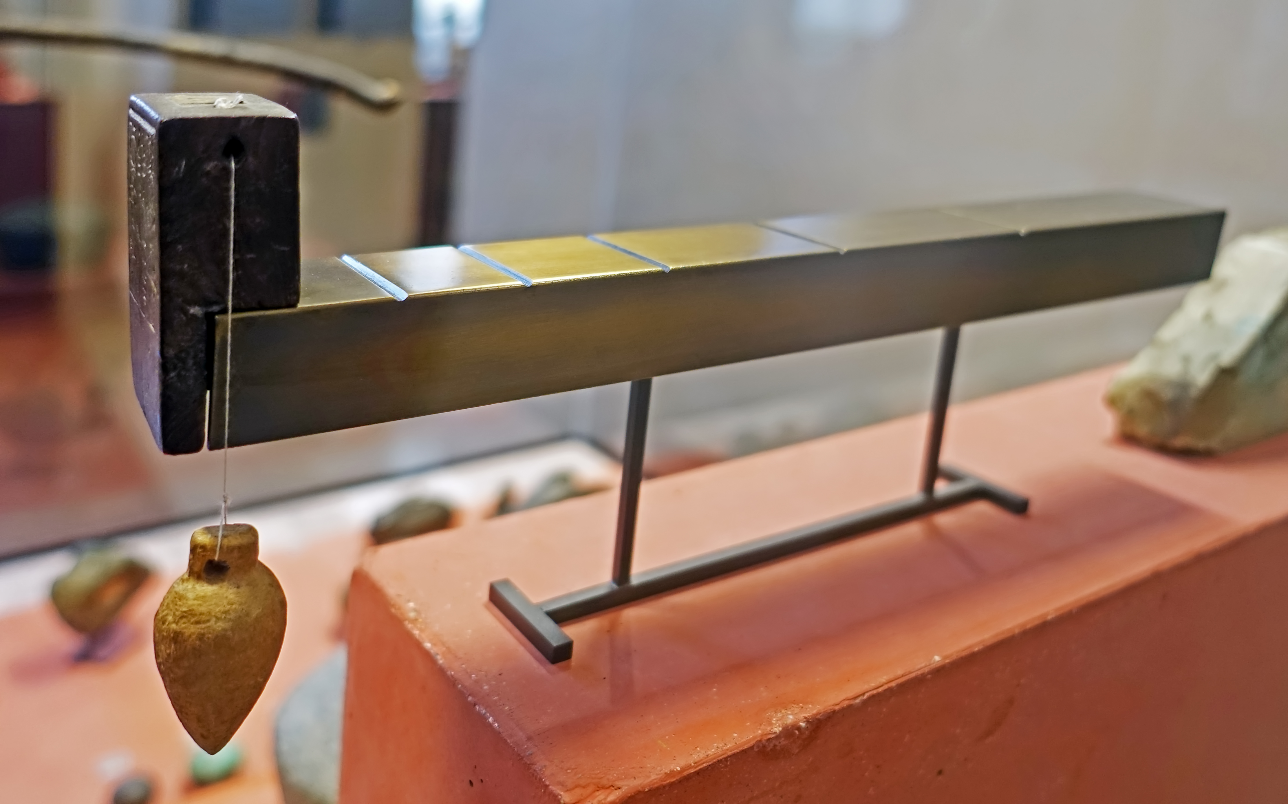
Eighteenth Dynasty: 1 550 BC - 1 292 BC
Gnomon
Amenhotep III
Wooden shadow clock, or gnomon. A lead weight or plumb bob is used to make sure that it is level.
Circa 1 388 BC - 1 350 BC
Height 50 mm, length 32 mm, thickness 19 mm
( Note that the diagram is not correct for either Memphis at 30°N or Megiddo at 32.5°N, the diagram assumes that the sun is directly overhead at noon. In the case of Megiddo at that date (May 15th) the sun at noon would have been at an elevation of 75.5°, circa 15° off the vertical. Also, only at the equinoxes are there twelve hours of sunlight. In addition, the gnomon would have had to be rotated anticlockwise as the sun rose (and fell) in the sky, to keep the shadow aligned exactly on the markings.
This shadow clock does take account of the fact that the sun is never overhead at the populous delta of Egypt, nor further north. The first mark on the rod is for noon, the other four are for 1, 2, 3, and 4 pm respectively, with the end of the rod serving as the marker for the shadow at five pm. No mark is needed for six pm, since that is when the sun sets for much of the year (or earlier), and the shadow is horizontal, and would not fall on the rod. Adjustments to the estimation of time would have been necessary in winter, when the sun sets at around five pm, and summer, when it sets at about 7 pm. Great accuracy must not be expected from a clock such as this, it simply gives an approximate but useful value for the time of day. Noon, or the 'turning of the sun' is the only accurate reading except for the season that the clock is set up for, possibly around the equinox.
Since the clock would have to be calibrated for all seasons of the year, and perhaps for different places further north and further south, it would not be unreasonable to make up a set of papyrus overlays on the horizontal rod to cover all eventualities, including the season of the year for a particular latitude.
- Don )
Catalog: Wood, N 781
Photo: Don Hitchcock 2018
Source, text and diagram: Original, Louvre Museum, http://cartelfr.louvre.fr/cartelfr/visite?srv=car_not_frame&idNotice=3409&langue=fr
21st - 31st Dynasty: 1 077 BC - 332 BC
Gnomon / Shadow Clock
Bronze gnomon, circa 1 069 BC - 332 BC.
Under the protection of the god Thot, shown as a baboon.
Height 35 mm, length 81 mm
( This shadow clock has several advantages. It is small and portable, and it is virtually unbreakable even under misuse. In addition, by having a sloping section where the shadow is cast, it can measure the time even when the sun is low in the sky, at six pm in midsummer, with sunset at 7 pm. I would assume that three columns of markings for midwinter, the equinox, and midsummer would have been painted on the sloping section where the shadow is cast. There is a hole near the top of the vertical part of the gnomon to accept a cord (and attached weight, now lost), with a groove in the base directly beneath to accommodate the cord, and show that the base of the gnomon was thus horizontal - Don )
Catalog: Sully, Rez-de-chaussée, L'écriture et les scribes, Salle 335, Vitrine 6: Poids et mesures, E 11558
Photo: Don Hitchcock 2015, 2018
Source, text and diagram: Original, Louvre Museum, https://collections.louvre.fr/en/ark:/53355/cl010007834
_________________
The camp at the opening of the valley
If the king waited at the opening of the valley for the arrival of the rearguard and then at once moved forward to the night's camping place, it would seem that it took the rearguard seven hours to cross the Ridge, about the time that we would expect to be consumed in the passage by troops encumbered with camp furniture and all the motley array that accompanies an army on the march.
If, therefore, it took the rearguard seven hours to march from 'Aruna to Megiddo, we must suppose that the van had consumed much the same time in covering the same distance. As the king was at the mouth of the valley at least by noon, for the rearguard which left 'Aruna at noon did not leave till after the van had crossed the Ridge, he must have started from 'Aruna at least by five o'clock in the morning, the whole day being thus consumed in the passage. In Palestine in the month of May it would still be bright daylight at seven in the evening and the entire army would therefore have reached its camping-place well before dark.
Looking from the opening of the 'Aruna Road toward Megiddo and the Plain of Esdraelon.
Photo and text: Nelson (1913)

Sketch map of the battlefield.
Drawing: Nelson (1913)
The spot chosen for the Egyptian camp was most certainly the expanse of level ground extending along the south bank of the Kina. A more suitable location could not have been chosen. Here was an ample stretch of flat land just at the opening of the pass (see Map III above). By camping here the army secured its line of communication with the south by which it had just come from the other side of the Ridge. In addition, the wady of the Kina served as a defence on the two sides (approximately to the west and north) most exposed to attack from the direction of Megiddo. The stream furnished abundant water for both men and animals.
Moreover, if the Egyptians posted a force on the knoll F, they would be able to prevent attacks from the east during the night. It is obvious that the Egyptian army did not move out into the open Plain of Esdraelon, for to do so they would have been obliged to pass through the forces of the enemy who held the road to Taanach and, had they succeeded in doing so, they would have been cut off from their line of communication over the Ridge.
Furthermore, the Annals would seem to indicate that the bank of the Kina south of Megiddo, at which place the army arrived at seven in the evening, was the spot where the camp was pitched. Any location on the bank of the brook out in the open plain would not have been south, but east or north, of Megiddo, and throughout the Annals the writer is quite accurate in the indication of direction. Also the location of the camp at this spot falls in well with the operations in the next day's battle.
Our knowledge of the appearance of an Egyptian camp is largely drawn from the battle reliefs of Ramses II. These have been so frequently and so fully described that it is not necessary to enter into a discussion of the subject here, especially as it does not bear directly on the problem before us. Suffice it to say that, if we may trust the reliefs, Ramses' camp was bounded by the shields of the troops set up on end so as to enclose a large rectangular piece of ground.
In the centre of this inclosure stood the royal tent, around which were camped the troops and camp followers. Such in general we may suppose to have been the arrangement of Thutmose's bivouac by the Kina. The Annalist gives us a glimpse into the routine activities of the camp that shows us how orderly war had already become even in this remote age. First of all orders were issued to the troops to prepare themselves and their weapons for the morrow's conflict, and we may picture to ourselves the busy scenes as bowstrings were tested, arrows, spears and knives sharpened, chariot wheels examined, and all the military accoutrement put in order. The king withdrew to his tent, doubtless to consult with his officers and decide upon the plan of action to be followed in the morning as based on the topography of the immediate environs of Megiddo.
Some such consultation must have taken place, for it is evident that the next day's conflict was no haphazard engagement but a well-ordered, well planned and executed battle with all the physical features of the region taken into consideration.
The phrase which I have translated, 'The officers were provided for' may possibly refer to the issuance of these orders to the various officers of the army. The words used are quite obscure, but would seem to refer to the distribution of rations to the troops or court. Then follows the statement that the watch made its rounds and that the royal bodyguard was stationed at the royal tent. Then, when all these preparations had been carried out, report was made at headquarters, to put it in modern terms, that 'all's well'. The army had settled down to rest before the arduous duties of the next day.
Of what was going on across the Kina among the Asiatics the Annalist has told us nothing. We can only surmise the movements of the enemy. That they were taken by surprise is evident from what has gone before. They had apparently made their preparations for meeting Thutmose in the direction of Taanach, and when they discovered that he had taken them in the rear, their consternation must have been great. As, however, Thutmose did not advance from the mouth of the pass for some five hours or more after the Egyptian vanguard had accomplished the crossing, the Asiatics would have had abundant time to recall their main body from the direction of Taanach, only about four or five miles away, and to prepare to meet the Egyptian advance on the following day.
The Asiatics would undoubtedly have pitched their camp so as to place it between the Egyptians and the city. No more favourable location for a camp could have been found than the almost level top of the mound G just south of Megiddo. It is an elevated piece of ground that could therefore be more easily defended than a lower situation, while by choosing this spot the Asiatics could protect the city on its weakest side where the wall was lowest and most accessible.
We must also suppose the camp to have been located at about this spot, rather than on the lower land to the west, north or east of the city, for on the next day when the centre and right of the Egyptians closed in from the west and south of the city, they seem to have charged directly through the camp of the Allies. To have made this possible the camp must have been located at about the spot indicated above. As to what went on in the Asiatic quarters that night, the Annalist has given us no information and it is useless to speculate on such a subject.
It seems evident that, of the three roads across the Ridge, the Zefti road did not enter seriously into the calculations of the Asiatics. Had they anticipated an attack from the Zefti road, they would most probably have advanced a portion of their force along the road north of Megiddo, a movement which does not seem to have been undertaken at all.
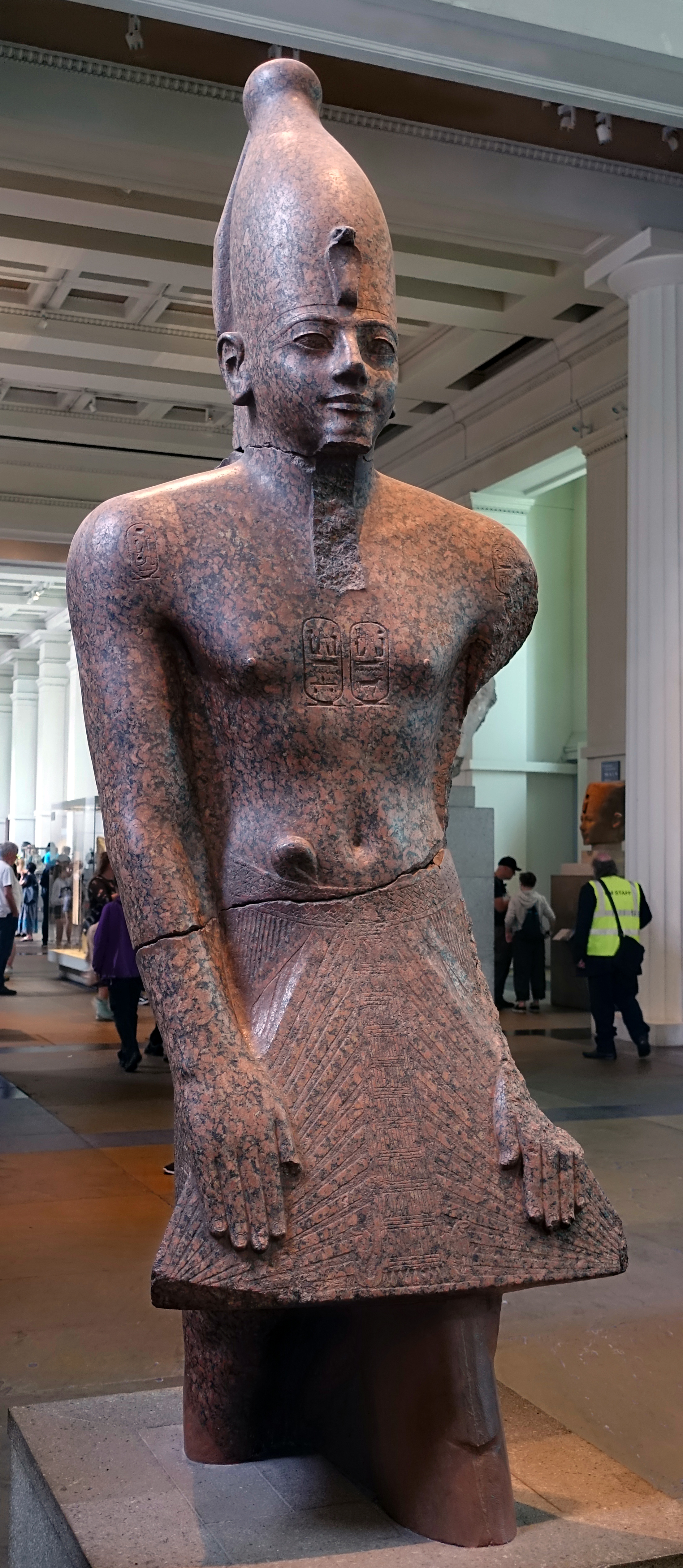
Eighteenth Dynasty: 1 550 BC - 1 292 BC
King Thutmose III
The king wears the white crown of Upper Egypt, with a protective cobra emblem representing the goddess Wadjyt. A long flaring beard has broken away. The hands are in a pose of devotion.
Catalog: Granite, EA61
Photo: Don Hitchcock 2018
Source: Original, British Museum
Text: Card with the display at the British Museum, © Trustees of the British Museum, CC BY-NC-SA 4.0, http://www.britishmuseum.org/
_________________
The Annals, lines 84 - 90
Year 23, first month of the third season, day 21; day of the feast of the new moon as usual. The king appeared early in the morning. Then orders were issued to the entire army to cross the valley of the Kina. His Majesty proceeded in a chariot of electrum, clad in his accoutrements of war, like Horus the Valiant, Lord of Offerings, like Montu of Thebes. His father Amon was strengthening his limbs. The south wing of the army of his Majesty was at a hill south of Kina, and the north wing was at the north-west of Megiddo, his Majesty occupying the centre. Amon was the protection of his members, the power of the might of Set was the strength of his limbs.
Then his Majesty prevailed against them at the head of his troops, and when they saw that his Majesty prevailed against them, they fled headlong to Megiddo with faces of fear. They abandoned their horses and their chariots of gold and of silver. They drew them up by hoisting with their garments into this city. Now the people had shut up this city against them and they let down garments to hoist them upward into this city.
Now had the troops of his Majesty only not given their hearts to plunder the possessions of the enemy, they would have plundered Megiddo at this moment, while the wretched enemy of Kadesh and the wretched enemy of this city were drawn up to secure their entrance into their city, the fear of his Majesty having entered into their limbs. Their arms were weak. His serpent diadem had prevailed against them.
Then were easily captured their horses and chariots of gold and silver Their battle-array was lying stretched out like fishes in a corner. The victorious troops of his Majesty went around counting their respective portions. Then was captured the tent of that wretched enemy, which was worked with silver. The entire army was rejoicing and giving praise to Amon for the victory which he had given to his son on this day.
They gave praise to his Majesty, exalting his victory, They brought up the spoil they had taken, consisting of hands, of living prisoners, of horses and chariots of gold and silver and of painted stuff.
( It was the custom to cut off the right hands of slain enemies and count them to keep track of the measure of their victories - Don )
His Majesty commanded his army, saying, 'Capture ye victory. Behold, every land is given to my Majesty according to the command of Re this day; for every chief of every northern country which has revolted is within it; for it is the capture of a thousand cities, the capture of Megiddo. Capture ye, capture ye, thoroughly!'
_________________
The direction of the attack upon the Asiatic lines
Sketch map of the dispersion of the troops.
Drawing: Nelson (1913)
At this point it is necessary to determine from just what direction the attack upon the Asiatic lines was delivered on the following day. Our data for reaching a conclusion on this subject are woefully meagre and leave us at the last not quite satisfied.
Only two statements are made in the Annals in regard to the location of the Egyptian lines. First, 'Then orders were issued to the entire army to cross the valley of the Kina', and, second, 'The south wing of the army of his Majesty was at a hill south of Kina and the north wing was at the northwest of Megiddo, his Majesty occupying the centre.'
One other fact may be added to this scanty information, namely, that the Asiatic camp most certainly lay between the Egyptian army and the city, for, as has been already pointed out, the Egyptians, in pursuing the Asiatics fleeing into the city after the battle, came upon the latter's camp and stopped to plunder it.
The camp, therefore, very likely lay almost opposite the Egyptian centre, so that the troops converging on the city all fell to plundering the possessions of the enemy. Had the camp lain to one side, it is likely that at least a part of the army would have continued the pursuit of the fleeing foe up to the city walls. On these few facts and this one deduction must rest the decision as to the direction from which the Egyptian attack was made.
'The northwest of Megiddo' and 'the hill south of Kina' mark the two extremities of the Egyptian lines. The former must refer to the strip of cultivated land between the Tell and the hill A, that is, at or near the northern end of this strip of land where it opens into the plain of Esdrselon.
The 'hill south of Kina' is undoubtedly the knoll F. Being a detached eminence it would easily serve as a defensible termination to a line of battle. By occupying this rise the Pharaoh could protect the southern wing of his army and until it moved forward away from the knoll, could prevent the enemy from turning his right flank.
Either C or D, the other two hills which might be considered south of the Kina, are so much in line with the hills on either side of them that they would hardly serve as a natural defence upon which to rest one wing of the army. Nor do they stand out prominently enough to serve as a distinctive designation of location.
Moreover, as the steepness of the bank of the Kina where it skirts the south side of the mound H, is too great to allow of troops making an effective attack on H from that direction, the right or south wing of the Egyptian force must have been compelled to move round mound H to the east to attack the Asiatic south wing.
If, therefore, the southern extremity of the Egyptian line rested on knoll F before the battle, the Pharaoh's troops would have been in a position to advance directly against the enemy defending the east side of the group of mounds.
If, therefore, we take the knoll F as the 'Hill south of Kina', we must then decide whether the Egyptian line of battle faced the city from the west and south of Megiddo or from the open plain to the north and east, In either case it would be possible to station the troops so that one wing would be to the northwest of the city and the other wing would rest on the knoll F.
Had the Annalist but seem fit to designate the wings of the army as right and left, we would then be able to locate the Pharaoh's line of battle exactly, but as he speaks of them merely as the north wing and the south wing, we are left to solve our problem in accordance with what seems to agree best with all the known circumstances, especially with the topography.
The statement that 'orders were issued to the entire army to cross the Valley of the Kina' does not throw any light on this aspect of the problem. Whether the army was drawn up to the west and south or to the north and east of the city, it would have been necessary for the bulk of the troops to cross the Kina before taking up their position. We can therefore eliminate this datum from the determining factors of the situation.
_________________
The unlikely north and east line of battle hypothesis
That the Egyptian line of battle was drawn up on the north and east of the city seems highly improbable for the following reasons. First, as we have seen, the Pharaoh's camp on the night before the battle must have lain in the open stretch of land between the Kina and the mouth of the valley through which the 'Aruna road ran. To have advanced into the open plain would have cut him off from his line of communication with the south and, in case of defeat, would have exposed his army to almost certain destruction as it would have cut off the way of retreat.
Second, in advancing into the plain Thutmose would have exposed his force to a flank attack from the direction of Megiddo, much more than would have been the case had he moved out to the west and south of the city. Third, as the Asiatic camp lay between the Pharaoh 's battle-line and Megiddo, we must suppose that the camp was situated to the northeast of the city and therefore that the Asiatics had failed to place themselves between the city and the Egyptians on the previous night.
Fourth, if the Allies' camp was so situated to the northeast of the city, then it would have been necessary for the Egyptians to make a wide detour in the Plain in order to take up their station previous to the battle, and in so doing they would have exposed themselves, when at a great disadvantage, to the attack of the enemy. Fifth, if the Asiatic camp lay to the northeast of Megiddo, the Asiatic army would, of course, have been drawn up to the north and east of their camp.
The Egyptian army, therefore, in taking up their position to the north and east of the Allies, but with the wings of their army resting on the hill A and the knoll F, would have been strung out in a most remarkable formation. At best their line would have been very thin and would have formed roughly at least 270° of a huge circle with the Asiatic camp and army well in the centre of the circle.
That the Pharaoh would have attempted to assume any such extraordinary formation is as difficult to conceive as it is difficult to suppose that the Asiatics would have stood quietly by and either have allowed themselves to be so surrounded or not have taken advantage of the opportunity afforded by the enemy's extended and weakened line to cut it in two in the centre and roll the shattered portions back upon the wings. Taking all these circumstances into consideration, it seems certain that we can dismiss any idea of the king's having drawn up his lines to the north and east of the city.
_________________
The most likely south and west line of battle hypothesis
Turning to the alternative position, that to the west and south of Megiddo, we find the following considerations in favour of Thutmose's having chosen that side of the city for his attack. First, he would be able thereby to secure his line of retreat back over the 'Aruna road to the south. Second, he would not have to expose the bulk of his army to a flank attack while taking up his position. Third, such a location would allow of our placing the Asiatic camp on the mound G, between the city and the Egyptian encampment, the place where we would naturally expect it to be located.
Fourth, the Egyptian lines would not have been drawn out so far but that they could have been compact enough to have made them an effective attacking force. Their length would have been only about half that necessary had they taken up the other position to the north and east of Megiddo. Considering the whole situation, it would appear certain that Thutmose's army was drawn up to the west and south of the city in the semicircle of cultivated land between the hills A, B, C, D, and E and the mounds G, H, and I.
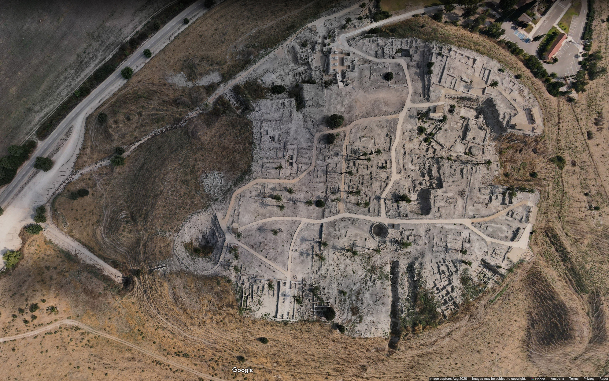
Tel Megiddo, also known as Tell el-Mutesellim, from above.
Photo: İevgen Bunevych, August 2020
Source: Google Maps
_________________
The morning of the battle
On the morning of the battle, the twenty first day of the first month of the third season (May 15, 1479 BC), the signal for the commencement of hostilities seems to have been the appearance of the king from the royal tent. At once the order was issued, as the Annals has it, 'to the entire army to cross the valley of the Kina' As the Egyptian camp most certainly stood on the south of the Kina on the flat land between the brook and the hills D and E, the words lost in the lacuna must have referred to the depression through which the brook flowed. There is no other feature of the topography of which the word 'cross' could well be used.
It seems safe, therefore, to proceed on the assumption that the royal command was to cross the Kina. That the words 'entire army' are to be taken literally is impossible, if we are to accept the statement that the south wing of the Egyptian force was later at the 'hill south of Kina'. The lacuna in this instance must also have included some phrase applicable to the valley of the Kina. If the entire army had crossed the brook, the south wing could not well be said to be at the hill south of the brook, for the channel that the stream has cut is so marked a feature of the topography that we may be sure it, rather than the hill south of it, would have been mentioned had the brook intervened between the Egyptian south wing and the hill. When the Annalist speaks of the 'entire army', he probably uses it in a loose sense to designate the large majority of the troops, including, as we shall see, the centre and the north wing. Only on this interpretation of the words 'the entire army' is is possible to reconcile these conflicting statements.
In order to reach the north bank of the Kina, the Egyptian force would have to cross the stream at or near the point 'a' at the opening of the Wady es-Sitt on Map III. This would have been necessitated by the depth of the channel that the stream has cut across the flat cultivated land. As has already been pointed out, this channel is some fifteen or twenty feet deep at 'b', while at 'a' it is only two or three feet deep.
As there was a body of Egyptian chariotry with the centre of the army, it would be necessary for them to find some point at which the crossing could be easily made, and such a point is found anywhere along the course of the stream south of 'a'. That all the chariots in the Egyptian ranks were with that portion of the army north of the Kina is certain, for the banks of the stream between 'b' and the place where the brook crosses the Taanach road at "c" are so steep, in places being practically perpendicular, as to preclude all idea of chariots crossing the stream between those points, especially in the face of an enemy, as would have been necessary had the chariots advanced towards the city from the south of the Kina.
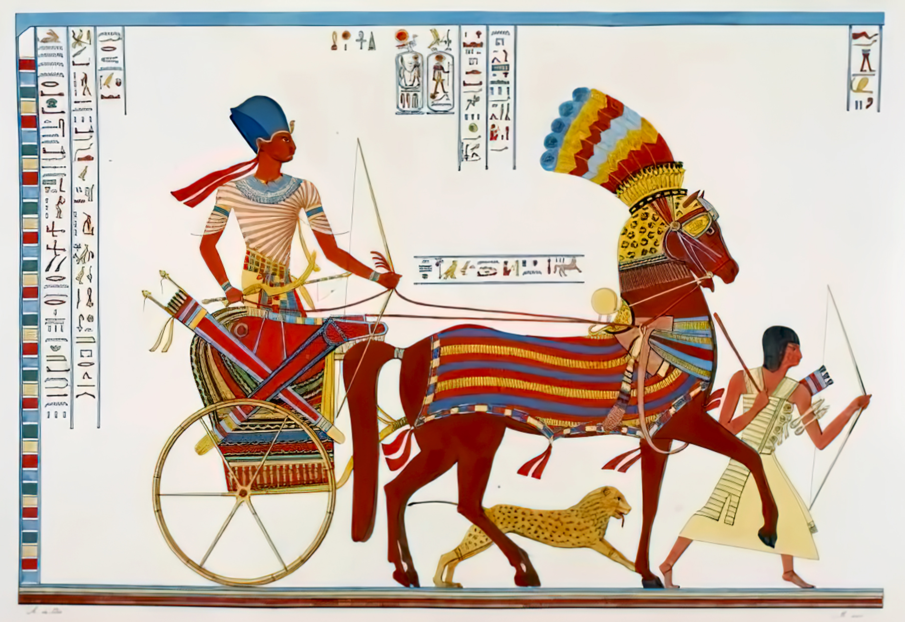
Egyptian War Chariot, bearing Pharaoh Ramses II triumphant, wearing the Blue Crown of War.
Painting: Carlo Lasinio (Engraver), 1832 - 1844
Permission: Public Domain
As the Egyptians were the attacking force, their formation and position would necessarily be determined to a great extent by the location and disposition of the Asiatic army. It will therefore be necessary to consider the position of the Allies before proceeding further with the discussion of the Egyptian lines of battle. With their camp pitched on mound G there would be but one formation natural for the Allies to assume. It is hardly conceivable that they would have foregone the advantage to be derived from the elevated position of the mounds. We must suppose that their lines were drawn up around the edge of mounds G, H, and I.
By this formation they would have had the natural defence against the onslaught of the Egyptians that the sloping sides of the mounds afforded and, in the case of the south wing, the channel of the Kina also. That there was a strong body of chariots with the Allies is certain, not only from the fact that the chariot as an instrument of warfare was in use in Asia before it was known in Egypt, but also from the fact that among the spoil taken from Megiddo after the battle were 924 chariots and 2 238 horses of all kinds. We need not suppose that all of them were present in the battle.
Undoubtedly many of them were taken during the course of the later siege and some may have come from surrounding towns, the spoil from which has apparently been included in that from Megiddo in the lists of booty. This is by far the largest number of chariots recorded as having been taken in any battle during Thutmose's campaigns.
The only other three instances in which the numbers have survived give us 13 chariots from I-n-r-t on the seventh campaign, 15 from the district of Nuges on the ninth campaign, and 60 from I-r-y-n and Naharin on the tenth campaign. But as in other respects the numbers in the lists of booty from Megiddo are far in excess of those recording the spoil from the later campaigns, we must suppose that the forces put into the field by the Allies at Megiddo were larger than the Egyptians encountered in any of the subsequent campaigns where they were dealing with more or less isolated states instead of with a wide spread and powerful coalition.
As has already been said, it is not probable that all the chariots and horses which figure in the lists of booty from Megiddo were actually present in this battle. There must have been a sufficient number present, however, to have constituted a considerable portion of the Asiatic strength. It is necessary, therefore, in determining the position of the allied troops to take this body of chariots into consideration. If we are right in placing the Egyptian lines in a semicircle along the strip of cultivated land between the foothills and the mounds on which the Asiatics were camped, that consideration alone would lead us to conclude that the enemy was drawn up in roughly similar formation opposite them. When we examine the topography of the battlefield, we see at once that such a formation is exactly that which an army occupying the mounds G and H, and possibly I, would be likely to assume. By arranging their lines along the top of the slopes on the west and south of the mounds G, H and I, the Asiatics would be able to secure what advantage was to be derived from forcing their opponents to attack them while charging up hill.
Moreover, should they themselves charge forward against the Egyptians, they would have the advantage of advancing down hill, as did the Greeks at Marathon. If we consider it likely that the Allies would thus accommodate themselves to the topography of the country, there can then be only one location where they could conceivably have placed their chariotry. The northern part of the western slope of mound G is too steep to allow chariots to descend with any assurance that they would arrive at the bottom of the incline in an upright position. The same is true of the south and east side of mound H.
However, between the northwest side of mound G and the south side of mound H the descent from the mounds to the cultivated land below is quite gradual, allowing a space about half a mile long down which chariots could advance with ease. It is at this point in the Asiatic lines, therefore, that we must locate their chariotry. It is there also, in the centre of their force, that we would naturally expect them to mass their greatest strength, opposite the portion of the Egyptian army that Thutmose himself led in person.
With the Allies thus disposed, the location of the Egyptians becomes fairly certain. The north wing, which was to the north west of Megiddo, was drawn up along the foot of the hill A with a portion of the Asiatic foot opposite it on the side of the mound G. The Egyptian centre, probably composed largely of chariots, took up its position along the foot of the hills B and C opposite the Asiatic centre, which was on the western edge of the mound H. Then the Egyptian south wing, where only foot soldiers were practicable, probably held the ground occupied on the preceding evening by Thutmose's camp, the southern extremity of the wing resting on the knoll F.
When once the battle was joined, the chariots would charge at full speed upon the opposing ranks. At the word of command, therefore, we may suppose that the Egyptians advanced upon the mounds G, H and I from the west and south. Direct advance upon the south of mound H would be very difficult, as the banks of the Kina and the slope of the mound is steep at that point. We may therefore suppose that the Asiatics left only a small force to hold this position and placed their south wing on mound I, one extremity of the line being protected by the steep side of mound H and the other by the channel of the Kina.
If the south wing of the Egyptians was composed of infantry, it would be possible for them to cross the Kina to the attack of the Asiatic south wing. When once this wing had been broken, the Egyptians could then attack the Asiatic main body in the rear with telling effect. It is possible that some such movement, rapidly executed, won the day for the Pharaoh.
_________________
The actual battle
Of the actual conflict which took place there is not a vestige of information. To judge from the Annalist's narrative it would seem that the Asiatics fled without striking a blow.
'Then his Majesty prevailed against them at the head of his troops; and when they saw that his Majesty prevailed against them, they fled headlong to Megiddo with faces of fear. They abandoned their horses and their chariots of gold and of silver. They drew them up by hoisting with their garments into this city, for the people had shut up the city against them, and they let down garments to hoist them upwards into the city.'
That the Allies held their ground for any great length of time seems unlikely, if we are to trust the statement of the number of hands cut from the dead, only 83 being recorded among the spoil from Megiddo. Although this figure may not represent the exact number of the slain, it is evident that the Asiatics fled after offering very little resistance. Why they did so is not plain. They probably mustered a considerable force and they certainly had the advantage of position.
It is likely, however, that they had been hastily gathered together, many undoubtedly having been forced into the coalition against their will, as was sometimes the case among the Syro-Palestinian allies in the later period of the Assyrian invasions. It is possible that the Egyptian force proved to be larger than the Asiatics had expected to encounter. Moreover, the seat of the rebellion was in the north, and many of the Allies must have felt themselves far away from their home land and have lost interest in the conflict as they advanced towards the south.
Perhaps the fact that the Pharaoh had out-manoeuvred them would have upset any previously laid plans of the Allies. Whatever may have been the reason, the Asiatics fell back before the Egyptian advance and their rout was immediately complete.
The situation at the Battle of Megiddo was not unlike that which subsequently developed in the course of the action at Kadesh between Ramses II and the Hittites. In the latter case the Egyptian camp lay along the bank of the Orontes and the Hittites, in attacking the camp, threw out their wings to either side and inclosed the Egyptian army, driving it back towards the river.
In the battle of Megiddo the Egyptian army threw out its wings and enclosed the Asiatic army, driving it back through its camp to the city of Megiddo behind. At Kadesh the utter destruction of the Egyptian force was prevented by the fact that the Hittites stopped to plunder the Egyptian camp. The same event in the battle of Megiddo prevented the total destruction of the Allies. As Thutmose's army closed in on the Asiatic forces, the Egyptians in pursuing the fleeing foe, found it necessary to pass through the enemy's camp, and the rich plunder that lay everywhere around proved too much for their discipline.
_________________
An opportunity lost
Forgetting the routed Asiatics, the Pharaoh's army set to looting the captured camp, thus affording the enemy the opportunity to effect their entrance into Megiddo or to flee to the north across the plain of Esdraelon. What might, therefore, have proved the total annihilation of the Asiatics, was turned into a mere defeat, though a severe one, and Thutmose found that the cupidity of his troops was to cost him still further efforts.
When the Asiatics turned to flee before the Egyptian onset, they found themselves confronted with a most dangerous situation. The inhabitants of the city, who must have been intently watching the struggle from the top of the wall, when once the magnitude of the disaster which had befallen their arms became apparent, lost all thought for the safety of the survivors and shut the gates of Megiddo in the faces of their troops fleeing to the city for safety. Few, if any, of the chariots of the Allies were saved. Had the conflict taken place in the open plain, many of the Asiatics could have made use of their chariots in effecting their escape across the plain.
That, however, was impossible in the situation in which they found themselves. On the west, south, and southwest were the advancing Egyptians, while to the north lay the city, its gates shut against friend and foe alike. Escape, except over the city wall, was possible only to the northeast, and to flee in that direction it was necessary for them to cross their camp and descend the steep sides of the mound G on the northeast, a decline too precipitate for horse and chariot, even had they been able to make their way through the debris scattered about the camp. As a result of this unforseen situation, the Asiatics
'abandoned their horses and their chariots of gold and of silver'
and took to their heels for safety. This fact probably accounts for the large number of horses and chariots mentioned above as enumerated among the spoils of Megiddo. Many of the Allies must have escaped northward into the plain of Esdraelon and beyond, especially when they found the city gates closed against them.
When once they had reached the plain, they would have been safe, for the Egyptians, as we saw, had abandoned the pursuit for the lure of plunder. Those who turned towards the city, among which number were the kings of Kadesh and Megiddo, were drawn up into the city by the inhabitants. The glacis, extending along the base of the wall, allowed the fugitives to get near enough to the top of the wall so that the inhabitants, by lowering the long girdles from their waists, could pull them up to the top. The Egyptian sense of humour is evident in the relish with which the Annalist describes the undignified escape of the kings, dangling at the ends of the lowered garments.
Had the Egyptians pursued the Asiatics, they would undoubtedly have been able to inflict great loss upon the mass of disorganised fugitives, struggling for an opportunity to climb into the city. The absorption of the victors in the plundering of the camp could not be better illustrated than by the fact that the enemy were allowed the time necessary to effect their escape in this cumbersome fashion. It is likely that the royal fugitives did not long remain within the walls, for when Megiddo finally surrendered after a siege, they were not among the prisoners. Probably seeing the hopelessness of the situation, they lingered in the city only long enough to gather a few followers, and then escaped by the northern gate, still surviving, just above the terrace-like projection on the north of the Tell.
Meanwhile the Egyptian army was gathering in a rich harvest of spoil. Besides the chariots already spoken of, the hands cut from the bodies of the few Asiatics who had fallen in battle, totalling only 83, were gathered together as evidence of victory. Many of the enemy must have been made captive in the confusion of the rout and these too counted as spoil.
One of the most conspicuous prizes, however, was the tent of the king of Kadesh, a sumptuous affair, supported by seven poles and worked, probably, with silver. It undoubtedly contained handsome furniture, a prize for that time as notable as was, at a later day, the famous tent of Darius captured by Alexander the Great. All this booty seems to have been gathered together before the king. A large share of the spoil was made over to the treasury of Amon. Much must have gone to replenish the royal coffers. Some of it undoubtedly was given as rewards to those members of the army who had distinguished themselves in the engagement.
At this point an interesting supplement to the Annals is furnished by the biography of Amenemheb, one of Thutmose's generals, who accompanied the king on many of his campaigns, though whether he was present at Megiddo is uncertain. In relating his part in Thutmose's campaigns in Syria, he says :
When his Majesty came to Nahirin, I brought off three men from the fight there; I set them before thy Majesty as living prisoners. Again I fought on that expedition in the land of Carchemish. I brought off...as living prisoners. I set them before mv lord. He rewarded me with a great reward.
Again I beheld his victory in the country of Takhsi, the wretched, in the city of Mero ... I brought off Asiatics, 3 men, as living prisoners.
Then my lord gave to me the gold of honour; list thereof: 2 flies, a lion, a female slave and a male slave.
Then my lord gave to me the gold of honour ......
Eighteenth Dynasty: 1 550 BC - 1 292 BC
Mentechenu
Around his neck, Mentechenu, an official from the time of Amenhotep II, wears around his neck two chains of golden rings, the so-called ' gold of bravery ' or ' gold of honour '
Photo: Don Hitchcock 2018
Source: Original, Staatliche Museen zu Berlin, Neues Museum, Germany
Text: © Card at the Staatliche Museen zu Berlin (CC BY-NC-SA 3.0 DE)
Then my lord gave to me ...... 2 flies......
At this time, Pharaohs awarded golden fly amulets or golden fly necklaces to soldiers who had distinguished themselves by bravery and persistence in the face of enemies, as part of the Order of Valour. The fly symbolised courage and tenacity.
Eighteenth Dynasty: 1 550 BC - 1 292 BC
Necklaces
The fly-shaped beads on the necklace symbolises courage and tenacity. They are given to soldiers as an award.
Catalog: Gold, glass; location unknown, circa 1 500 - 1 300 BC.
Photo: Don Hitchcock 2014
Source and text: Original, Rijksmuseum van Oudheden, National Museum of Antiquities, Leiden
The larger objects of spoil were thus brought up before the king, who undoubtedly indicated the share belonging to Amon, that designed for the royal treasury, and that to be divided among the army. In the days of Ahmose I it was the duty of the royal herald to present to the sovereign those of his commanders who had a claim on the royal favour because of conspicuous valour. We may picture to ourselves a scene of barbaric splendour as the Pharaoh sat enthroned upon the battlefield, surrounded by his officers and troops, while Intef, the herald, brought before the king, one by one, the candidates for the sovereign's rewards.
And much of the praise that the army is said to have given to the king probably arose from the acclamations of the soldiery as to one after another of their favourite officers Thutmose distributed the marks of his favour.
We cannot suppose, however, that much time was consumed in this way. Thutmose realised that his work was only half done while Megiddo itself remained in the enemy's hands. He therefore urged on his army to continue the successful efforts they had begun, adding:
'Behold, every land is given to my Majesty according to the command of Re this day; for every chief of every northern country which has revolted is within it; for it is the capture of a thousand cities, the capture of Megiddo. '
But apparently the great opportunity had been lost. The delay occasioned by the plundering of the camp had been sufficient to allow the leaders of the Allies to escape, and when finally the city fell, 'every chief of every northern country' was no longer within it.
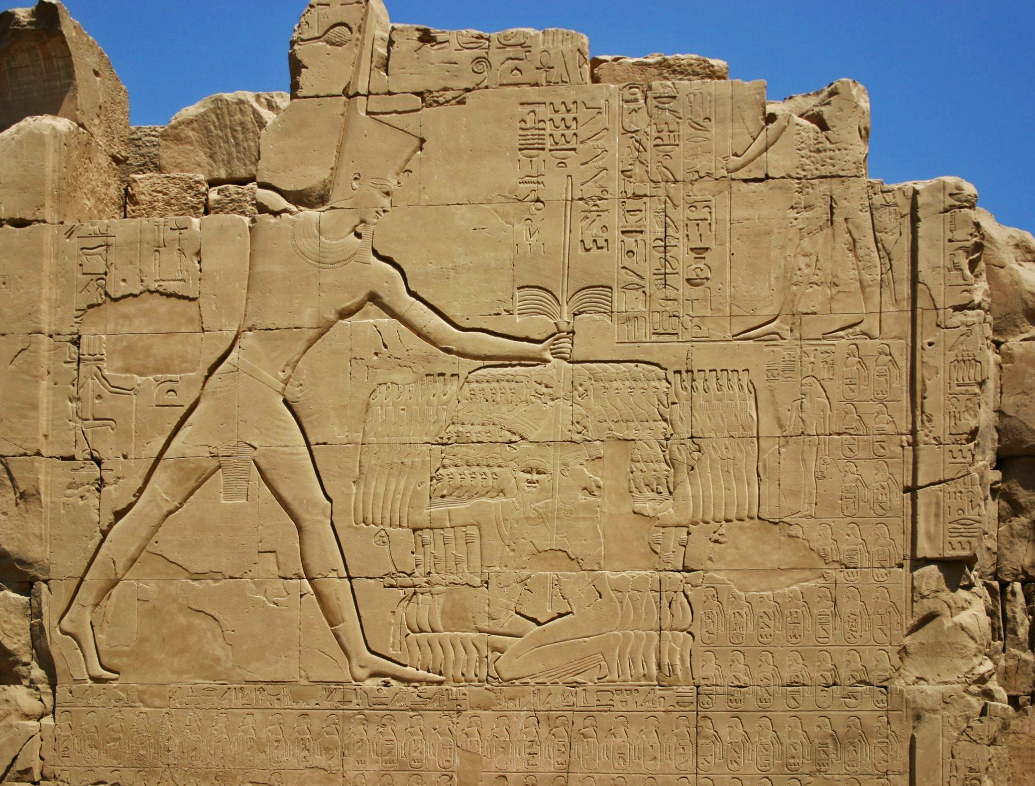
Eighteenth Dynasty: 1 550 BC - 1 292 BC
King Thutmose III
Thutmose III smiting Canaanite enemies on the seventh pylon at Karnak describing the Battle of Megiddo, 15th Century BC.
The Karnak Temple on the east bank fo the Nile River at Thebes covers an area of more than 100 hectares.
Photo: Markh
Permission: Public Domain.
Proximal source: Wikipedia
_________________
The Siege of Megiddo
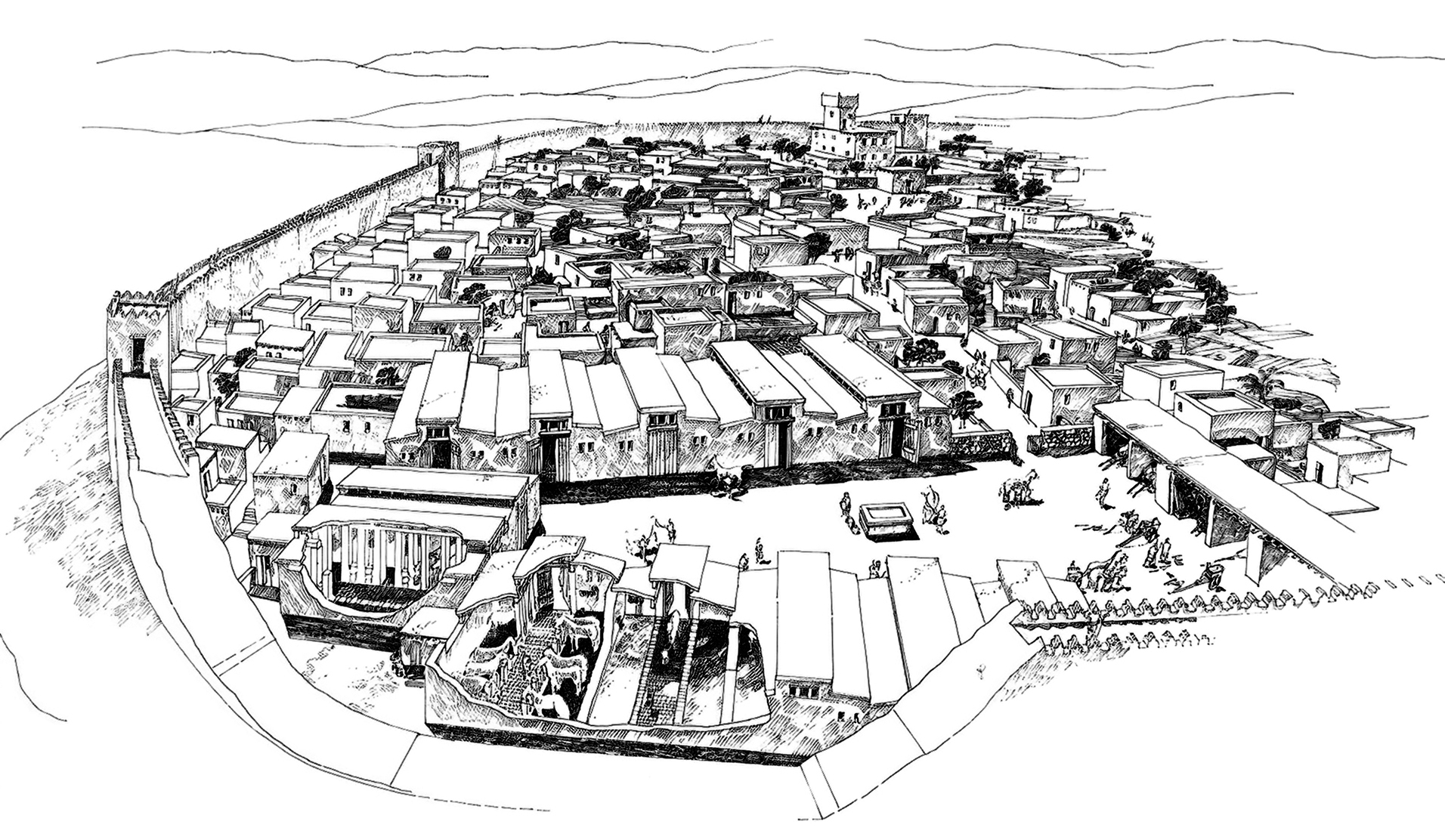
Megiddo
Artist: unknown
Proximal source: https://emp.byui.edu/satterfieldb/ancient%20israel/megiddo.html
The Annals, lines 90 - 98
Behold, officers of the mnft hastened, to ensure that every man should know his position. They measured this city, enclosing it with an earthwork, fenced about with the green wood of all their pleasant trees, while his Majesty himself was upon the fortress, south of this city, watching upon it day and night, enclosed with a thick wall. The name was called "Menkheperre-is-the-ensnarer-of-the-Asiatics".
Soldiers were appointed to watch at the tent of his Majesty, who were ordered Steadfast! Steadfast! Watchful! Watchful! Now everything that his Majesty did to this city and to this wretched enemy together with his wretched army was recorded on the day by its name, by the name of the voyage, by the name of the officers of the mnft .... They were recorded upon a roll of leather in the temple of Amon on this day.
Now the chiefs of this country came upon their bellies to kiss the earth because of the might of his Majesty; to beg the breath for their nostrils, because great was his power and because great was the might of Amon over every foreign country. All the chiefs were brought because of the might of his Majesty, bearing their tribute of silver, gold, lapis-lazuli, malachite, and carrying in clean grain, wine, cattle, small cattle, for the army of his Majesty.
One gang of them was bearing tribute southward. Then his Majesty appointed anew the chiefs of every city ....... Megiddo: 340 living captives, 83 hands, 2 041 mares, 191 female colts, 6 stallions, .... male colts, 1 chariot worked with gold, its pole of gold, belonging to that foe; one beautiful chariot wrought with gold belonging to the chief of Megiddo ........ 892 chariots of his wretched army: total 924. 1 beautiful bronze suit of armour of that foe; one beautiful bronze suit of armour of the chief of Megiddo; 200 suits of armour of his wretched army, 502 bows, 7 poles of mrw (cedar) wood wrought with silver of the tent of that foe.
Now the army of his Majesty seized .... 387....1 929 cattle, 2 000 small cattle, 20 500 small white cattle.
Apparently no effort was made to take the city by storm. Just why Thutmose did not make such an attempt at once is hard to surmise. We know from the results of the excavations at Megiddo that the place was strongly fortified, but brick walls, even of the strongest, were no deterrent to the king on his later campaigns when he breached the walls of Kadesh, a much more formidable fortress than Megiddo. It is possible that he realised what was apparently the real situation in the city, namely, that no preparation had been made to resist a long siege, and he may therefore have decided to let hunger fight for him, rather than risk the chance of a repulse if he attempted to take the place by storm. He therefore issued the necessary orders and the preparations for the siege began.
The details of the methods pursued by the Egyptians in the siege are, like the details of the battle, very obscure. The Annals state that
they measured this city, enclosing it with an earthwork, fenced about with the green wood of all their pleasant trees, while his Majesty himself was upon the fortress east of the city, watching upon it day and night ....... enclosed with a thick wall with its thick wall. Its name was called, 'Menkheperre-is-the-ensnarer-of-the-Asiatics'. It was not permitted that one of them go out to the outside upon the back of this wall except to go out to knock at the door of their enclosure.'
In the account of the feasts and offerings instituted by the king on his return from this campaign, Thutmose says that he made these offerings 'when my Majesty returned from the land of Retenu on the occasion of the first victories which my father Amon gave to me in his giving to me every land of Zahi, assembled and shut up in one city, I ensnared them in one city. I built upon them with a thick wall to .... of the breath of life, by the favour of my father Amon.'
Another fragment containing an account of the first campaign preserves the meagre statement:
'Majesty surrounded it with a wall, made thick ...... Not did they breathe the breath of life, being surrounded in front of their wall.'
Before making any suggestions in regard to the method pursued by the Egyptians in constructing this wall, I should like to quote a passage from Thucydides' account of the siege of Plataea by the Peloponnesians. The narrative runs:
'In the first place the soldiers felled the fruit-trees and surrounded the city with a stockade, that henceforth no one might get out. 'They then began to raise a mound against it, thinking that with so large an army at work this would be the speediest way of taking the place. So they cut timber from Cythaeron and built on either side of the intended mound a frame of logs placed crosswise in order that the material might not scatter. Thither they carried wood, stones, earth and anything which would fill up the vacant space. ..... The Peloponnesians, having failed in this, as in their former attempt, surrounded Plataea with a wall. Trenches out of which they took clay for the bricks were formed both on the inner and outer side of the wall.'
Taking this passage from Thucydides in conjunction with the account in the Annals it would seem most likely that Thutmose first marked out, or 'measured', a line of circumvallation (defensive wall) along which earth works were to be thrown up. It is possible that the timbers used in 'fencing-in' the city were employed, as at Plataea, to strengthen the earthworks, forming a sort of framework in which to pack the earth and stones.
The trees may, on the other hand, have been used, as Maspero suggests, to form a sort of stockade or palisade, which could be easily and quickly erected to assist in shutting up the city until the heavier rampart of earth could be thrown up. Earthworks about two miles long would effectively inclose the Tell. At least one tower or bastion was raised upon the wall, though it is not at all unlikely that such towers were located at intervals along the entire line of siegeworks. The one tower mentioned in the Annals stood on the east of the city. Here the king made his headquarters, directing the troops from this advantageous position where the widest outlook over the operations could be secured.
This method of conducting a siege by walling in a town was in use throughout antiquity. An interesting parallel is recorded on the north-Syrian stela of Zakir, king of Hamath, dating from the eighth century BC. Zakir relates how Bar-Hadad, son of Hazael, king of Aram, assembled seven kings against him:
'All these kings erected entrenchments against Hazrak. They threw up a wall higher than the wall of Hazrak and excavated a moat deeper than its moat. The rampart that Thutmose erected around Megiddo could hardly have been as high as the walls of the city except on the south, owing to the fact that the city stood on a natural elevation from the base of which the land slopes away on the west, north and east. Moreover, as the Egyptians do not seem to have done more than starve the city into submission, it was not necessary to raise the ramparts high enough to overlook the city.
The sources omit all mention of any encounter between the Egyptians and the Asiatics during the siege. That such conflicts occurred we may feel certain, and in the biography of Amenemheb we have a suggestion of the many stirring events, the details of the story that the Annals give only in outline. As the siege progressed, the supplies in the city ran short.
Megiddo was well supplied with water, to be sure, from Ein el-Kubbi at the northern base of the Tell ( mound on which the city was built - Don ) Schumacher has demonstrated that this spring is an artificial source, the water being brought down in an underground channel from 'Ain es-Sitt. It is also highly probable that there existed some connection with this channel within the city itself as the excavations at other Palestinian sites have shown to have been customary.
It was lack of food rather than of water that probably caused the surrender of the city. The Annals state that the Egyptians did not allow any of the Asiatics to
'go out to the outside upon the back of this wall except to go out to knock(?) at the door of their enclosure.'
This statement can only mean that none of the inhabitants of Megiddo were allowed to leave the city unless they came out to surrender to the Egyptians. In this way the siege continued until famine, most probably, forced the inhabitants to surrender.
The siege had begun on May 15th. The next date in the campaign that we are able to fix is not later than October 11th, at which time Thutmose was in Thebes celebrating a feast of victory. In the interval occurred the siege, a march to southern Lebanon where three cities were captured and a fortress of some kind was constructed, and the return to Egypt. The operations subsequent to the fall of Megiddo could not well have been carried out in less than three months and probably consumed even more time. If, as seems evident, Megiddo was unprepared for a siege, a month would be ample for the interval between the commencement of the work on the enclosing rampart and the surrender of the place.
But this again, like so much connected with the battle, is at best conjecture. The fall of the city carried with it the submission of the other towns and villages in the region around Megiddo. Being the most commanding fortress between Jezreel and the coast, it must have exercised control over an extensive territory, the inhabitants of which naturally looked to Megiddo as their protector and their place of refuge in time of danger.
It is not at all unlikely that the leisurely march of the Egyptians from Gaza to Yemma had seen the submission of many of the towns and strongholds in the south. If they had joined in the revolt the decision of the Allies to make their stand at Megiddo must have left the state to the south defenceless before the Egyptian advance.
With the fall of Megiddo the towns in northern Palestine would undoubtedly have seen the uselessness of further resistance and would have hastened to make their submission. The Annals tell us that
'The chiefs of the country were coming upon their bellies to kiss the earth because of the might of his Majesty, to crave breath for their nostrils, because great was his power and because great was the might of Amon over every country. All the chiefs were brought because of the might of his Majesty, bearing their tribute.'
The importance of the fall of Megiddo cannot be overestimated. It crushed once for all the rebellion in the south. In the subsequent campaigns we have no reference to any serious trouble south of the district of Nuges and southern Lebanon. This overwhelming defeat of the Allies just at the beginning of their rebellion served largely to break up the alliance, and the later campaigns of Thutmose were almost entirely against a succession of isolated powers.
Only in the extreme north, in Naharin and the Orontes valley, was any united effort made to stem the tide of Egyptian advance. A coalition of all Syria-Palestine was made impossible by the crushing blow that the Allies had received at the very beginning of the movement. It gave the Pharaoh the prestige gained from success in the initial battle of the war, and to a great extent paved the way for his subsequent victories in the north. Since the fall of Sharuhen, after a three years' siege by Ahmose I a century earlier, it was the most important single step towards the final conquest of the country by Egypt. It was a fitting introduction to the wars of the greatest conqueror the world had then seen.
That it made a lasting impression on the people of the time is evident from the many references to the battle as well as from the fact that the Annals devote almost as much space to this first campaign as to all the succeeding ones put together. It is the first battle in history in which we can in any measure study the disposition of troops and as such forms the starting point for the history of military science.
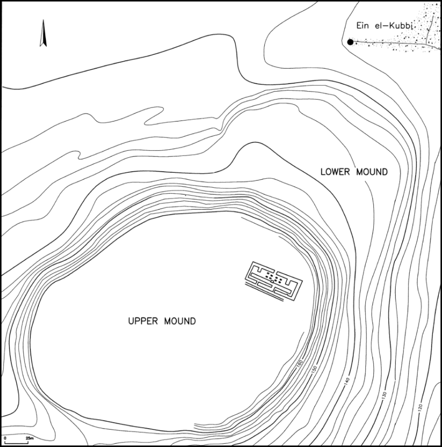
Position of the spring of Ein el-Kubbi (or 'Ain el-Kubbi), well outside the walls of the original town.
Shumacher (1908) writes:
In November, 1904, I had a trench dug in the area of the 'Ain el-Kubbi, at the northeastern foot of the tell terrace, just beside the main road from Jenin to Haifa. The spring was covered with rush vegetation and had become marshy and it was hoped that the trench would make better drainage possible, thus providing purer and healthier drinking water for the workers. Our goal was only partially reached: For us Europeans the spring water remained unpotable due to its hard, unpleasant taste and its animal admixtures.
Our excavations, however, confirmed the statement of the natives that the 'Ain el-Kubbi (141.22 m) was fed by a conduit, which they claimed originated in the 'Ain es-Sitt (157.00 m) on the southwestern slope of the Dahr ed-Dar in the area of el-Lajjun. Unfortunately we could not prove the existence of the connecting conduit between the two springs as they are situated a distance of 1600 m from each other as the crow flies.
But we discovered a 20-m-long rock-cut channel in the spring cave of the Ein es-Sitt, running in northeasterly direction—towards the 'Ain el-Kubbi. Next to the 'Ain el-Kubbi we also found a walled channel, running towards the centre of Tell el-Mutesellim. Since both springs had the same kind of small fish, not more than 0.04 m long, I assume that the two springs, at the two different levels, were both fed from the same subterranean basin. I believe that this basin would be situated 300 m west of the Roman theatre, under the present watershed. In antiquity the inhabitants of Tell el-Mutesellim might have dug wells into the mound, using the conduit of the 'Ain el-Kubbi as a water source. We have not yet discovered such wells on the tell, but their existence is evidenced by the fact that water cisterns were completely missing in the ancient tell strata.
Source for map: Finkelstein, Ussishkin (2006)
Text: Shumacher (1908)

Topographic map of the larger region around Tell el-musellim, showing the position of Ein el-Kubbi, (or 'ain el-Kubbi) and noting the fact that the crossroads was placed right at the spring, for the convenience of travellers.
Click on the map to get the full size map, without additions.
Source: Shumacher (1908)

Topographic map of Tell el-musellim.
Source: Shumacher (1908)
References
- Adams B., Porat N. , 1996: Imported Pottery with Potmarks from Abydos, In: J. Spencer (ed.), Aspects of Early Egypt, London: British Museum Press, p. 98-107.
- Anderson W. , 1989: Badarian Burials: Possible Indicators of Social Inequality in Middle Egypt During the Fifth Millennium B.C., Department of Anthropology McGill University, Montreal April, 1989, a thesis submitted to the Faculty of Graduate Studies and Research in partial fulfilment of the requirements for the degree of Master of Arts
- Böhme I. , 2013: Die privaten Sarkophage des Neuen Reiches – ein Vorbericht, Göttinger Orientforschungen IV Ägypten 54, DAI Kairo - German Archaeological Institute Cairo, preliminary paper for a PhD thesis.
- Borchardt L. , 1911: Altagyptische Sonnenuhren, Zeitschrift fur ägyptische Sprache, 48 (1911), Tafel 2
- Breasted J. , 1903: Jewellery from the Tombs of Egypt, The Biblical World, Vol. 22, No. 1 (Jul., 1903), pp. 64-66, published by The University of Chicago Press, http://www.jstor.org/stable/3140533.
- Brunton G., Caton-Thompson C., 1928: The Badarian civilization and predynastic remains near Badari, (British School of Archaeology in Egypt and Egyptian research account : thirtieth year, 1924). 1928
- Brunton G., Morant G., 1937: Mostagedda and the Tasian Culture, British Museum Expedition to Middle Egypt, First and Second Years (1928, 1929), B. Quaritch Limited, 1937 - Egypt - 163 pages
- Caton-Thompson E., Gardner E., 1934: The Desert Fayum, Royal Anthropological Institute of Great Britain and Ireland, London, 1934.
- Cowie S., Johnson T., 2001: The Mummy in Fact, Fiction and Film, McFarland, 3 Dec. 2001 - Performing Arts - 208 pages
- Cramer M., 1936: Zeitschrift für Ägyptische Sprache und Altertumskunde, Volume 72, 1936. pp. 100ff. u. Tf. IX, 1, 2.
- David R., 2002: The Experience of Ancient Egypt, Rutledge, 9 Sep. 2002 - Social Science - 216 pages
- Davies B., 1999: Who's who at Deir el-Medina : a Prosopographic Study of the Royal Workmen's Community, Leiden : Nederlands Instituut voor Het Nabije Oosten, 1999
- Davies Norman de Garis, 1925: The Tomb of Two Sculptors at Thebes, The Metropolitan Museum of Art, Robb de Peyster Tytus Memorial Series Volume IV.
- Dodson A., Hilton D., 2004: The Complete Royal Families of Ancient Egypt, The American University in Cairo Press, London 2004
- Erman A., 1894: Life in Ancient Egypt, Courier Corporation, 1894 - History - 570 pages
- Erman A., 1927: The literature of the ancient Egyptians; poems, narratives, and manuals of instruction, from the third and second millennia BC, London, Methuen & co. ltd., pp. 67f.
- Ertman E., 2013: Gesichtseinlage von König Echnaton / Amenophis IV. aus opak-blauem Glas, Auszug und Übersetzung aus Journal of Glass Studies 2013-55, S. 13-19
- Escolano-Poveda M., 2019: Egypt’s Pharaohs welcomed summer with this fabulous festival, 20/03/20. Retrieved from: https://www.nationalgeographic.com/history/magazine/2019/05-06/ancient-egypt-royal-feast/
- Finkelstein I., , Ussishkin D. 2006: Two notes on early bronze age Megiddo, in I will speak of the riddle of ancient times ed. Maeir A. and P. de Miroschedji
- García J., 2013: Ancient Egyptian Administration, BRILL, 7 Jun. 2013 - Reference - 1112 pages
- Gatto M., 2001-2002: Two Predynastic pottery caches at Bir Sahara (Egyptian Western Desert), Sahara, 13: 51 - 60
- Gressmann H., 1909: Altorientalische Texte und Bilder zum Alten Testamente, Tübingen, J.C.B. Mohr.
- Habicht M., 2014: Semenchkare - Phantom-König von Achet-Aton: Beitrag zur Erforschung der rätselhaften Nachfolge von Echnaton,epubli, 17 Feb 2014 - Science - 96 pages
- Harer W., 1985: Pharmacological and Biological Properties of the Egyptian Lotus, Journal of the American Research Center in Egypt, Vol. 22 (1985), pp. 49-54 Published by: American Research Center in Egypt DOI: 10.2307/40000390
- Hartwig M., 2006: A Companion to Ancient Egyptian Art, John Wiley & Sons, 23 Dec. 2014 - Literary Criticism - 624 pages
- Hodel-Hoenes S., 2006: Life and Death in Ancient Egypt: Scenes from Private Tombs in New Kingdom Thebes, Cornell University Press, 2000 - Art - 329 pages
- Holmes D., 1989: The Predynastic Lithic Industries of Upper Egypt: A Comparative Study of the Lithic Traditions of Badari, Nagada and Hierakonpolis, BAR (15) 469, Volumes I and II.
- Humphreys C., Waddington G., 2017: Solar eclipse of 1207 BC helps to date pharaohs, Astronomy & Geophysics, Volume 58, Issue 5, 1 October 2017, Pages 5.39–5.42, https://doi.org/10.1093/astrogeo/atx178, Published: 01 October 2017
- Jung M., 2012a: F. Seyfried (eds.), In the Light of Amarna. 100 years of the discovery of the Nefertiti, Berlin 2012, p. 206 (cat. No. 7).
- Jung M., 2012b: in: F. Seyfried (Hrsg.), Im Licht von Amarna. 100 Jahre Fund der Nofretete, Berlin 2012, p. 332
- Kákosy L., 1995: 'The Soter Tomb in Thebes', in S.P, Vleeming (ed.), Hundred-Gated Thebes: Acts of a Colloqium on Thebes and the Theban area in the Graeco-Roman Period, Leiden: Brill, 61- 67
- Kayser H., 1969: Ägyptisches Kunsthandwerk: ein Handbuch für Sammler und Liebhaber, Braunschweig, Klinkhardt & Biermann, 1969
- Kitchen K., 1993: Ramesside inscriptions : translated and annotated Notes and comments, 1, Ramesses I, Sethos I and contemporaries (Oxford, 1993), 2-3.
- Loret V., 1889: La Tombe de Khâ-M-Hâ, in: Gaston Maspero, in: Urbain Bouriant - Victor Loret - H. Dulac (editors), Mémoires publiés par les membres de la mission archéologique française au Caire, Tome premierFasc. 1, Paris 1889, plate 1 after page 114
- Malkowski E., 2010: Before the Pharaohs: Egypt's Mysterious Prehistory, Inner Traditions / Bear & Co, Apr 12, 2010 - History - 336 pages
- Martin G., 1991: Hidden Tombs of Memphis, Thames and Hudson, London 1991
- Maspero G., 1903: History of Egypt, Chaldea, Syria, Babylonia, and Assyria, London : Grolier Society
- Math N., 2014: Die Badarikultur, Neue Untersuchungen zu einer Kultur des 5. Jahrtausends v. Chr., angestrebter akademischer Grad Master of Arts (MA) Wien, 2014
- McKerrel H., Tylecote R., 1972: The working of copper-arsenic alloys in the Early Bronze Age and the effect on the determination of provenance, Proceedings of the Prehistoric Society, 38, pp. 209–218. doi: 10.1017/S0079497X00012111.
- Mettlen J., 2012: in: F. Seyfried (Hrsg.), Im Licht von Amarna. 100 Jahre Fund der Nofretete, Berlin 2012, p. 344 (cat. No. 126).
- Meyer-Dietrich E., 2017: Auditive Räume des alten Ägypten: Die Umgestaltung einer Hörkultur in der Amarnazeit, Brill, 9 Nov. 2017, pp. 1128.
- Nelson H., 1913: The Battle of Megiddo, Dissertation for a PhD, University of Chicago
- O'Connor D., Cline E., 2001: Amenhotep III: Perspectives on His Reign, University of Michigan Press, 2001 - History - 393 pages
- Patch D., Eaton-Krauss M., Allen S., 2011: Dawn of Egyptian Art, Jan 1, 2011 - Art, Ancient - 275 pages
- Pommerening, T., Marinova, E., Hendrickx, S., 2010: The Early Dynastic origin of the water-lily motif, Chronique d'Egypte, 85 (2010): 14-40
- Raven M., 1980: Papyrus-sheaths and Ptah-Sokar-Osiris Statues, RMO, 1980 - 296 pages
- Rawlinson H., 1867: The Assyrian Canon Verified by the Record of a Solar Eclipse, B.C. 763, Athenaeum, #2064 660 (18 May)
- Riemer H., Kuper R., 2000: 'Clayton rings': enigmatic ancient pottery in the Eastern Sahara, Sahara, 12: 91-100.
- Schneider H., Raven M., 1981: De Egyptische Oudheid, Rijksmuseum van Oudheden, Leiden.
- Schneider H., Raven M., 1999: Life and Death Under the Pharaohs, Rijksmuseum van Oudheden, Leiden.
- Schoske S., Wildung D., 2013: Das Münchner Buch der Ägyptischen Kunst, München 2013
- Seyfried F., 2012: Im Licht von Amarna. 100 Jahre Fund der Nofretete, Berlin 2012, p. 322.
- Shaw I., 2000: The Oxford History of Ancient Egypt, Oxford University Press, USA, 31 Aug. 2000 - History - 528 pages
- Shumacher G., 1908: Tell el-Mutesellim, Volume I: Report of Finds, Leipzig
- Smith H., 2006: The Fortress of Buhen: The Inscriptions, (London, 1976), 118-19, no. 1511, pls. XXV/1, LXXIV/2-3
- Spanel D., 2001: in Redford D. (ed.), The Oxford Encyclopedia of Ancient Egypt, vol. 1, Oxford University Press, 2001
- Strudwick N., 2006: Masterpieces of Ancient Egypt, University of Texas Press, 1 Nov. 2006 - Social Science - 352 pages
- Taylor J., 1999: Studies in Egyptian antiquitie, British Museum, Occasional Paper 123 (1999)
- Taylor J., 2010: Journey Through the Afterlife: Ancient Egyptian Book of the Dead, Harvard University Press, 2010 - History - 320 pages
- Verner M., 2014: From The Pyramids, Atlantic Books Ltd, 6 Nov. 2014 - History - 300 pages
- von Zabern P., 1980: Tutanchamun in Köln, Kölnisches Stadtmuseum
- Wallert I., 1967: Der verzierte Löffel. Seine Formgeschichte und Verwendung im Alten ÄgyptenÄgyptologische Abhandlungen, 16,Wiesbaden: Harrassowitz.
- Weber A., 2012: in: F. Seyfried (ed.) Im Licht von Amarna. 100 Jahre Fund der Nofretete, Berlin 2012, S. 226 (Kat.-Nr. 18). Atlantic Books Ltd, 6 Nov. 2014 - History - 300 pages
- Wegner E., 2012: in: F. Seyfried (Hrsg.), Im Licht von Amarna. 100 Jahre Fund der Nofretete, Berlin 2012, p. 348 (cat. No. 129).
- Wilkinson T., 2002: Early Dynastic Egypt, Routledge, 11 Sep. 2002 - Social Science - 440 pages
Back to Don's Maps
Back to Archaeological Sites
Back to Egypt Index Page