Back to Don's Maps
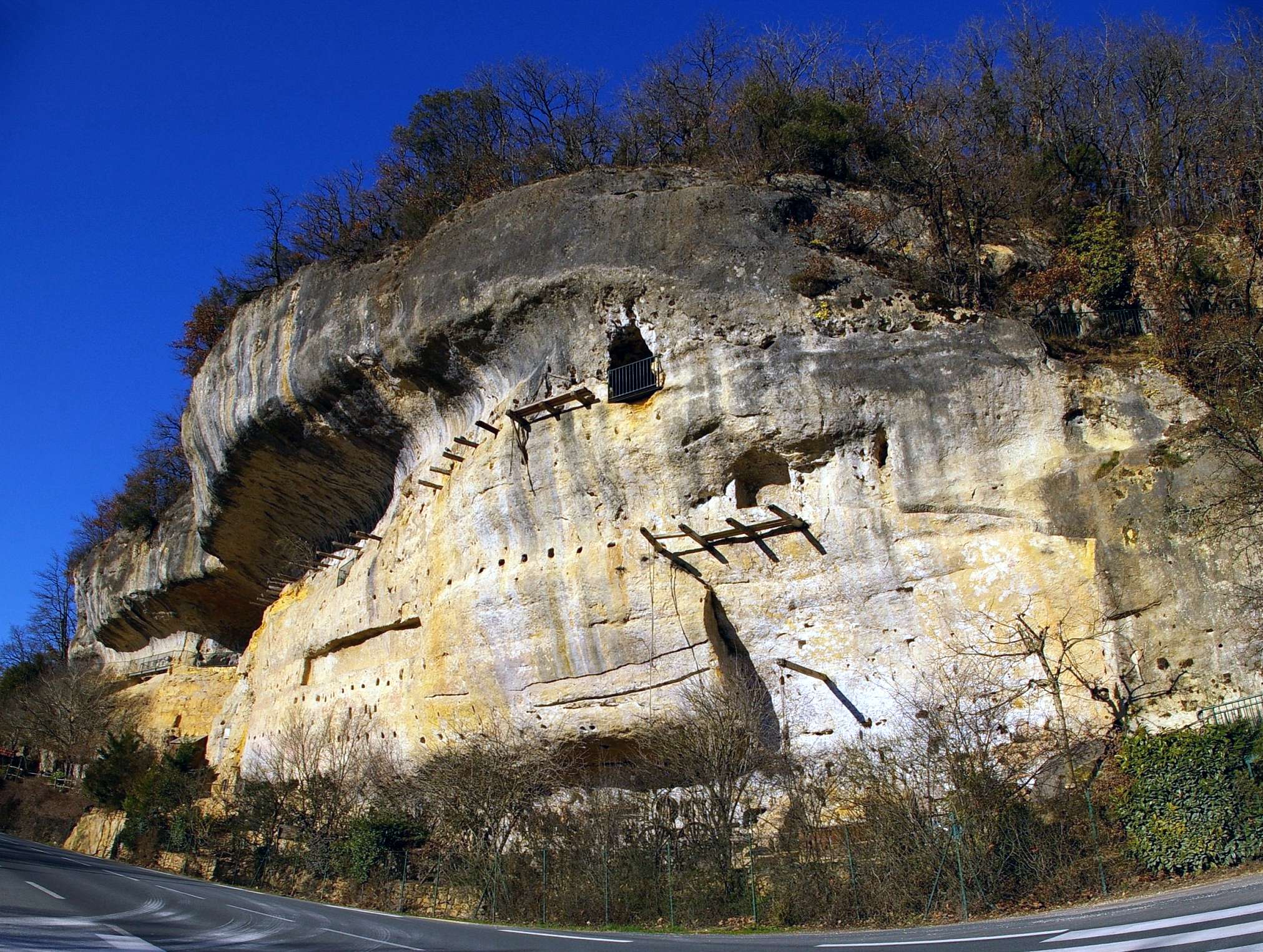
Roc de Cazelle
The Roc de Cazelle has been inhabited since prehistoric times, and the 25 000 year old Venus of Sereuil was found here. It has been occupied almost continuously since. In the Middle Ages many of the caves were deepened and turned into strongholds during the wars of that time. In recent times the lower caverns were used as dwellings for farm owners and their staff, and the whole area has now been turned into displays for tourists to see how their ancestors lived. It is open every day during the summer season from 10.00 hours to 20.00 hours. (10 AM to 8 PM)

Roc de Cazelle
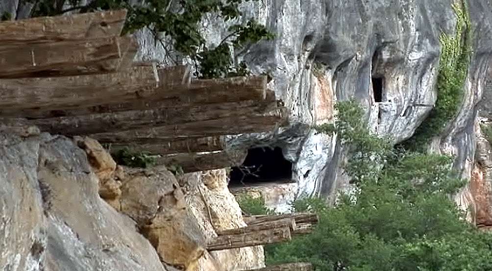
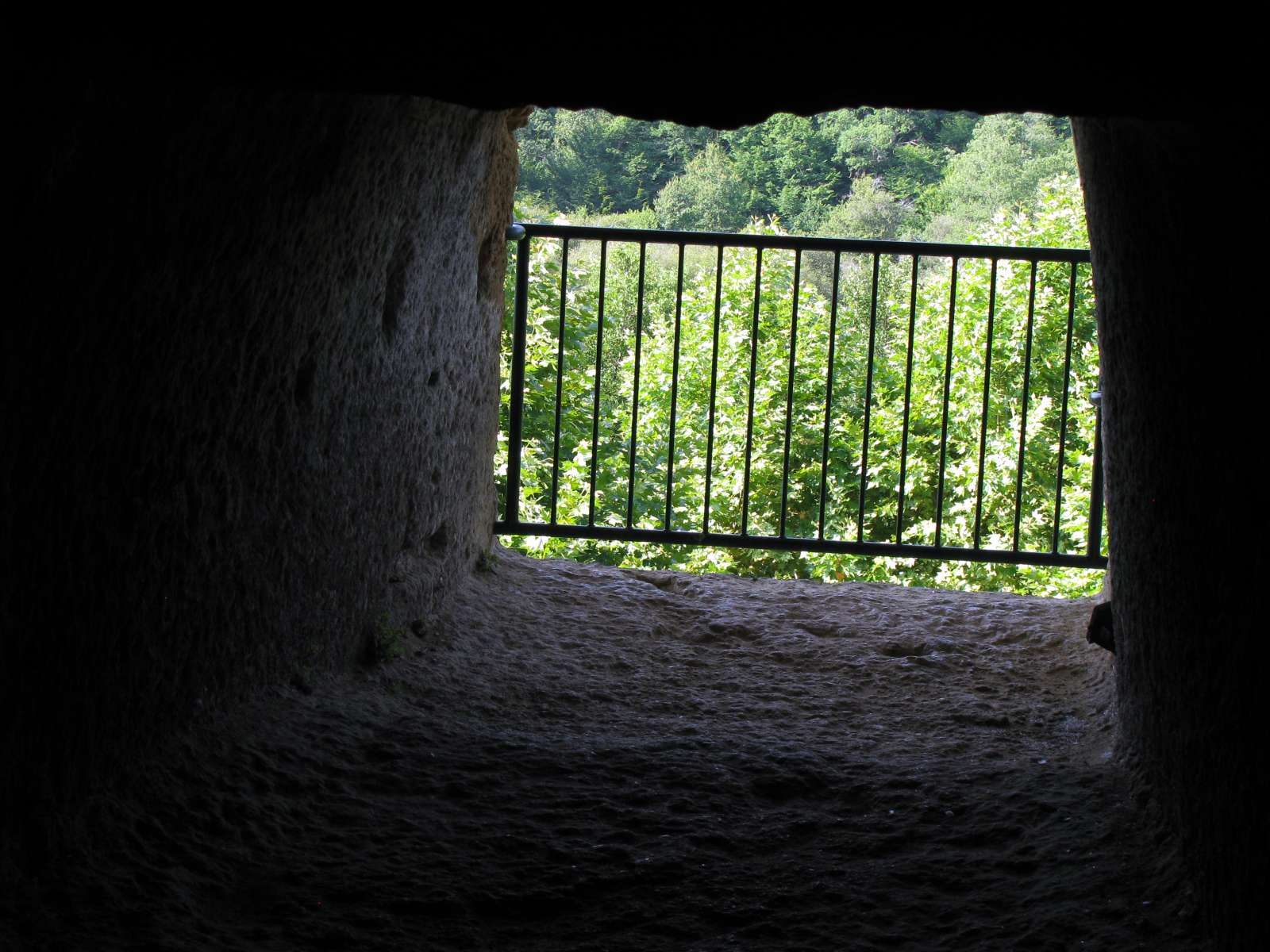
Note the holes in the cliff face for beams to support the floors and roofs of the Medieval buildings which formerly used it as their back wall and part roof, and those wooden beams which remain, in this case for a walkway from one part of the cliff face to another.
Photo: Don Hitchcock 2008
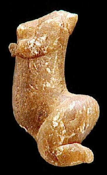
The statuette of Sireuil was found in 1900 by M. Prat, on a road to a stone quarry, at a place called Cazelle Gully, (or Vallon du Goulet, or le Goulet, about a kilometre upstream along the Petite Beune from Roc de Cazelle - Don) in the commune of Sireuil, near Les Eyzies-de-Tayac in the Dordogne. A cartwheel which ran over it in the muddy rut where she lay unfortunately amputated the head and left hand. The material of the object is of amber calcite, slightly translucent, measuring 92 mm in height. H. Breuil and D. Peyrony published a good description thirty years after its discovery in 1930. Duhard (1993)
The Sireuil Venus. See also this file
The Venus de Sireuil was collected in 1900 in the Dordogne. It is made of translucent calcite. It was found in 1900 by M. Prat, on a road to a stone quarry, where a cartwheel which ran over it in the muddy rut where it lay unfortunately amputated the head and left hand which were not recovered. The material of the object is of amber calcite, slightly translucent, measuring 92 mm in height. Aurignacian flint was found 150 metres from the statue, in a quarry. It is estimated to be 25 000 years old.
A female figure carved in a graceful profile, arms raised, held under the breasts. The head and torso are fractured. The legs are short but massive and bent in a kneeling position. A hole made between the lower legs could perhaps be used to insert a stick to hold the statue upright, or so that it might be used as a pendant.
The abdomen and buttocks are protuberant, and the back is arched. There is, between the Tursac and Sireuil venuses an undeniable kinship of style, pose and material.
Photos and text adapted and translated from: http://www.culture.gouv.fr/
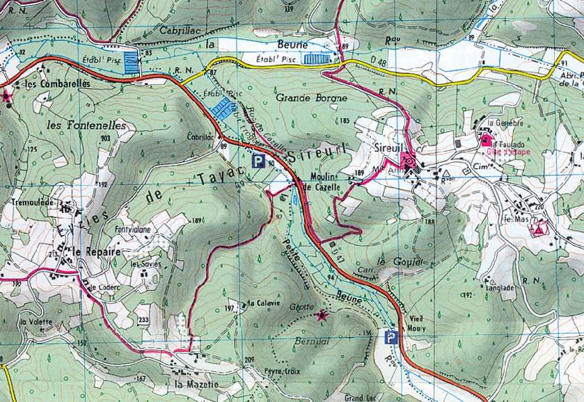
Map of the Roc de Cazelle area, showing le Goulet, where the statuette of Sireuil was found, as well as the quarry mentioned, about a kilometre upstream along the Petite Beune from Roc de Cazelle.
Photo: IGN
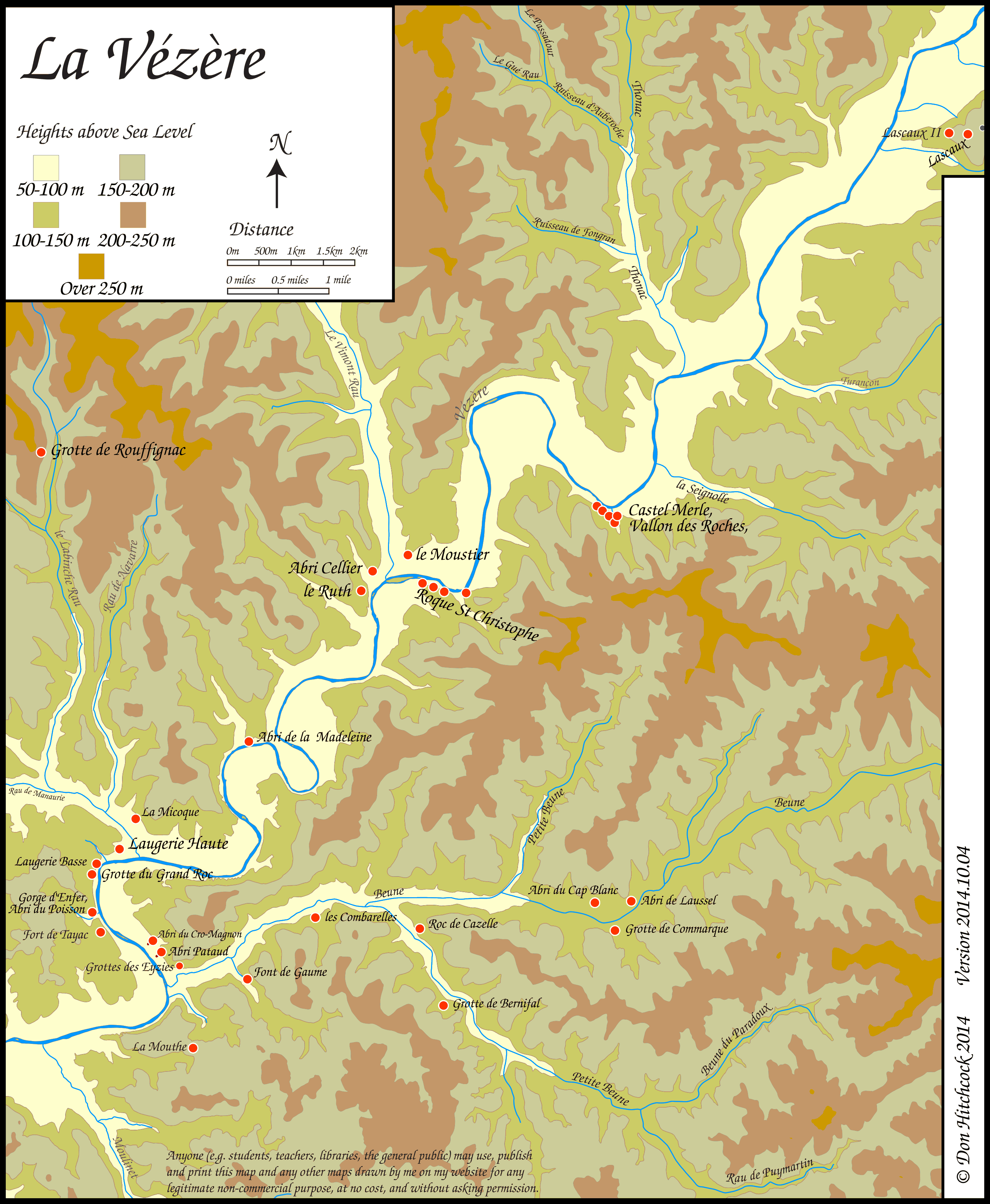
Map of sites in the Vézère Valley of France, including Roc de Cazelle.
If you click on the map you will see a larger map with the ability to click on the sites marked with a red dot and get further information.
Photo: Don Hitchcock
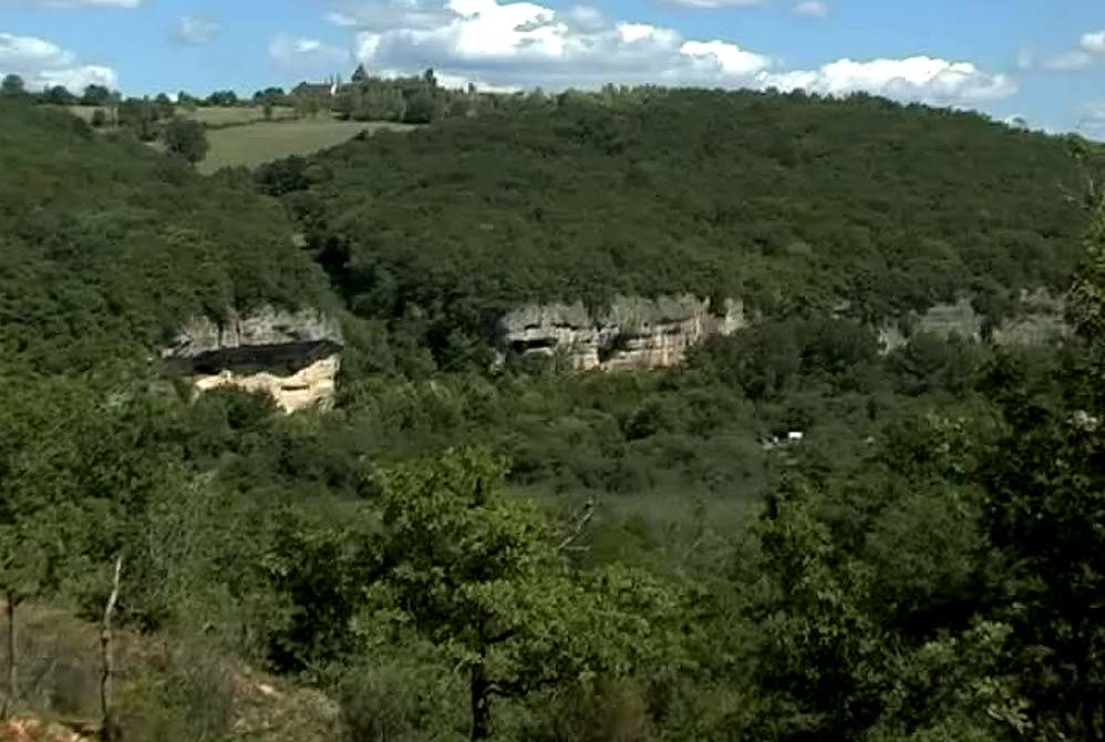
In this aerial shot we can see the top of the cliff of Roc de Cazelle on the left of the photo. The tour of Roc de Cazelle starts on the right of the little valley beside it, and winds up and around the back of the valley and down the left hand side, into the rock of the cliff itself, tracing the old caverns and tunnels carved in the limestone, and emerging on the far left of this photo after traversing a similar valley to the left of the main cliff.
Photo: http://www.rocdecazelle.com/
In this photo of Roc de Cazelle, we can see all the important parts of the Roc de Cazelle cliff, including the walkway on the upper right as it enters the cliff from the valley beside the Roc de Cazelle.
Photo: michel chanaud, Panoramio
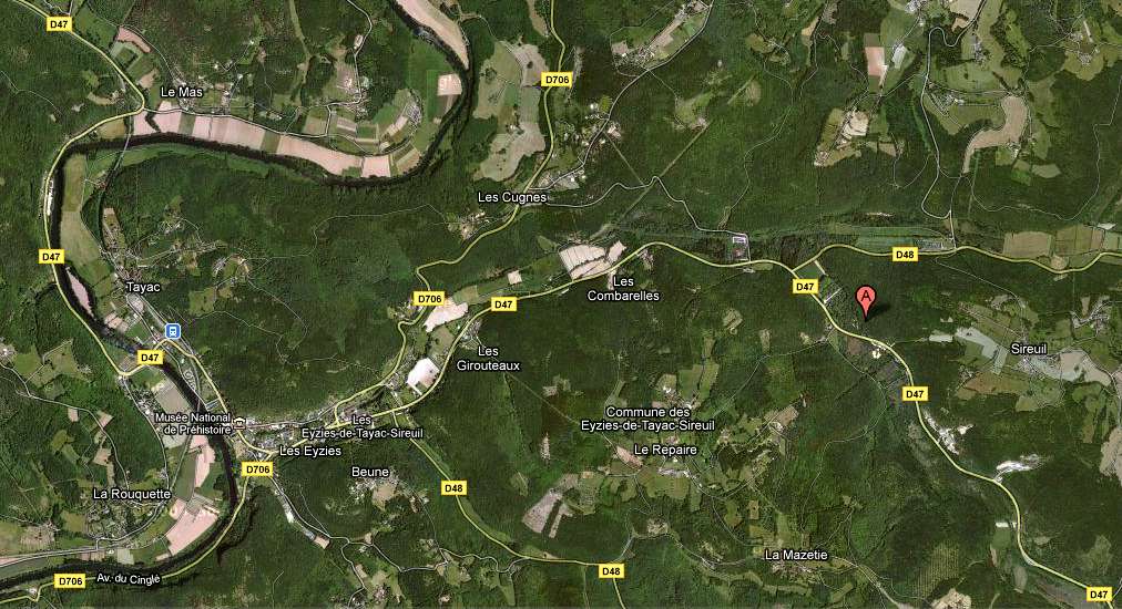
Photo: Google Maps
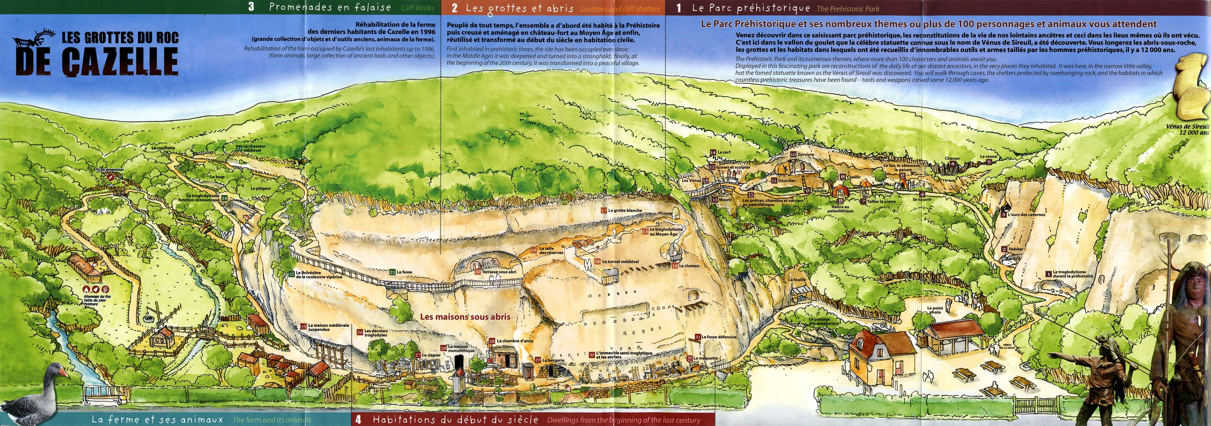
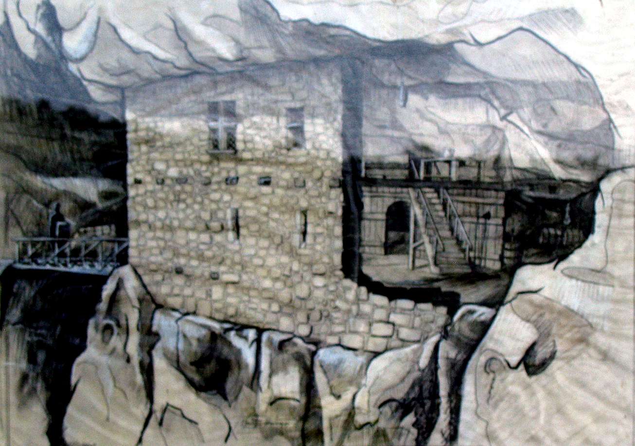
An excellent drawing of the Roc de Cazelle site.
Photo: tourist brochure for Roc de Cazelle
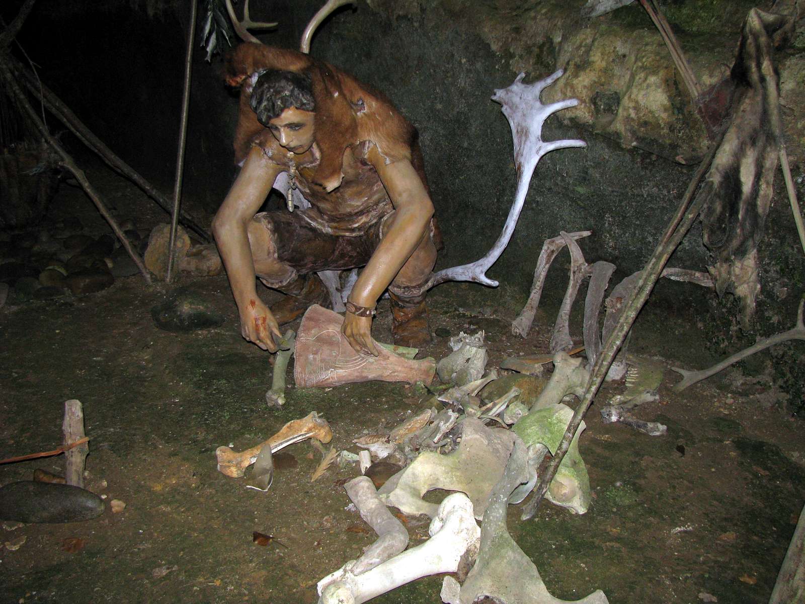
The first displays on the self guided tour were of ice age hunters and gatherers.
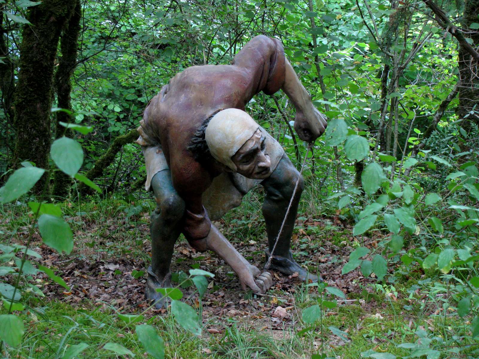
This young man is preparing for a hunt, wearing a hide cloak over the head and shoulders to disguise his shape, or possibly as part of the magic of the hunt.
Photo: Don Hitchcock 2008
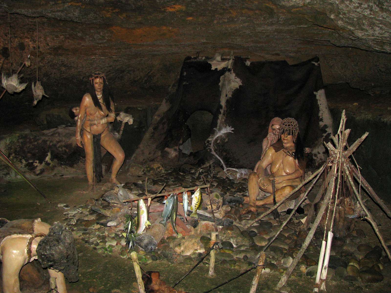
Cooking the fish which were abundant in the area.
On the right of the photo is a method of cooking. If a hide is suspended above the level that flames can reach, it will not burn, but will still get hot enough to boil water or a hunter's stew, though the hide does distort somewhat with repeated use.
Note also the bead work on the woman's head. Beads were very time consuming to make, and were a display of wealth.
Photo: Don Hitchcock 2008

Being able to knap flint as the man at the back is doing, for spear heads and other tools such as engravers (burins) and scrapers was a very necessary skill for all hunters, although some who had particular skill bartered their best pieces for other goods.
In addition, as shown here, hides were a basic commodity that were used for a multitude of purposes, from curtains to clothes, just as today, and the preparation of both hides and flint tools was a part of normal daily routine, though perhaps by different members of any particular group.
The spears resting against each other are of the thrown type, much thicker and heavier than the ones which were launched from a spear thrower or atlatl, a superior method of hunting game.
Photo: Don Hitchcock 2008
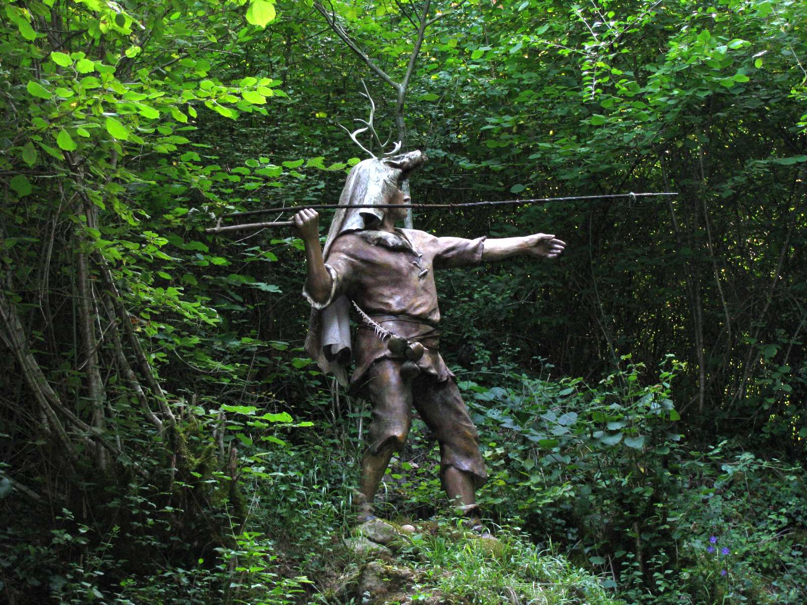
This shows the method of using a spear thrower or atlatl. The spear is very light and whippy, which is important for it to be thrown accurately and for a long distance.
Normally it would be fletched with feathers, not bare as shown in this example. Note also the cloak over the head, and the deer antlers attached to the top of the cloak, used as camouflage so as not to scare the game unnecessarily.
Photo: Don Hitchcock 2008
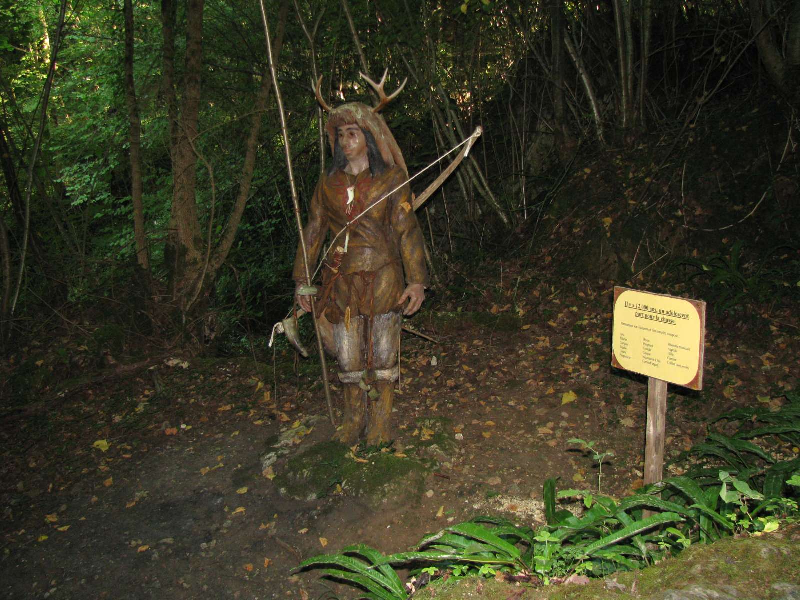
This young man, dressed for the hunt about 12 000 years ago, also has a cloak with antlers, but is carrying an invention best adapted for forest hunting - the bow.
As the ice ages came to an end about 10 000 to 12 000 years ago, the forests which replaced much of the open grasslands typical of the ice ages grew ever larger in extent, and developed thicker understories, and the bow was better adapted for these tighter spaces. In addition, the bow is able to shoot further, faster, and more accurately, although as a hunter increases in strength he or she should swap to a bigger bow with a greater draw strength, which means making a new weapon.
In contrast, the one atlatl or spearthrower can be used by anyone, or by the same hunter as he or she becomes stronger - or weaker! - and they are easier to make well. A bow is, in its ultimate form, a very complex hunting weapon.
Photo: Don Hitchcock 2008
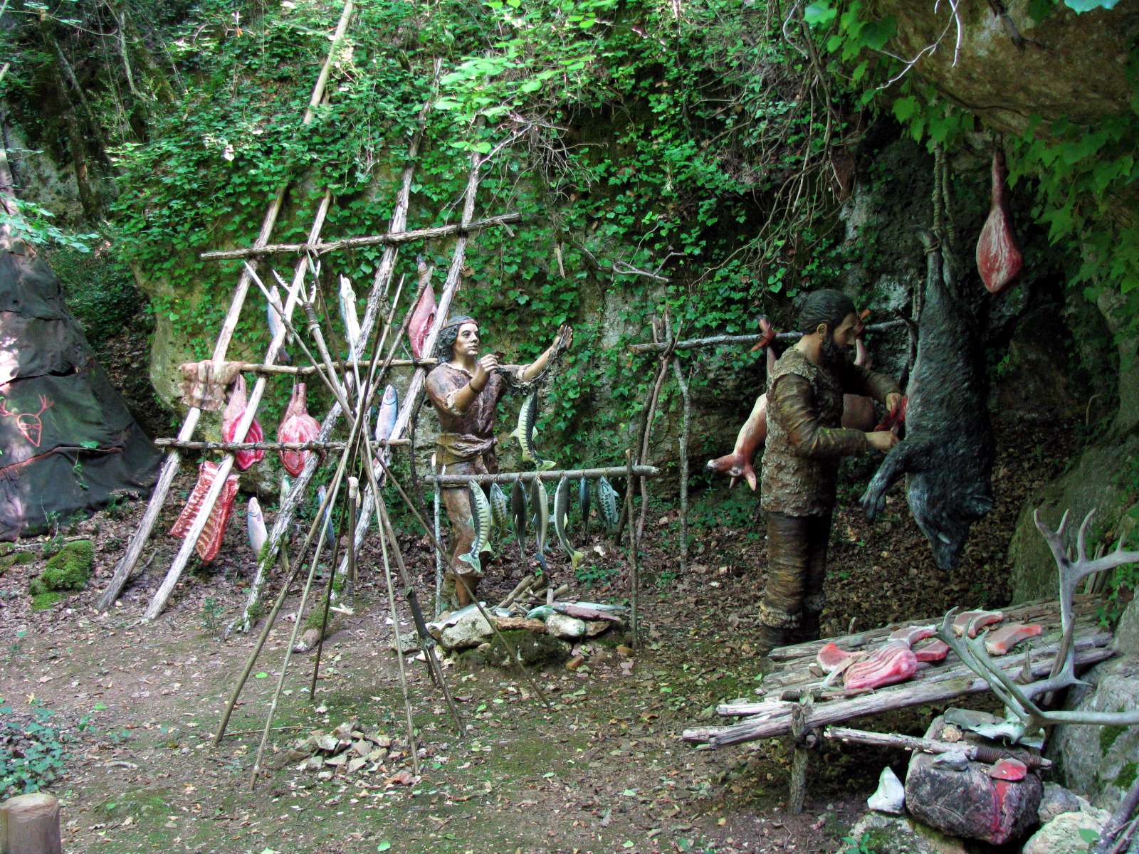
The results of the hunt had to be prepared carefully for storage, as there was no refrigeration, at least in summer, which could get quite warm, even in the ice ages. Methods included drying and smoking over a fire, or in winter by cutting into smaller portions and leaving outside, but protected from carnivorous animals, in shade and freezing conditions. Normally the fish would be cleaned of their guts and scales before preparing for storage.
In colder climates such as the steppes of Siberia, smaller portions of large animals could be buried in holes dug in the permafrost, but this was not an option in this part of France.
The man on the right appears to be gutting the pig, but this is normally done in the field as soon as the pig is killed, to make the carry home weight lighter, unless the entrails are going to be used for other purposes, in which case no time must be lost getting it home before spoilage occurs.
Photo: Don Hitchcock 2008

Here a flint knapper plies his craft in front of a tent made of poles and skins. Antler and bone were also important sources for tools and useful objects which could be shaped and decorated with the flint tools.
When the hunters left the confines of the Vezere valley and the security of the abris or shelters of stone, they had to create their own semi-permanent dwellings from what was available. The abris would have been good to use, and were used by many people during the bi-annual migrations of reindeer through the valley to and from summer upland grazing areas, and the annual migration of salmon up the rivers, but the area could not support that sort of population year round.
And in any case, the flatlands nearby well watered by the Dordogne and the Garonne Rivers were a wonderful resource of grazing animals which prefer the open plains rather than river valleys and forests.
Thus, they would have hunted horses, bison, aurochs and mammoths which did not often venture into the narrow valleys.
That these animals were important to the inhabitants of the Vezere Valley and its tributaries is evidenced by the frequency with which they were depicted on the walls of their painted caves.
Photo: Don Hitchcock 2008
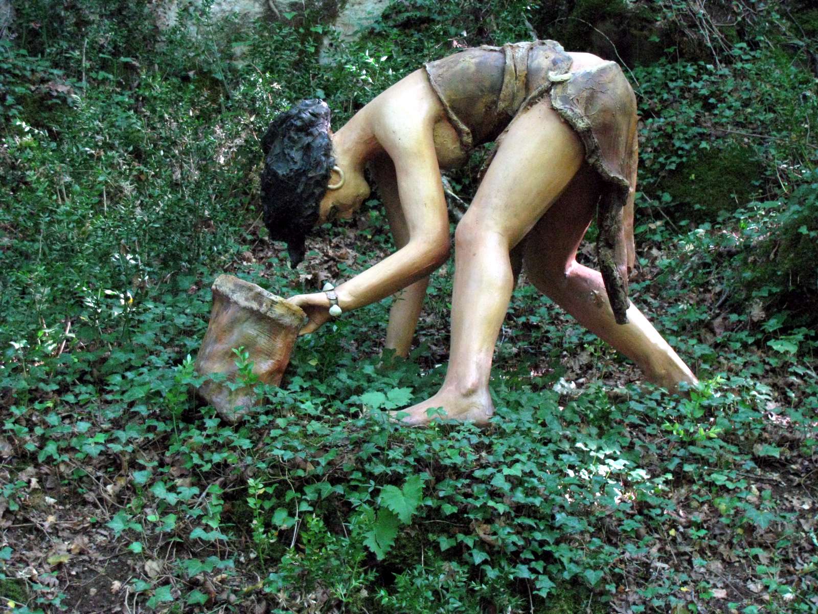
Hunters and gatherers often gained more of their calories from gathering than hunting. Hunters often return from a hunt with nothing for their efforts, whereas the fruits of the forest and the rivers are, though not as exciting to harvest, nor, when successful, do they provide such an abundance of food as, say, a mammoth, but are nevertheless more reliable.
Here a woman gathers mushrooms in a leather basket. Baskets were made from whatever was available, and rushes and thin pliable creepers and thin branches of trees such as willow, sometimes split, were used, as well as birchbark when available.
Photo: Don Hitchcock 2008
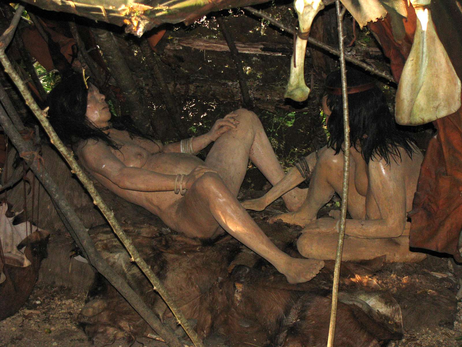
Childbirth has always been a difficult and dangerous time for mothers. It is especially at times like this that a shaman or someone skilled in medicine and healing was invaluable for a group of hunter gatherers. Many women died in childbirth, and many children did not survive their first year.
Here a woman has come to term, and is being helped and comforted by a close relative.
Photo: Don Hitchcock 2008
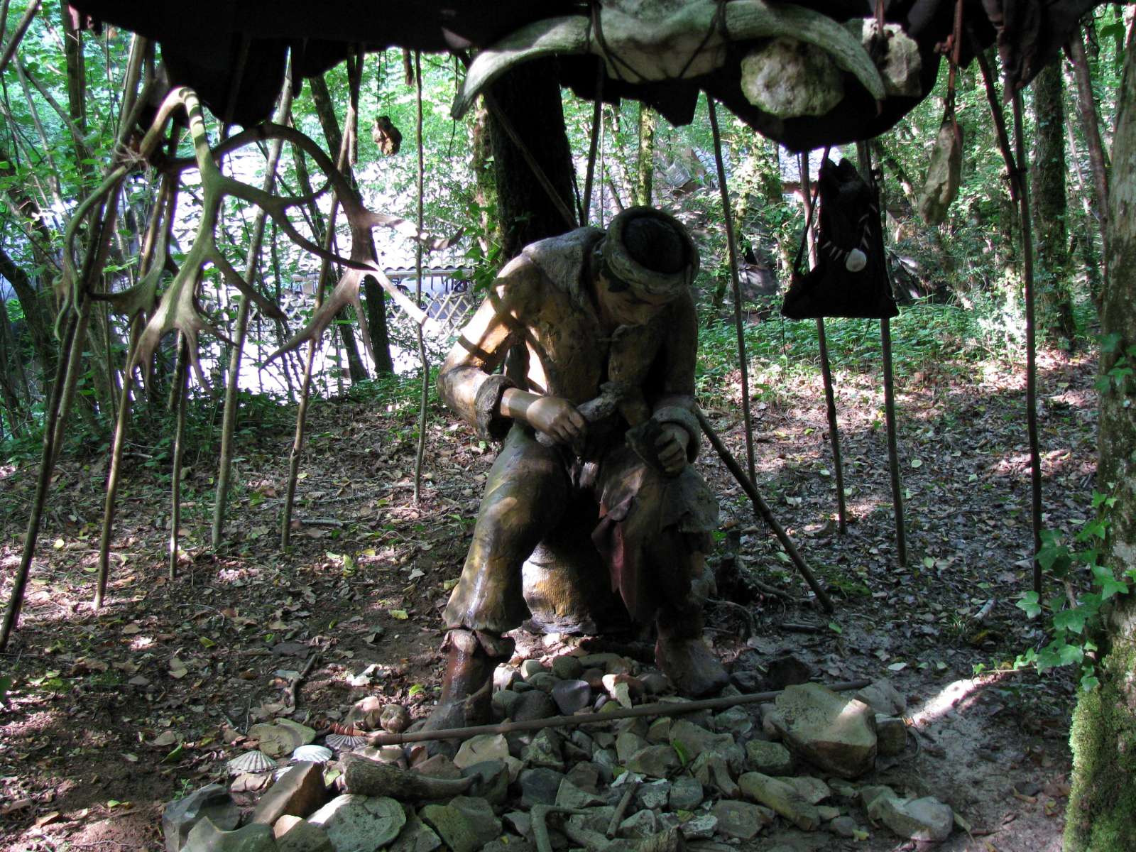
Flint knapping is a somewhat solitary craft, the worker must concentrate and not be distracted by other things happening around the knapping area. For this reason, this flint knapper has set up a shelter devoted specifically to the task.
It has the added advantage that the sharp waste flakes produced, or debitage, are well away from bare feet.
Photo: Don Hitchcock 2008
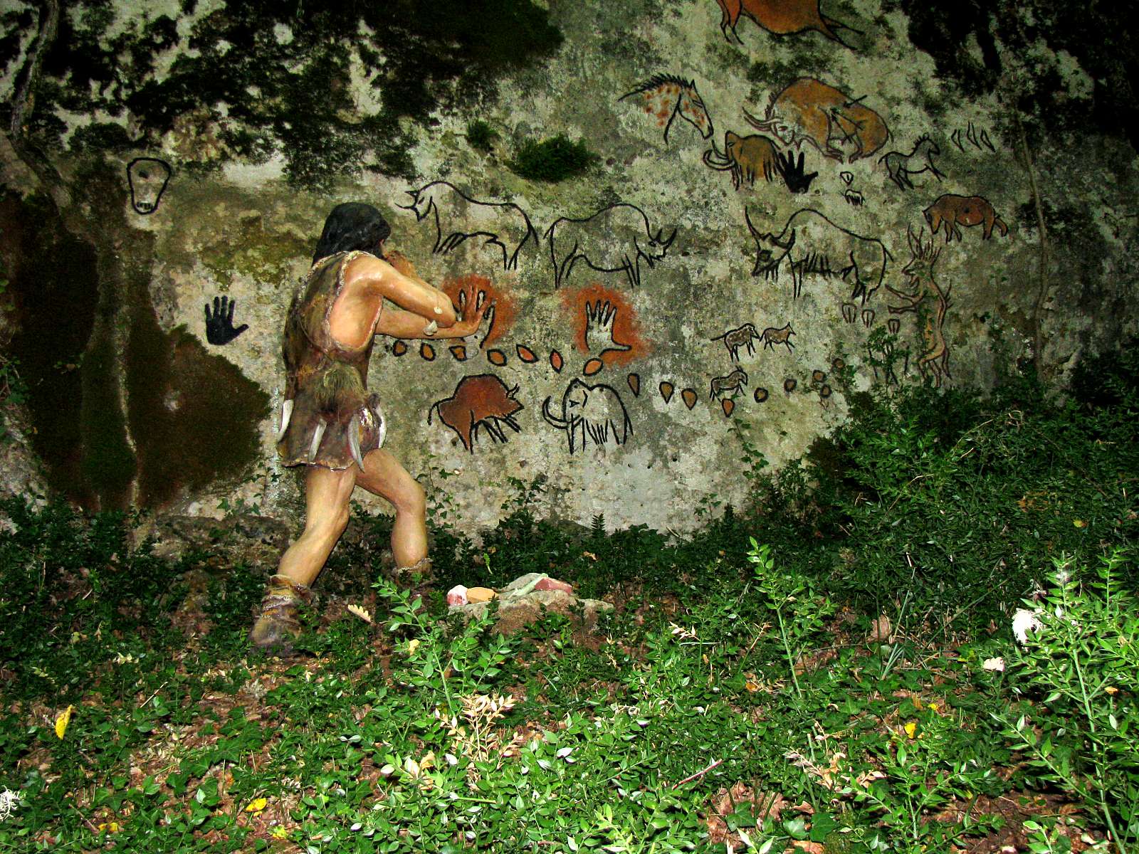
The people of the abris or rock shelters of this area decorated their caves and abris (rock shelters) with paintings, carvings and engravings of the animals they saw and hunted in the area. In this recreation, a Cro-Magnon man from the area decorates a cliff face with an image of his hand, created in the negative by blowing a liquid mixture of pigment (often red ochre or black manganese dioxide) and water over the hand, which acted as a stencil. In order for this to stand out, the modern artist has outlined the hand in black, which was not usual.
No doubt there were paintings such as this on exposed cliff faces, but twenty thousand years of the elements have erased all trace, except where engravings or carvings were made into the limestone.
Photo: Don Hitchcock 2008

There were both the large cave bear and the (on average) smaller though still formidable brown bear in Europe in ice age times, though there is considerable variation in the sizes of these bears, depending on their habitat and available food.
Both would have been dangerous and unpredictable animals to hunt with the weapons of the time, but would have provided a large amount of meat and fur for a successful group of hunters with the right weapons and techniques.
Photo: Don Hitchcock 2008
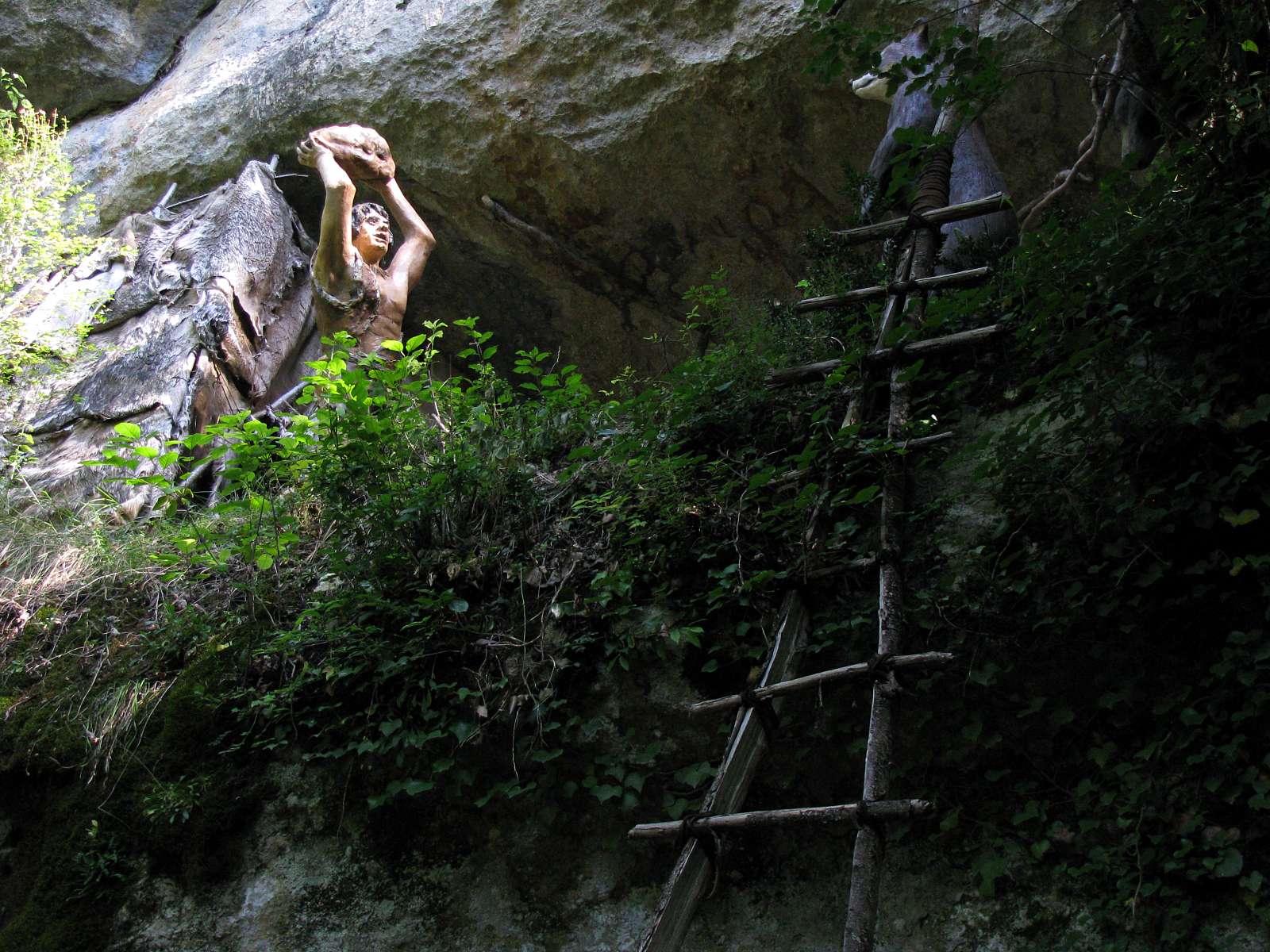
A somewhat fanciful encounter between a bear and a Cro-Magnon man on a ledge reached by a well constructed ladder. A spear might have been closer to hand and more effective against the bear, though not perhaps as dramatic!
The ladder is worth a closer look. The rails are made from one long straight tree, split down the middle, and it is both strong and light, and able to be raised to the level of the rock ledge when required, fairly easily constructed from available materials and adequate for the task.
The shelter on the ledge is constructed of hides attached to a light framework of poles, and no roof is necessary, since the ledge is overhung by the cliff above. It would have been quick and easy to make and to maintain when repairs were necessary, once the hides were put aside for the task.
Photo: Don Hitchcock 2008
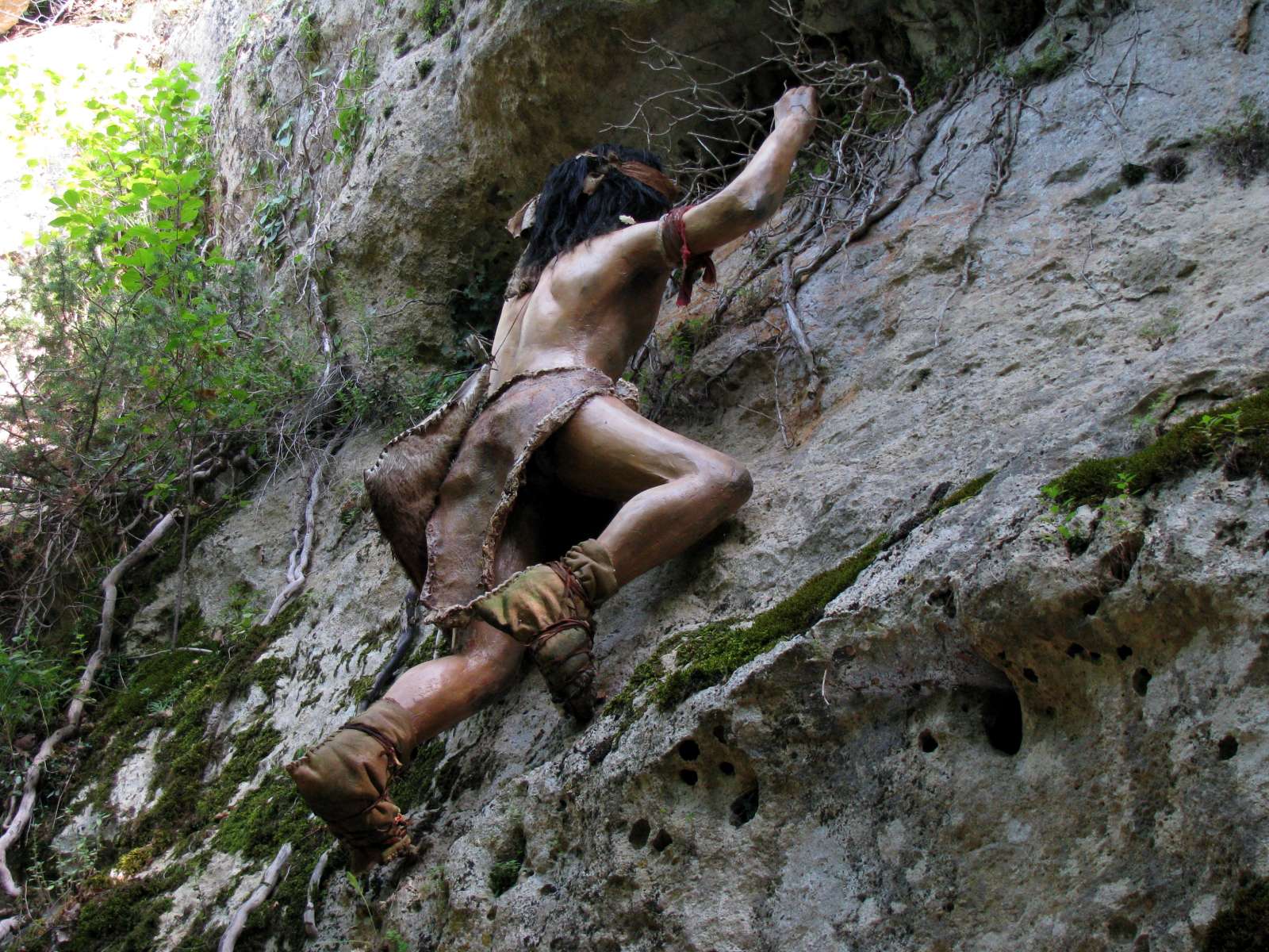
Climbing the limestone walls must often have been necessary, either to examine ledges for suitability as living quarters, or when hunting for birds' eggs or robbing beehives.
The sculptors of these figures have done a superb job, the figures are both anatomically correct, showing every muscle and tendon, coloured in a life-like manner and in very natural poses, with the impression that a moment in time has frozen, and we are able to look at events of ten or twenty thousand years ago as though they were happening before our eyes.
Photo: Don Hitchcock 2008
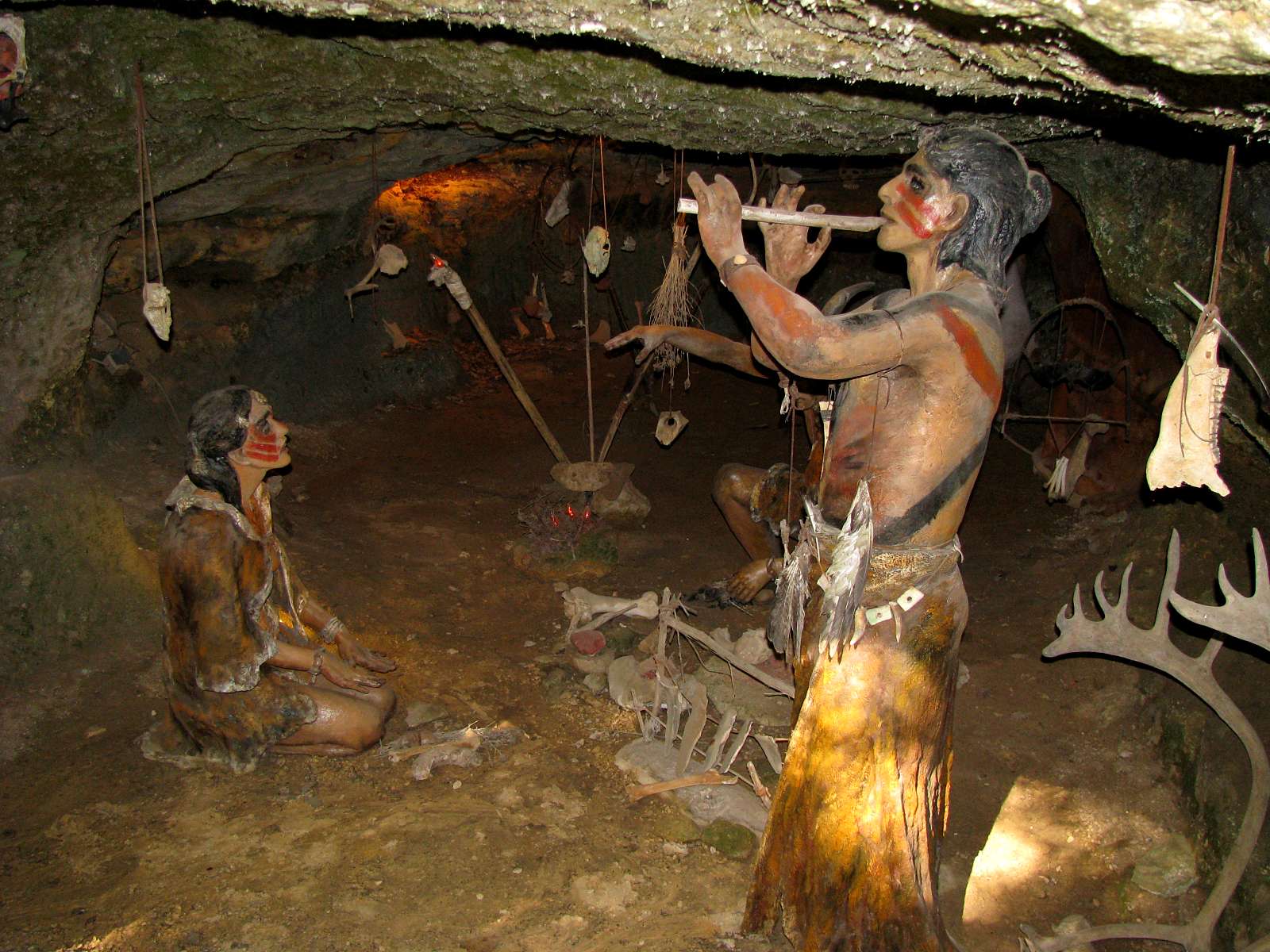
Music and dancing were a normal part of the life of ice age people. There are many examples from this period of flutes, bullroarers, idiophones (notched bones which were stroked with a stick or bone), shoulder blades of mammoths hit by a mallet, and other items obviously used for music.
See the images and text below concerning musical instruments found in the Dordogne and other parts of southern France.
In addition, there was always the human voice, whistling, clapping hands and thighs to make both melody and rhythm.
Photo: Don Hitchcock 2008
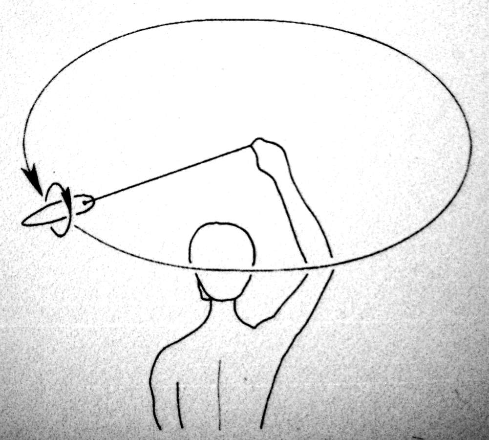
(See the image below this one for an example of a bullroarer from Lalinde, Dordogne)
Bullroarers were used as noise makers during the Paleolithic, and are swung around the head from a string, and the shape induces it to rotate in a plane vertically to the plane of rotation around the head, which produces the characteristic sound.
Photo: Kathy King 2010
Source: Display at Musée d'archéologie nationale, Saint-Germain-en-Laye
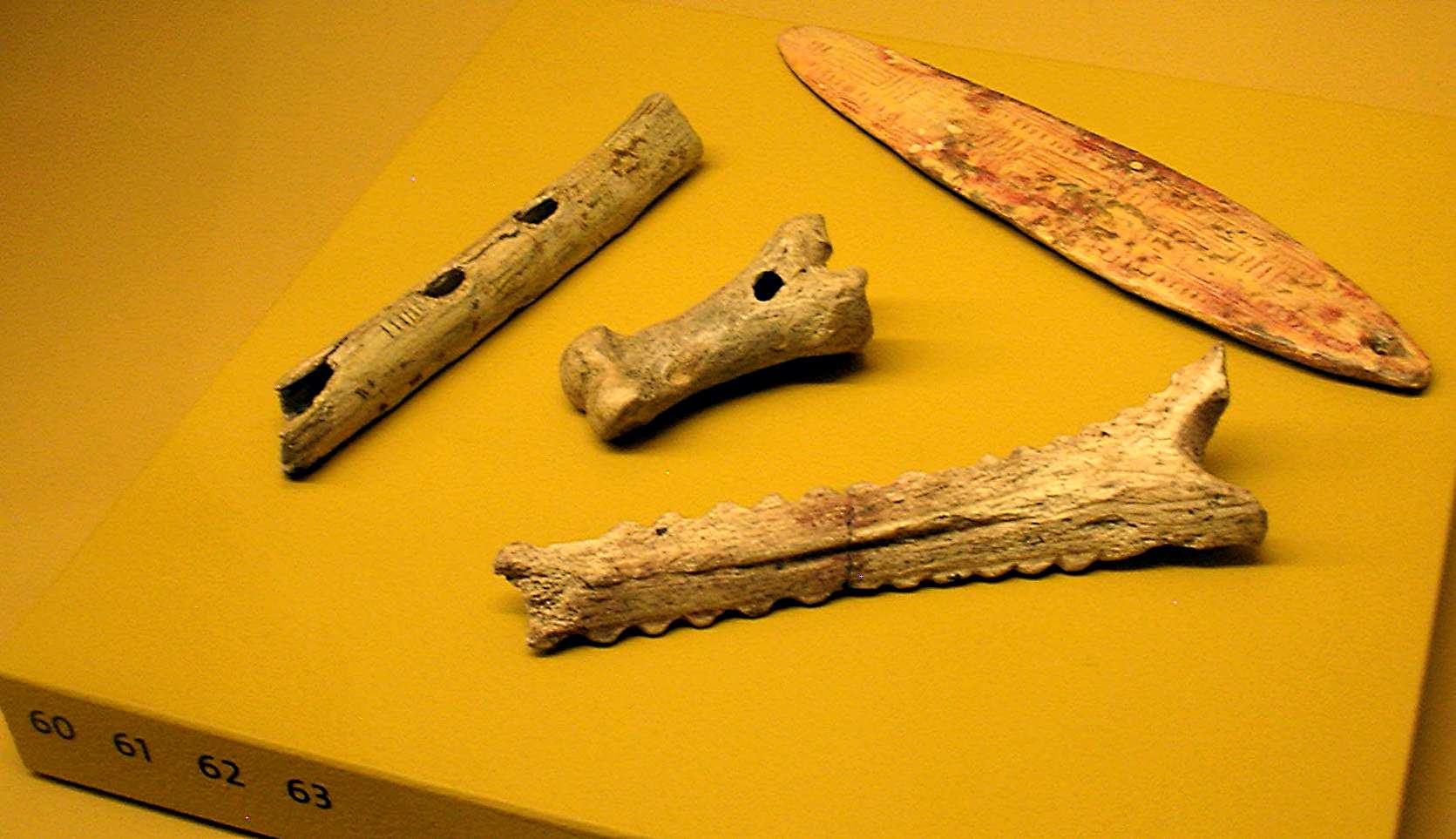
Music and dance are ephemeral art forms. However the existence of music
in the Paleolithic is attested by the discovery of several
types of instruments: flutes, whistles, bull-roarers and scrapers.
Drums probably existed in the Paleolithic, but these instruments made of wood and skin are rarely if ever preserved. However, in some caves, calcite sheets or curtains showing traces of percussion testify to the rhythmical talents of prehistoric musicians.
60: Bone flute, facsimile, from Isturitz, Atlantic Pyrenees. Aurignacian, between 40 000 and 26 000 years ago
61: Whistle in bone, original, from Laugerie-Basse, Dordogne.
62: Bullroarer or rhombus or turndun, facsimile, in reindeer antler, Lalinde, Dordogne. Note the colour, originally from ochre, and the regular straight lines and rectangles decorating it.
63: Scraper, or scraped idiophone, original, from Mas d'Azil, Ariège. This one seems to have been made from a salvaged broken spear straightener.
Scraped idiophones (an idiophone is defined as a musical instrument from which the sound comes from the natural sonorous quality of the instrument itself, not from a stretched string or hide or enclosed column of air) are rasps or notched sticks over which another stick is scraped, resulting in a series of beats.
Photo: Kathy King 2010
Source: Image and translated and adapted text from the display at Musée d'archéologie nationale, Saint-Germain-en-Laye
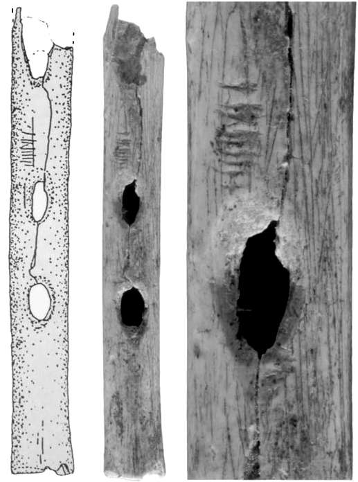
This is a photo of the original flute from the Aurignacian culture of Isturitz, which would place it between 40 000 and 26 000 years ago, shown in facsimile above.
Victor Mair (Mair, 2006) describes a collection of prehistoric flutes made of vulture wing bones:
... a very impressive collection of Upper Paleolithic flutes (or pipes) from Isturitz in southwestern France. Consisting of more than twenty separate specimens, the Isturitz flutes range widely in date from the Aurignacian to the Magdalenian (between ca. 20 000 and 35 000 years ago).
Two of the most complete pipes are from the Gravettian levels of the cave, ca. 25 000 years ago. They are extremely well made of vulture ulnae, bear finely etched identifying or notational marks, and display evidence of having been extensively used.
The flute above is artifact 77142(a) [DB 4.1] from Buisson (1990). The close-up image of the finger hole on the right shows a set of marks.

Flute from Isturitz
The brochure from the official cave site, at http://www.grottes-isturitz.com/grottes-isturitz/calendrier_gb.htm, says that it is 31 000 years old.
Note that this image has been flipped horizontally to agree with the facsimile and photos above.
Photo: From the Owner, via Google Earth
Some observations from D'Errico et al (2003):
From the outset we were struck by the pipe’s sophistication. Although archaeologists have sometimes been tempted to classify these things as 'simple', even 'primitive' instruments, close inspection revealed some intriguing musical choices and functional asymmetries. Bearing in mind how very ancient they are, with a date-range currently estimated, for most of them, at between ca. 20 000 and 35 000 years, these seemed remarkably advanced, and clearly justified careful reevaluation.Photo and text above: http://www.flutopedia.com/dev_flutes_euroasia.htm

Some paintings and engravings, especially in caves, could only have been created after the construction of significant wooden platforms so that the artist could get high enough to reach the surface to be painted.
In this case, as in many prehistoric examples in the area, the artist has first prepared the surface by removing the surface patina of grey lichen covering the exposed rock, to create a pure white surface for the painting. Many such images consist of a drawn outline later infilled with coloured pigments to complete the painting.
Examples of the need for such constructions include many of the paintings of Lascaux, and the roof drawings of the Grand Ceiling of Rouffignac, both in the Dordogne / Vezere valley area, with the Grand Ceiling having a yawning pit beneath it, with slippery clay sides forming a funnel to another gallery far below. The artists had to first construct a wide circular platform, of which there was evidence in historical times, before attempting to complete the paintings. The resulting large platform, perhaps six metres across, was then only one metre or so below the ceiling at that point, so the artist would have painted the frescoe on his back or on his knees. See below.
Photo: Don Hitchcock 2008
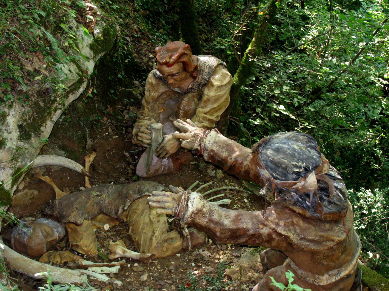
Life was usually short for men as well as for women. This man has lived long enough to have grey hair, which is unusual, but most were not so fortunate. Most men did not live past 30, and 45 would be exceptionally old. Hunting accidents, a broken limb, exposure, infections from wounds, disease all took their toll.
Here a man is laid in his final resting place with great sorrow by his close relatives, with some of the tools and mementoes important to him in life.
Photo: Don Hitchcock 2008
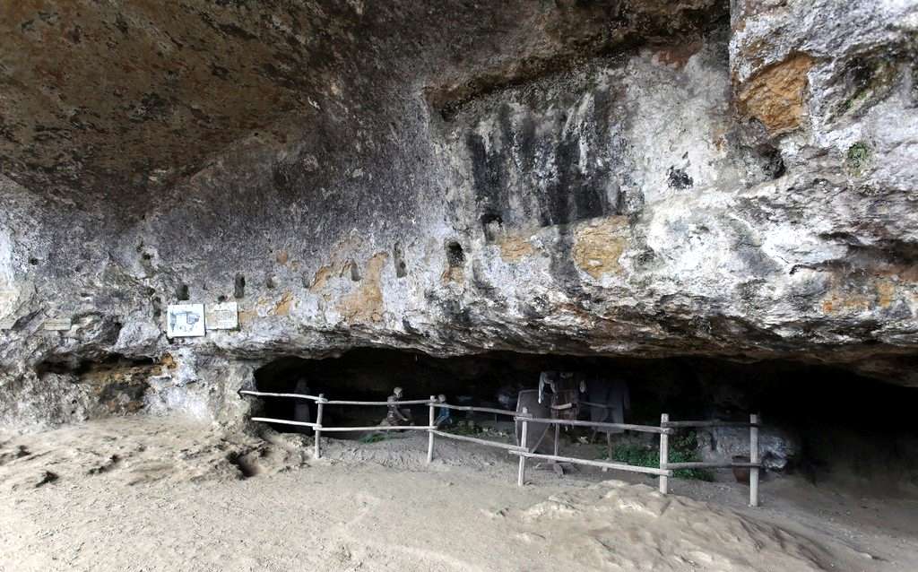
Just after this display, the path entered a (presumably recent) tunnel into the limestone cliff. The tunnel led past this room:

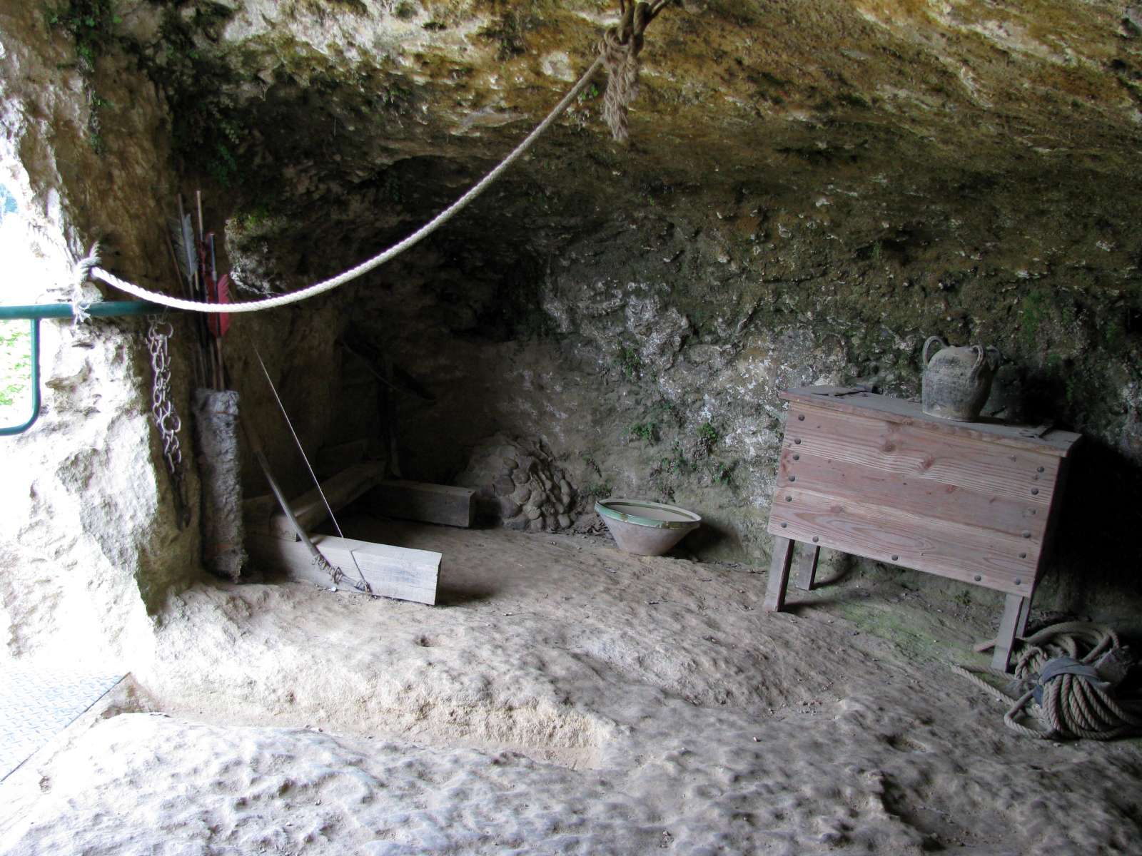
This room, entirely artificial, cut by the hand of man more than a thousand years ago, was originally only accessible by a cantilevered balcony set into the rock. It was the ultimate refuge, and Cazelle had another five such places if the fortifications at the foot of the cliff were overcome.
This was a defensible and impregnable military structure, and had amongst other things a cistern for the supply of water, fed by a drip line from the cliff, and three rings in the ceiling which were used to hang lights, food and miscellaneous objects. The stones piled in the corner were used as projectiles in case of attack, in addition to traditional weapons (crossbows, spears, bows etc.)
Access to the balcony was via a square section tunnel which exited at the cliff face, and at that point one balcony led to this room, while another led to the area now called "the terrace", which at the time was converted into a stone and timber refuge which could accommodate the extended family of the Lord of the area.
Photo: Don Hitchcock 2008
There was a considerable drop to the ground below, and presumably in times of attack, the occupants would destroy part or all of the balcony behind them, then lower themselves down by rope when the danger had passed.
(left) View from the room
(right) View of the outside of the room and the remains of the balcony from ground level. The square section tunnel (and its guard rail) which exits the cliff further along the former balcony may be seen to the left of this photo.
Photo: Don Hitchcock 2008
These are the beams which were used to support the walkway or balcony to the secure fortified rooms in the complex.
Photo: http://www.rocdecazelle.com/

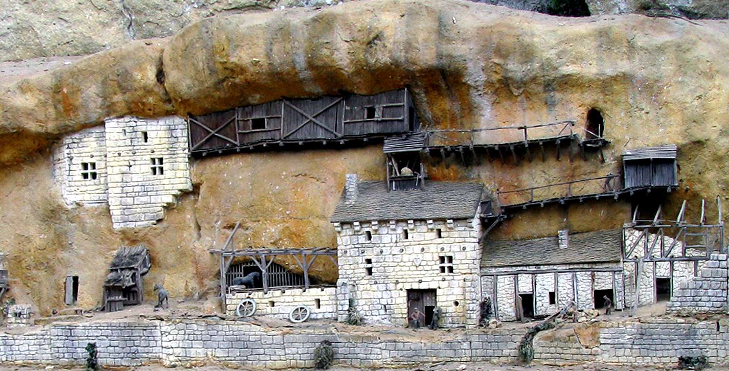
This 1/43 scale model offers a view of the settlement such as it might have looked like in the fifteenth century. This interpretation is based on the study of the marks of anchorages in the walls and floor. The walls were built of limestone, the roofs of slate, the woodwork in oak, chestnut and acacia. All these materials were obviously sourced from the quarries and woods nearby.
The central building was used as a stronghold belonging to the lord. The only possible access to the upper levels is through the medieval rectangular tunnel, which exits the cliff face at the point where the open balcony from the single room on the right meets the closed balcony leading to the central building high on the cliff face. The other houses are reserved for peasants and the animals they looked after.
Photo: Don Hitchcock 2008
This is a close up of a very interesting part of the complex, the last refuge, which is in two parts, the single artificial room hewn from the rock, and the larger place where a whole extended family could last out a seige. Here we can see that the square medieval tunnel giving access to the final stronghold has two exits at different levels, the lower to one small room, the higher to a much bigger area at what is called the terrace, hidden in this view by the stone walls used to enclose it.
Photo: Don Hitchcock 2008

Since the construction of the refuge above, other tunnels were dug into the rock, eventually connecting many of the refuges, and crossing vertical natural holes in the cliff.
Photo: Don Hitchcock 2008
Medieval Tunnel
This tunnel of square section allowed the only communication with the external fortified homes.
It comes out of the rock face immediately below one part of the former balcony referred to earlier, and beside its continuation. Thus there was a connecting section of balcony and steps to connect this room with the balcony to the fortified room shown above on this page.
The guard rail and the square hole may be seen on the photo of the outside of Roc de Cazelle at the top of this page. The quality of the work is exceptional.
Photo: Don Hitchcock 2008
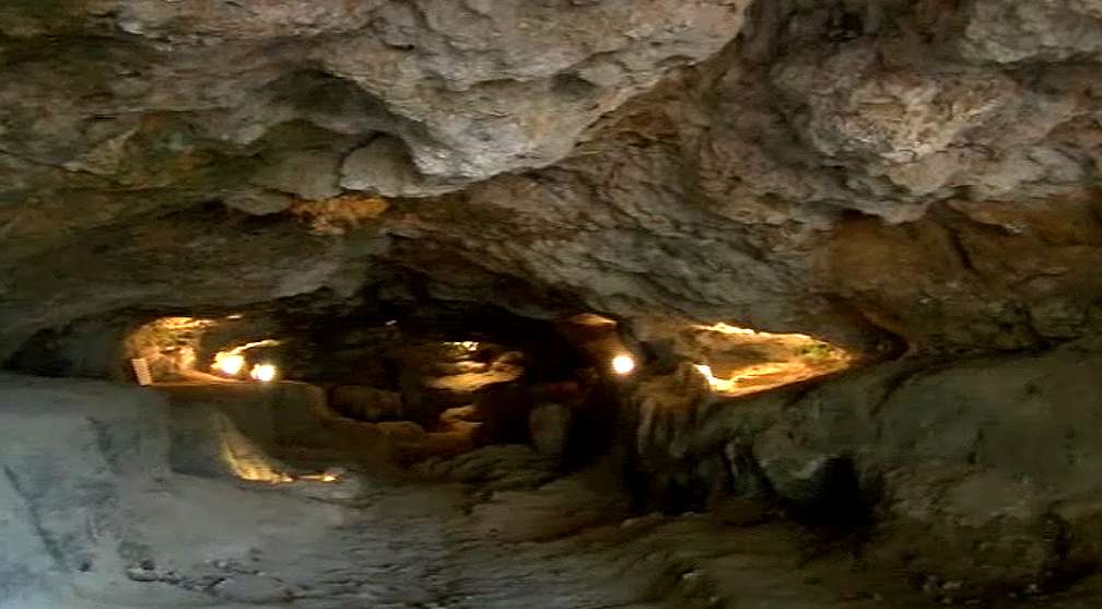
The Sanctuary, La Salle des Réserves
This natural cave of 25 metres in length served as a shelter for the other members of the Cazelle community, the peasants, who came here for safety in this great cavity in case of danger. They found here mild temperatures, they harvested water that dripped from the ceilings, food could be stored here, and again even if the outer fortifications were breached, a cave like this was an indestructible shelter.
From the model of the settlement above, it would appear that the peasants would have gained access to the shelter through the roof of the largest house at ground level, to the square section tunnel, and thence to the Sanctuary, the Salle des Réserves, should the attacking forces enter the lower levels of the house.
Photo: http://www.rocdecazelle.com/
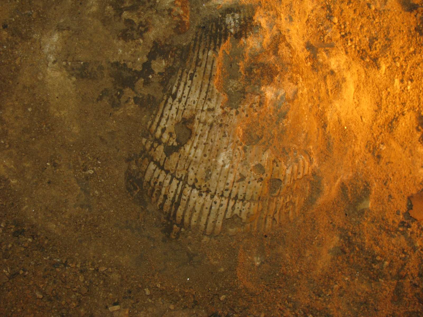
This shell half buried in a matrix of limestone was discovered on 5th September 1998. It allows dating of the rock in which it rests. It is a bivalve that lived here in Cretaceous seas 180 million years ago. It lay on the sand at the bottom of the ocean, and was covered by other calcareous deposits. The whole mass was transformed with time and pressure into limestone, forming the band of limestone in which this cave was excavated over the last one million years.
Photo: Don Hitchcock 2008
The terrace, showing a diorama of medieval times under the overhanging rock.
Photo: Olivier Blandeaux, http://obl91.dyndns.org/roc_cazelle-121110.htm
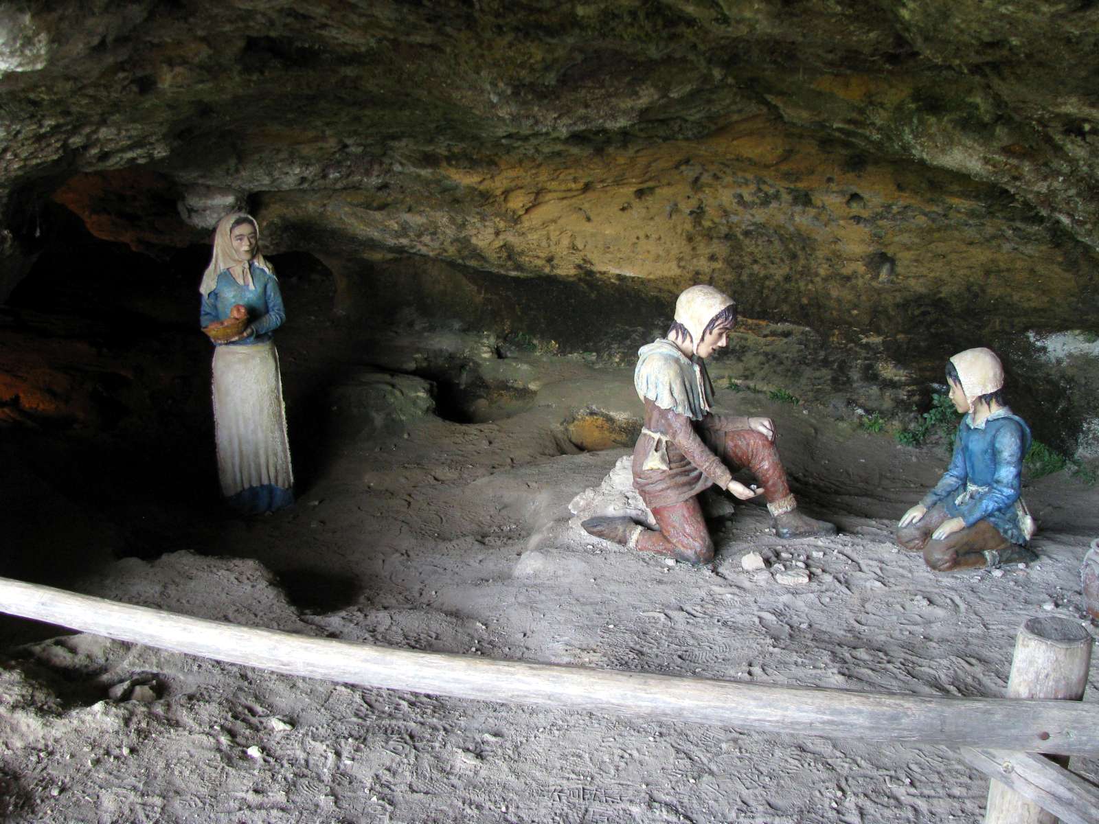
A diorama of Medieval times, showing two children playing, with their mother looking on.
Photo: Don Hitchcock 2008
This structure formerly occupied an area now known as the terrace, shown above.
The terrace extends the cave and was protected in front by a wall which can still be seen in the foundation floor and walls, as well as the wall niches or holes for the beams necessary for the construction of the floor of the house. A bridge was necessary to get in and get out of the west side: underneath, the drop below made passage otherwise impossible. The bridge could be easily defended or destroyed if necessary.
These defensive superstructures, hewn from stone or built of wood, and merging with the cliff and with few openings, brought a natural and effective protection to the city.
Photo: Don Hitchcock 2008

The view from 'Le Guetteur', the lookout.
This position assures the watcher of a perfect view of the valley of the Beune as far as the valley of the Vezere. One blast of the trumpet was sufficient to warn the inhabitants of the Roc de Cazelle and its environs of danger.
There was a system of lookouts right along the Vezere valley so that at the first sign of approaching troops with warlike intent, the whole valley was alerted.
Photo: Don Hitchcock 2008
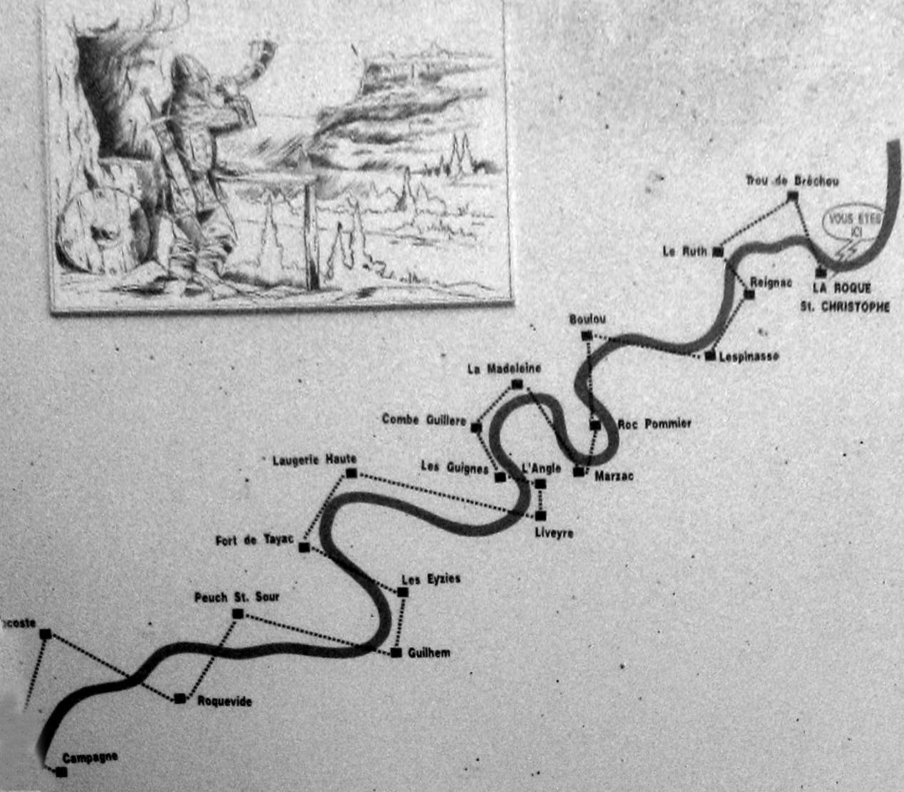
This is a diagram of the main such system along the Vezere valley, on an information board at Roque Saint-Christophe.
As soon as enemy troops appeared at any point along the valley, the whole valley was alerted, and in many cases the side streams such as along the Beune and Petite Beune at Roc de Cazelle, and each settlement made preparations for defending their territory.
Photo: Don Hitchcock 2008
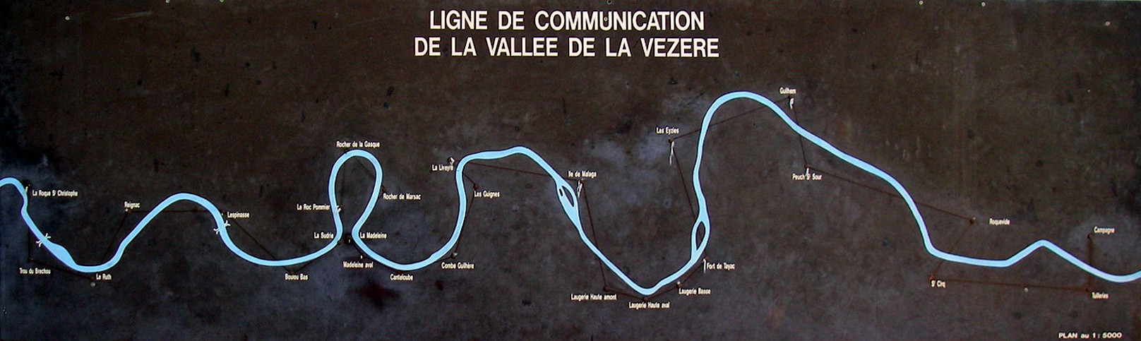
This is a diagram of the main system along the Vezere valley, on an information board at La Madeleine.
Over the total distance of 18 km between the village of Campagne and the fortress of La Roque St Christophe, were located 22 intermediate watchtowers in the cliffs, constantly manned, 1000 years ago.
The watchmen, often installed in small, cramped booths and holes cut in the cliffs, signalled up and down the valley of any approach along the river of prospective enemies. This system was rediscovered and an experiment was performed in 1963 by a team of 22 people who moved into these holes in the cliff to watch and listen. A message sent from Campagne (18 km downstream) arrived at Roque Saint-Christophe in less than 6 minutes, thanks to the signals relayed by hunting horns.
Photo: Don Hitchcock 2008
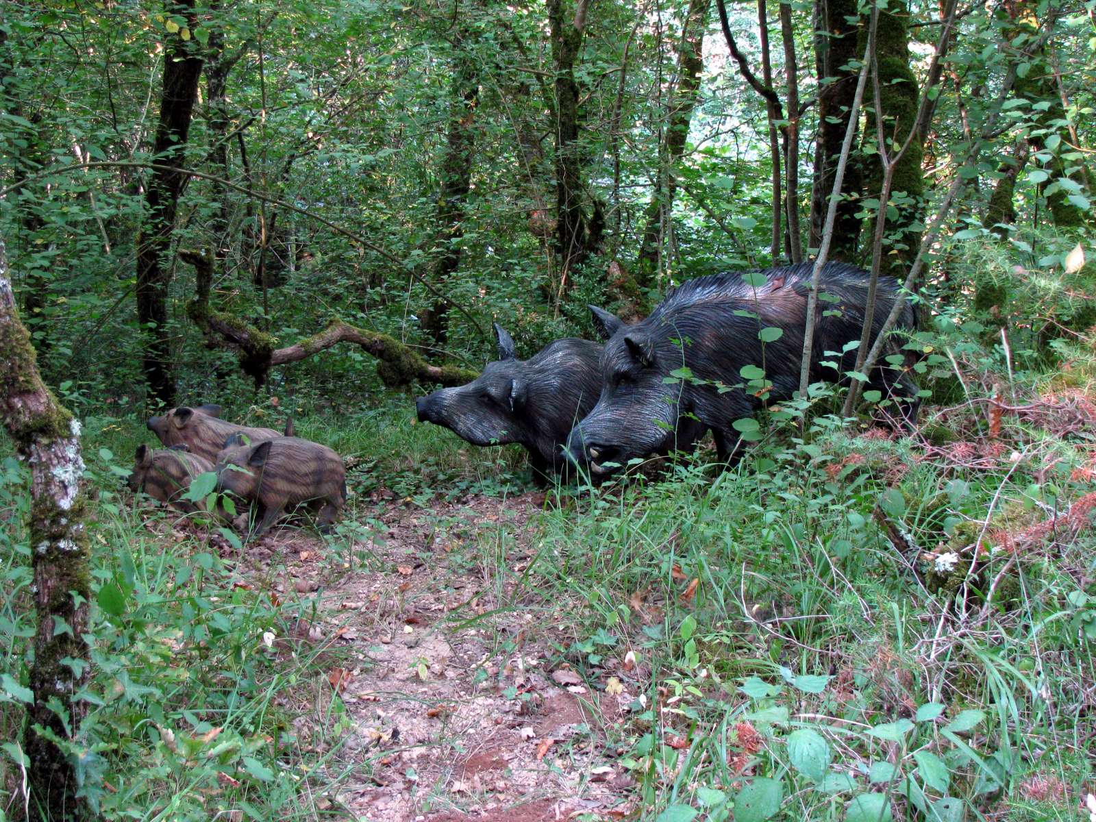
Wild pigs were a valued resource. They lived off fallen acorns of the oak forest when this was available, but pigs eat almost any kind of food, including dead insects, worms, trees, bark, garbage and even dead pigs.
Photo: Don Hitchcock 2008
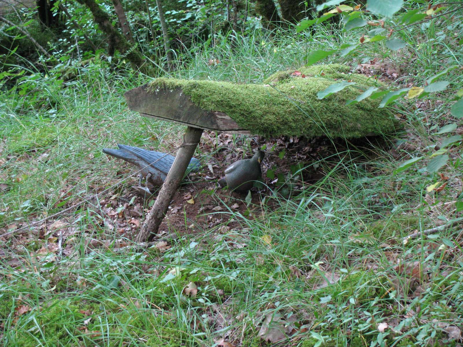
The trapper lays snares to catch rabbits and hares, leg traps to capture foxes and badgers, which must be very strong, as well as dead falls to catch birds, martens and weasels.
Photo: Don Hitchcock 2008
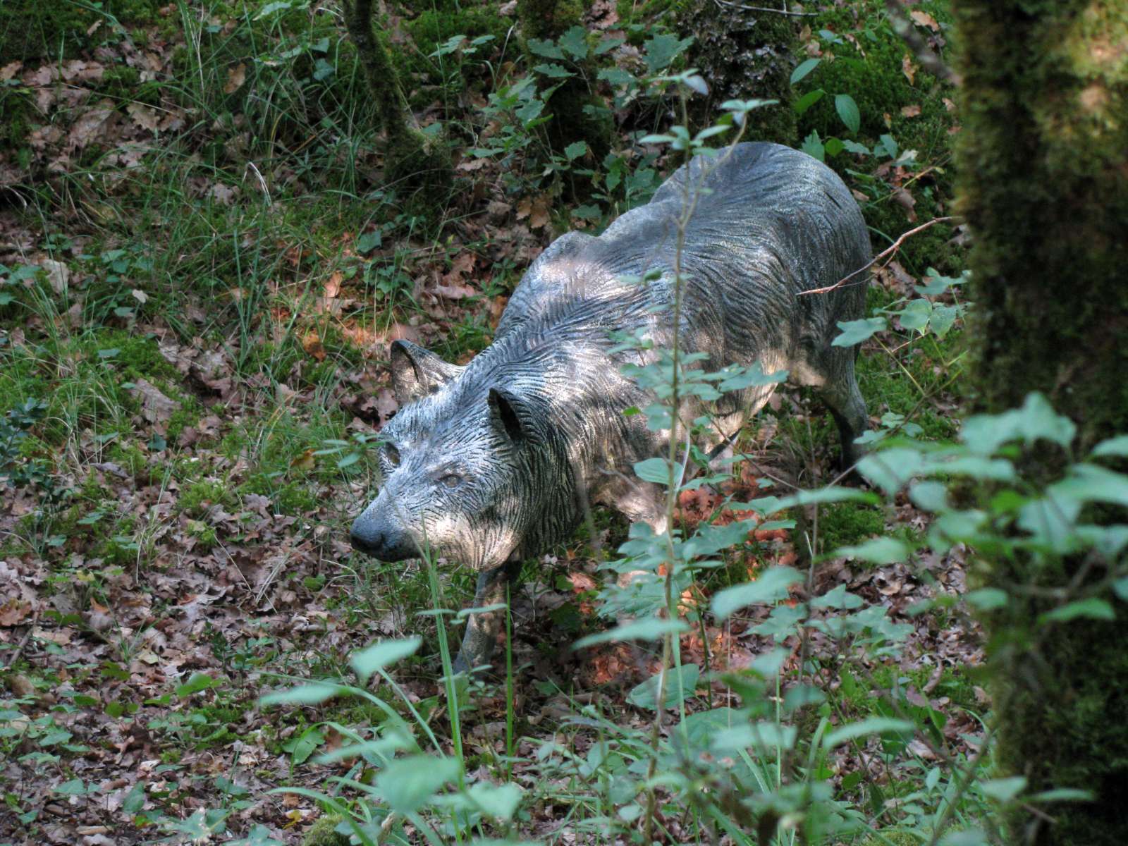
In the Perigord, the wolf was present throughout the Middle Ages and even later still, as the last specimen was killed in 1936 in the The Foret de la Double, 45 km from here. It covers about 50 000 hectares to the south-west of Perigueux, in the northern part of the Dordogne between the Dronne river and the Isle River. The forest is only sparsely inhabited, by smallholdings and houses scattered far and wide.
Photo: Don Hitchcock 2008

This quarry was used to extract some of the blocks necessary for the construction of the houses used in the Roc de Cazelle. The limestone of the valley of the Beune is still highly regarded.
Since the Egyptian and Greco Roman epochs to the last part of the twentieth century, the techniques of excavation and working the stone have not changed: the tools are the crowbar, the pick, the wedge, and the saw used in later times.
Quarries and mines have long constituted an economic sector of great importance, employing a large number of French people.
Photo: Don Hitchcock 2008
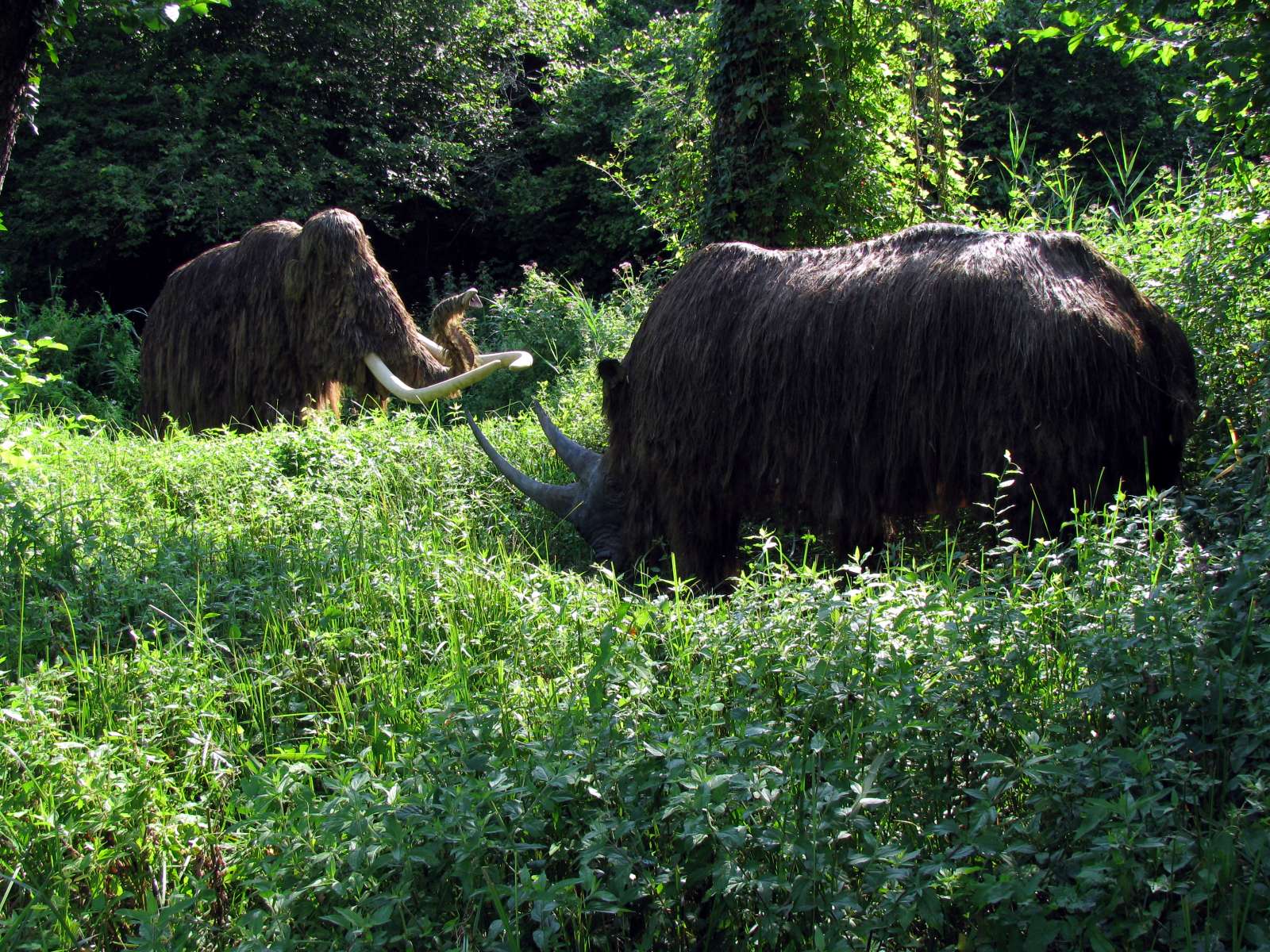
The hairy mammoth and the hairy rhinoceros were occasional visitors to the valleys of the Beune and the Vezere. Special techniques and weapons were necessary for a successful hunt, however.
Photo: Don Hitchcock 2008

Historically, men have had to fight the predators who come at night to make havoc in poultry houses.
With the invention of the crossbow, trappers could devise traps such as this one, where a piece of meat is suspended by a carefully balanced rod, which, when disturbed, shot a metal tipped bolt into the animal.
This has trapped foxes, badgers and wild dogs, and is particularly effective and deadly.
Photo: Don Hitchcock 2008
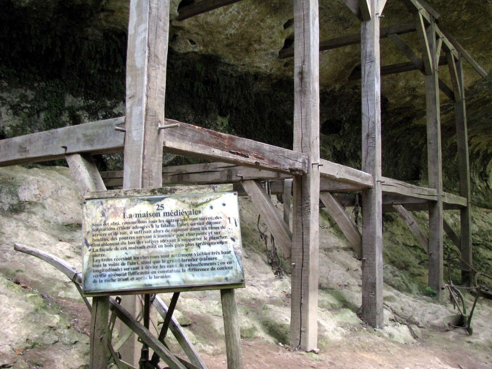
The Medieval House
Under this shelter, as in all the others that follow beside this path, houses were built against the cliff. The shelter used the rear wall and roof of the abri, it was enough to let bearers or beams into holes bored into the stone to support the structure and the joists for supporting the floor. The front of these houses was sheathed in wood, or later stone.
The holes for the rafters are clearly visible very high under the arch of the sheltering stone vault, as well as the large drip channel (longitudinal groove) to deflect water runoff, whose effectiveness can be easily verified by noting the difference in colour of the rock above and below the drip channel.
Photo: Don Hitchcock 2008

A Threshing Wheel
This slightly tapered stone was used on a threshing floor called in this region a sol.
Before the invention of the mechanical threshers, grain was threshed in two ways, either beaten with a flail, or pressed with a roller.
The sheaves of wheat were piled on the aire, or the threshing floor, heads running in the opposite direction of travel of the roller itself, which was pulled by oxen.
The straw was threshed by the trampling of animals and the passage of the roller and was then lifted with pitchforks, shaken, returned, and after a second passage, removed.
The grains then remained on the threshing floor, mixed with various debris (chaff, dust, straw) and had to be passed through the trieur (sorter)
Two oxen and six men could in a day thresh 2000 litres of grain.
The preparation of a sol was done either on a well groomed layer of clay , or on the rock itself if it was flat, or on a bed of sand and cow dung and dried straw.
Photo: Don Hitchcock 2008
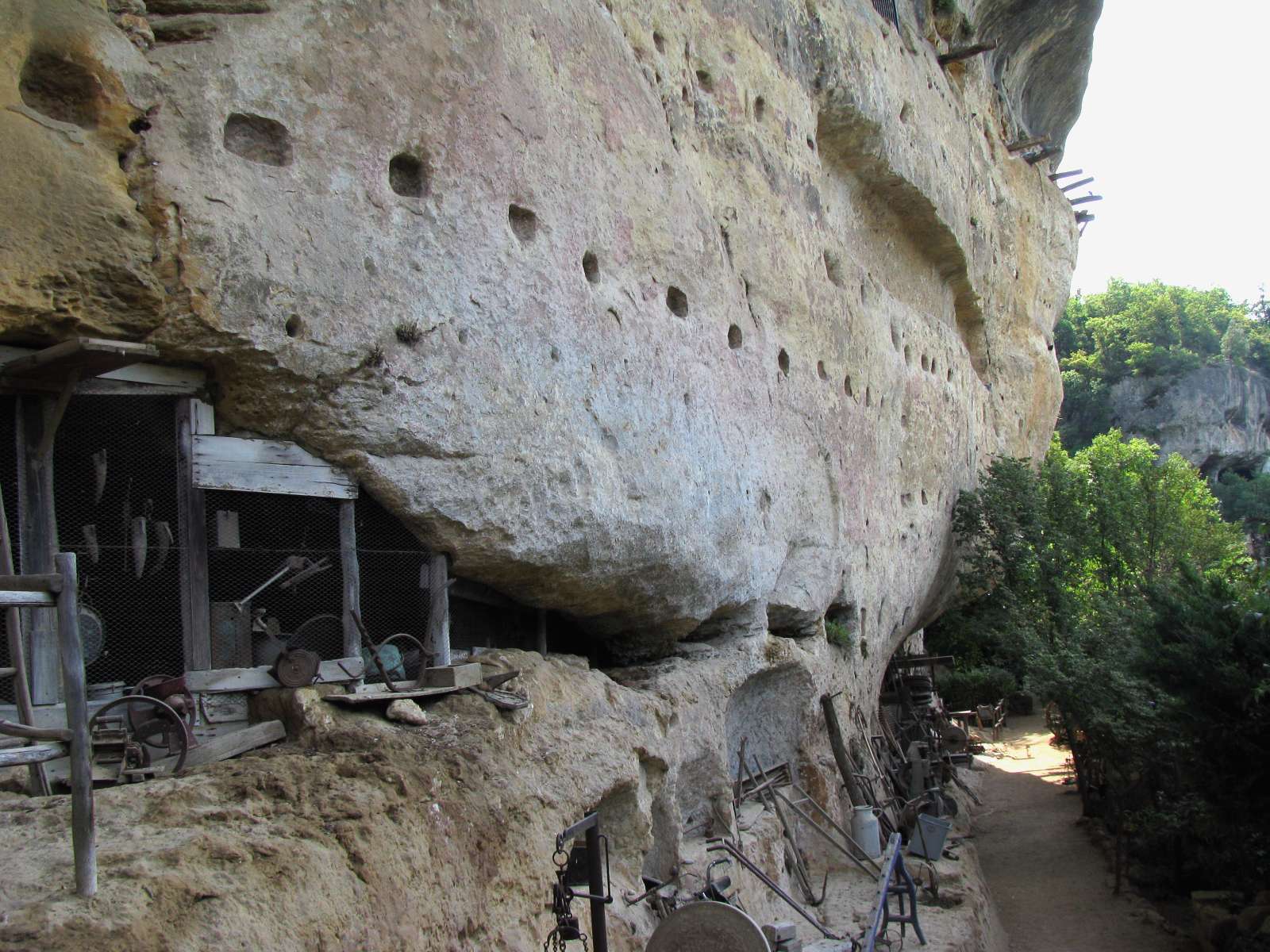
A display of old farm implements, and with the remains of holes and beams used for the houses which formerly were built here.
Photo: Don Hitchcock 2008
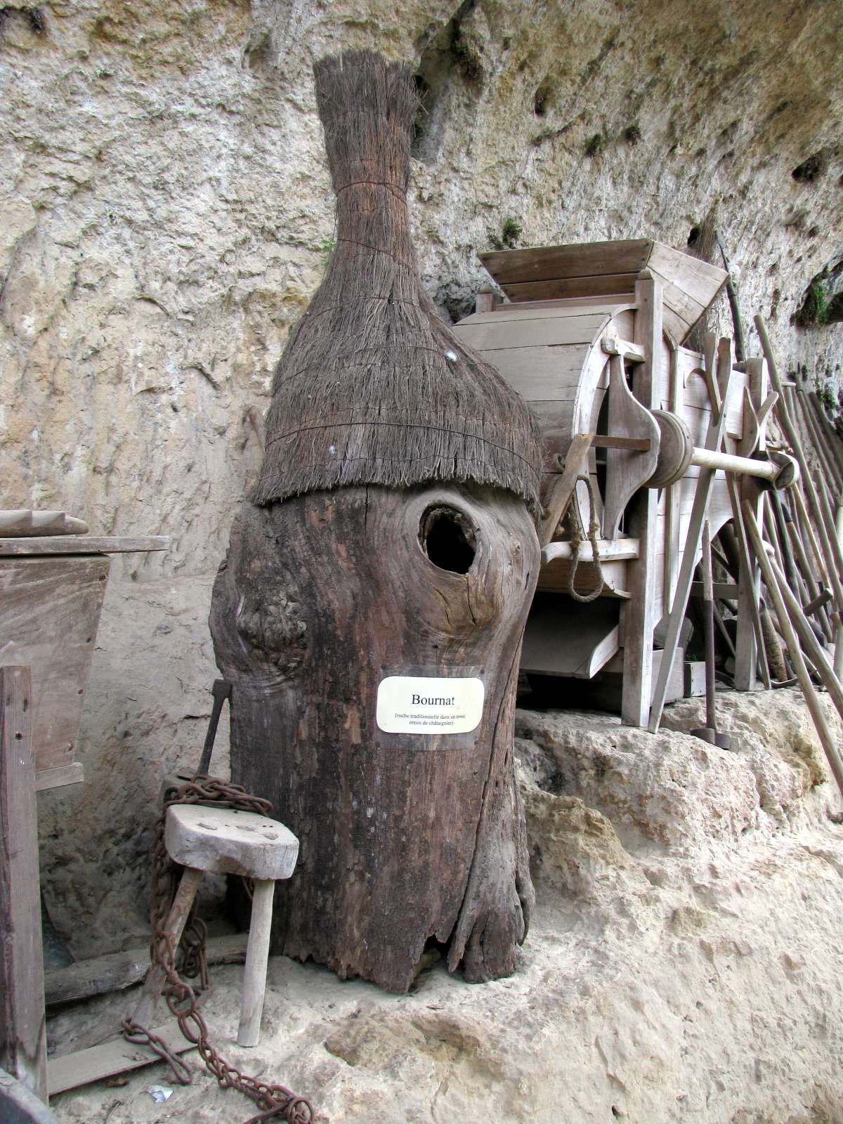
A Bournat, a traditional bee hive in a hollow chestnut log.
Photo: Don Hitchcock 2008

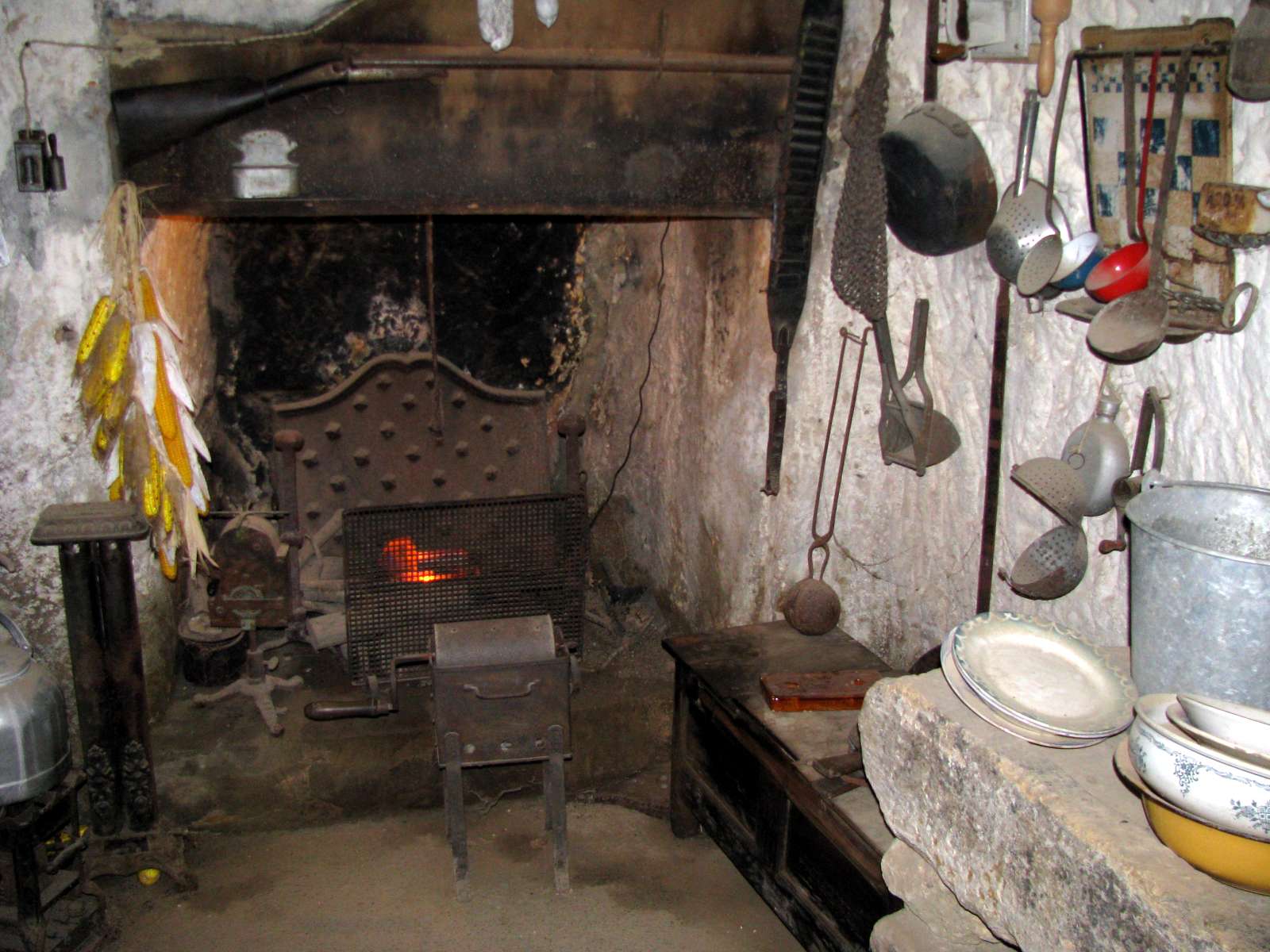
This farmhouse, cut from the rock to give a rectangular room, and fitted with a fireplace and chimney, was used until 1966, and is more or less as it was when last used.
We can see the old foot operated or treadle sewing machine, pots, ladles and dishes, all the paraphenalia of ordinary domestic life.
Photo: Don Hitchcock 2008
References
- Anderl, C. and Eifring, H., (eds) 2006, Studies in Chinese Language and Culture - Festschrift in Honour of Christoph Harbsmeier on the Occasion of His 60th Birthday, published by Hermes Academic Publishing, Oslo, 2006, xlvi + 474 pages, including 14 colour pictures, ISBN 82-8034-051-3.
- Barrière, C., et Sahly, A., 1964: Les empreintes humaines de Lascaux. Miscelanea en Homenaje al Abate Henri Breuil, t. I, PP. 173-180, Barcelone, 1964, Diputacion Prov. de Barcelona, Inst. Prehist., y Arqueologia
- Barrière, C., 1980: Le Grand Plafond de Rouffignac, Bulletin de la Société préhistorique française. 1980, tome 77, No.9. pp. 269-276
- Barrière, C., 1982: L'art pariétal de Rouffignac, Paris, Picard, Fondation Singer-Polignac, 208 p.
- Buisson, D., 1990: Les flûtes paléolithique d'Isturitz (Pyrénées-Atlantiques), Bulletin de la Société Préhistorique Française, Volume 87, Number 10-12, published by the Société préhistorique française, Paris, in French, 1990, pages 420-433. ISSN 0249-7638.
- D'Errico, F., Henshilwood C., Lawson, G., Vanhaeren, M., Tillier, A., Soressi, M., Bresson, F., Maureille, B., Nowell, A., Lakarra, J., Backwell, L., Julien, M.,., 2003: Archaeological Evidence for the Emergence of Language, Symbolism, and Music — An Alternative Multidisciplinary Perspective, Journal of World Prehistory, Volume 17, Number 1, published by Plenum Publishing Corporation, March 2003, pages 1-70.
- Duhard J., 1993: Étude comparative des statuettes féminines de Sireuil et Tursac (Dordogne), Bulletin de la Société Historique et Archéologique du Périgord, 77, p.55-64.
- Mair, H., 2006: Prehistoric European and East Asian Flutes, in Anderl et al (2006), pages 209-216.