Back to Don's Maps
 Back to Archaeological Sites
Russian, Ukrainian and Siberian Paleolithic sites - The Paleolithic of the former USSR

View of Dubovka - Beldzhamen
Photo: Arsave, via Panoramio
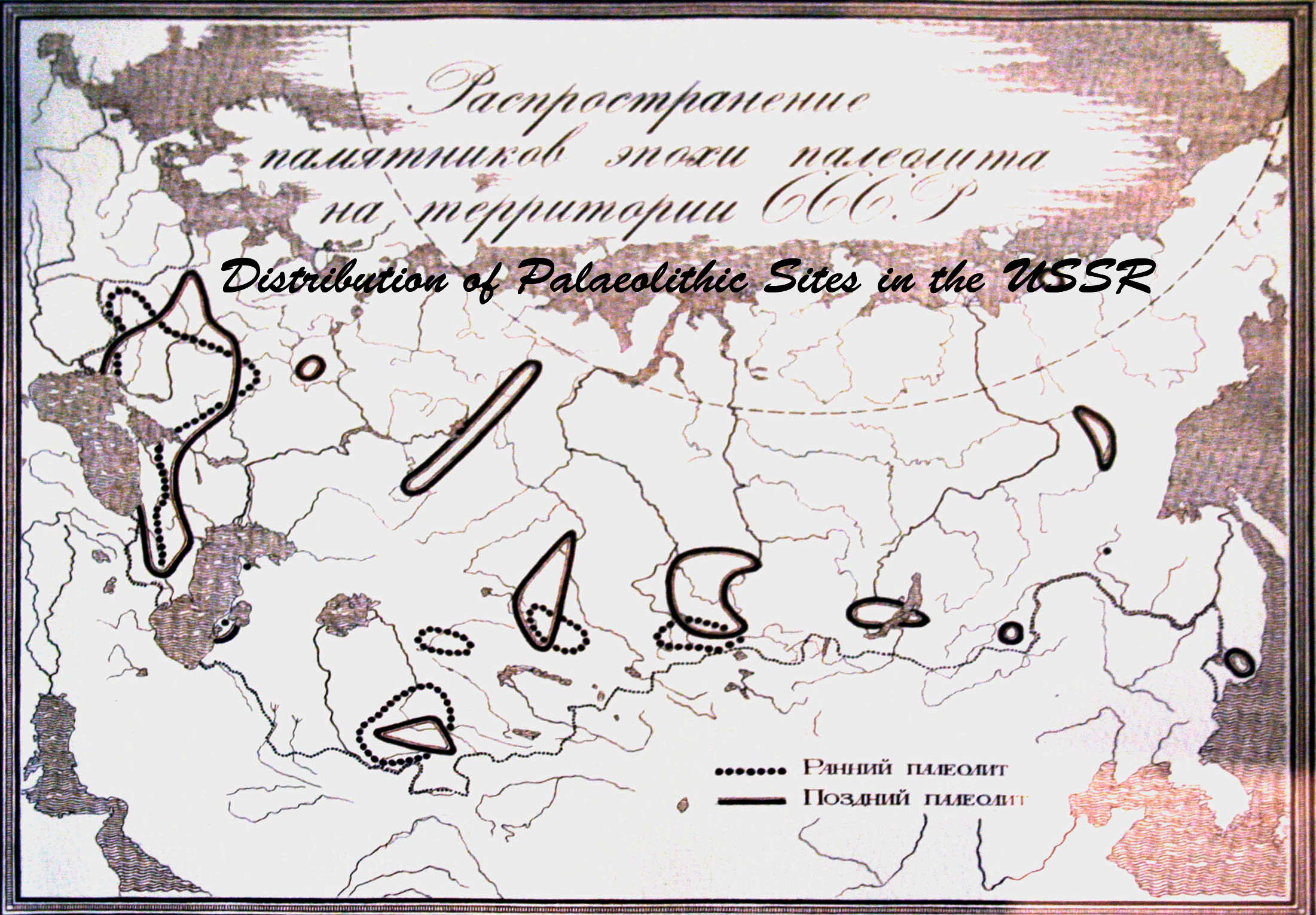
Distribution of Palaeolithic Sites in the USSR
Photo: Vladimir Gorodnjanski 2007
Source: The Hermitage Museum, Saint Petersburg
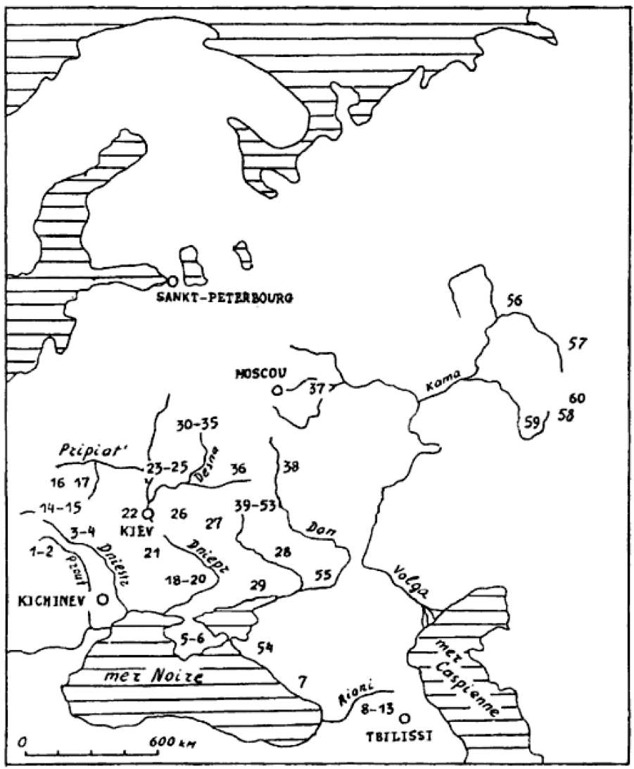
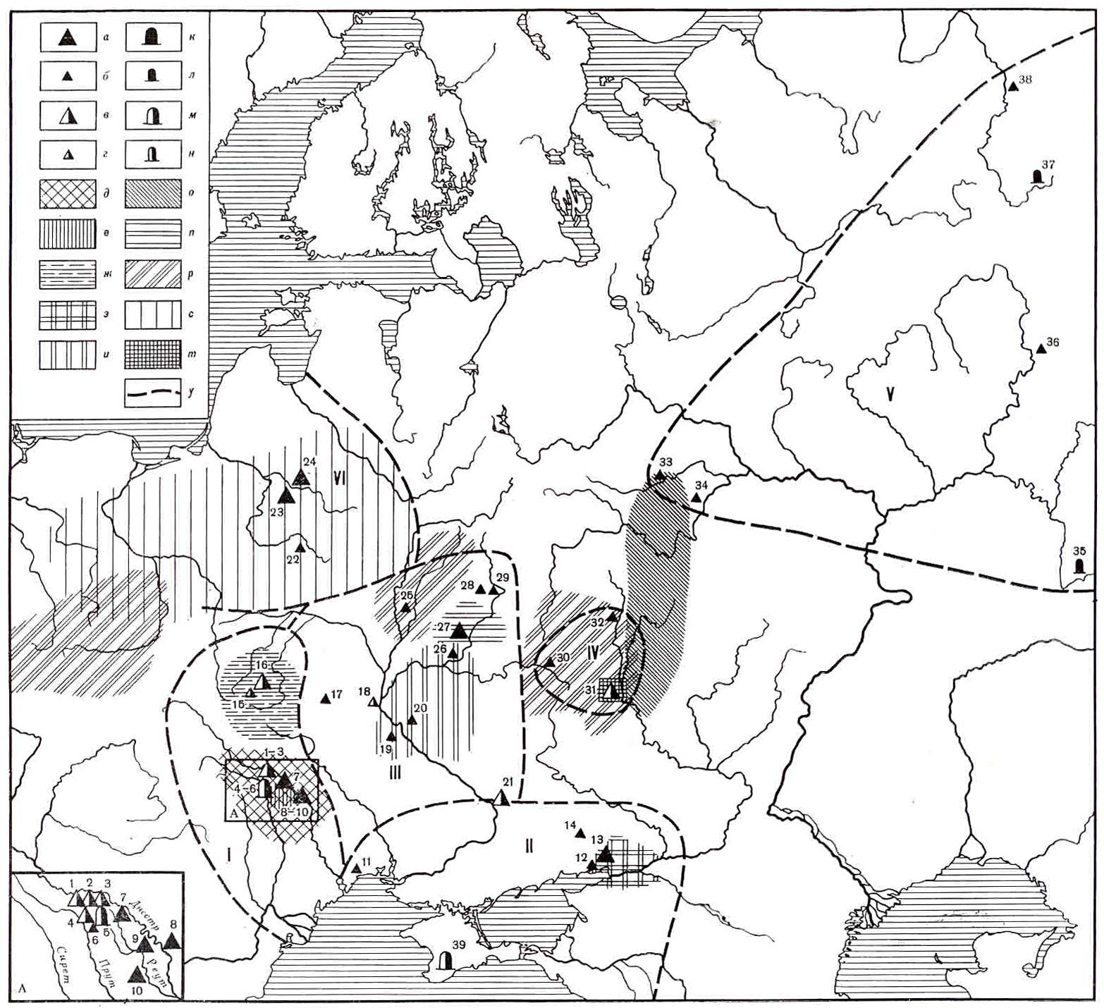
Distribution of mobile art in Eastern Europe.
1 Staryé Duruitory, 2 Brynzeny, 3 Kosseoutzy, 4 Klimaoutzy, 5 Suren' 1, 6 Chan-Koba, 7 Apiantcha, 8 grotte d'Uvarov, 9 Sakagia, 10 Sagvardgilé, 11 Gvardgilas-Kldé, 12 Devis-Khvreli, 13 Taro-Kldé, 14 Molodova V, 15 Lissitchniki, 16 Lipa VI, 17 Klinetz, 18 Ossokorovka, 19 Dubovaya Balka, 20 Kaïstrovaya Balka, 21 Mejiritch (Mezhirich), 22 Kievo-Kirillovskaya, 23 Mézine (Mezin), 24 Novgorod Severskyi, 25 Puchkari I, 26 Dobranitchevka, 27 Gontzy, 28, Rogalik, 29 Amvrossievka, 30 Eliseevitchi I, 31 Eliseevitchi II, 32 Yudinovo, 33 Khoylevo II, 34 Timonovka, 35 Suponevo, 36 Avdeevo, 37 Sungir', 38 Gagarino, 39 Kostienki 19, 40 Kostienki 21, 41 Kostienki 13, 42 Kostienki 1, 43 Kostienki 14, 44 Kostienki 12, 45 Kostienki 17, 46 Kostienki 2, 47 Kostienki 11, 48 Kostienki 4, 49 Kostienki 15, 50 Kostienki 9, 51 Kostienki 8, 52 Borchtchevo 1, 53 Borchtchevo 2, 54 Ilskaya, 55 Murakovka, 56 Ostrovskaya, 57 Bez'imyannyi, 58 Smelobskaya, 59 Kapova, 60 Ignatievskaya.
Photo: Abramova (1995)
Early Paleolithic of the Russian Plain
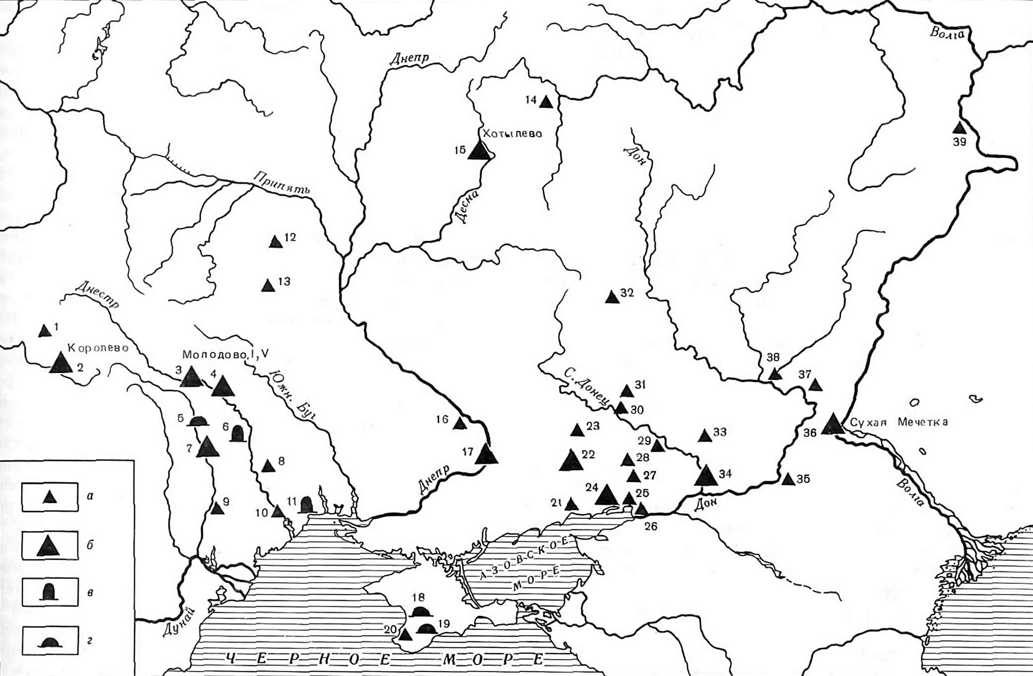
The main locations of the Early Paleolithic of the Russian Plain
Основные местонахождения раннего палеолита Русской равнины
Photo: Abramov et al. (1984)
a - single open air site - единичные местонахождения открытого типа
б - a group of open air sites - группы местонахождений открытого типа
в - individual sites of a rock shelter or cave type - единичные стоянки пещерного типа
г - a group of rock shelter or cave type sites - группы стоянок пещерного типа
- Onokovtsy, Goriani, Radwanska mountain (Radvanskaya gora) - Оно-ковцы, Горяны, Радванская гора
- Koroljovo, Rokosovo, Cherna - Королево, Рокосово, Черна
- Molodova V, Corman IV - Молодова V, Кормань IV
- Chetrosu, Stinka, Attacki IV. VII, and others - Кетросы, Стинка, Атаки IV. VII и др.
- Older Duruitory, Buteshty, Booz-duzhany - Старые Дуруиторы, Бутешты, Буз-дужаны
- Vyhvatiptsy - Выхватипцы
- Stary Kukoneshty, Mersyna - Старью Куконешты, Мерсына
- Tiraspol (Kolkotova balka, Kolkotova beam), Karagash - Тирасполь (Колкотова балка), Карагаш
- Vasiliki. Skuliany, German-Dumeny - Василика. Скуляны, Герман-Думены
- Bilhorod-Dnistrovskyi - Белгород-Днестровский
- Ilinka - Ильинка
- Richta - Рихта
- Zhitomirskoje - Житомирское
- Zolotariha - Золотариха
- Khotylevo I, Negotino, Betovo - Хотылево I, Неготино, Бетово
- Romankovo - Романково
- Orjol, Cruglik, Nenasyten, Kodak - Орел, Круглик, Ненасытен, Кодак
- Chokurcha, Volchiy Grot (Wolf Cave), Kiik-Koba, Shaitan-Koba, Starosels, Aji-Koba, Bach-chisarayskaya - Чокурча; Волчий Грот; Киик-Коба; Шайтан-Коба; Старосельс; Аджи-Коба; Бахчисарайская
- Za skal'niye i Ak-Kayskpy stoyanki. Prolom (For the rock and the Ak-Kayskpy sites. Prolom) - За скальные и Ак-Кайскпй стоянки. Пролом
- Sari-Kaya, Krasnaya balka - Сары-Кая, Красная балка
- Samsonovo, Obryv, Novoazovsk - Самсоново, Обрыв, Новоазовск
- Antonovka I-II Aleksandrovka, Petrovka. Maryanovka - Антоновка I—II; Александровка, Петровка. Марьяновка
- Makeyevka, Belokuzminovka, Zvanovka - Макеевка, Белокузьминовка, Звановка
- Rozok 1-11. Nosovo 1, Gerasimovka, Lovinsadovka, Beglica, Bokovo - Рожок 1—11. Носово 1. Герасимовка, Ловинсадовка, Беглица, Боково
- Bessergenovka - Бессергеновка
- Elizavetovca - Елизаветовка
- Matveyev Kurgan - Матвеев Курган
- Amvrosievka, Novoklinovka, Beloyarovka, Uspenka - Амвросиевка, Новоклиновка, Белояровка, Успенка
- Kamenek-Shakhtinsky - Каменек-Шахтинский
- Krasny Yar (Red Ravine) - Красный Яр
- Derkul - Деркул
- Dubovka - Дубовка
- Kalitvenka - Калитвенка
- Khryashi, Mikhailovsky, Konstantinovka - Хрящи, Михайловское, Константиновка
- Bol'shaya Kozlova balka, Tsiganskiy hootor (Big Ball Kozlov beam, Gypsy village) - Большая Козлова балка, Цыганский хутор
- Suzaya Mechetka 1-11, Pichuga - Сузая Мечетка 1—11, Пичуга
- Logovsky - Логовское
- Shakino (ustye Myedvyeditsy, mouth of Medveditsa) - Шакино (устье Медведицы)
- Krasnaya Glinka - Красная Глинка
Upper Paleolithic of the Russian Plain
Upper Paleolithic of the Russian Plain
Photo: Abramov et al. (1984)
Карта-схема зон распространения основных археологических культур и памятников позднего палеолита Русской равнины.
A schematic map of the main areas of distribution of archaeological cultures and sites of Upper Paleolithic of the Russian Plain.
А - sites of Dniester - Prut region - памятники - Днестровско-Прутского региона
a - a group of open air sites - группа стоянок открытою типа
б - single open air sites - одиночные стоянки открытого типа
в - a group of multi-layer open air sites - группа многослойных стоянок открытого типа
г - a single multi-layer open air site - одиночные многослойные стоянки открытого типа
д - Molodovskaya culture - молодовская культура; е - Brynzenskaya culture - брынзенская культура
ж - Lipska culture - липская культура
з - kamenno (stone) balkovskaja culture - каменно балковская культура
и - Mezin and Mezhirich-Dobranich culture - мезинская и межиричско-добраниченская культура
к - a group of cave sites - группа пещерных стоянок
л - single cave dwellings - одиночные пещерные стоянки
м - group of multilayer cave sites - группа многослойных пещерных стоянок
н - single multi-layered cave sites - одиночные многослойные пещерные стоянки
о - Streletko-Sungir culture - стрелецко-сунгирьская культура
n - Pushkarev Culture - пушкаревская культура
p - Willendorf - Kostenki culture - виллендорфско-костёнковская культура
с - Svider culture - свидерская культура
т- cultures known only within the Kostenki-Borshevo area (Spitsin - Gorodtsov - Zamyatin) - культуры известные только в пределах костенковско - борщёвского района (спицинская городцовская замятинская)
y - the approximate boundaries of the development of the late Paleolithic culture in Eastern Europe. - приблизительные границы областей своеобразного развития поздне-палеолитической культуры на территории Восточной Европы.
I - South -West Region - Юго-Западпая область
II - Southeastern Region (Steppe) - Юго-Восточная область (степная)
III - Dnipro - Поднепровье
IV - Main Don region - Среднее Подонье
V - Northeast region - Северо-Восточнап область
VI - Northwest Region - Северо-Западная область
1 - Voronovitsky group (Voronovitsa 1-5) - Вороновицкая группа (Вороновица 1 - 5) 2 - Babinsky group (Babin 1-11) - Бабинская группа (Бабин 1 - 11) 3 - Molodovsko Kormanskaya-group (Molodova 1-8 Corman 1-4) - Молодовско-Корманская группа (Молодова 1 - 8 Кормань 1 - 4) 4 - Korpachskaya Group - Корпачская группа 5 - Brynzenskaya group - Брынзенская группа 6 - Costesti I - Костешты I 7 - Atakskaya group (Attack 1-6) (?Otach' on the right bank of the Dniester River near the border with Ukraine?) - Атакская группа (Атаки 1 - 6) (?Отачь?) 8 - Rashkovsky group (Rashkov 1-8) - Рашковская группа (Рашков 1 - 8) 9 - Bobuleshtskaya group (Bobuleshty 1-6) - Бобулештская группа (Бобулешты 1 - 6) 10 - Chutuleshtskaya group (Chutuleshty 1-3) - Чутулештская группа (Чутулешты 1 - 3) 11 Bol'shaja Akkarzha - Большая Аккаржа 12 - Muralovka - Му-раловка 13 Kamenno (stone) balkovs'aja group - Каменно балковсьая группа 14 - Amvrosievka - Амвросиевка 15 - Kulichivka - Куличивка 16 - Lipska group (Lipa 1-6) - Липская группа (Липа 1 - 6) 17 - Radomyshl - Радомышль 18 - Kirillovskaja stojanka (St. Cyril's site) - Кирилловская стоянка 19 - Mezhiritch - Межиричи 20 - Dobranichevka - Добраничевка 21 Osokorovka Dubovaja balka (oak beam ) - Осокоровка Дубовая балка 22 - Site at Lake Svityaz - Стоянка у оз. Свитязь 23 - Ezhyarinas - Эжяринас 24 - Vilnius - Вильнюс 25 - Berdyzh - Бердыж 26 - Moesia - Мезии 27 - Pushkarevskaya group (Pushkary 1-8 Pogon (Epaulettes) Bugorok(Hill) - Пушкаревская группа (Пушкари 1 - 8 Погон Бугорок) 28 - Eliseevichy (Yeliseevichi) - Елисеевичи 29 - Suponevo Timonovka - Супонево Тимоновка 30 - Avdeevo - Авдеево 31 - group of sites in the Kostenki-Borshevo district - группа стоянок Костенковско-Боршевского района 32 - Gagarino - Гагарино; 33 - Sungir - Сунгирь 34 - Karacharovsky site - Карачаровская стоянка 35 - Kapova Cave - Каповая пещера 36 - Ostrovskaya site. MV Talitsky - Островская стоянка им. М. В. Талицкиого 37 - Medvezh'ja peshhera (Bear's Cave) - Медвежья пещера 38 - Byzov site - Бызовая стоянка 39 - Syuren 1,2 - Сюрень 1,2
Text: Abramov et al. (1984)
Palaeolithic sites in Siberia and the Far East

Map of Palaeolithic sites in Siberia and the Far East
Карта палеолитических памятников Сибири и Дальнего Востока
Photo: Abramov et al. (1984)
а - Early Paleolithic open air sites. large symbols - a group of sites; small symbols - individual sites
б - Early Paleolithic cave or grotto, large symbols - a group of sites; small symbols - individual sites
в- Late Paleolithic open air sites, large symbols - a group of sites; small symbols - individual sites
г – Late Paleolithic caves or grottoes
д- afontovskaya culture
е- kokorevskaya culture
ж- Diuktai culture
з - the Maltese-buretskaya culture
и - direction of cultural ties
а - раннепалеолитические стоянки открытого типа; крупные зпаки — группы памятников; мелкие знаки — единичные памятники
б - раннепалеолитические пещеры или гроты; крупные знаки — группы памятников; мелкие знаки — единичные памятники
в - позднепалеолитические стоянки открытого типа; крупные знаки — группы памятников; мелкие знаки — единичные памятники
г - позднепалеолитические пещеры или гроты
д - афонтовская культура
е - кокорев-ская культура
ж - дюктайская культура
з - мальтийско-буретская культура
и - направление культурных связей

Close up of Palaeolithic sites in Siberia, with particular emphasis on the cultural ties in this central and important area.
Photo: Abramov et al. (1984)
- Mysovaya - Мысовая
- Shikaevka - Шикаевка
- Cherpoozere - Черпоозёрье
- Volch'ya Griva (Wolf Mane) - Волчья Грива
- Pyeshshyera Strashnaya (horrible cave) - пещера Страшная
- Pyeshshyera Oost'-Kanskaya (Ust-Kan cave) - пещера Усть-Канская
- Dyenisova pyeshshyera (Denisova Cave) - Денисова пещера
- Tuekta -Туэкта
- Ulalinka - Улалинка
- Srostki - Сростки
- Tomsk - Томская
- Mogochino - Могочино
- Achinskaya - Ачинская
- Malaya Siya (Small Syya) - Малая Сыя
- Saglam - Саглы
- Ching-Doug-uzhu - Чинге-Даг-Ужу
- Shagonar - Шагонар
- Khemchik - Хемчик
- Ooloog-Byook, Porog 1 (Ulug-Buck, threshold 1) - Улуг-Бюк, Порог 1
- Demir-Sug - Демир-Суг
- Kan-tegir - Кан-тегир
- Goloobaya (Blue) - Голубая
- Dvooglazka (Two-eyes) - Двуглазка
- Tashtyk - Таштык
- Kokorev - Ко-корево
- Novoselovo - Новоселово
- Afontova Gora (Afontova hill) - Афонтова Гора
- Druzhiniha - Дружи-ниха
- Mal'ta - Мальта
- Sosnoviy Bor (Pine forest) Сосновый Бор
- Vyerholyenskaya Gora (Verkhoyansk Mountain) - Верхоленская Гора
- Buret' - Буреть
- Gora Glinyanaya i dr. (Mount Clay and others) Гора Глиняная и др.
- Gora Sta-raya i dr. (Mountain Old and others) - Гора Ста-рая и Др.
- Igeteysky log - Игетейский Лог
- Krasniy Yar (Red Ravine) - Красный Яр
- Fedyaeva - Фе-дяево
- Bratsk - Братск
- Ust-Kova - Усть-Кова
- Ust-Kyakhta - Усть-Кяхта
- Zarubino - Зарубило
- Nyangi, Nomohonovo - Няньги, Номохоново
- Oshurkova - Ошурково
- Варварина гора (Varvara Mountain)
- Sanniy Mis (Sled Cape) - Санный Мыс
- Stoodyenoye (Glacial) - Студеное
- Tol-baga - Тол-бага
- Kupaley - Купалей
- Sohatino - Сохатино
- Ikaral - Икарал
- Makarov - Мака-рове
- Chastinskaya - Частинская
- Avdeiha - Авдеиха
- Dyooktayskaya pye-shchyera (Diuktai Cave) - Дюктайская пе-щера
- Verhnetroitskaya - Верхнетроицкая
- Ezhantsy - Эжанцы
- Ihine - Ихине
- Berelekh - Берелех
- Ushkovskiye stoyanki (Ushkovsky sites) - Ушковские стоянки
- Kumara - Кумары
- Filimoshki - Фили-мошки
- Osinovka - Осиновка
- pyeshchyera Gyeografichyeskovo obshchyest-va (Cave of the Geographical Society) - пещера Географического общест-ва
- Ustinovka - Устиновка
Text: Abramov et al. (1984)
Early Paleolithic of the Caucasus

Early Paleolithic of the Caucasus
Photo: Abramov et al. (1984)
- a - Mousterian location and sites - мустьерские местонахождения и стоянки
- б- Acheulean location - ашельские местонахождения
- в - Cave sites - пещерные стоянки
Text: Abramov et al. (1984)
1. Caucasus - one of the main areas of primary settlement in our country the oldest man, an area of high concentration of sites of the Lower Paleolithic. The abundance, nature and characteristics of these archaeological sites in the Caucasian region is closely related to the geographical position of this region, its natural conditions, Quaternary history and proximity to the anterior ancient Asian Palaeolithic world.
2. Historiographical introduction. The first search for traces of the Stone Age in the Caucasus have been made over a hundred years ago in connection with the preparation of the Archaeological Congress in Tbilisi in 1881, starting overseas study of the Palaeolithic to the Caucasus is considered, however, in 1898, when French scholar Joseph de Bai discovered in the North Caucasus Ilskuyu Mousterian site near Krasnodar. The discovery of the Palaeolithic to the south of the Caucasus mountain range was a little later, during a visit of French explorer Jacques de Morgan in Armenia. On the western slope of Mount Aragats stone tools were collected, referred by them as a whole to the Upper Palaeolithic, although as outlined, there were some Mousterian forms (Morgan, 1909).
3. By 1917, the Lower Palaeolithic of the Caucasus was one of the least developed parts of the primitive archeology of the area. Information about the Acheulian era was absent, scarce Mousterian materials (Il'sky, Aragats) were not preserved, and they had lost almost all scientific value. In essence, Soviet archaeologists were forced to start the search and study of the Lower Paleolithic again.
4. Soviet archaeologists work on the study of the Lower Paleolithic of the Caucasus can be divided into four main stages.
5. The first, covering the period up to 1934, was characterised by studying the previously known sites. In 1925 SN Zamyatnin reopened and resumed the study of Il'sky archaeological site (1925, 1926, 1928).
6. The second phase, which includes 6 - 7 pre-war years (1934-1941.) Indicates the formation of Soviet Palaeolithic kavkazovedcheskoy science, expressed primarily in the broad deployment of specialised reconnaissance of large areas. Systematic search of work covered in these years, the Caucasian Black Sea and Kuban in part. In Sochi, the Black Sea region Abkhazia was found first in the country Acheulean sites (Yashtuh, Guardi, Byrts, etc.), the first location in the Caucasus Mousterian (Host, Lech-cop, Escher, Kelasuri, Ochamchire, etc.) and Mousterian cave dwellings with an undisturbed cultural layer (Ahshtyrskaya, Pavalishenskaya, Atsinskaya, Vorontsovskaya Hosta I and II) Zamyatnin S., (in 1936 and 1937, the same site unearthed by VA Gorodtsov.) 1937, 1940, 1950, 4961; Panichkin M. 3., 1940; Krainov, DD, 1947. In the Kuban were discovered Lower Palaeolithic location Fortenyanka and others (SY Zamyatin, 1949).
7. The third stage is the first postwar decade. A qualitatively new development here was the involvement in the study sites and the problems of early Palaeolithic specialists, who grew up in the Caucasian national research centres. The main achievements of this period were: the discovery of two new major areas of concentration Acheulian and Mousterian sites - in Armenia (Zamyatin SY, 1947; Panichkin M. 3., 1950; Sardaryan SA, 1954) and in South Ossetia (in Lubin Ya., 1954, 1958, 1960a) and a new group of lower Palaeolithic sites in the Kuban area (SY Zamyatin, 1949, 1950; Formozov AA, 1952).
8. In 1955 begins the fourth and last stage, the most significant of the scientific results. It is opened by the discovery of four multi-mountain cave sites with undisturbed Acheulian cultural layers. These are - Kudaro I (1955), Kudaro III (1957) and Tsona (1958) in the South Ossetian Autonomous Oblast of the Georgian SSR and Azykh (1960) in Azerbaijan (in Lubin, J., 1959 , 1969a; Lubin VL Levkovskaya GM, 1972, and A. Kalandadze, 1965; Museib MA, MM Guseinov, 1961; Guseinov A /., 1965). In the same period were excavated dozens of new and previously known Mousterian cave sites in Georgia, Armenia, Azerbaijan, Black Sea and Prikubaie (Zamyatin SY, 1961 MM Guseinov, 1959, 1973a; Korobkov and J. ., 1962; Grigolia GK, 1963 Tushabramishvili DM, 1963a, b; Berdzenishvili NZ, 1964, outlaw William H., 1964, 1973; Panichkin M. 3., VekilovaE. A. , 1962 E. Vekilov, A., 1967, 1973; Kalandadze AN, 1969 Yeritsyan BG, 1970, 1975, Lubin VP Soloviev, LP, 1971 Nioradze MG , 1976; Lubin, VP, 1977a; Jafarov AK, 1978a, b, etc.) and have been identified and examined hundreds of angels and the Mousterian localities in various parts of the Caucasus. Among them is the large group of Lower Palaeolithic localities in the Kuban region (Outlaw PW, 1963 Formozov AA, 1965), in the Black Sea (Korobkov MI, 1967, 1971; Gumilevsky NY, Korobkov I. J., 1967 Schelinsky VE Ostrovskii, AV, 1970 Lubin VP Schelinsky VE, 1972; Berdzenishvili VZ, 1979; Grigolia GK, 1979, etc .), in Imereti (Tushabramishvili DM, 1962), in South Ossetia (Lubin, VP, 1960a, 1977a), Armenia (Lubin, VP, 1961), in Javakheti (Grigolia GK ., 1965), in Kakheti (Bugianishvili T., 1969, 1979), in zapadpom Azerbaijan (Mansurov M., 1965, 1978) and others.
9. To date, the lower Palaeolithic is found in all areas of the Caucasus mountain country: the Greater Caucasus (up to the highlands of the zone), and in many places in the Transcaucasian intermountain depression, in the Lesser Caucasus and the Armenian volcanic plateau as shown in the map above. Important features of the postwar stages of research are: monographic edition of materials selected sites (Grigolia GK, 1963, outlaw William P., 1963 N. Berdzenishvili 3., 1964), synthesis, accumulated both within the individual regions of the Caucasus (Panichkin M, 3., 1950; Sardarian S. A,., 1954; Formozov AA, 1965, Lubin, VP, 1960a, 19696), and the entire Caucasus (Lubin, VP, 1969a, 1977a), and the widespread involvement of representatives of the research sites natural sciences (Lubin VP Kolbutov AD, 1961, Lubin B. J., Burchak-Abramovich NI Klapchuk MN, 1971; Lubin, VP and GM Levkovskaya , 1972; Lubin VP, Outlaw William P., Grichuk VP, et al, 1973; in Lubin, P., Rengarten NV and others, 1978; Lubin VP Selivanova, IB et al, 1978; Gabunia MK, Tushabramishvili DM, AK Vekua, 1961; Grichuk VP Gubonin 3. P. et al, 1970; SchelinskiyV. E., Ostrovsky, AB, 1970; Vekua AK, Mamatsashvili YS, T-ushabramishvi a DM, 1973 Vekilova EA, Grichuk VY and others, 1978 ; Nioradze MG, AK Vekua et al, 1978; Maruashvili LI, Mamatsashvili NS et al, 1978).
The geography of the Caucasus has an extremely wide variety of environmental conditions. To understand the Palaeolithic of the Caucasus, to a much greater extent than for understanding the Palaeolithic of other vast regions of our country, we must take into account this diversity, and this is due to present a brief geographical introduction
Text: Abramov et al. (1984)
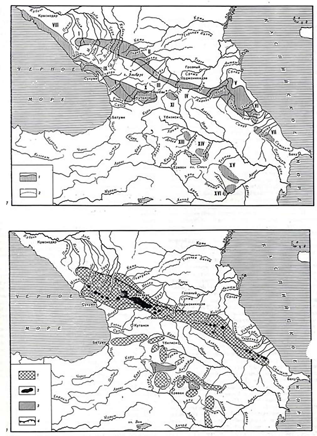
Geographical areas of the Caucasus.
A schematic map of the location of limestone- karstic areas of the Greater and Lesser Caucasus Mountains. After IA 'Gvozdetskii (1968-1972)
Upper map:
1 - Known boundaries of karst regions
2 - Estimated boundaries of karst areas
I - array - Fisht Oshten-Lagopaki in Montenegro; II - the western part of the cuesta band ; III - the eastern part of the cuesta band ; IV - Transition Region 'cuesta-fold' as for the Andean mountain range; V - a limestone region of internal Dagestan ; VI - limestone-karst region of southeastern Dagestan; VII - cave area of Shahdag; VIII - the north-western region of the Black Sea coast; IX - Sochi -Abkhaz region; X - West Georgia area; XI - on the Dividing Range; XII - the northern slope of the western Caucasus; XIII - Western region of Azerbaijan; XIV - Dashkeskanskaya area; XV - Tutgunchay-Shusha region; XVI - Zangelayao-Fizullinskaya area.
Lower map:
Paleogeographic scheme of Pleistocene glaciation of the Caucasus (After IV Dumitrashko, 1977).
1 - Development of Pleistocene mountain-valley glaciation (with a maximum spread in the late Pleistocene), 2 - modern glaciation, 3 - large lake basins, 4 - Rocky Range escarpment, after Dumetrashko NV, Milanovskiy EE, Balian S. P ., SayadyanYu. V., 1977).
Photo: Abramov et al. (1984)
For the maps above, the borders of the Caucasus in the north and south are not natural physical and geographical boundaries, as on both sides of their zone there is no sharp distinction. The openness of the Caucasian isthmus to the north and south of the Caucasus and the closure of the West or Southwest Asia, part of which it is played an important role in the initial population of Caucasian man and his relationship with the ancient population of the neighbouring territories.
10. The major elements considered related to mountain building are the Pre-Caucasus plains and the Caucasus mountain country. Pre-Caucasus areas include the steppe zone of the European part of the USSR, representing the southern part of the Russian Plain. The Caucasus is the mountainous country of the central and southern part of the isthmus and is divided into the Greater Caucasus, the Transcaucasian depression and Transcaucasian Highland.
11. The Greater Caucasus is the mighty mountain range which extends across the Caucasian isthmus. Its length is about 1100 km, width up to 180 km. In the axial zone of raised ridges there are peaks over 5 000 m
12. Along its length the Great Caucasus is divided into three segments: the Western, Central and Eastern, for which the boundaries between sections are those passing through Mount Elbrus and Kazbek. The Central Caucasus is the highest and coldest. In the West we sometimes delineate the Black Sea Forest Caucasus (medium altitude mountains in the area from Anapa to Sochi) and Abkhaz (Abkhaz-Kuban, or from Sochi to Mount Elbrus).
13. Transcaucasian Depression - An area of intermountain basins separating the Greater Caucasus and the Transcaucasian Highland. The western part is the Rioni basin (Colchis Lowland), the eastern - Kura Basin. Between them is a midland Surami (Likhi) range, which is the most elevated portion of depression.
14. Transcaucasian highlands - a small, northern section, located within the anterior portion of our country's Asian highlands. From the north it limits the area of kurorionskih basins in the south - p. Arak. The major elements of mountainous Highlands are the mountain ranges of the Lesser Caucasus, the Armenian volcanic plateau, Priaraksinskie ridges and mid-Araks basin.
15. Lesser Caucasus - a system of ridges bordering the Armenian plateau to the north and north-east (Ajara-Imereti ranges, Trialet, Somhetsky, Karabakh, etc.).
16. The Armenian volcanic plateau occupies the central part of the Transcaucasian Highland. Within the Armenian Plateau is Southern Georgia (Javakheti) and Central Georgia (actually Armenian). The highlands are distinguished by the extensive development of lava rocks, high elevation (1500 - 3000 m), fairly rugged, arid and continental. In the south-east of Armyanskoe Highland Group Priaraksinskih there are ranges (Zangezur, etc.) to the south, along the border - a chain of Middle basins with flat terrain (Ararat, Nakhichevan. Ordubad). The left-bank part of these basins, and other elements of the Transcaucasian highlands falls within Turkey or Iran (Gvozdetskii JA, 1948, 1963, Antonov, BA, Gvozdetskii JA, 1977).
17. The exceptional diversity of climate of the Caucasus is determined mainly by the influence of topography. Key climate zones due to altitude pass along the crest of the Greater Caucasus and Transcaucasus transverse uplift to the head. Climate zones due to altitude significantly affect the distribution of heat and moisture within the isthmus. The Greater Caucasus distinguishes two climatic zones: temperate and subtropical (North Caucasus belongs to the temperate zone, the Caucasus to the subtropical). Mountains divide the territory and the uplift of the mountainous regions of the Caucasus gives rise to a lot of areas with local peculiarities of climate, which leads to an exceptional diversity of habitats, and exceptional diversity of flora and fauna. The number of plant species in the Caucasus is more than 6000 (wheras the vast territory of the European part of the USSR only has 3500), and there are 130 species of mammals. Particularly rich in species are the forests which grow in Colchis, and in these forests grow a lot of wild edible plants (nuts, fruit, vegetables, etc.) (Grosgeym AA, 1942, 1952). The favourable climate and abundant food resources of Colchis, judging by the accumulation of Palaeolithic sites especially attracted primitive people to this area. Colchis was probably the safest haven of fauna, flora and humans during glaciations (Lubin B. J., 1969a, 1974).
18. For the manufacture of stone tools Palaeolithic people found in the Caucasus abundant raw material. Their use of the rock is extremely varied and at the same time there are some territorial differences in the use of sedimentary and volcanic rocks. Thus, in the middle part of the Caucasus Isthmus, in the zone of tectonic uplift of the Trans-meridian (the territory of North and South Ossetia, Javakheti and Armenia), in which there are numerous faults and lava flows, are completely dominated by the Acheulean and Mousterian industries, based on the lava rocks (andesites, basalts , obsidian). The major Acheulian-Mousterian work sites and archaeological sites, quarries are found directly on the outputs of the lava rocks in areas of particularly powerful manifestation of magmatism (Armenia, Javakheti). These are the Satani-Dar, Dzhraber, Fountain in the Ararat valley, the northern foot of the Wet Mountains in Javakheti. To the west and east of the named area (in Colchis, Black Sea, Kuban region, Dagestan, Azerbaijan) is dominated by flint and other sedimentary rocks.
19. Note also that in ashelskoe, people often used rough and tough boulder material, large pebbles, pieces of various siliceous and volcanic rocks (Azykh, Tsona, Kudaro, Lashe-Balta, Yukari-Salahli, etc.). In the absence of a sufficient number of high quality raw materials such material was used in part by the Mousterian people (Tsopi, Azykh, Kudaro). In some places, siliceous shales and limestones and mudstones are widely used (Kudaro, Tsona, Dzhruchula, Taghlar).
20. Siting of early Paleolithic settlements is in connection with fossilisation conditions and paleogeography. Mapping early Paleolithic sites shows a strong imbalance in the ancient people of the western and eastern half of the Caucasian isthmus, with a discrepancy in the population of the plains, foothills and mountainous areas, a rare occurrence in this area stands in the open air with undisturbed cultural layer. This picture reflects not only the state of our knowledge, in particular, and fossilised burials of Palaeolithic remains in mountainous country and the events in the past of the Quaternary of the Caucasian region.
21. Fossilisation circumstances (and severe erosion) are not conducive to the preservation and discovery of palaeolithic sites in the open. There are particularly poorly preserved traces of Acheulian and Mousterian people in the band of medium and high mountains. Deep in the mountains of the Greater Caucasus, for example, are known only scarce early Palaeolithic finds in South Ossetia (and Uchelet Fasrag location at an altitude of 1600-1800 m) and Imeretia (DM Tushabramnshvili on the slopes of the ridge and Racha passes). There are isolated finds in the same location in lowland areas (for example, finds of A, A. Formozov, Giray near the town of Kropotkin). The overwhelming majority of early Palaeolithic localities situated in the low foothills and adjacent areas of depression, involved in the area of the last Greater Doming and Lesser Caucasus Mountains. These are the location of the northern foothills of the Greater Caucasus, the location of the foothills of the southern slope of the Western and Central Caucasus, the location of the northern foothills of the Lesser Caucasus and foothill areas of Ganja-Kazakh sloping plain in western Azerbaijan. In the region of the Armenian volcanic highland locations are located mainly in the areas of intermontane depressions - basins.
22. VM Muratov (1969a), has searched for the geological and geomorphological features of Acheulian localities in the Kuban region, and said that these last are confined to the area of sustainable Quaternary uplift of a very small amplitude: they reach a narrow band, capturing the highest part of the Kuban sloping plains and low foothills. North of this band, they are probably buried under a thick layer of new continental sediments, south in the mountainous areas these could be destroyed by the intense slope washout.
23. On the slopes of the Greater Caucasus, Colchis Acheulean and Mousterian sites (including caves) are known in the mountains up to the subalpine belt of the mountain-meadow zone, to an altitude of 1600-2100 m above sea level (locations of the cave Uchelet Tsona and Kudaro in South Ossetia 15-20 km from the Dividing Range, while on the northern slope of the Mousterian and Acheulean finds marked no higher than the altitude of 1000 m (location north Jurassic depression in Karachaevo-Cherkessia, 60-70 km from the Dividing Range .)
25. There are differences in the extent of the penetration depth of the ancient people into the mountains of the southern and northern slopes of the Greater Caucasus, but it seems to be explained by glaciologica factors: the Pleistocene glaciation emerged most powerfully on the northern slope, especially in its central part. During the penultimate glaciation and maximum phase of the last glaciation (the Terek and bezingiyskogo by EE Milanovskiy) lobes penetrated to the north Jurassic depression here and there, through the Rocky Mountains gorges, moving north of the latter (Dumitrashko PV, Milanovskiy E. E., 1977)
Text: Abramov et al. (1984)
Late Paleolithic of the Caucasus
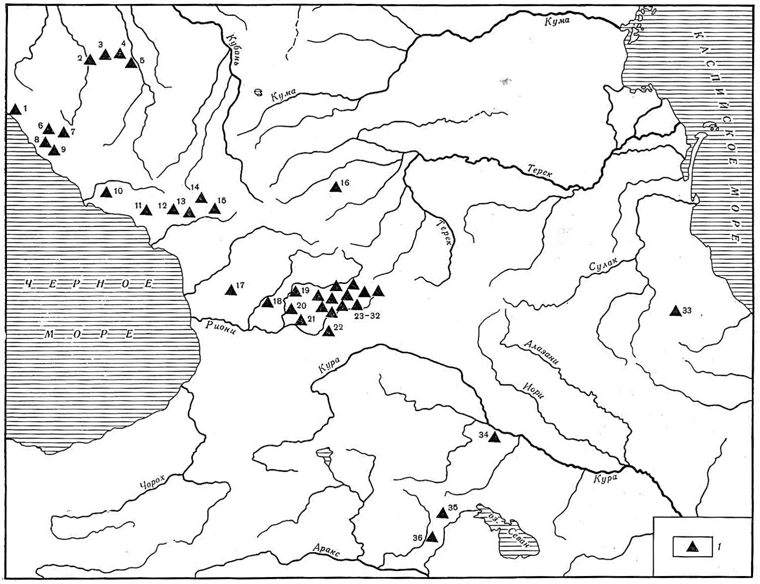
Карта основных позднепалеолитических памятников Кавказа
Photo: Abramov et al. (1984)
Late Paleolithic sites - позднепалеолптпческие памятники
1 - Shirokij mys (Large Cape) - Широкий мыс 2 Kamennomostskaja Peshhera (Cave) - Каменномостская пещера 3 - Gubskpj Naves (Shelter) - Губскпй навес 4 - Satanaj Naves (Shelter) (Gubskij Naves VII) - навес Сатанай (Губский навес VII) 5 - Ruslanova Peshhera (Cave) - Русланова пещера 6 - Atsinskaya Peshhera (Cave) - Ацинская пещера 7 - Navalisheno - Навалишено 8 - Hosta - Хоста 9 - Ahshtyrskaya Peshhera (Cave) - Ахштырская пещера 10 - Barmysh - Бармыш 11 - Lechkop - Лечкоп 12 - Okumi I - Окуми I 13 - Apiancha (Kep-Bogaz) - Апианча (Кеп-Богаз) 14 - Holodnyj Grot (Ice Grotto) (Hupynipshahva) - Холодный грот (Хупынипшахва) 15 - Svante Savape - Сванта-Савапе 16 - Sosruko - Сосруко 17 - Ghali - Гали 18 - Belaja Peshhera (White Cave) - Белая пещера 9 - Grot Uvarova (Uvarov Grotto) грот Уварова 20 - Sakazhiya - Сакажия 21 Sagvar-dzhile - Сагвар-джиле 22 - Devis-Hvreli - Девис-Хврели 23 - Bnele Klde - Бнеле-Клде 24 - Gvardzhilas-Klde - Гварджилас-Клде 25 - Dzudzuana - Дзудзуана 26 - Mgvimevi - Мгвимеви 27 - Samgle-Klde - Самгле-Клде 28 - Samertshle-Klde - Самерцхле-Клде 29 - Sareksky Naves (Shelter) - Сарекский навес 30 - Taro-Klde - Таро-Клде 31 - Togop-Klde - Тогоп-Клде 32 - Hergulis-Klde - Хергулис-Клде 33 - Saga-Cuka - Сага-Цука 34 - Damdzhily I - Дамджилы I 35 - Dzhatkran - Джаткран 36 - Nurnus - Нурнус
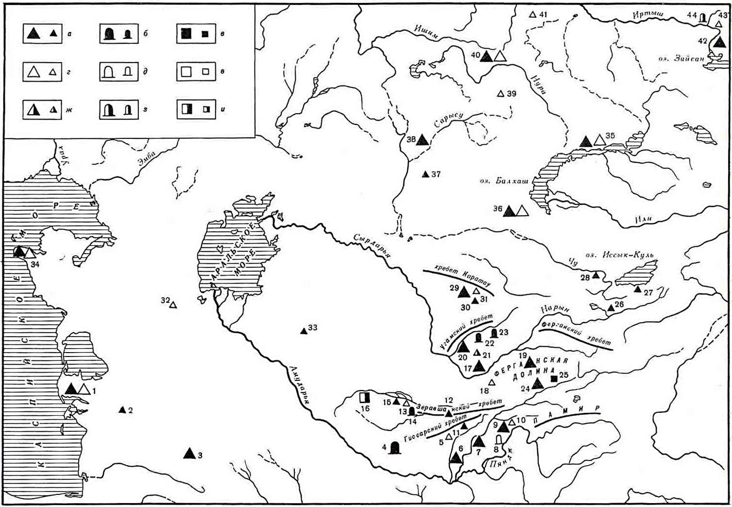
Map of Paleolithic sites in Central Asia and Kazakhstan - Карта палеолитических памятников Средней Азии и Казахстана
Photo: Abramov et al. (1984)
a - Early Paleolithic open air sites - ранне палеолитические стоянки открытого типа
б - Early Paleolithic caves or grottoes - раннепалеолитические пещеры или гроты
в - Early Paleolithic quarries and work sites - ранне палеолитические шахты и мастерские г - Late Paleolithic open air sites - позднее паолеотнческие стоянки открытого типа
д - Late Paleolithic caves - позднее палеолитические пещеры или гроты
с – Late Paleolithic quarries and work sites - позднее палеолитические шахты и мастерские
ж - Multilayer, multi dates open air sites - многослойные разновременные стоянки открытого типа
з - Multilayer, multi dates caves - многослойные разновременные пещеры или гроты
и - Multilayer, multi dates quarries and work sites - многослойные разновременные шахты и мастерские
Large signs indicate groups of sites, small signs denote individual sites - Крупные знаки обозначают группы памятников; мелкие знаки обозначают единичные памятники.
1 - Yangadzha I,II, Kaskyr-Bulak - Янгаджа I, II, Каскыр-Булак 2 - Begarslaydag - Бегарслаyдаг 3 - Tomchi-Su, Otalygzov - Томчи-Су, Оталыгзов 4 - Teshik Tash, Amir-Temir - Тешик-Таш, Амир-Темир 5 - Hudzhi - Худжи 6 – Kuhi-Piez, Kara-Bura - Кухи-Пиез, Кара-Бура 7 - Karatau Tadzhikskij - Каратау Таджикский, 8 - Ogzi-Kichik - Огзи-Кичик 9 - Lakhuti - Лахути 10 - Shugnou - Шугноу 11 - Semiganch - Семиганч 12 - Jar Kutan - Джар-Кутан 13 - Samarkandskaya - Самаркандская 14 - Aman-Kutan - Аман-Кутан 15 - Kuturbulak - Кутурбулак 16 - Uchtut - Учтут: 17 – Kairak-Kum - Кайрак-Кумы 18 - Hodge-Gore - Ходжа-Гор 19 - Ferghana sites - Ферганские стоянки 20 - Bozsu - Бозсу: 21 - Kulbulak - Кульбулак 22 - Khojakent - Ходжакент 23 - Obirakhmat - Обирахмат 24. - Ohna - Охна 25 - Kapchiga - Капчигай 26 - On-Archa - Он-Арча 27 - Tossor - Тоссор: 28 - Georgievskij Bugor (George's Hillock) - Георгиевский Бугор 29 - Borykazgan, Tanirkazgan - Борыказган, Танирказган: 30 - Kara-Su - Кара-Су 31 - Turlansky pereval (Pass) - Турланский перевал 32 - Esen-2 - Есен-2 33 - Kyzyl-Nura - Кызыл-Нура 34-Mangyshlak - Мангышлак 35 - Turanga reka (river) - река Туранга 36 - Gory (Mount) Khantau - Горы Хантау 37 - Jaman-Aibat - Жаман-Айбат 38 - Obalysan Muzbel - Обалысан Музбель 39 - Karabas 3 - Карабас 3 40 - Batpak - Батпак 41 - Angresor 2 - Ангресор 2 42 - Aul Kanai, Svinchatka - Аул Канай, Свинчатка 43 - Novo-Nikolsky - Ново-Никольское 44 - Peshhera (the cave) - Пещера
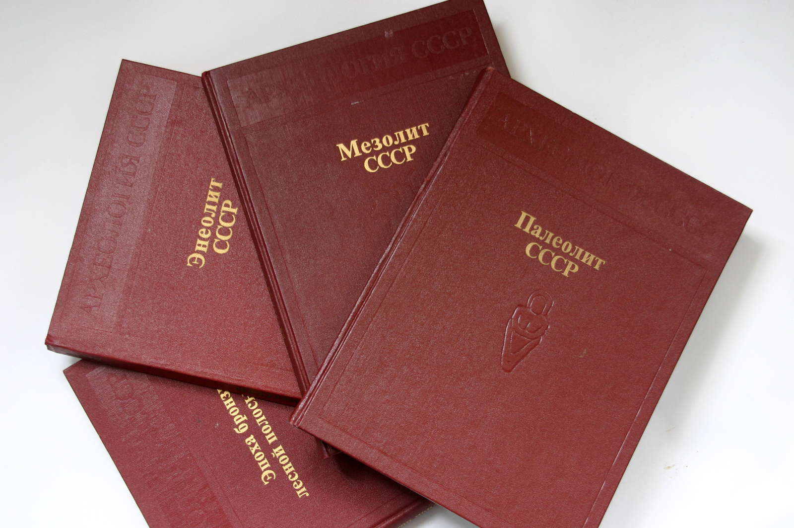
Photo: Abramov et al. (1984)
References
- Abramov A., Anikovich M., Bader N., Boriskovsky P., Lubin V., Praslin N., Rogachev A., А. АБРАМОВА, М. В. АНИКОВИЧ, Н. О. БАДЕР, П. И. БОРИСКОВСКИЙ, В. П. ЛЮБИН, Н. Д. ПРАСЛОВ, А. Н. РОГАЧЕВ, 1984: Archaeology of the USSR. 1984, Nauka, Moscow, 1984
- Abramova Z., 1995: L'Art paléolithique d'Europe orientale et de Sibérie., Grenoble: Jérôme Millon.
- Morgan de J., 1909: Extrait de la Revue de l'Ecole d'Anthropologie de Paris, (juin 1909), p. 189-203. Description: 1 vol. (15 p.) ; in-8.