Back to Don's Maps
 Mousterian (Neanderthal) Sites
La Cotte de St Brelade, Jersey
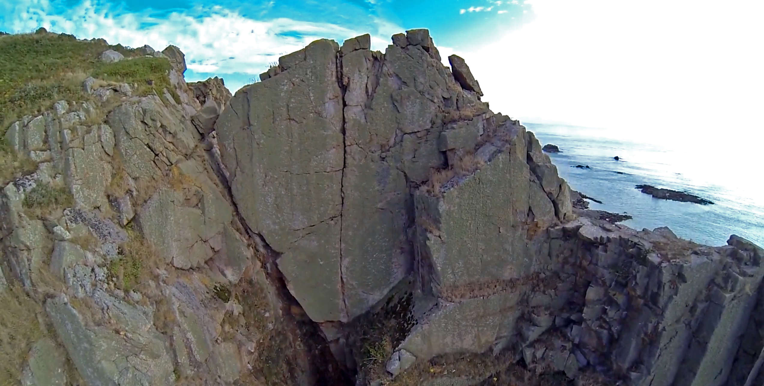
A reconstructed view looking northwards towards La Cotte de St Brelade and the high land that was to become Jersey
Photo: Finch (2008)
La Cotte de St Brelade is a Neandertal site in St Brelade, Jersey. Neanderthals lived there from around 238 000 years ago until between 100 000 and 40 000 years ago - making it the earliest known the occupation of the Channel Islands by a hominin species, and also possibly one of the last Neanderthal sites in northwestern Europe. At that time, with sea levels below those at present, Jersey was part of Normandy, a peninsula jutting out from the coast. After the last Ice Age the sea rose again, separating Jersey from the mainland.
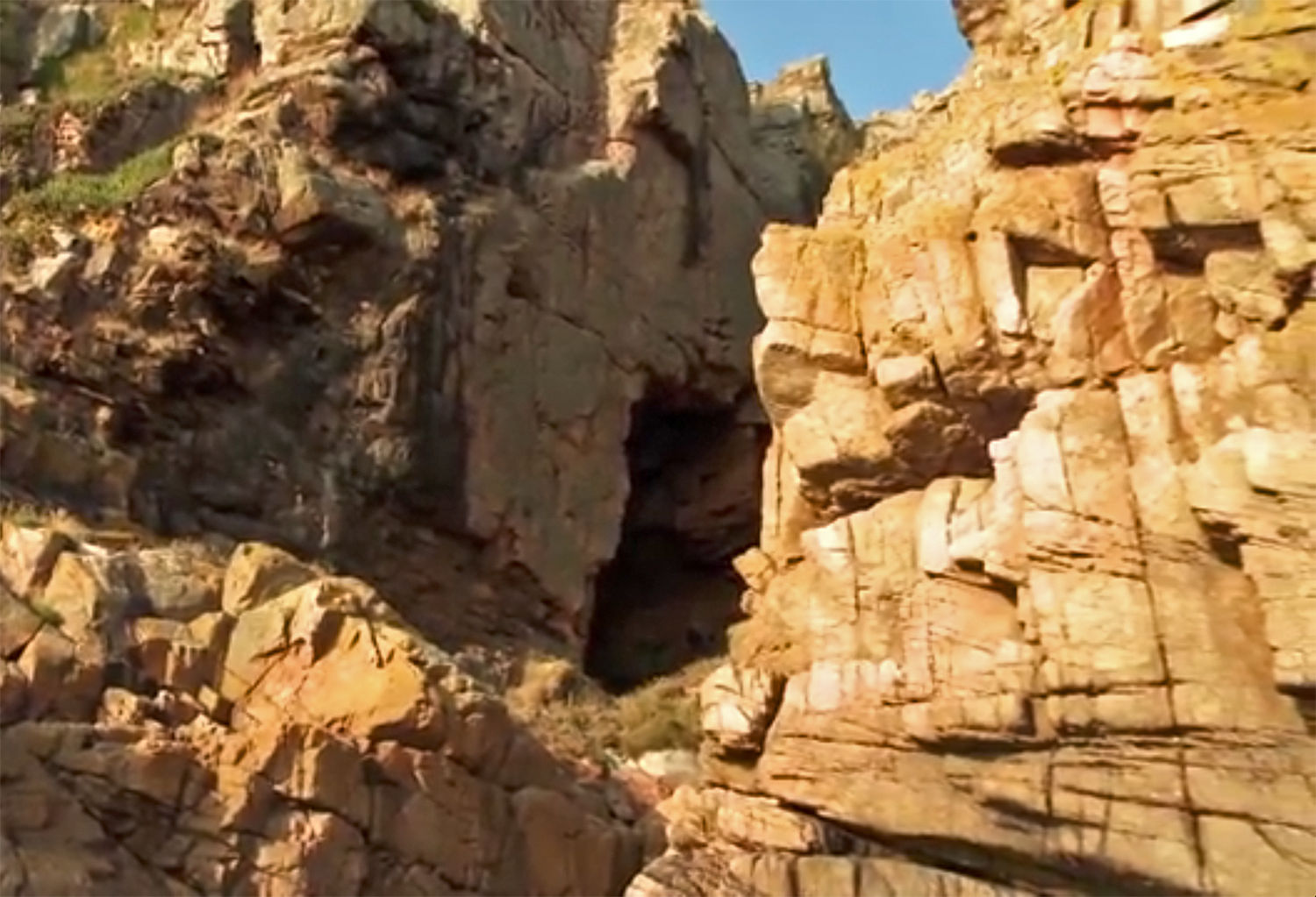
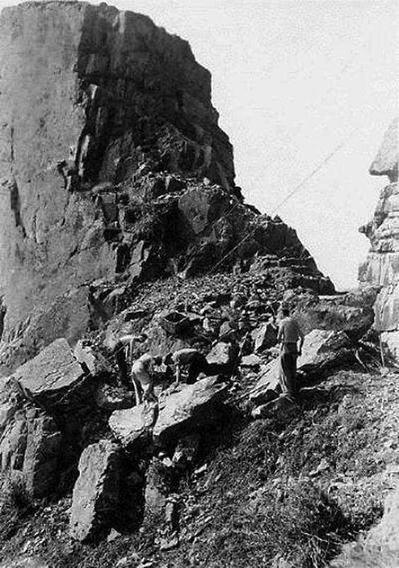
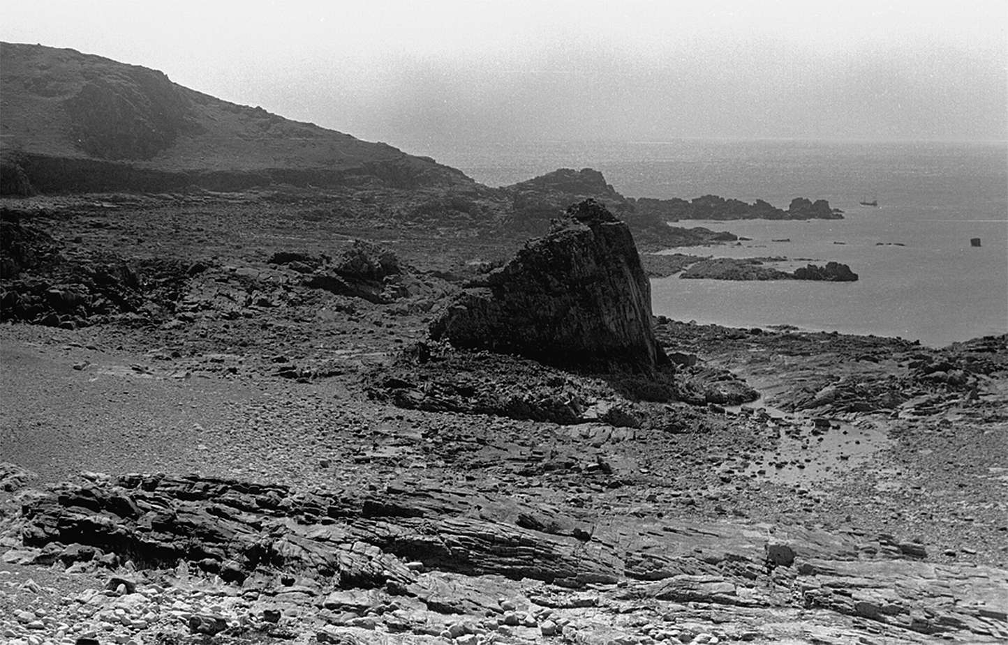
This is a wonderful photo of the entire site.
Here we can see the entrance to the arch on the left, the deposits in the centre, and a stack (the South Pinnacle) gaon the right.
Photo: http://catrionacooper.wordpress.com/2013/07/19/palaeolithic-archaeology-ice-age-island-and-echoes/
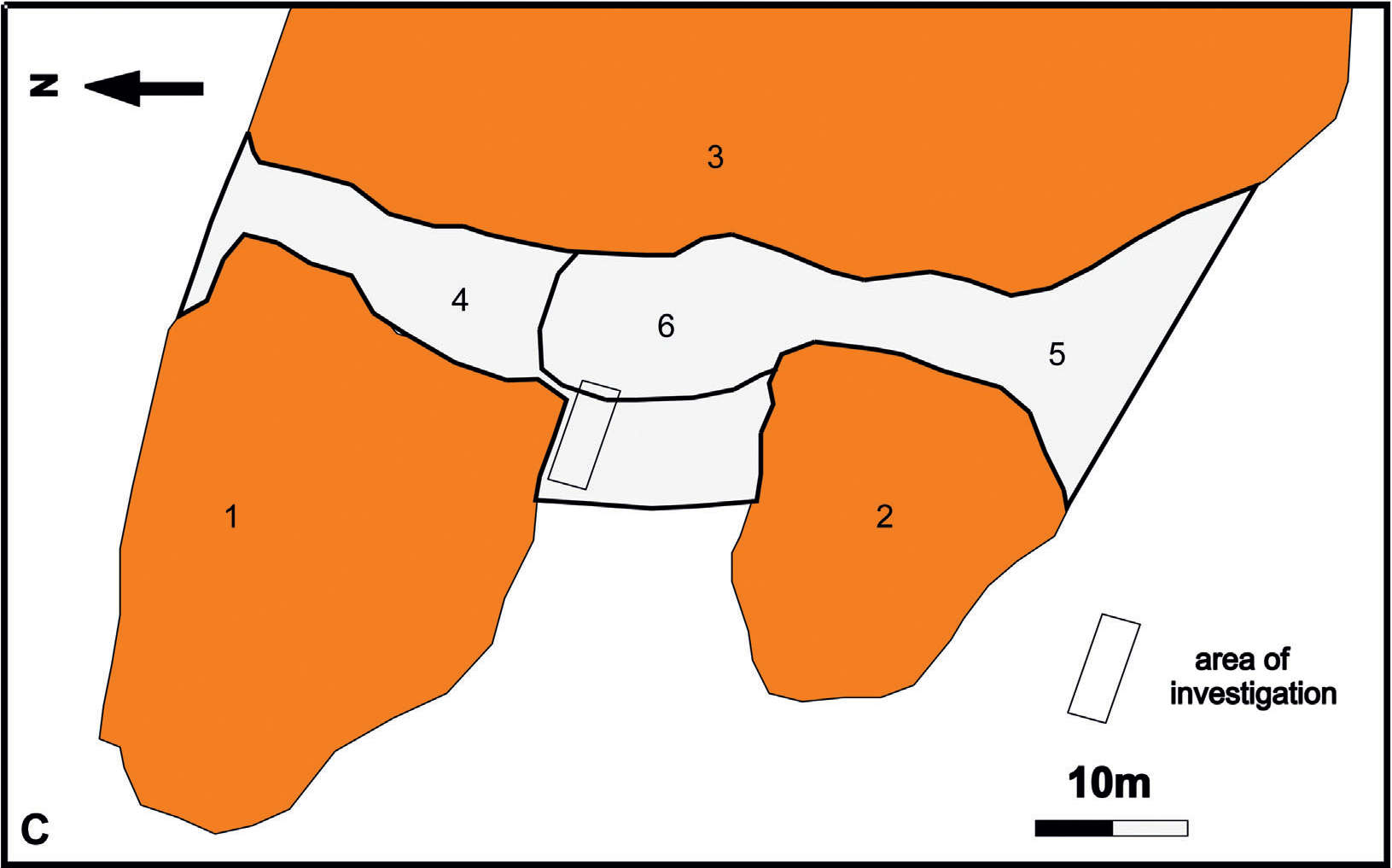
Site plan of La Cotte, based on Callow and Cornford(1986)
1 North Pinnacle
2 South Pinnacle
3 East Wall
4 North Ravine
5 South Ravine
6 central site in the Western Ravine
Photo: Bates et al. (2013)
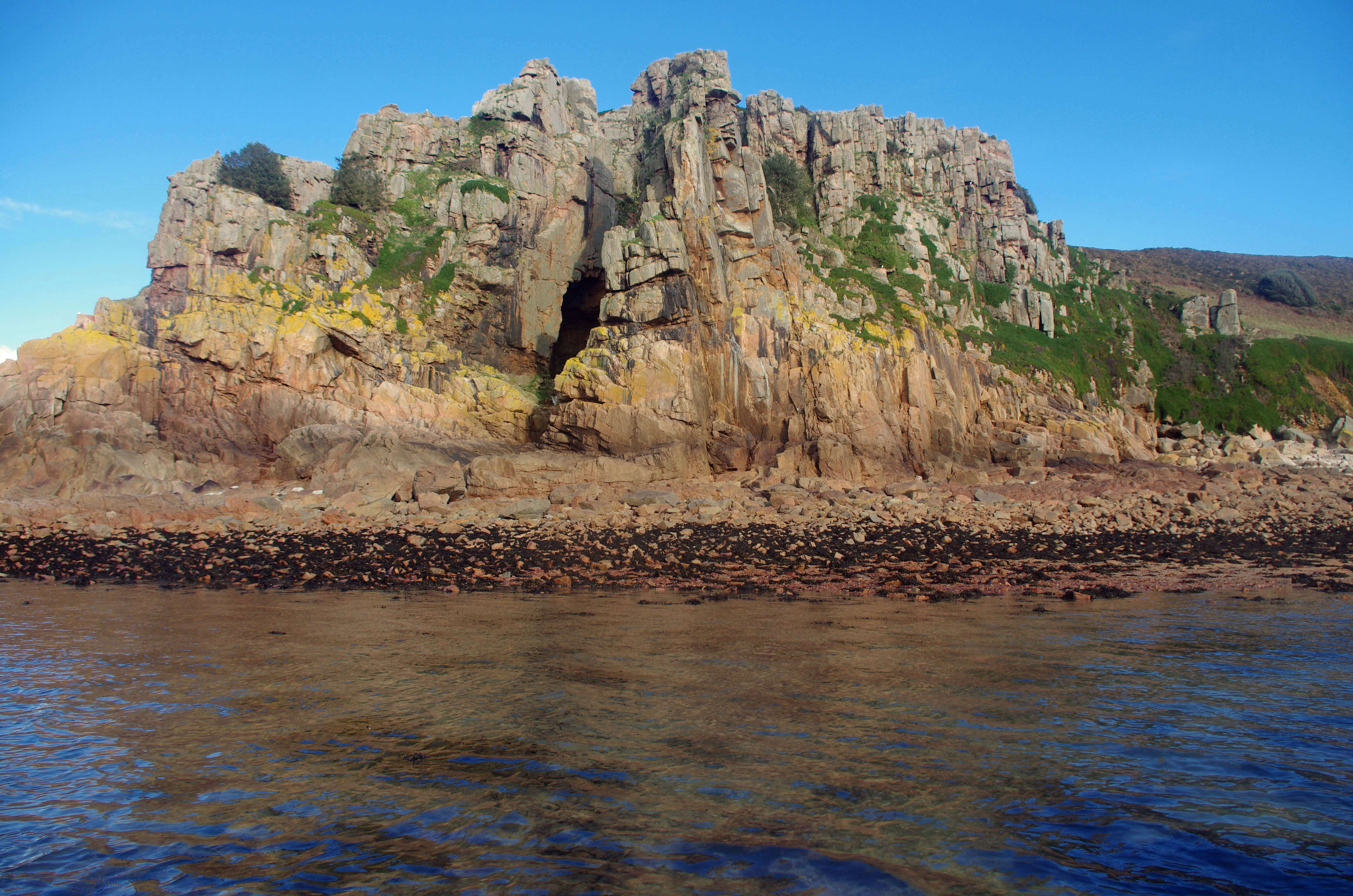
La Cotte de St Brelade as it appears now.
The back of what used to be a cave, on the left, has now collapsed into an arch.
Photo: Natural History Museum video
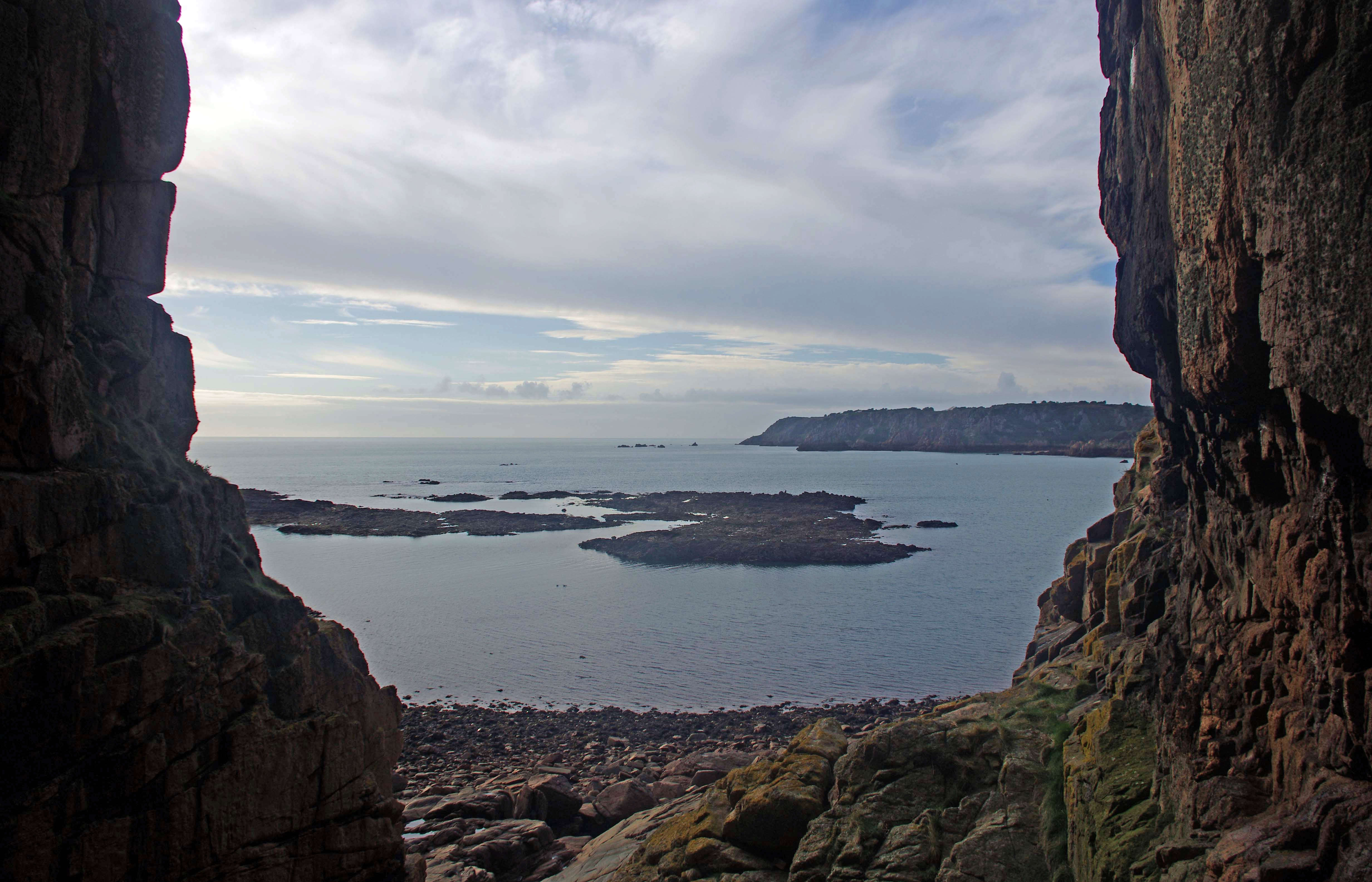
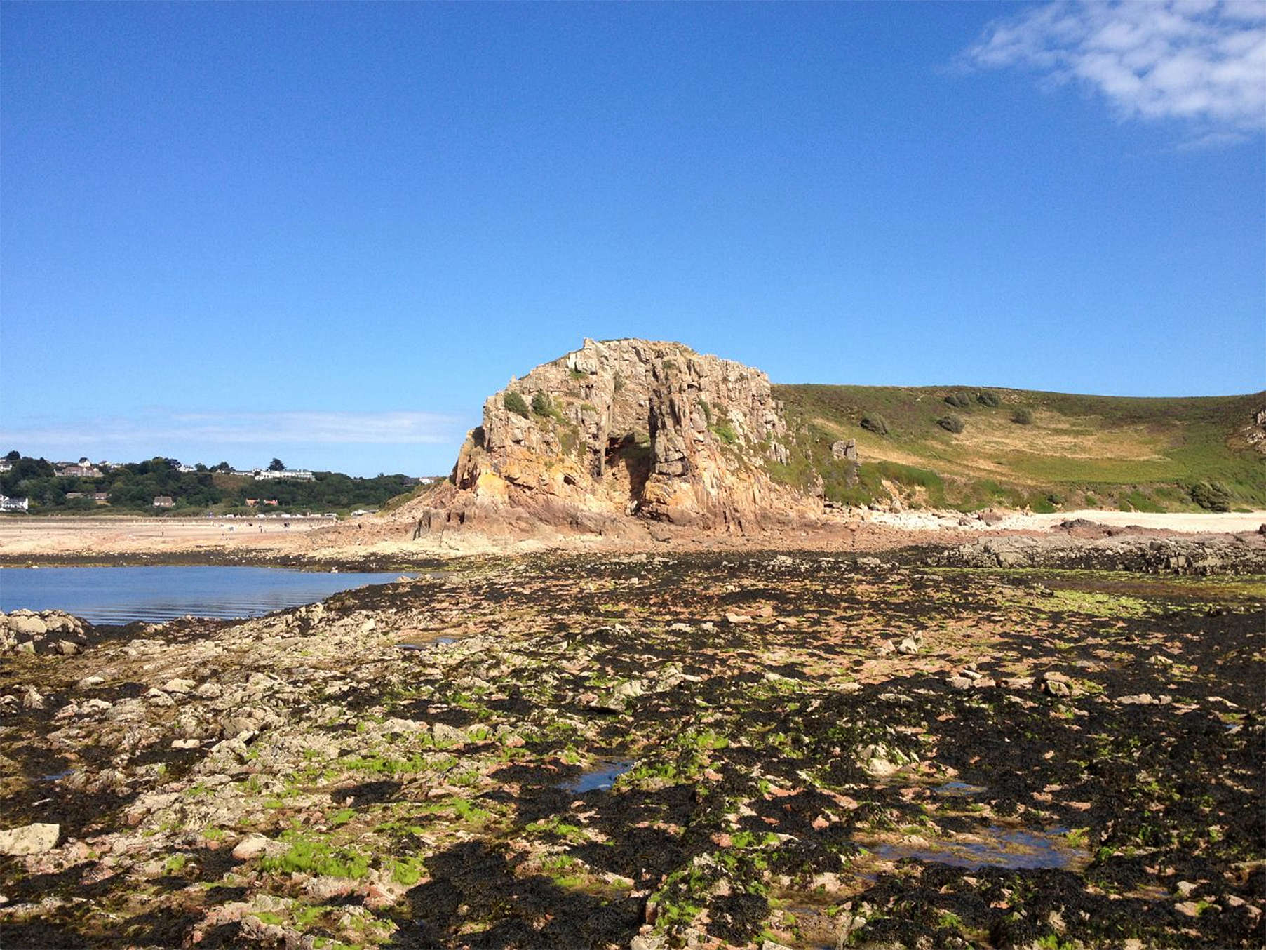
The view towards the sea from La Cotte de St Brelade.
Photo: http://www.jerseyheritage.org/ice-age-key-sites/la-cotte-de-st-brelade-
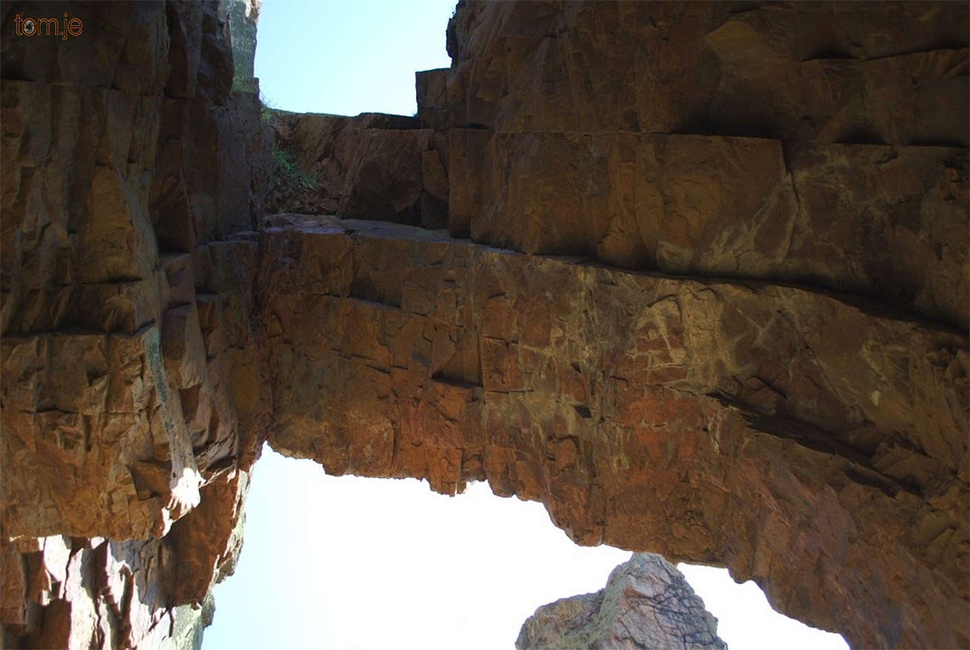
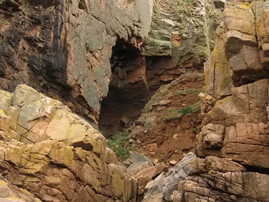
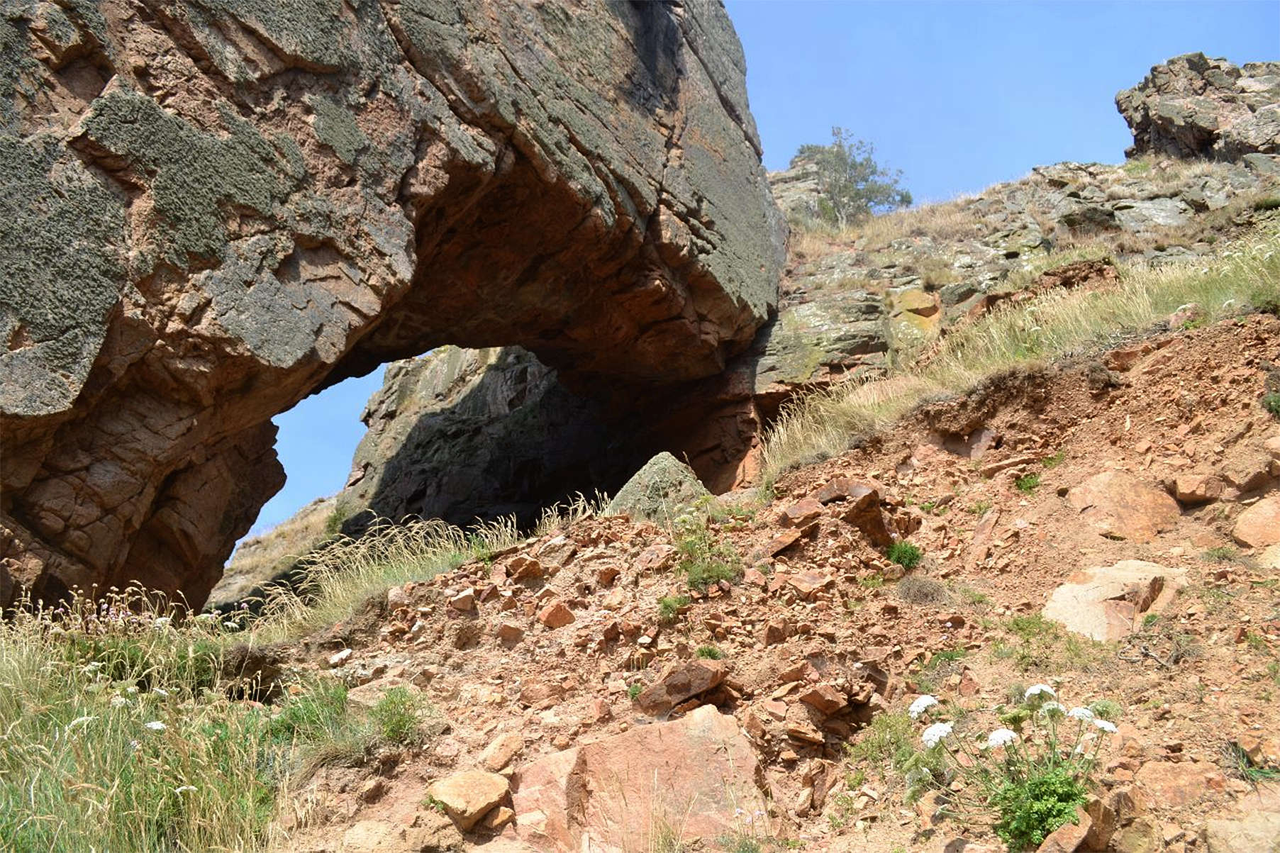
The arch at La Cotte de St Brelade from beneath.
This is all that is left of the roof of the original cave at this point, after a collapse in the early 1900s.
Photo: https://tom.je/index.php?/category/15
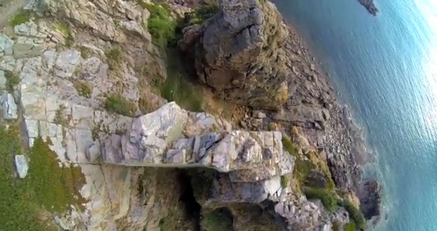
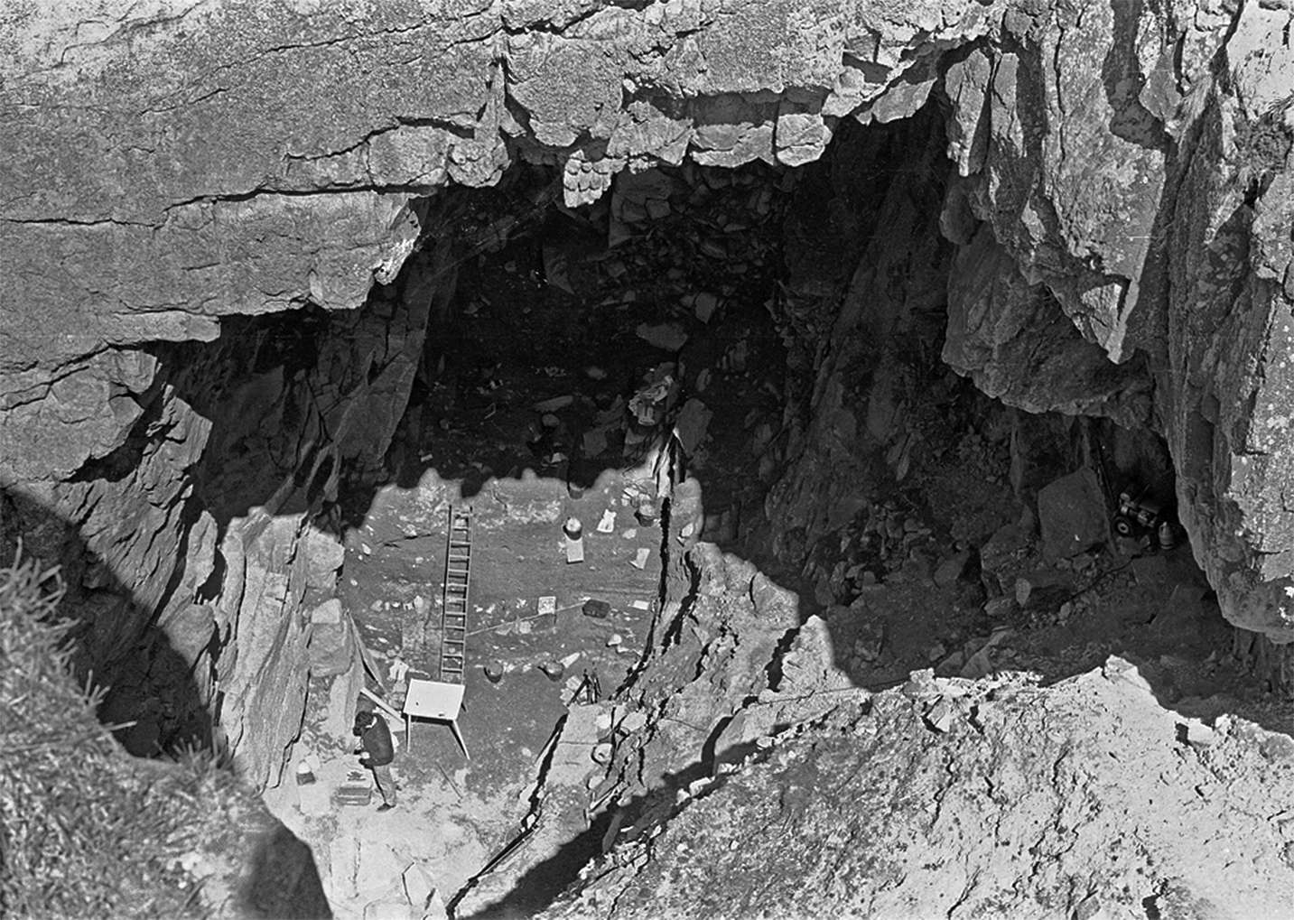
Looking down on top of the arch, with the historical dig site on the 'upper' side in this photograph, on the right as viewed from the ocean.
Photo: S. Baudains Aerial Photography Services, filmed for UCL, https://www.youtube.com/watch?v=jf4H_47xfX8
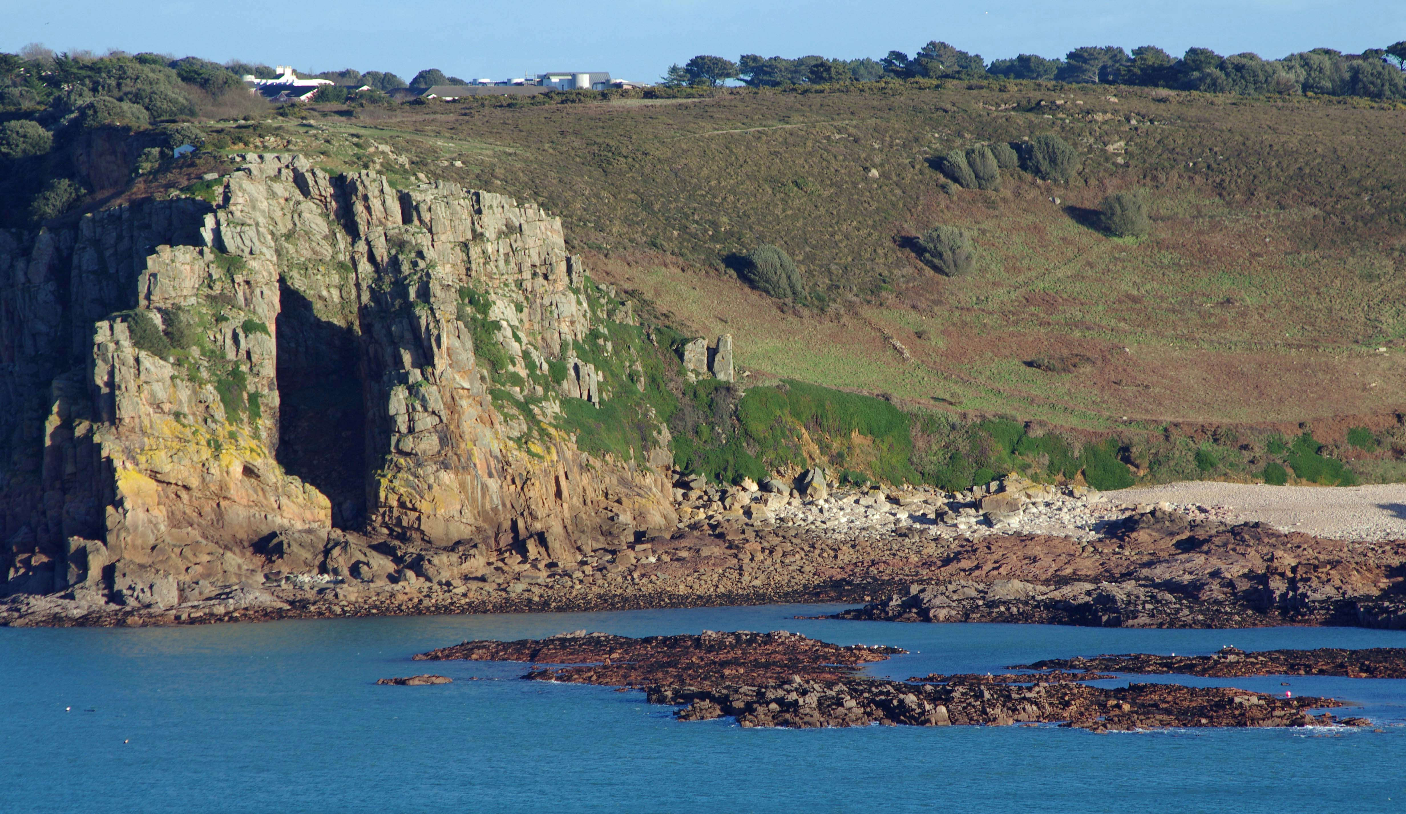
The arch at La Cotte de St Brelade from the 'opposite' side, on the left as seen from the ocean.
Photo: S. Baudains Aerial Photography Services, filmed for UCL, https://www.youtube.com/watch?v=jf4H_47xfX8
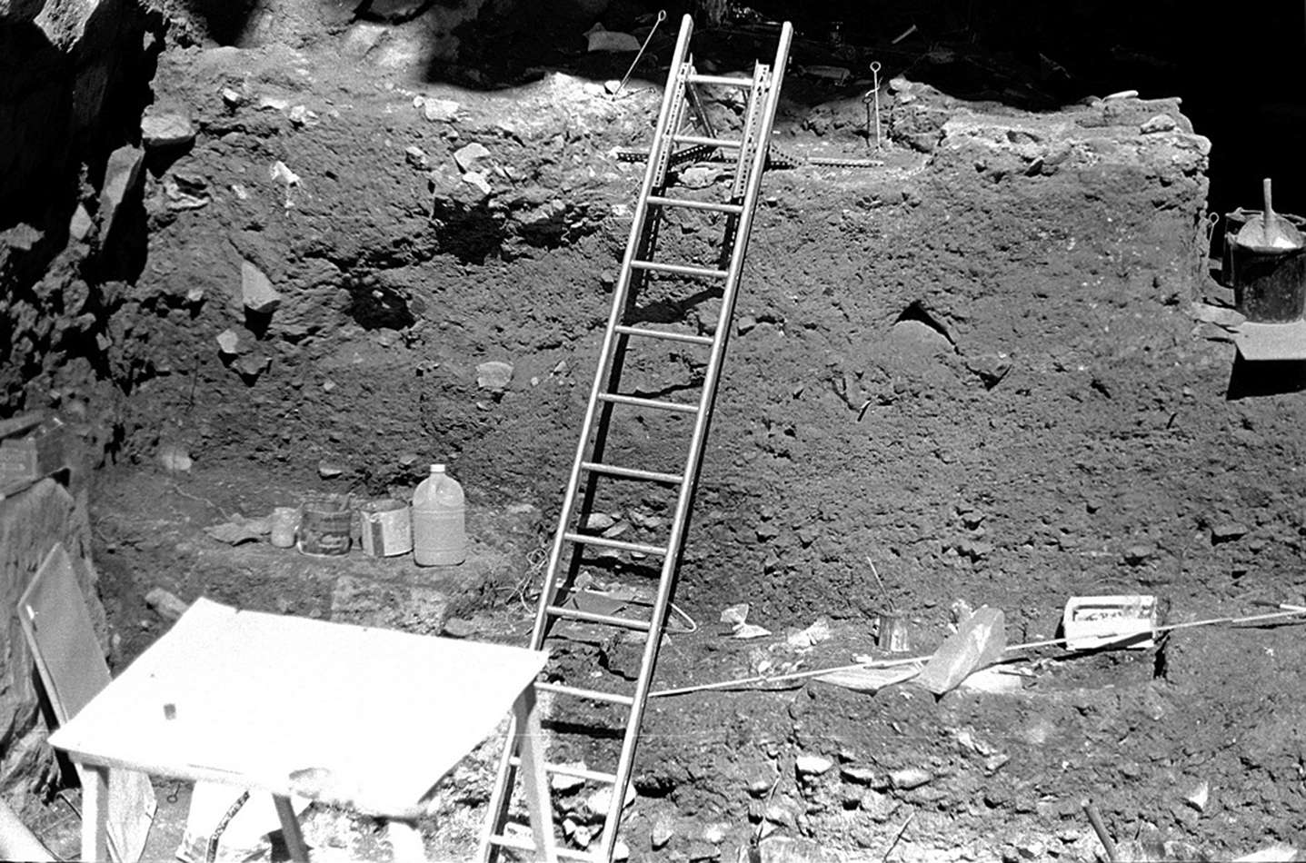
The site at La Cotte de St Brelade in 2009.
The whole site is inherently unstable and dangerous, and great care must be taken to avoid injuries and deaths while working at the site.
Photo: http://www.prehistoricjersey.net/La_Cotte_de_St_Brelade.shtml

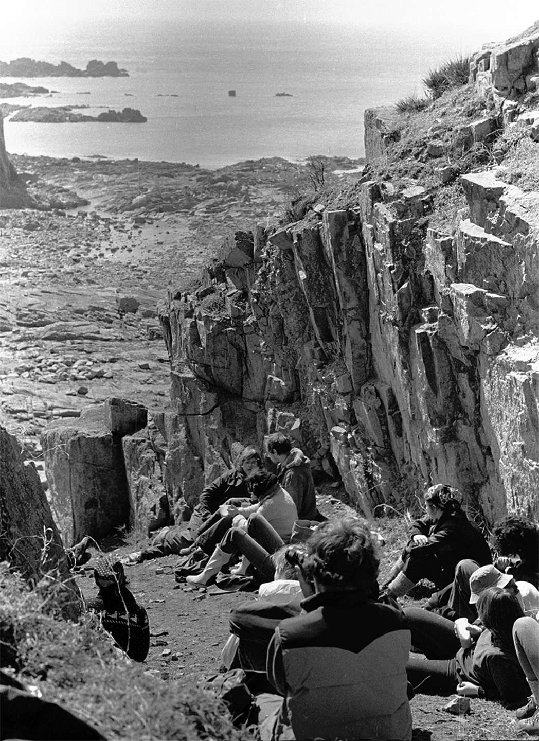
Dr Matt Pope leading a tour of the site, on a hike organised by La Société Jersiaise.
A view of the reinforcement of some of the areas at La Cotte de St Brelade with concrete to avoid collapse of the slopes, and to preserve the sediments for future excavation.
This appears to be in the South Ravine, and the concrete has holes in the lower sections to allow drainage of water seeping from above.
Photo: https://tom.je/index.php?/category/15
Another view of the arch. The site is very steep and difficult to excavate.
Photo: http://www.jerseyheritage.org/ice-age-key-sites/la-cotte-de-st-brelade-
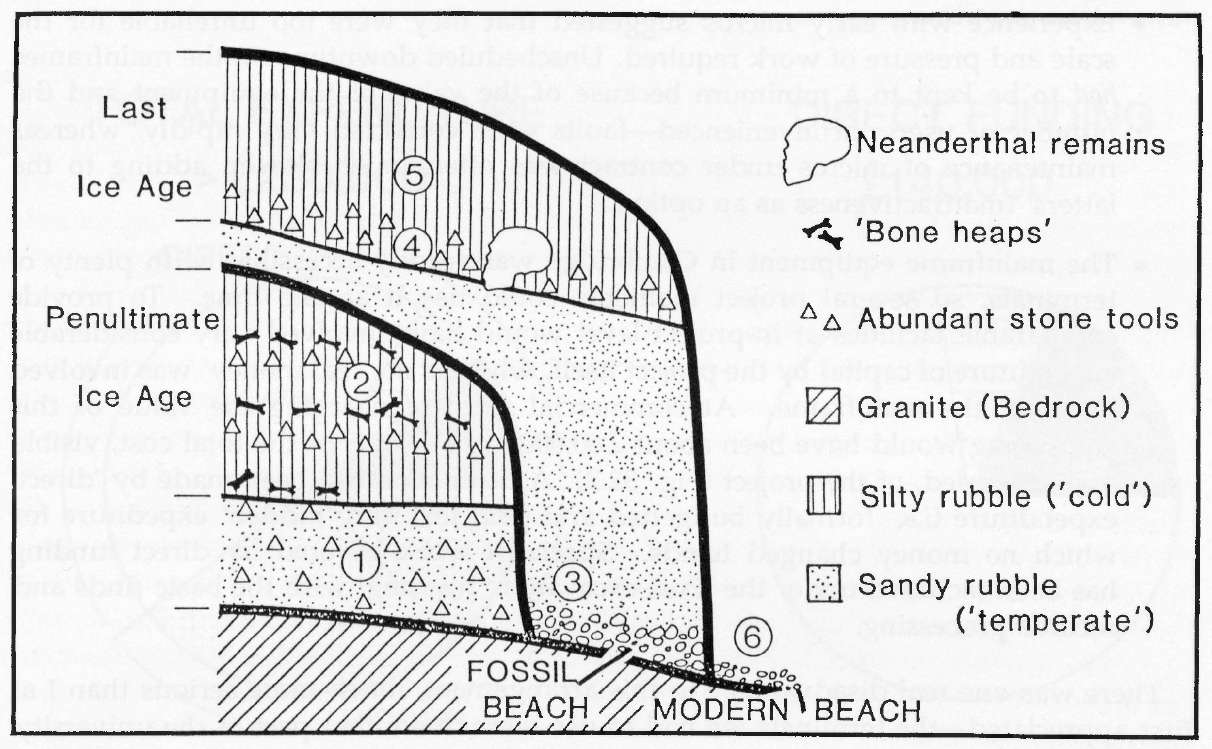
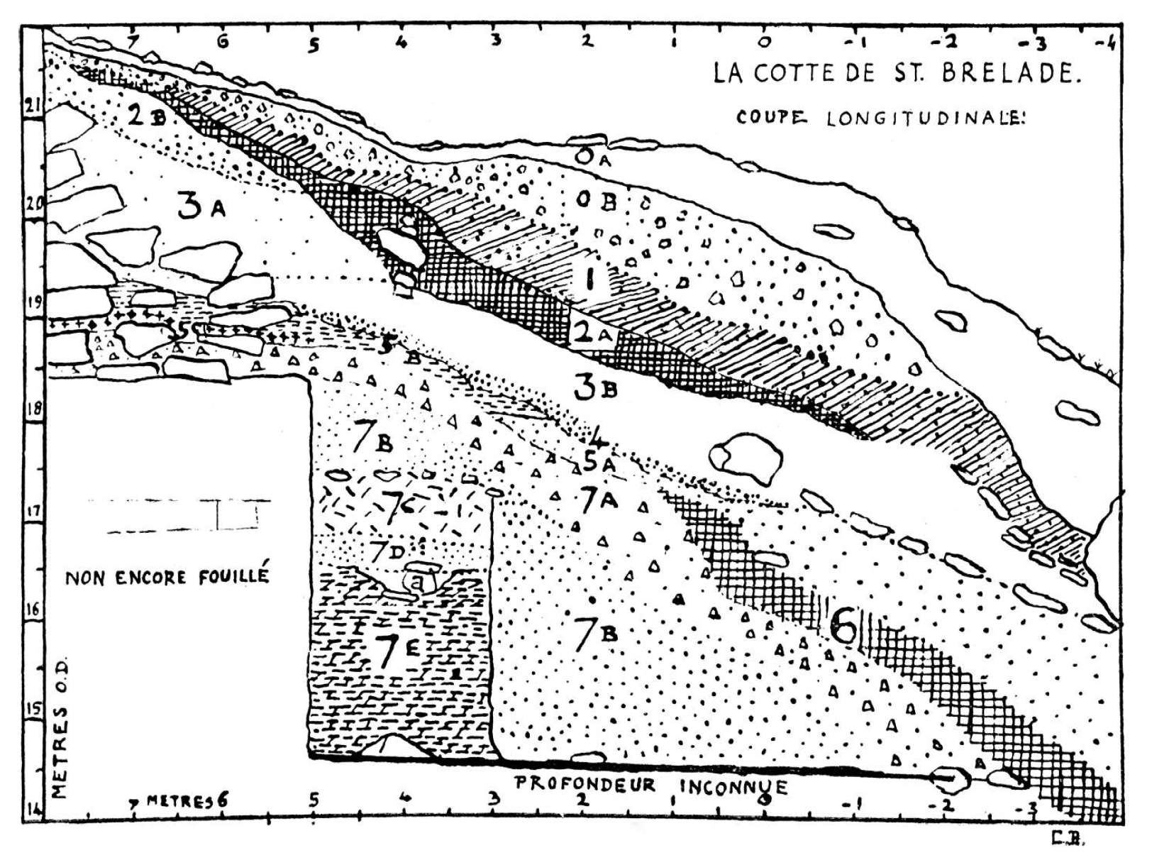
A highly schematic longitudinal section through the ravines at La Cotte de St. Brelade.
1. Interglacial deposits with dense early Middle Palaeolithic occupation, TL age 238 000 ± 35 000
years
2. Cold phase with intermittent occupation and mammoth butchery
3. Last interglacial marine erosion and beach (dated elsewhere to ca 125 000 years)
4. Early last cold phase, with late Middle Palaeolithic occupation and Neanderthal teeth
5. Late last cold phase
6. Recent marine erosion. The Cambridge excavations were chiefly concerned with 1-3
Depth coordinates referred to in this paper are measured from the top of the deposits at
ca 40 m amsl.
(Note that the writer of this paper, who used computer technology to catalogue and position the finds, faced considerable opposition to his use of computer technology from other members of the academic community, firmly rooted, apparently, in the quill and ink methods of previous centuries.
His work later proved invaluable to later researchers once they were able, with considerable difficulty, hard work and a modicum of luck, to translate the data in an old mainframe computer into a format suitable for a desktop computer, which turned out to have considerably more grunt and graphical ability than the best mainframe available at the time of Callow's work - Don )
Photo and text: Callow (1988)
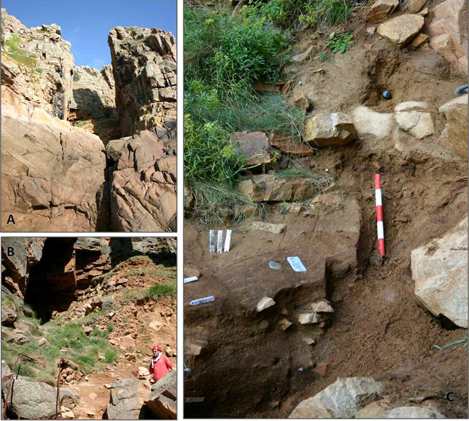
A. View of La Cotte from the west looking into Western Ravine.
B. Intact stratigraphy beneath Burdo’s railway tracks in the Western Ravine.
C. Sampled sediments to the east of railway track in the Western Ravine.
(note that the old railway line, at ground level, was used by excavators of the site in the early 20th Century to dump spoil from the site into the intertidal zone located at the mouth of the fissure system. - Don )
Photo: Bates et al. (2013)
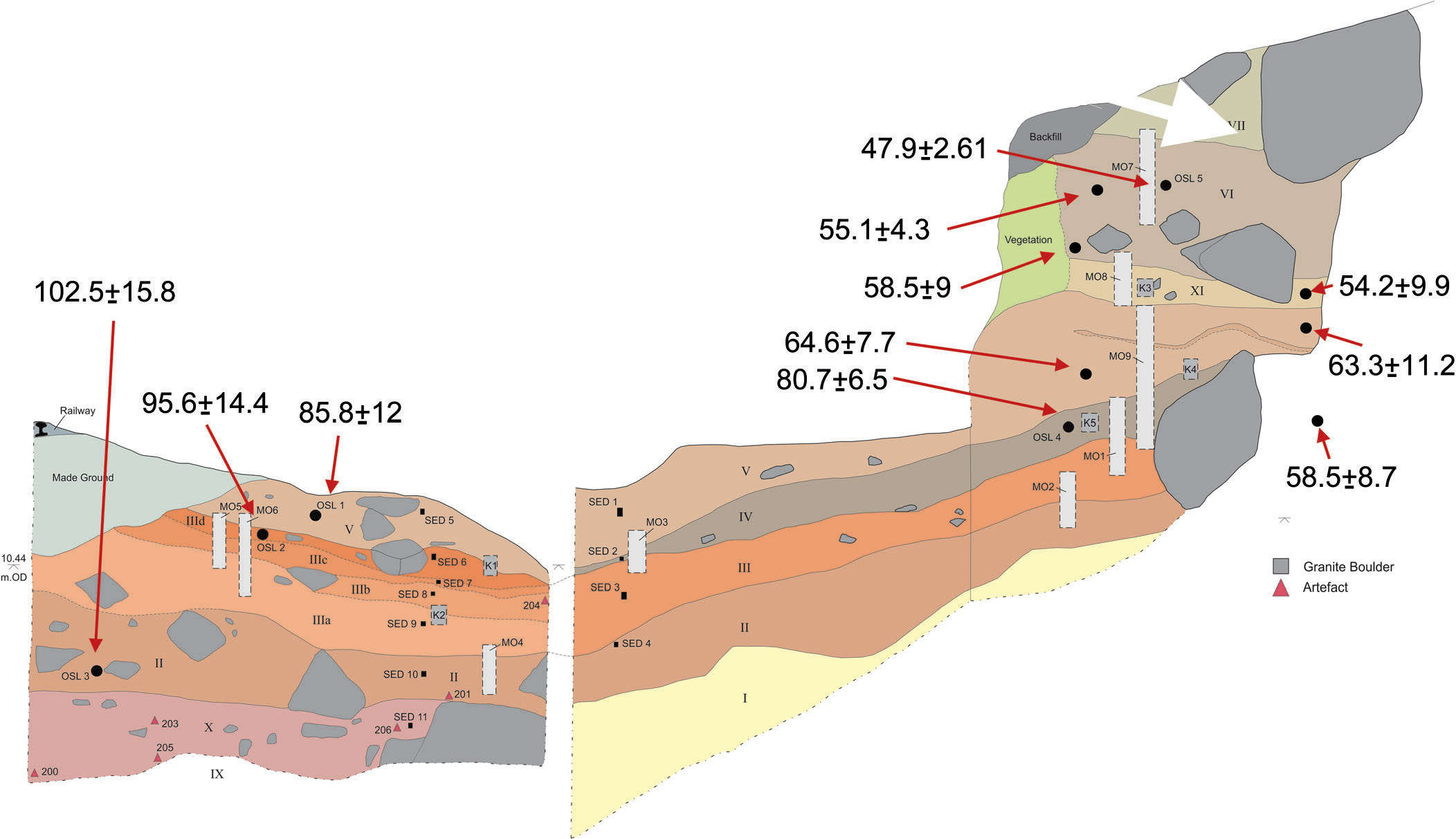
Stratigraphy sampled in the Western Ravine showing the position and ages of OSL (Optically Stimulated Luminescence) dates.
Photo: Bates et al. (2013)
| Units and stratigraphy from railway cutting section in Western Ravine | |
| Unit and Description | Inferred environments of deposition |
|---|---|
| VII. Mid to dark brown clay-silt | Slope wash fans grading downslope into pools and puddles under mild climate. Occasional catastrophic collapses. |
| VI. Grey brown sandy silt | Slope wash fans grading downslope into pools and puddles under mild climate. Occasional catastrophic collapses. |
| XI. Dark brown to yellowish brown gravel | Slope wash fans grading downslope into pools and puddles under mild climate. Occasional catastrophic collapses. |
| V. Mid brown to reddish brown sandy silt to salty sand | Slope wash fans grading downslope into pools and puddles under mild climate. |
| IV. Very dark brown bedded clay–silt and sandy clay–silt. | Slope wash fans grading downslope into pools and puddles under mild climate. |
| III d. Pale yellow–red slightly gravelly sand | Slope wash fans grading downslope into pools and puddles under mild climate. |
| III c. Pale brownish yellow and reddish brown laminated fine to medium sand | |
| III a. Red brown homogenous sandy silt to silty sand | |
| II. Dark brown very coarse to medium sand | Slope wash fans grading downslope into pools and puddles under mild climate. |
| X. Reddish brown gravel | Slope wash fans grading downslope into pools and puddles under mild climate. |
| IX. Mid brown clay–silt with some sand Very poorly sorted, clast-supported gravel | Slope wash fans grading downslope into pools and puddles under mild climate. Freeze–thaw dominating in cold environment with collapse of rock walls/roof |
Working on the deposits at level 3, deposits from the last interglacial, at the junction with the lowest parts of level 4, which is of the early last cold phase, with late Middle Palaeolithic occupation and Neanderthal teeth.
Photo: http://www.jerseyheritage.org/ice-age-key-sites/la-cotte-de-st-brelade-

The rediscovered section at La Cotte de St Brelade in front of the main cave
A team investigating an existing site at La Cotte de St Brelade cave on the southeastern coast of the island stumbled across geological deposits from the last Ice Age, thought to have been lost to excavation a hundred years ago.
'In terms of the volume of sediment, archaeological richness and depth of time, there is nothing else like it known in the British Isles. Given that we thought these deposits had been removed entirely by previous researchers, finding that so much still remains is as exciting as discovering a new site,' said Dr Matt Pope of the Institute of Archaeology at University College London, who helped lead the research.
The site has produced more Neanderthal stone tools than the rest of the British Isles put together and holds the only known late caveman remains in Northwest Europe. When the archaeologists dated the sediments, they found that part of them are from between 100 000 and 47 000 years old, indicating that Neanderthal teeth found there in 1910 were younger than previously thought.
'We were sure from the outset that the deposits held some archaeological potential, but these dates indicate we have uncovered something exceptional,' explained Pope. 'We have a sequence of deposits which span the last 120 000 years still preserved at the site. Crucially, this covers the period in which Neanderthal populations apparently went extinct.'
Photo Credit: UCL Institute of Archaeology
Text: http://www.theregister.co.uk/2013/10/18/new_sediment_dating_jersey/
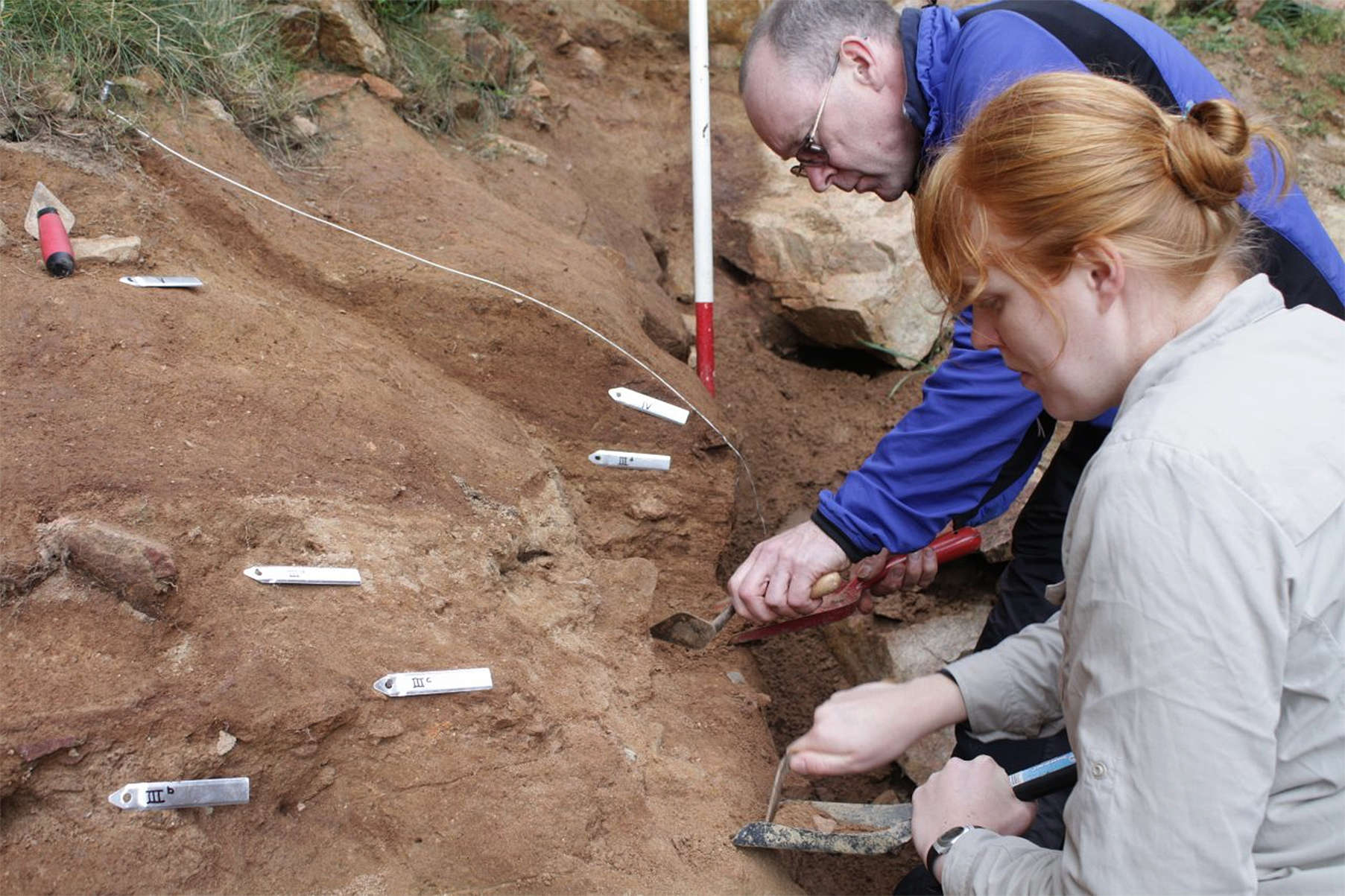
Dr Jean-Luc Schwenninger retrieving dating samples from the rediscovered deposits at La Cotte de St Brelade.
Dr Matt Pope continued:
This was the period during which Neanderthals were kicked off the evolutionary ladder to be replaced by our own species, Homo sapiens.
'Working with our partners to bring these rediscovered sediments under new analysis will allow us to bring the lives of the last Neanderthal groups to live in North West Europe into clearer focus,' Pope said.
'We may be able to use this evidence to better understand when Neanderthal populations disappeared form the region and whether they ever shared the landscape with the species which ultimately replaced them, us.'
Photo Credit: UCL Institute of Archaeology
Text: http://www.theregister.co.uk/2013/10/18/new_sediment_dating_jersey/
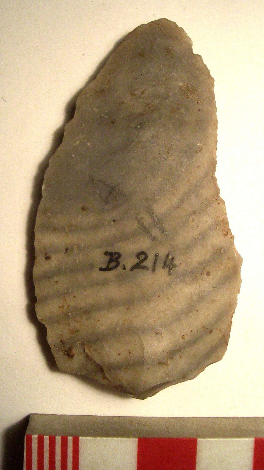
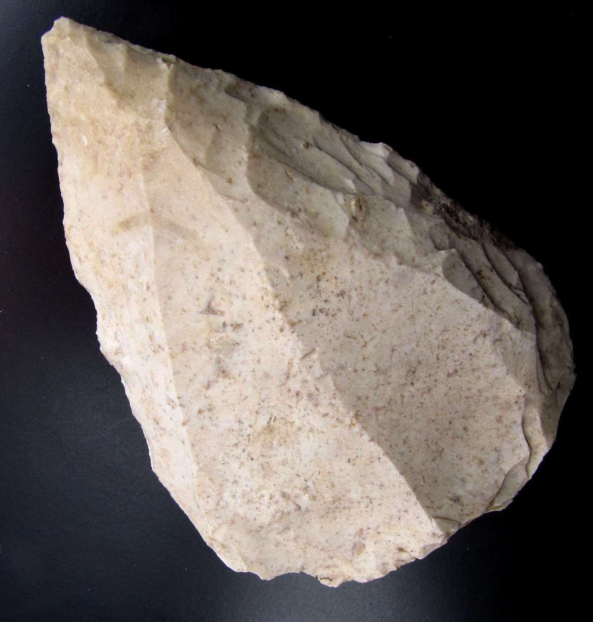
Striped flake from La Cotte de St Brelade. It may be of chert.
Photo: http://www.therocksremain.org/2013/05/studying-stone-tool-assemblages-in.html
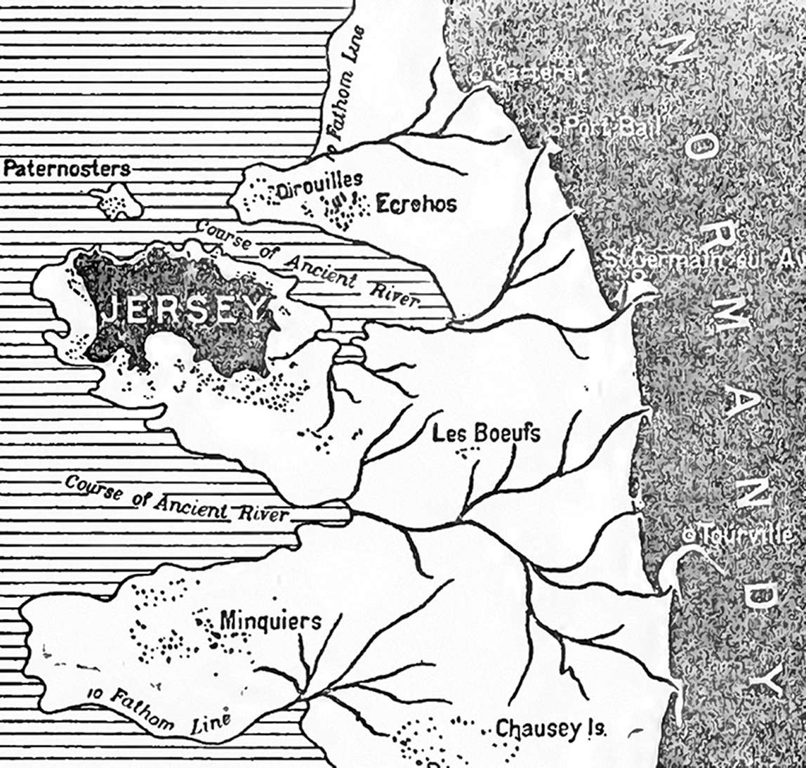
Position of Jersey with the sea 60 feet (18 metres) lower than at present.
(Contour of 10 fathom soundings)
Photo and text: Sinel (1914)
(note that the sea was mostly much lower at the time of the deposits at La Cotte de St Brelade than shown here, and so the shoreline was usually much further out, and also note that this source speaks of 'erosion' rather than sea level change, reflecting the assumptions and understanding of that time. However the map gives a good feel for the relative heights of the landscape around the island of Jersey and La Cotte de St Brelade - Don )
La Cotte de St Brelade at low tide. The site is cut off at high tide, and digs have to be timetabled to take account of the tides.
Photo: http://www.jerseyheritage.org/ice-age-key-sites/la-cotte-de-st-brelade-
La Cotte de St Brelade as it appears in its setting, with the plateau of Portelet Common behind.
Photo: http://jouault.wordpress.com/tag/jersey/
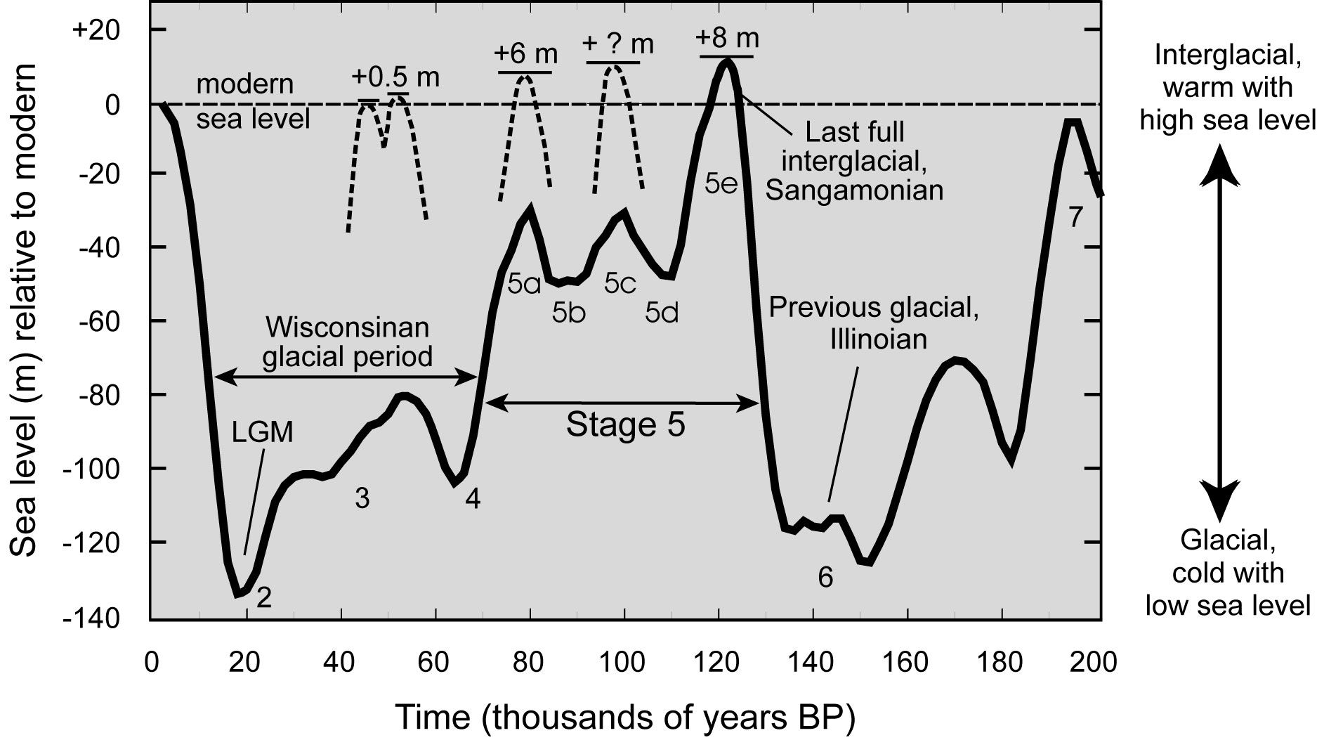
Sea level changes over the last 200 000 years.
Photo: Martinson et al. (1987)

Sea level curve for the last 160 000 years based on Shackleton (2000)
Photo and text: Bates (2011)
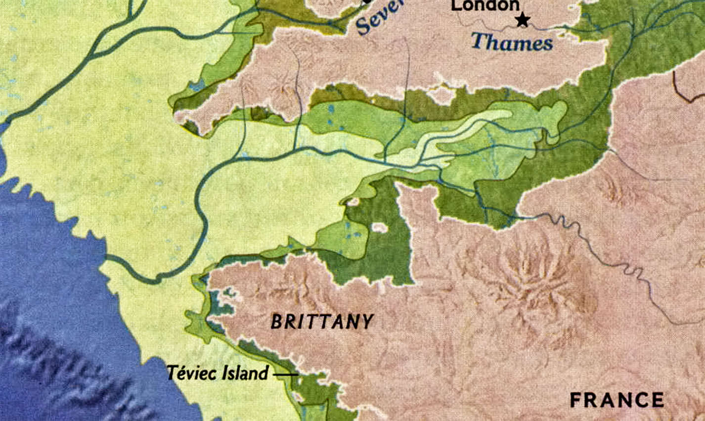
Map of the shoreline in the neighbourhood of the Channel Islands, ca 18 000 BP, when the sea was ~130 metres lower than at present.
Photo: Adapted from National Geographic Vol. 222 No 6 December 2012

The life of Neandertal hunters was difficult. Many bear evidence of healed bone fractures typical of modern rodeo rough riders.
Here is a family group with the father lying on the floor, pale from loss of blood, mortally injured, while the remaining members of his family - his mate, mother and children - contemplate their future without him.
Note that although not credited, this is the work of Elizabeth Daynès, a master of such sculpture.
It is part of a display at the Krapina Neanderthal Museum in northern Croatia where she made a reconstruction of an entire seventeen member Neandertal family.
Photograph: Nikola Solic/Reuters/Corbis
Source: An exhibit at the Neanderthal Museum in Krapina, Croatia.
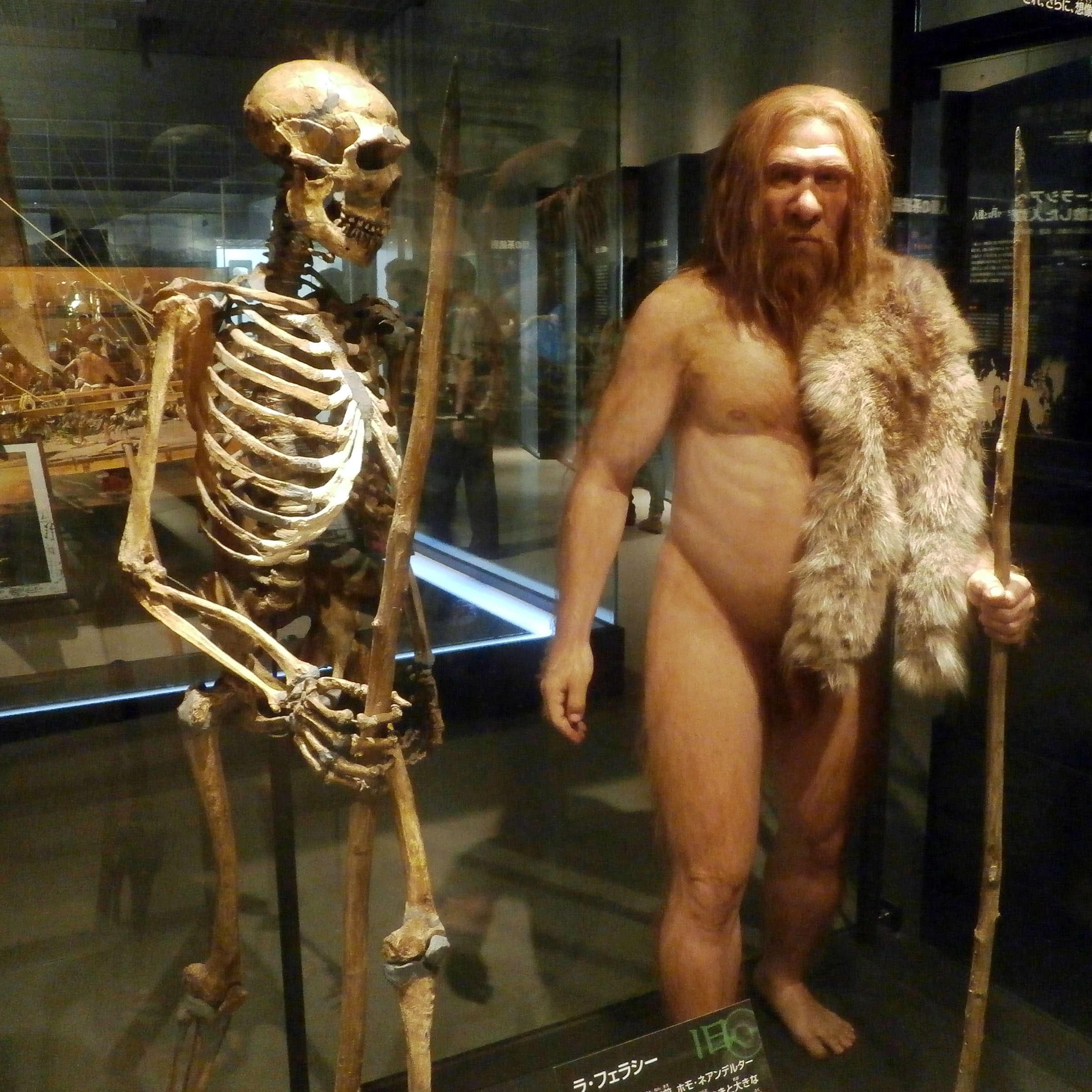
Neanderthals were very strong and stockily built. This reconstruction of the La Ferrassie 1 skeleton shows an older man still capable of prodigious feats of strength.
Photo: Photaro
Permission: Creative Commons Attribution-Share Alike 3.0 Unported license.
Source: National Museum of Nature and Science, Tokyo
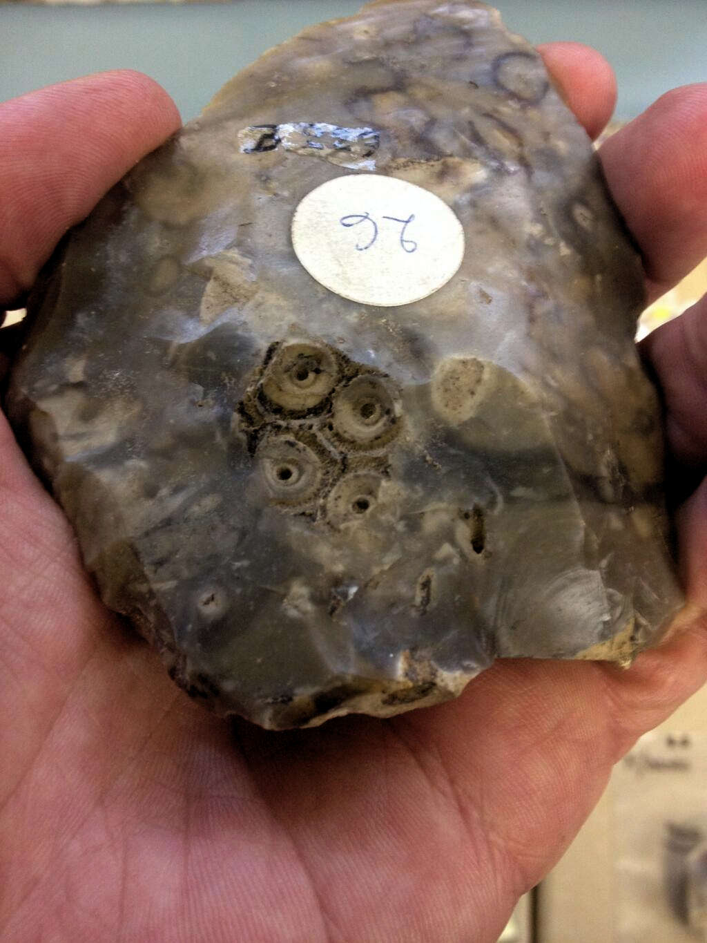
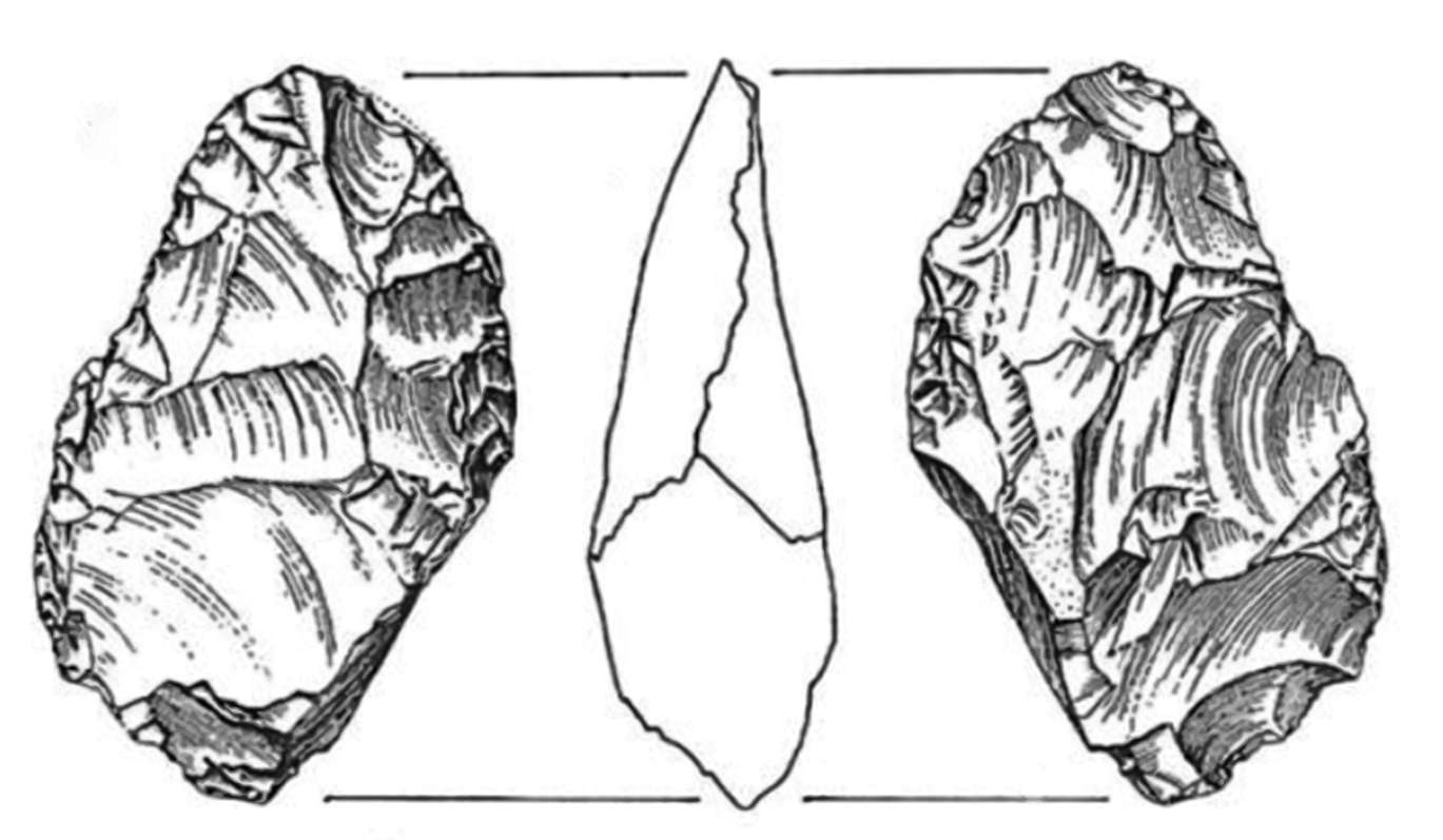
Echinoid fossil (Alloma?) in a Levallois flake from La Cotte de St Brelade, Jersey.
Photo and text: © Dr Matt Pope
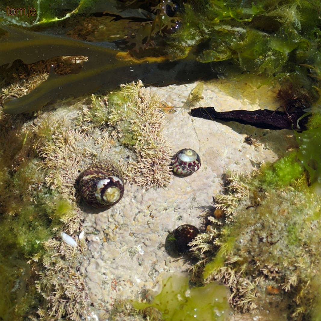
Neanderthals apparently did not make use of the abundant marine life which was (periodically) near St Brelade.
These Banded Trochus Snails, Turban Top Shells, were in a rock pool close by the site.
Photo: https://tom.je/index.php?/category/15

A quote from Dr Matthew (Matt) Pope, on the importance and future prospects of the site. Articulate, lucid, and with great presence and charisma, he is one of the finest lecturers it has been my pleasure to see and listen to. He is able to encapsulate difficult concepts in a way that the layman can understand, but without losing academic rigour. These are most unusual attributes in archaeology, and he has a very bright future.
The 2010 season was targeted, but we were able to report three significant facts, considerably changing our appreciation of the site. Firstly, large parts remain untouched, perhaps as much as 60% of the original Pleistocene sediments still being in situ. Secondly, much of this rich site lies unprotected and at the mercy of the powerful Atlantic-driven elements, so long term management now needs to be considered. And thirdly, James's survey is indicating that the current appearance of La Cotte as a series of ravines is a recent state of affairs.
In the earliest phases of human habitation (over 250 000 years ago) La Cotte would have looked very different, possibly comprising an entirely roofed cave system, the entrance to which is still sealed and has never been investigated. We can now see that this entrance, along with deposits thought lost which had contained the neanderthal human remains, are present and intact. La Cotte offers future research an unparalleled, clearly defined resource through which to study directly a long evolutionary arc of human activity.
Photo: http://www.news.com.au/technology/science/archaeologists-find-last-neanderthals-at-le-cotte-de-st-brelade-jersey/story-fnjwl1aw-1226743625496
Photo: Another source is at https://www.youtube.com/watch?v=KEWm9trkaRQ
Text: http://www.archaeologyuk.org/ba/ba117/feat3.shtml
The Problem of the Mammoth Drive
Did Neanderthal hunters drive mammoth herds over cliffs in mass kills? Excavations at La Cotte de St Brelade in the 1960s and 1970s uncovered heaps of mammoth bones, interpreted as evidence of intentional hunting drives. New study of this Middle Palaeolithic coastal site, however, indicates a very different landscape to the featureless coastal plain that was previously envisaged.
Reconsideration of the bone heaps themselves further undermines the 'mass kill' hypothesis, suggesting that these were simply the final accumulations of bone at the site, undisturbed and preserved in situ when the return to a cold climate blanketed them in wind-blown loess.
Text above is the abstract of: Scott et al. (2014)
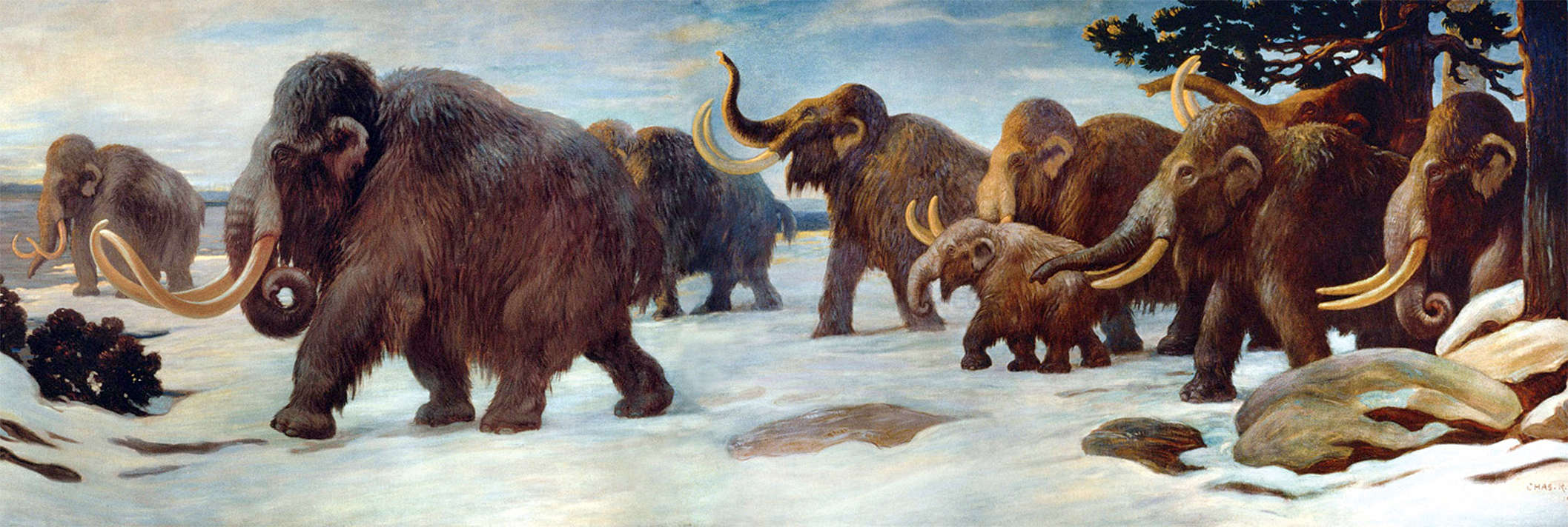
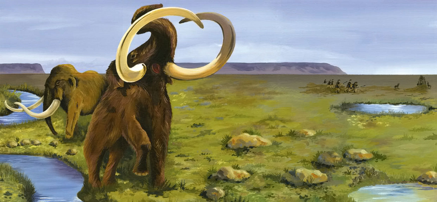
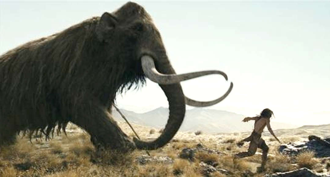
A herd of Mammoths similar to that which was hunted by the Neandertals of La Cotte de St Brelade.
Photo: Charles R. Knight
Permission: Public Domain
Until recently, it was believed that the deep ravines at La Cotte de St Brelade provided a location for game drives by Neanderthal hunters, who drove them over the cliffs above the ravines.
This view was driven by the analysis of two distinctive bone heaps dated to the early MIS 6, a cooler period of the Middle Palaeolithic, ca 190 000 BP. (Scott, 1980, 1986b).
Scott concluded that the composition and arrangement of the bone heaps was most consistent with Neanderthal hunters driving mammoth herds over the headland into the deep granite ravines. The involvement of Neanderthals in premeditated and organised predation challenged assumptions concerning their cognitive capabilities as hunters. La Cotte de St Brelade therefore entered the canon of key Middle Palaeolithic localities which offered in the last decades of the twentieth century a new perspective on Neanderthal populations.
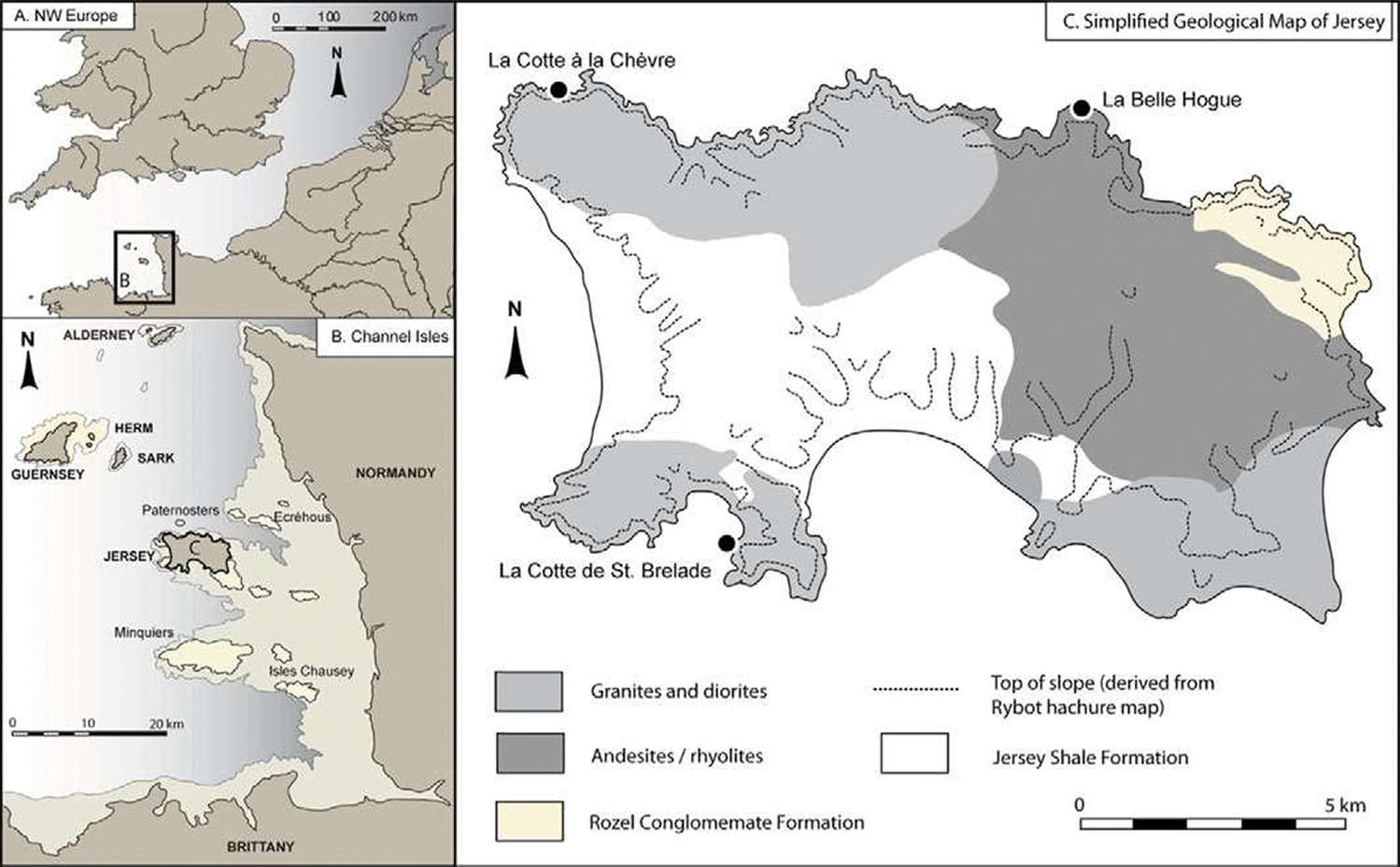
A) Position of the Channel Islands within north-western Europe; B) position of Jersey in relation to the other
Channel Islands and the northern French coast; C) simplified geological map of Jersey, showing the position of the main sites
mentioned in the text. Based upon an image supplied by John Renouf.
Photo and text: Scott et al. (2014)
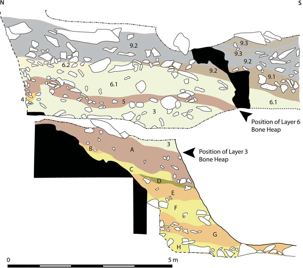
Composite section (west-facing) through the deposits infilling La Cotte de St Brelade, showing the position of the bone heaps (modified from Callow (1986a): 61, fig. 6.6).
(note that the black arrows in the diagram point to the bases of the pale green relevant layers, 3 and 6 - Don )
Photo and text: Scott et al. (2014)
The following quote from Scott (1986b) in Hublin and Richards (2009) sums up the prevailing view until fresh evidence of the layout of the seabed near Cotte de St Brelade came to light:
It should be noted that the respective bone heaps are in layers 3 and 6, are two separate accumulations of bones of woolly mammoths (total Minimum Number of Individuals = 18) and woolly rhinoceros (total Minimum Number of Individuals = 5). Only a small portion of the original site was excavated, approximately 12 m2 in layer 3 and 18 m2 in layer 6. Mammoths and rhinos comprise essentially the entire fauna of these two levels; a few bones of other species occur only at the base of each level.
The site is the base of a deep ravine (about 30 m at the time of deposition of layers 3 and 6) and there are several indications that there were rapid accumulations: some bones were found to rest vertically against other bones, a few bones were found in articulation, several mammoth scapulas were stacked in direct contact with each other without intervening sediment, and there was no evidence of subaerial weathering. The age distribution indicates a predominance of sub-adults and prime age adults. It would have been impossible to kill a group of such dangerous animals without driving them off the cliff. Rhinos are frequently found on the fringes of herds of elephants, so they could have been driven together with the mammoths.
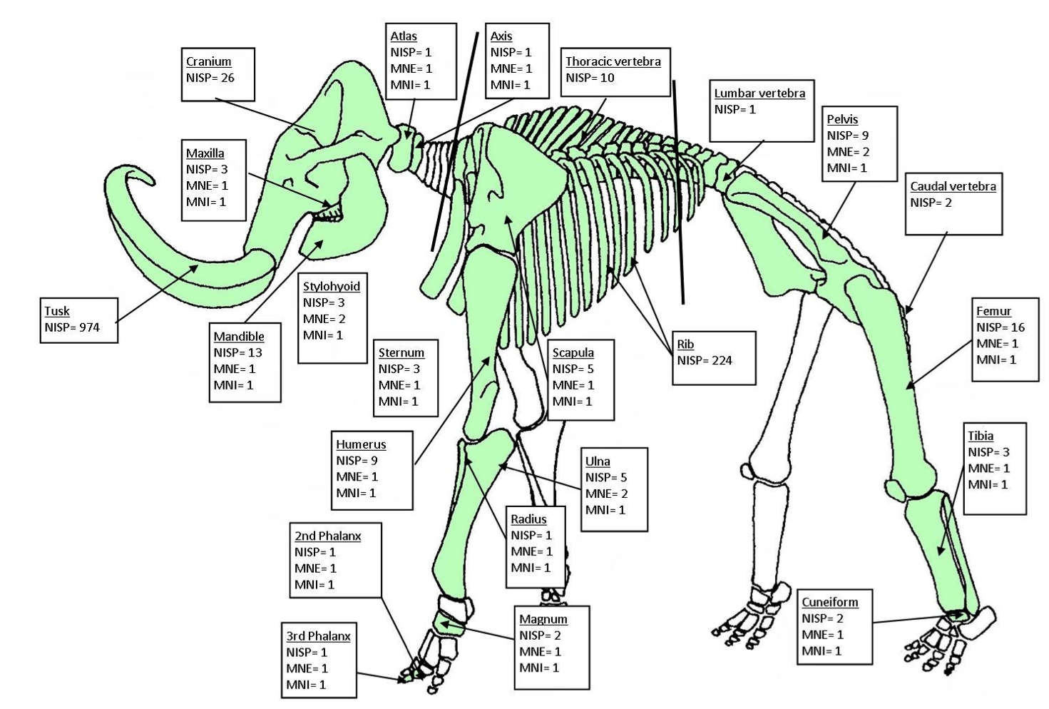
This is a very useful diagram of a mammoth skeleton.
The labels refer to data from a mammoth site at Lynford (UK) near Ickburgh, beside the River Wissey.
Photo: Smith (2010)
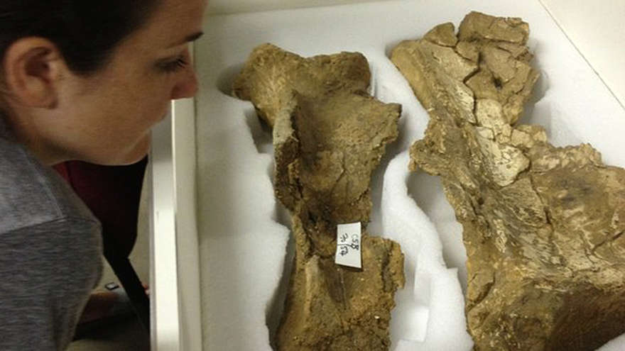
Mammoth shoulder blades, scapulas, found at La Cotte de St Brelade.
Photo: http://www.bbc.com/news/world-europe-jersey-24083233
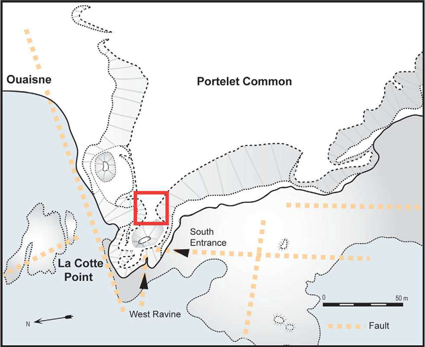
Modern topography of La Cotte Point as projection from Portelet Common. Note the constriction (boxed in red) before the steep climb to reach ground above the fissure system, in line with the fault mapped to the north. This would have formed a significant barrier to the drive of a herd of mammoths to the top of the cliff (map modified from Callow & Cornford (1986): fig. 4.5).
Photo and text: Scott et al. (2014)
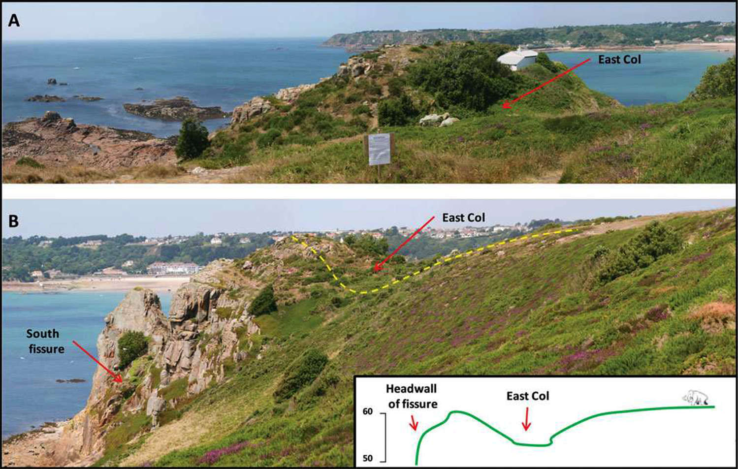
A) View of the approach to the La Cotte fissure from Portelet Common, crossing the steep dip and climb across the East Col.
B) relative heights of dip and climb to reach the La Cotte headland.
(These photographs highlight the difficulty of herding mammoths (and rhino) from the plateau of the Portelet Common into the constriction and dip of the East Col, and then driving the animals up a steep grade to the final drop into the fissure.
The only other possibility is that this microgeography was different at the time of the drive, and that the East Col, the dip, and the climb to the headland are erosional features which were created during the last ice age, after the drive of mammoth ca 190 000 BP towards the fissure and drop, over a relatively much wider and more gradual gentle and even downhill approach, which constantly narrowed, gradually bunching up the herd.
This scenario means that all the hunters had to do was the much easier task of driving the mammoths in the right direction, without needing to risk life and limb in the actual killing of the animals - Don )
Photo and text: Scott et al. (2014)
However, another possibility for the drive is from a direction 180° away, from what is now sea floor.
Scott et al. (2014) have done a survey of the microstructure of the sea bed in the vicinity, and have discovered the following:
La Cotte was located at the margins of a complex granite landscape of bluffs, canyons and valleys. A small valley has been mapped running in a northerly direction directly towards the south-facing entrance of La Cotte, which ends in an abrupt line of rising granite bluffs just below the site.
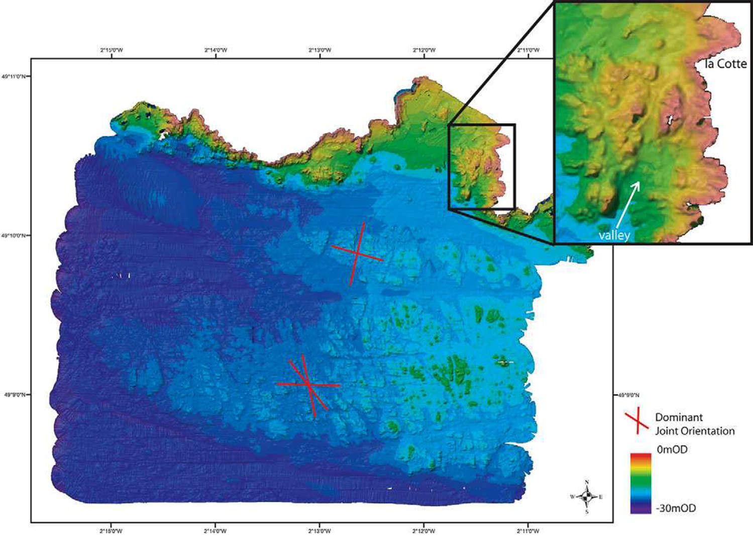
Bathymetric chart of the area surveyed; depths given to 20 cm vertical resolution and at a lateral bin-resolution of 50 cm. Inset shows detail of valley running north up to south entrance to La Cotte fissure system
Photo and text: Scott et al. (2014)
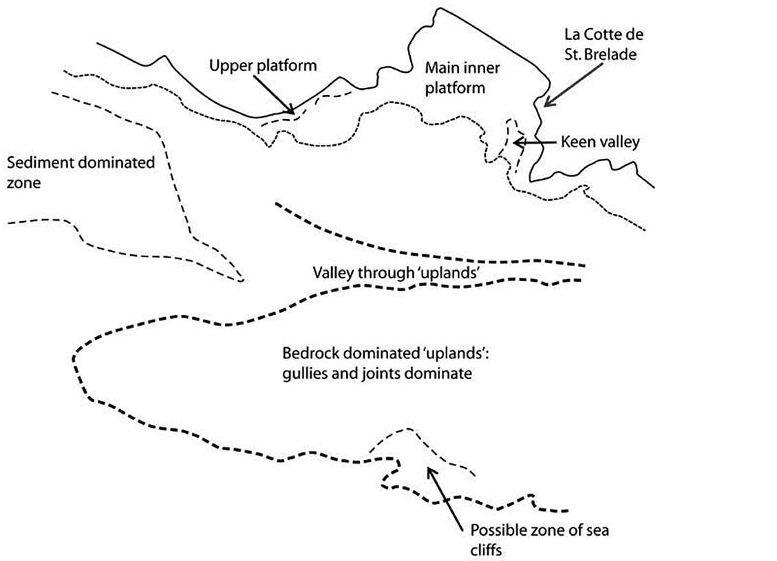
Geomorphological interpretation of the seabed topography south of La Cotte de Saint Brelade, Jersey.
Photo and text: Bates (2011)
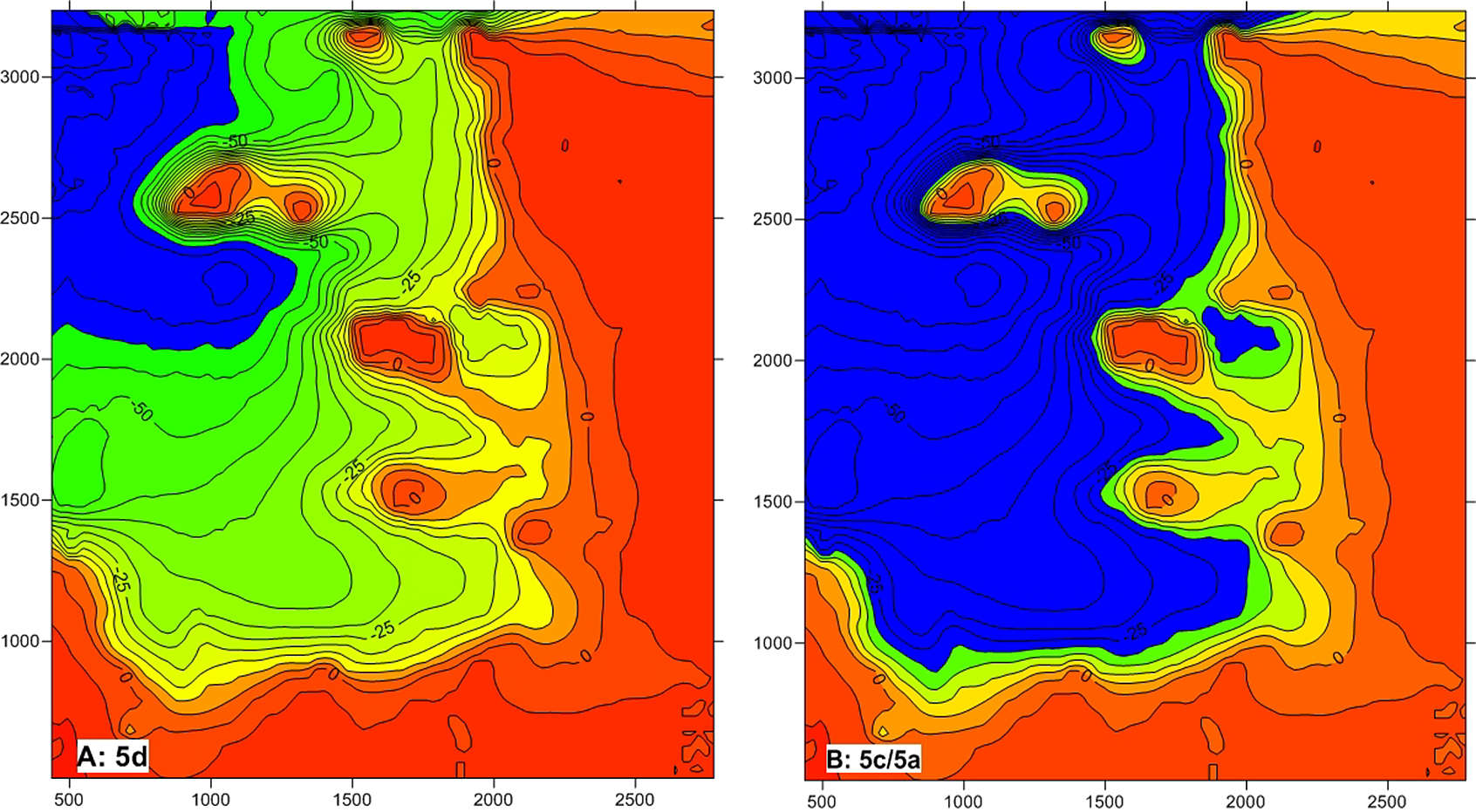
Topography of the seabed around the Channel Islands showing the position of the coasts during
A: MIS 5d
B: MIS 5c/5a.
Equivalent dates:
MIS 5d 115 000 BP cooler
MIS 5c 106 000 BP warmer
MIS 5b 93 000 BP cooler
MIS 5a 85 000 BP warmer
Photo and text: Bates (2011)
Additional text: http://archaeology.about.com/od/mameterms/a/Marine-Isotope-Stages.htm
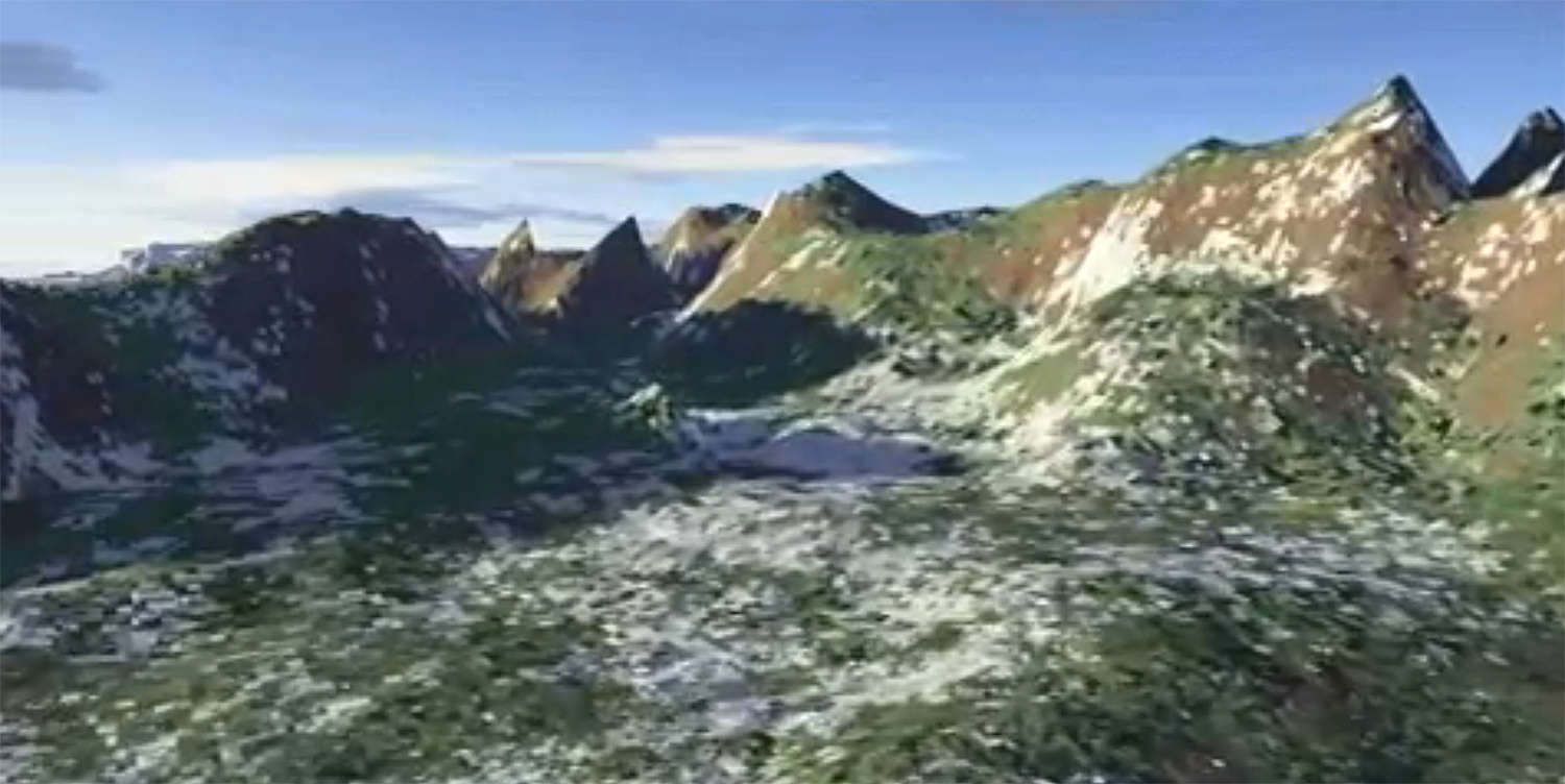
Terragen reconstruction of the Keen Valley, leading towards La Cotte, taken from terrestrial and bathymetric data from the vicinity of la Cotte de St Brelade, Jersey.
Photo and text: Matt Pope, https://www.youtube.com/watch?v=hHOGCQd1o1o
Apart from their peculiar arrangement, the fact that there were relatively large numbers of young and prime-aged mammoth and woolly rhino indicates that the remains reflect a living herd structure. Scott (1980)noted that solitary young rhinos are frequently found at the edge of modern elephant groups. Thus the bone heaps are most likely to represent the residues of a mass kill rather than individual episodes of hunting.
Scott (1986b) noted that, in addition, the parts of the skeletons represented in the two bone heaps are different. Layer 3 is dominated by head elements, pelvic bones, scapulae and some forelimb elements, while layer 6 is mostly composed of scapulae and pelvises, and femurs.
Scott et al. (2014) note that all of these skeletal elements are heavy, and such elements are not usually transported away from a kill/butchery site. Scott (1986b) interprets this to mean that although the heaps represent the remains of butchering fairly complete mammoths, since the excavated areas in each case are small, only specific parts of the butchery floors were exposed. Thus limbs might be processed in one area, and heads in another.
A wounded but not disabled mammoth would have been a formidable opponent for a hunter.
Photo: Smith (2010)
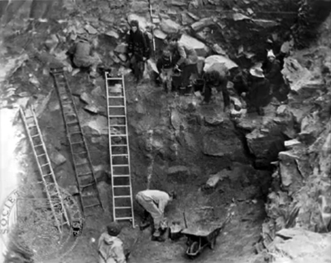
First Excavations at La Cotte de St. Brelade
The cave is situated on the South-western side of the island, in the Eastern horn of the Bay of St Brelade. At this part of the coast, the cliffs, which are of a coarse grained syenitic granite, rise more or less vertically to an elevation of about 200 feet (60 metres) above mean tide level, and the shore at their base consists of flat granite rock, covered for the greater part with large boulders which have fallen from the cliffs.
In one part of this coast there is a gorge 40 feet (12 metres) in width, which enters at right angles to the shore line for a distance of about 150 feet (45 metres). This has vertical walls, exactly parallel with one another, and it is in one of these wall, the one with the southern aspect, and near the inner extension of the gorge, that the cave is situated.
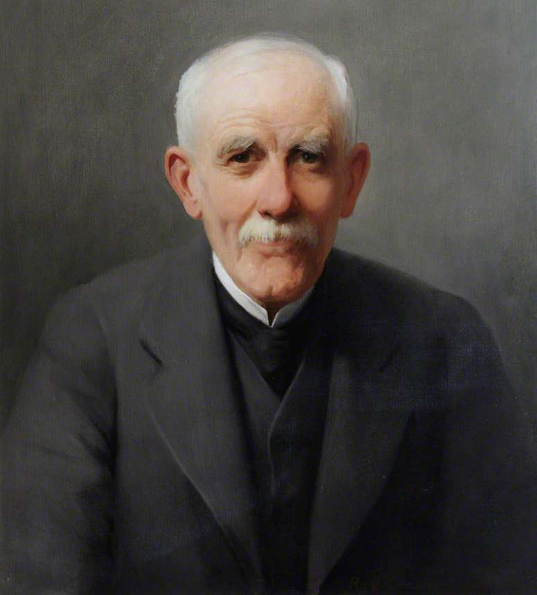
Joseph Sinel, Museum Supervisor (1910–1929), oil painting from 1921
Joseph Sinel (b. December 13, 1844 in St Helier, d. Jersey – 1929) was a naturalist and archaeologist. In 1907 he became curator of the Société Jersiaise Museum, a post which he held until his death. Most of the zoological exhibits in the museum were his handiwork.
Photo: Richard Goldie Crawford
Text: Mostly adapted from Wikipedia
Source: http://www.bbc.co.uk/arts/yourpaintings/paintings/joseph-sinel-surveillant-du-musee-19101929-137112
The gorge, like the cave itself, was evidently formed by the removal by wave action of a dyke of granite which was of less resistant structure than that on either side of it, and in which the lines of cleavage were horizontal.
(it may simply have been a joint pattern in the granite, with that section of granite eroding away. If there was a dyke at all, it may have been of granite, but it could also have been of another material entirely, such as dolerite, a coarse grained version of basalt. In a circumstance like this, with dolerite, you are likely to get horizontal hexagonal columns as the magma cools, which are then available for erosion - Don )
It is very probable that the cave once extended right across the gorge with its opening facing seaward, and that the portion which forms our present day cave is a lateral branch of the original.
The inner boundary of the gorge is now in the form of a steeply sloping talus, consisting of a mixture of yellow clay or brick-earth and angular masses of granite.
The cave itself, that is, the portion which still exists, was up to the time of exploration completely filled with the same material as that which forms the talus, viz., a lateral spread of the talus, blocks fallen from the roof, and rubble which had access through an aperture, or chimney in the roof.

Mousterian Cave dwelling, 'La Cotte', St Brelade, during exploration (left) and from the tide margin (right).
Photo and text: Sinel (1914)
It would appear that even quite recently, in a geological sense, the gorge had been completely filled with rubble, and that it was through a sapping of the base of this mass, resulting in a downward slide, that the opening of the cave was revealed.
For what long ages the cave had been thus filled and sealed up, will be better understood when we consider the general geology of the island. Here it will suffice to say that the source whence this clay was derived is not now possible to trace, for the district for a mile or more around is flat, heather-clad moorland, without clay, and consists simply of granite, with a thin layer of soil resulting from the decomposition of its scant vegetation. Further, both the gorge and the cave are in a spur of cliff between which, and the actual tableland, there is a depression some thirty feet (nine metres) in depth.
The first intimation we have of this cave having been a human dwelling dates from about 1880, when Mr S. Dancaster and the late Mr T. Saunders, when studying the geology of the district, found a flint implement on the shore at the foot of the talus, and tracing its source, came upon a portion of the hearth which was exposed in section. Searching this, they found many flint chippings and some bits of bone.
La Cotte de St Brelade as it appears now from the sea, at mid tide.
Photo: http://jouault.wordpress.com/tag/jersey/
Various investigations of the section representing the hearth, by Dr Chappuis, Mr Colson, Capt. Rybot, and other members of the Société Jersiaise, resulted in the discovery of several implements and more bone fragments, but the loose condition of the superimposed mass of clay and boulder rendered this work so dangerous that it had to be discontinued.
In 1895 the Société Jersiaise employed workmen and commenced the work of clearing out the cave from the top. Owing to the threatening condition of the whole of the surroundings, it was found that a full exploration would entail an expenditure greater than could then be incurred, so the work was postponed.
In September 1910, exploration was resumed, experienced quarrymen being engaged for the work.
After a few weeks' labour, sufficient of the rubble filling had been removed to lay bare a portion of the floor 11 feet (3 metres) square, to form a platform so as to afford footing on the outside, and to give some idea as to the extent of the cave.
La Cotte de St Brelade.
This may be from the 1968 dig in which Charles, Prince of Wales, took part.
Photo: Société Jersiaise
Source: Natural History Museum video
The entrance, which is in the form of an irregular half arch, is 25 feet in height and 20 feet in width (7.6 x 6 metres).
Just within the entrance, the roof slopes upwards into a rough dome, some 30 to 32 feet (9 to 10 metres) high. How far the cave extended rearward could not however be ascertained, for many hundreds of tons of the filling rubble still occupied that portion from floor to roof.
The floor proper was not clearly defined, for layers of black soil which proved to be a combination of ashes, carbonised wood and clay, were mixed up with whitish bone detritus, the whole forming a semi-solid breccia. Flint implements and flint chippings occurred plentifully all through these layers.
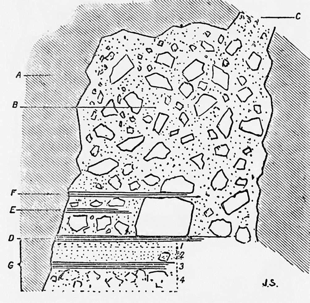
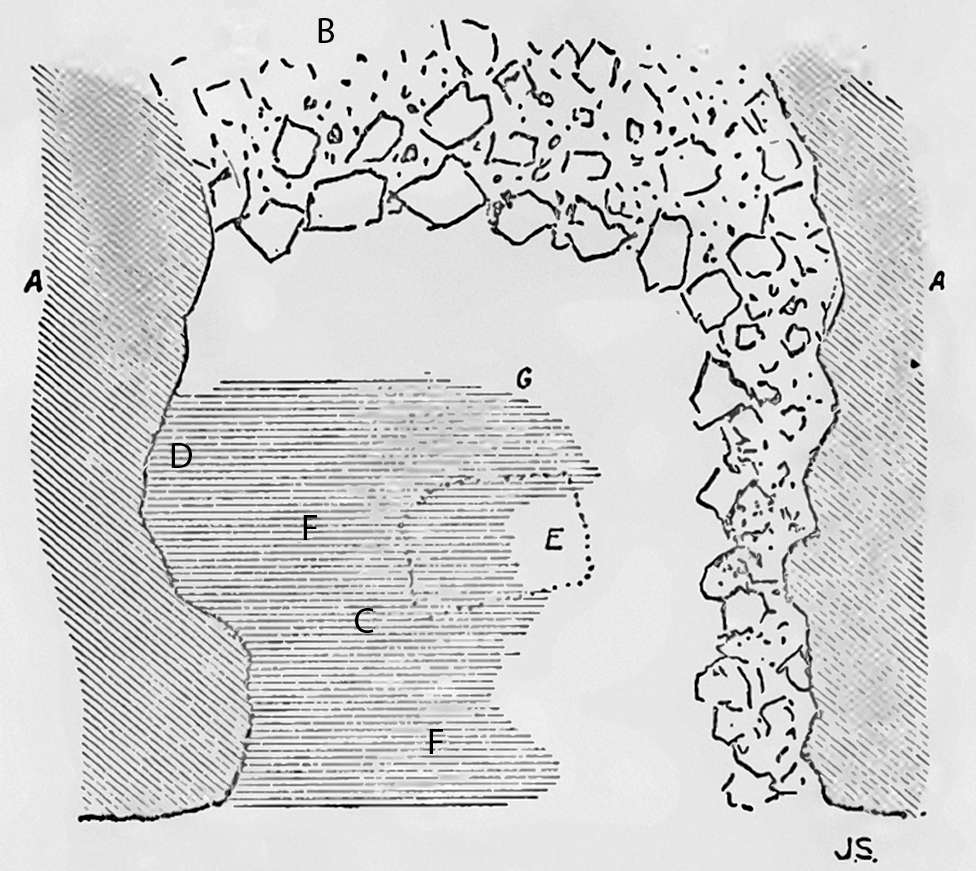
Synthetic vertical section, 'La Cotte', St Brelade, and its contents at 11 feet (3.5 metres) from the entrance, and parallel to the entrance.
A. Granite Rock.
B. Rubble of yellow clay and stone fragments, (now removed to 25 feet from entrance).
C. Opening, apparently communicating with ground level above cave. (Choked with rubble).
D. Main hearth, with abundant wood and bone ashes. Fragments of bone abundant, teeth of reindeer, woolly rhinoceros, bos, horse, and of small bovid {? Capra antiqua ). Flint implements plentiful. Level of original occupation.
E. Continuation of hearth over fallen rubble. Bone and teeth as above, plus Human teeth. Flint implements fairly numerous.
F. Continuation of hearth over another fall of rubble. Bones and teeth of horse and bos plentiful. Bases of horns of a very large deer ( ? Cervus elephas ) Molar of woolly rhinoceros. Flint implements scarce.
G. Portion excavated beneath main floor level:
1. Thin layer of yellow clay and a few stone fragments.
2. Finely disintegrated granite, 1 ft. to 2 feet thick.
3. Black layer, 1ft. to 1ft. 6 in. thick, composed of vegetal and animal remains, branches of elm with ivy attached. Fragment of fossilised bone (not determinable).
4. Whitish unctuous clay and stone fragments. (No signs of human occupation below D).
(note that I have been unable to identify the species Capra antiqua listed here, and it does not appear in modern lists of the species found at la Cotte de St Brelade - Don )
Photo and text: Sinel (1914)
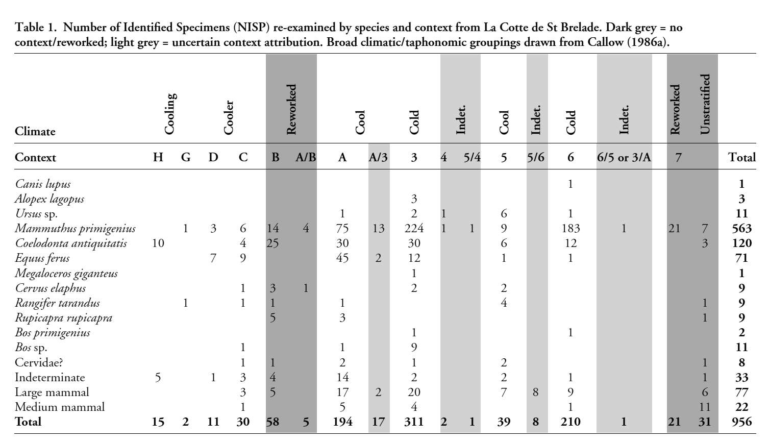
Number of Identified Specimens (NISP) re-examined by species and context from La Cotte de St Brelade.
Dark grey = no context/reworked; light grey = uncertain context attribution.
Broad climatic/taphonomic groupings drawn from Callow (1986a)
Photo and text: Scott et al. (2014)

Red Deer Stag, Cervus elephas.
Picture taken during rut (mating season) in Jægersborg Dyrehave in Denmark, 26 September 2009.
Photo: Bill Ebbesen
Permission: Creative Commons Attribution 3.0 Unported license
On the left of the entrance, and extending as far back as floor had been reached, was a hearth containing half a ton or so of wood and bone ashes, and among the ashes were many granite and felsite pebbles which bore signs of having been strongly heated, and which had probably been used for water boiling purposes, after the method of some savage races of the present day, who, in default of boiling vessels, drop heated stones into gourds of water.
Bone in abundance was scattered all around, forming cheesy, clayey deposits, offering no determinable portions.
Just behind the hearth, however, in a receding angle in the wall rock, a mass of bone offered some fairly coherent portions, as well as some teeth. These were carefully removed and packed in soft material, then infiltrated with gelatine and hardened.
These fragments were forwarded to Drs Woodward and Andrews, of the British Museum, for identification and were shown to represent the following animals, viz.: woolly rhinoceros, reindeer, a large species and a small species of horse, some small bovid, probably the primitive goat Capra antiqua, and urus, Bos primigenius. (The teeth of this last were abundant). Portions of antlers as well as teeth of reindeer, and the horn cores of a small bovid were also among these.
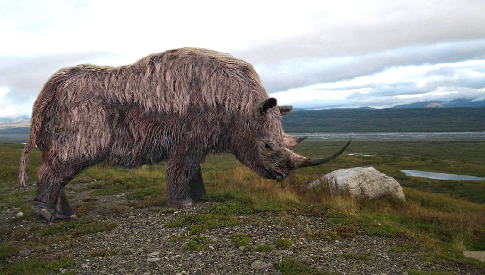
Woolly Rhinoceros, Coelodonta antiquitatis
Photo: Philip72
Permission: Creative Commons Attribution 3.0 Unported license.
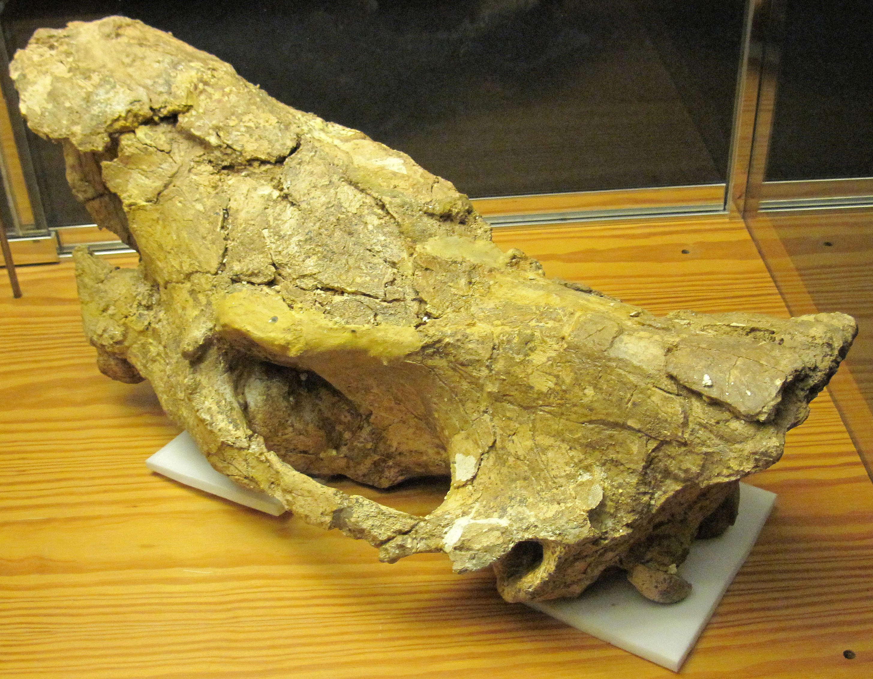
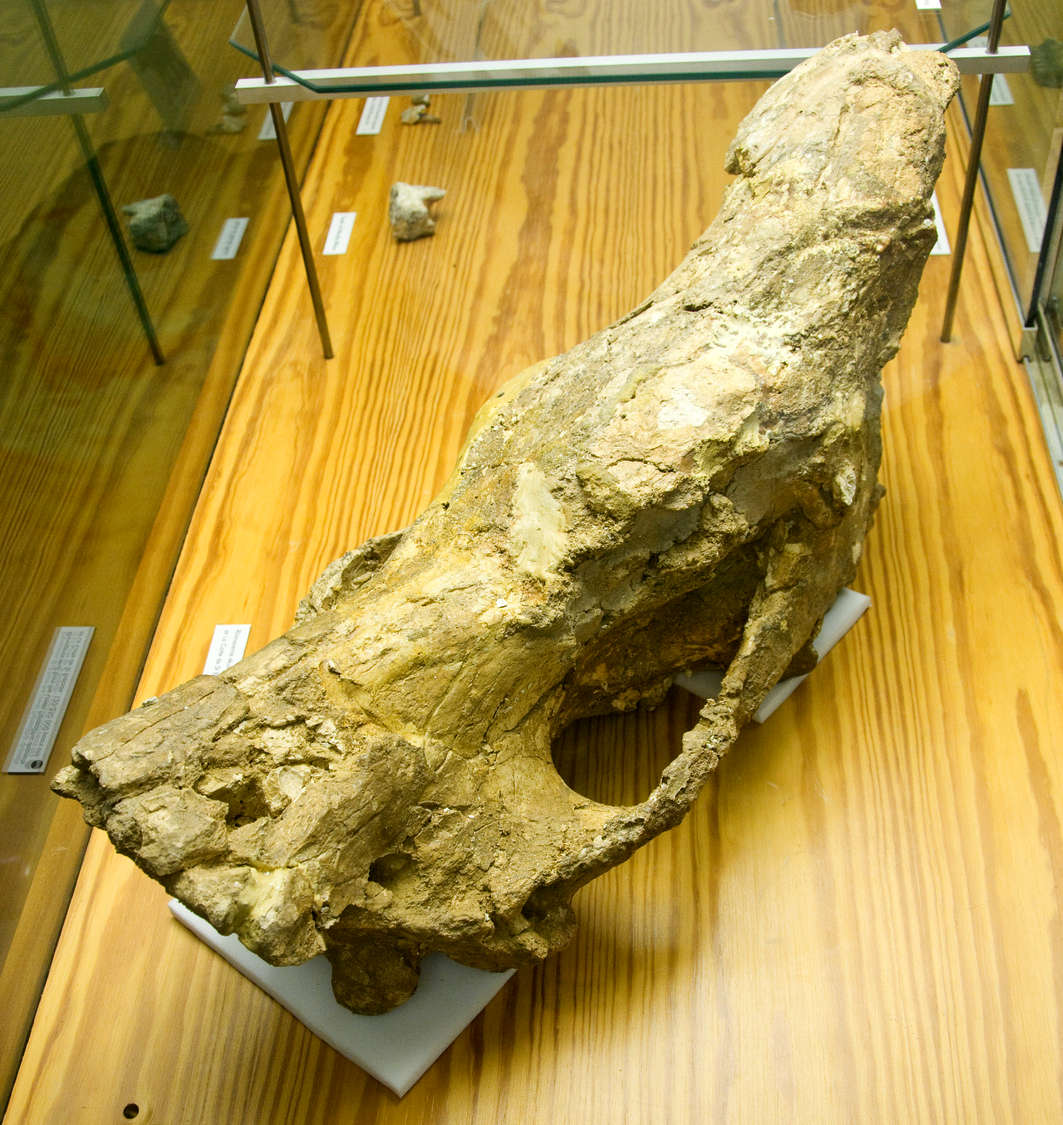
Woolly Rhinoceros skull, Coelodonta antiquitatis, from the Lower Palaeolithic deposits at La Cotte de Saint Brélade. 120 000 - 250 000 years old.
An exhibit in La Hougue Bie Museum, Jersey
The poor preservation of these specimens is due to the acidic nature of the deposits, which are derived from granite. Much better fossils would have been recovered if it had been a limestone cave.
Similarly, one might hope for, but could not expect, good hominin fossils for the same reason.
Photo (left): Man vyi
Permission: Public Domain
Photo (right): © Steve Greaves via Flickr
Besides these animal remains, in the same recess were nine human teeth of unusual proportions. These were forwarded to Dr Keith, of the Royal College of Surgeons' Museum, who recognised them at once as those of a Neanderthaloid man.
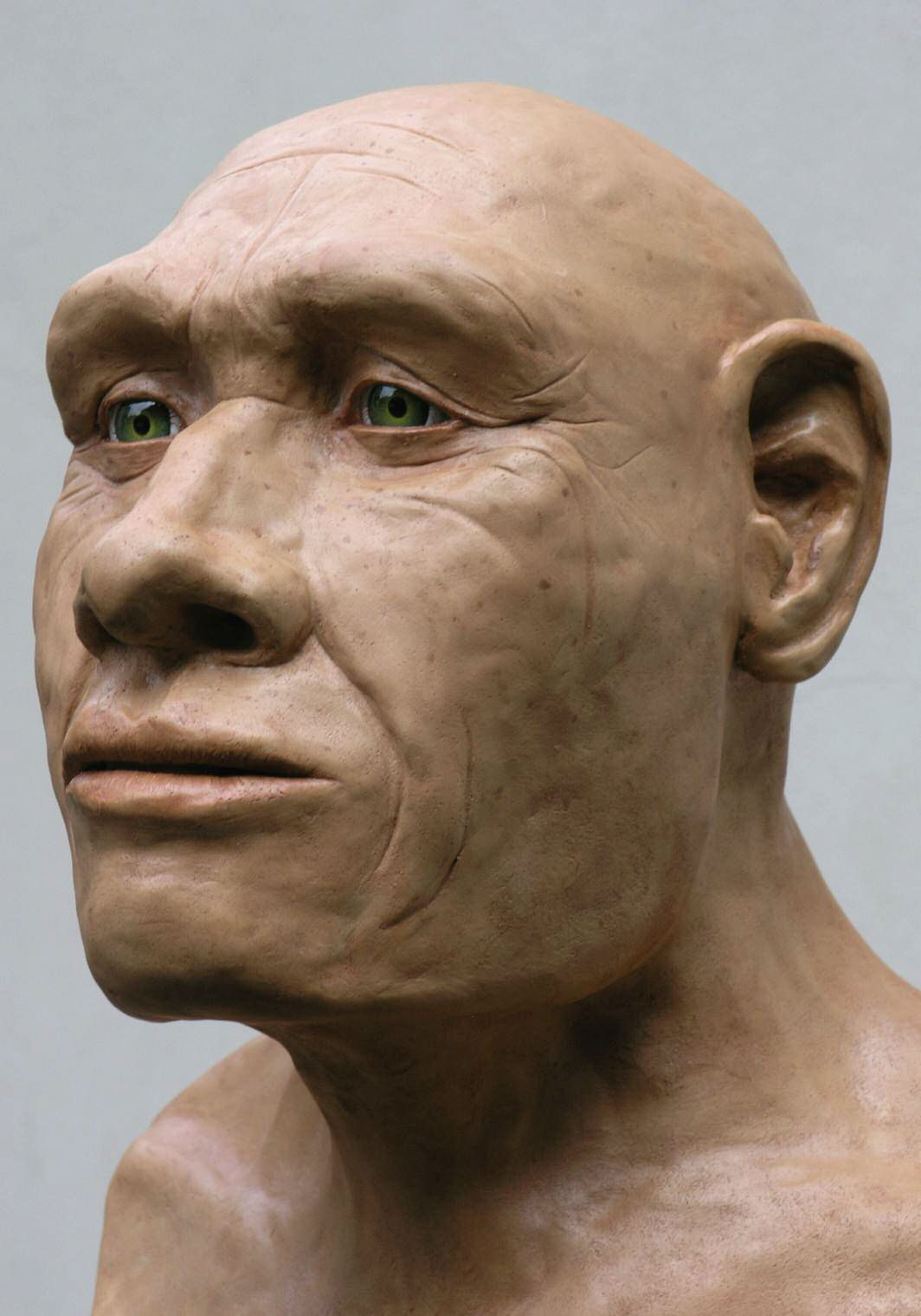
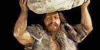
Model of a Neanderthal.
Photo: Finch (2008)
Of flint implements (all of one form, the typical Mousterian Pointe à main ), about 200 were obtained, also many pebbles with abraded ends, which had apparently been used for pounding or grinding food material, also very likely as hammers for flint chipping.
At this stage the engineer in charge of the work considered that it would be prudent to postpone further clearing out of the rubble until some method of propping up the now unsupported roof had been devised, so the work was suspended.
In 1911 exploration was resumed and a portion of floor 25 feet by 20 feet (7.6 x 6 metres) was laid bare. In the centre of the space thus cleared was a block of granite 8 x 5 feet (2.5 x 1.5 metres), weighing approximately 14 tons. This block was at first considered unnecessary to remove, but as the floor was being dug and examined, it was found that the hearth extended underneath it, whilst the presence of a layer of ashes, bone and flint chippings on the top, showed that this huge stone had fallen from the roof during the period that the cave was occupied.
In fact, the lower, and original, hearth could be traced upwards in stages, showing that repeated falls of roof and rubble had taken place during the time of occupation.
Plan of floor of 'La Cotte', St Brelade, as explored up to Sept. 1911.
(note that I have relabelled some of the positions of the deposits which were almost illegible on the original - Don )
A. Granite Rock.
B. Rubble as yet unexplored—(backward extension probably twenty feet).
C. Main hearth.
D. Where bones and teeth were most plentiful. Human teeth at this spot, 3 feet above the level here shown.
E. Large block fallen on hearth, (now removed).
Lower F. Flint implements abundant.
Upper F. Flint implements scarce.
G. No flint implements found beyond this point.
Photo and text: Sinel (1914)
The relics discovered in this resumed exploration were, with the addition of the bases of the antlers and portion of the skull of a large deer, the same as those previously found. At the spot where the nine human teeth had already been found, four others were now discovered, raising their total to thirteen. These, Dr Keith pronounces as all belonging to one individual. These teeth are the subject of a monograph by Drs Keith and Knowles, in which their similarity to those of Krapina and with those of the Heidelberg jaw is pointed out.
How far the cave extends backwards was not ascertained, but judging from the slope of the roof, which at 30 feet (9 metres) from the entrance begins to lower, it is probable that some 50 feet (15 metres) is the full extent.
About another hundred flint implements were discovered at this stage.
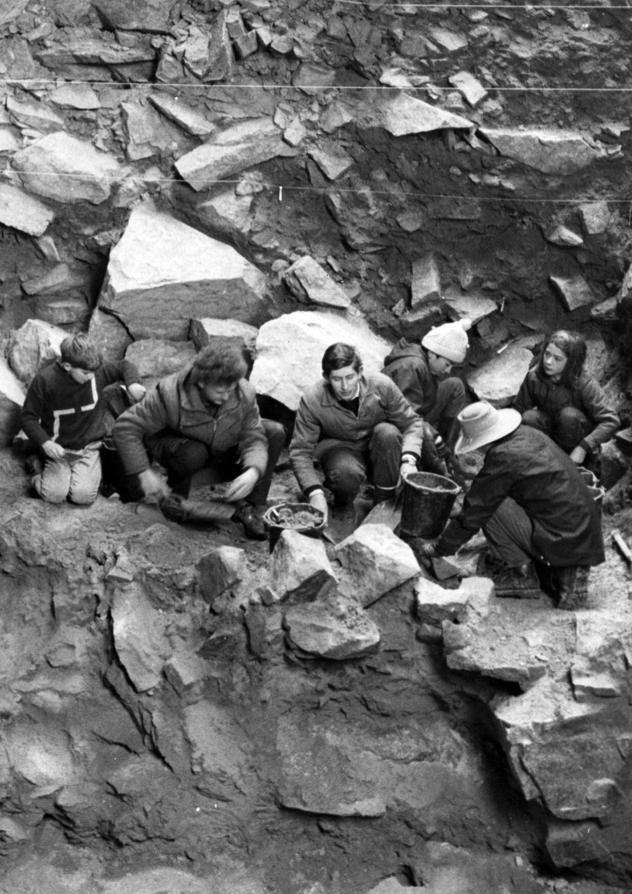
Prince Charles during the 1968 excavation.
From another source, from left to right, the son of Charles McBurney (Simon), Anthony Legge and the student Charles, Prince of Wales.
Photo: Jersey Evening Post
Source: Finch (2008)
On the opposite side of the gorge, facing the entrance of the cave and almost entirely concealed by the sloping talus which forms the termination of the gorge, was indication of another cave. This was investigated by Mr G. De Gruchy, the proprietor of the site, and Mr R. Marett, in 1912, and the result of their investigation communicated to the Société Jersiaise, of which Society both these men are members. It was then seen that this second cave was a branch of the first, that is, a large cave must at one time have existed in the site of what is now the gorge, and of which the two caves which are now facing one another, were lateral branches.
No hearth, or bones except in small fragments, occurred in this portion, but about a score of implements similar to those already described, were brought to light.
The exploration of La Cotte then, whilst it may be considered still incomplete, has proved highly interesting, as beyond the discovery of the remains of a man of the Mousterian period, it has furnished the first evidences of a Pleistocene fauna in the Channel Islands. Apart from those found in these caves, unmistakable implements of Mousterian man occur in considerable numbers between the upper and lower boulder clays both in Jersey and Guernsey.
The human teeth - all that was left of what must have been a skull - were found, not in the position in which their owner may have died or had been reverently laid, but against the wall rock of the cave, behind the hearth, and mingled with broken bones of ox and reindeer.
The occupants took some thought for the morrow, and we found remains of wood, including large boughs, stacked near the hearth.
Résultats des fouilles récentes (1951-1956) à la grotte de la Cotte de Saint-Brelade à Jersey
Burdo (1956)
Translation: Don Hitchcock
On the 22nd February 1951 I communicated with the Society on the progress in this cave (Hull. Soc. préhist. fr.t juillet-août 1951, t. XLVI1I, 7-8, p. 322). At that time I dated the deposits as being Mousterian.

The Levallois (Mousterian) technique animation for a blade (left) and a point (right).
Click on the images to expand and view the animation of how the techniques are performed.
Photo: José-Manuel Benito Álvarez
Permission: licensed under the Creative Commons Attribution-Share Alike 2.5 Generic license.
This is a typical and rather large (9 cm long) Mousterian point, from the Middle Paleolithic in Europe (250 000 - 40 000 BP). A small impact fracture is present at the tip. It is a 19th century find from Treon near Dreux in the Bretagne.
Photo and text: http://www.aggsbach.de/page/42/
Four months later, in July 1951, and most unexpectedly, I had to change this assessment. To the somewhat schematic stratification at that time in which I listed only the layers, I have today added a detailed longitudinal section with a descriptive caption.
None of the previous excavations from 1910 to 1917 and from 1936 to 1940, had penetrated below the head (layer 0 B), in the final metres of which were found all the Mousterian tools and fauna. They had stopped, without crossing, in a peaty soil (layer 2A), which was completely sterile in bone and lithic implements, rich in plant materials but very poor in pollen.
(It should be noted that at this time one of the few ways of dating a site independently of tool styles was by pollen. The lack of pollen is puzzling here, because it is well preserved in most such deposits, and especially so in peat - Don )
My first surprise was to find under this layer, not a marine sand, which had been expected, but a white clay (3B) very pure and fine, that Prof. Deflandre, Director of the Laboratory of Micropaleontology of l'Ecole des Hautes-Etudes, identified without hesitation as a freshwater deposit with diatoms (a major group of algae, and among the most common types of phytoplankton, found in oceans, freshwater, in soils and on damp surfaces ), many siliceous cells of grasses and many crustaceans. The average depth was one metre. The presence of fresh water deposits was soon confirmed by the discovery of an underlying coarser and highly ferruginous sand.
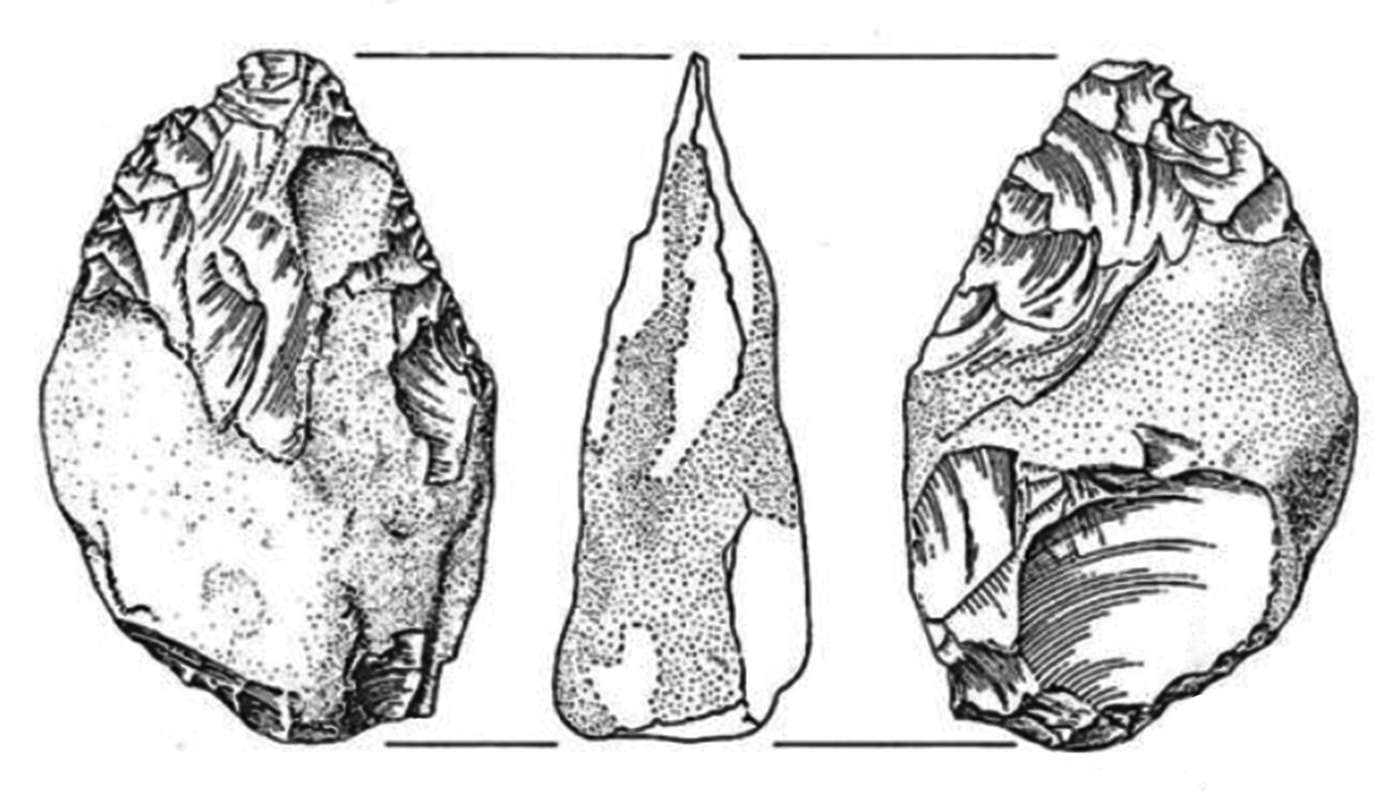
Slightly rolled amygdaloid hand axe from the Burdo excavation.
From Layer 3B (i.e. 8.3) 4.0 metres outside the entrance of the north ravine, 10 cm from the wall of the north pinnacle, at 27.3 metres below datum.
Photo and text: Callow and Cornford (1986)
Slightly rolled amygdaloid hand axe from the Burdo excavation.
From Burdo's 'Acheulean 1' (i.e. 8.1) at the entrance to the north ravine, 4.4 metres from the west wall, at 26.5 metres below datum.
Photo and text: Callow and Cornford (1986)
Below this was another bed of old vegetation (6), less peaty than 2A, but indisputably of vegetation because of the many imprints of the roots of herbaceous plants and, it seems, shrubs.
Then there was another change at 5B, with fragments of a loam, which since they were separated from the more recent loess several metres above by the various deposits that I just mentioned, could only be older loess.
Near the entrance to the cave, to the right of the section, this was absent, and I found a light reddish brown clay that reminded me immediately of the red clay cap in the valley of the Somme on the old loess there. At the same time, while for layer 1 there were still a few remnants of the Mousterian, all subsequent layers were sterile, flint now reappeared in abundance, both tools and flakes.
Soon the materials, forms and techniques led me to a conclusion which was inescapable: I was dealing with the Acheulean, and given the abundance of debitage, it was the site of a workshop, an atelier.
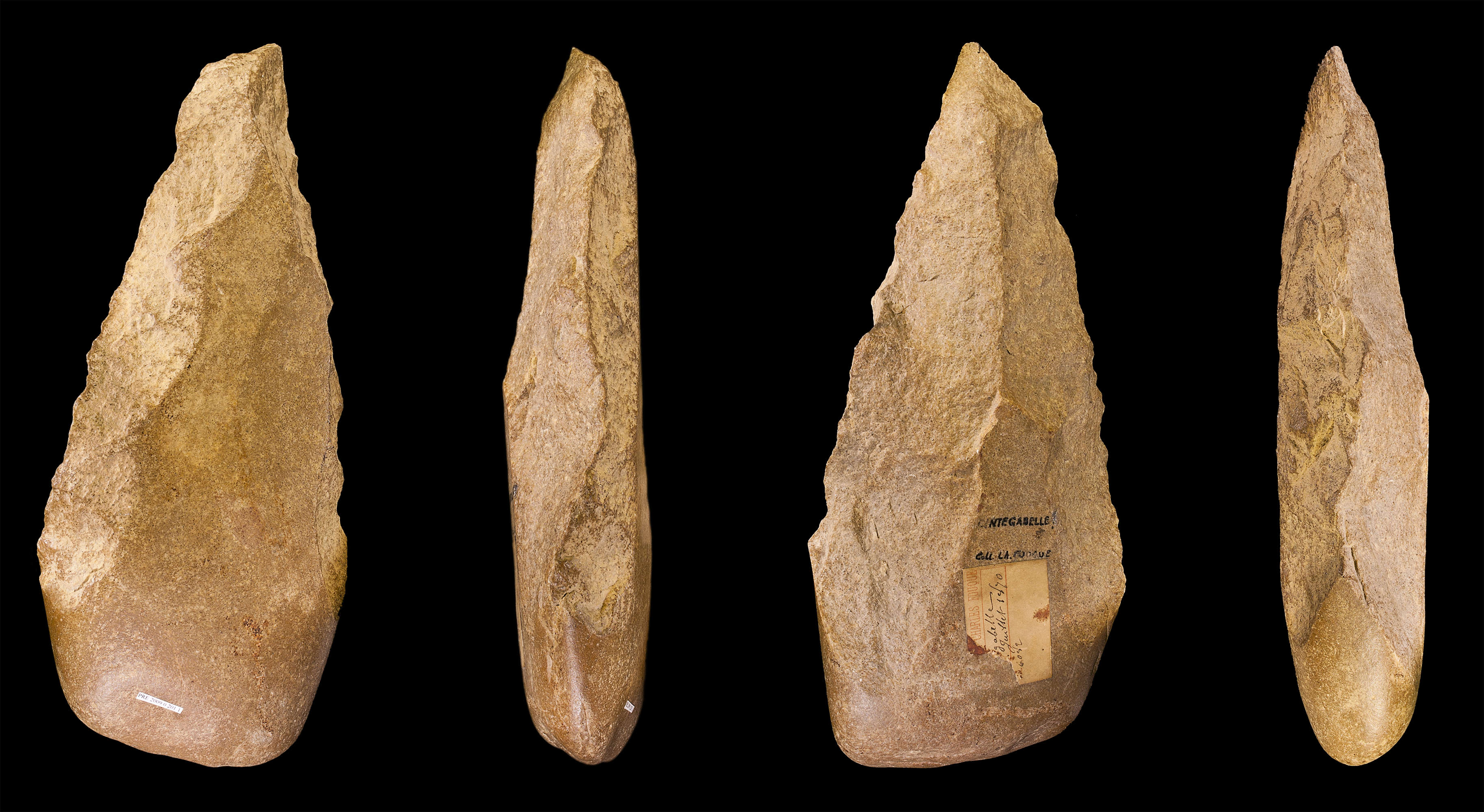
Acheulean hand-axe
Acheulean tools are typically found with Homo erectus remains.
Date: between 500 000 and 300 000 BP
Medium: chert
Dimensions: 268 × 120 × 55 mm (10.6 × 4.7 × 2.2 in)
Current location: Museum of Toulouse MHNT PRE.2009.0.201.1
Place of discovery: Sainte-Gabelle, Haute-Garonne, France
Collection of Charles Fouque
Biface from Cintegabelle, France
Photo: Didier Descouens
Permission: licensed under the Creative Commons Attribution-Share Alike 3.0 Unported license.
The 'red clay' was not very thick, 1 metre at most. I worked on it conscientiously for a little over a year and had already penetrated deep into the underlying typical loess. Towards the end of 1952, in order to reach some bone fragments that seemed interesting, I dug down into the face of the dig, to just under the level of the floor of the trench.
Through this window, there appeared to be a very dark earth, filled with bone fragments and burnt wood and fragments of flint.
I immediately took up by the work of exploration, and in a few months I found myself looking at an almost vertical bed of ash (7C to 7F) three metres wide, and with a uniform thickness of approximately 350 cm, interrupted only at 7D by a thin bed of loess no trace of fire.
The cave had been, over a time which I could not even hazard a guess, a home as well as a workshop.
Currently, the face of the dig has the horizontal dimension of 5 metres, at a distance of 7 metres inside the cave. It is 5 metres wide, and 5 metres high, containing 350 cm of ash topped by 150 cm of loess, the whole layer being Acheulean.
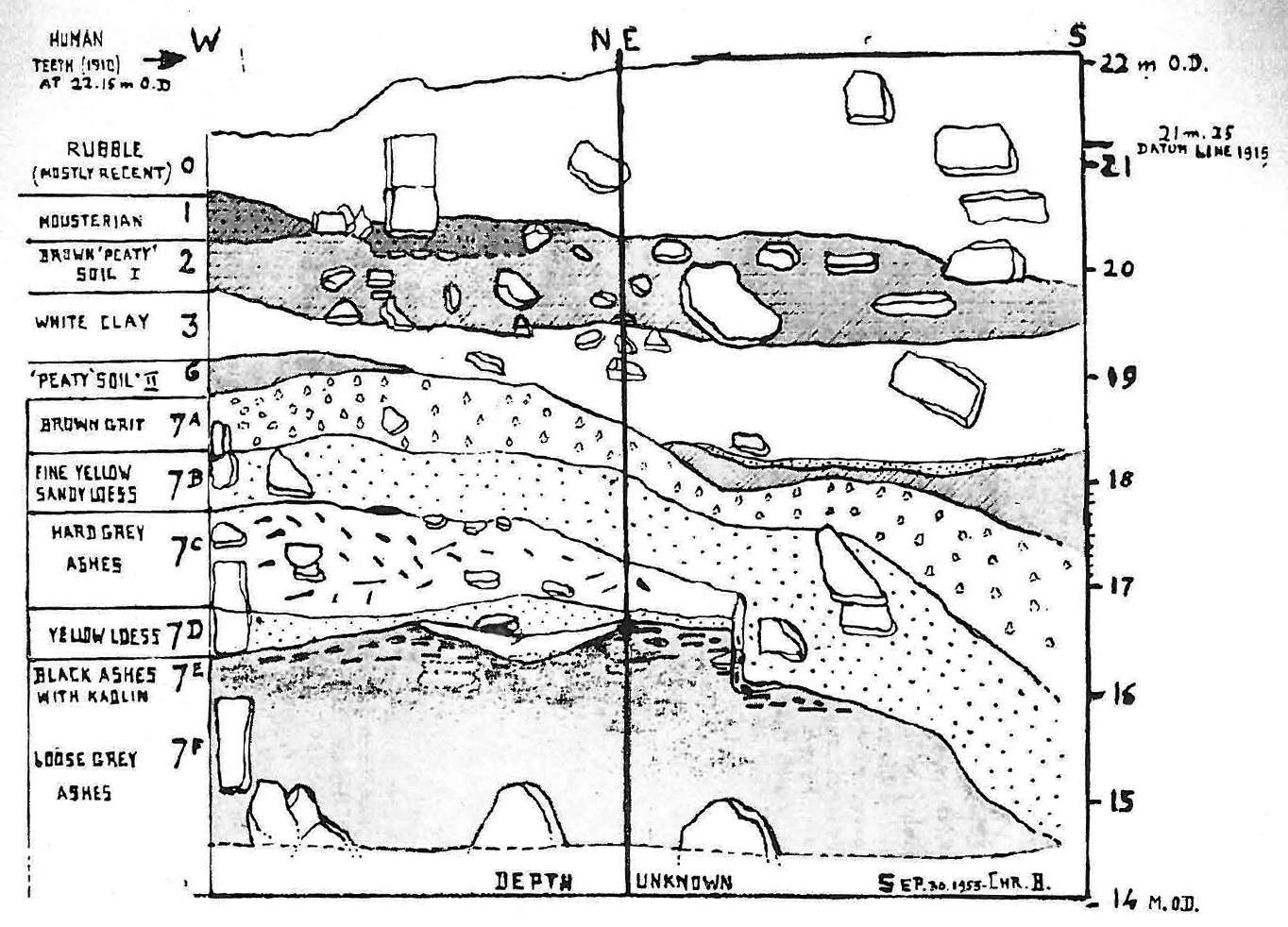
Longitudinal Section
Modern and Mousterian levels
ОА: Excavation and recent scree
ОB: Head. In its lower part (1) are found Mousterian tools and fauna
2A: Sandy dark brown peat from ancient vegetation
2B: Coarse brown sand
3A: Very fine aeolian (wind blown) sand
3B: White freshwater clay
4: Ferruginous sand
5: Gravelly sand
5B: (5A? - Don ) Compact loess (loam?) often stratified
Acheulean levels
5B: Orange discontinuous lines, at the top of the human occupation.
5C: Human occupation
6: Old floor, slightly peaty
7A: reddish gravelly clay
7В: Old loess
7С: Very hard grey ash, with charcoal and tools
7D: Band of layered loess
7E: black ash, with charcoal and tools (hearth ?)
The cave entrance arch, 15 metres high, is in alignment with the longitudinal dimension.
The general direction of the coupe is from left to right, North-South. Lengths and heights in metres.
OD (Ordnance Datum) is the datum or zero from English maps, halfway between high and low tide.
Photo: Burdo (1956)
Tools and other artefacts
| Tools | |
| Description | Total |
|---|---|
| Bifaces (Hand Axes) | 119 |
| Flat, discoidal tools | 429 |
| Blades with flattened faces | 1 569 |
| Points | 141 |
| Quartz tools | 437 |
| Archaic technique | 545 |
| Scraper-knives | 274 |
| Backed knives, cutting blades | 2 738 |
| Blades with a triangular cross-section | 2 064 |
| Scrapers, all types | 2 752 |
| Hammers and hatchets, granite | 563 |
| Hammers, schist and dolerite | 313 |
| Hammers, quartzite | 242 |
| Special tools | 636 |
| Total | 12 822 |
| Other artefacts | |
| Description | Total |
|---|---|
| Core / nucleus | 1 251 |
| Flaked pebbles | 163 |
| Used flakes | 4 651 |
| Shards, waste, debitage (approximated by weight) | 30 300 |
| Total | 36 329 |
We can make the following remarks about the forms and techniques:
1. The flint bifaces are more numerous in the more recent layers; in the oldest, quartzite, dolerite and metamorphic schist dominate. All are remarkable for the care to ensure a good grip and not to hurt the hand. Even a dimple or depression is often provided for the thumb or index finger. This suggests, first they were made for direct use in the hand without a hole for a handle, and secondly that the hand of the Acheuleans did not differ appreciably from that of a current average man. This is important.

Biface in dolerite. Face and left profile.
Photo and text: Burdo (1956)
2. It is remarkable that several times, in the middle of waste piles, we found an abnormal density of quite small bifaces, 6 or 7 cm, made of diabase (dolerite) or schist.
3. As the depth increases, so also does the number of tools in granite found at the site. Most are choppers, large hammers of a very constant type: one face flat, the other with a central reinforcing ridge. One larger end with a bevelled facet for gripping, the other narrow end often crushed or broken through use. Dimensions were very variable, between 30 cm and 5 cm.
4. There were many cleavers, though a little fewer in numbers than choppers. The material is still either local granite, or grey quaurtzite, very hard and abrasive. Forms can be reduced to two types: one similar to that found by Mlle Alimen in Layer II of Kerzaz (Western Sahara) and published in Bull. Soc. préhist. fr. , December 1955, p. 486 , Fig. 5, the other with a sort of elongated handle, analagous to an example from Ternifine (or Tighenif) in Algeria, shown during a meeting by Professor Arambourg, and two others, found also in Northern Africa by our colleague B. Champault.
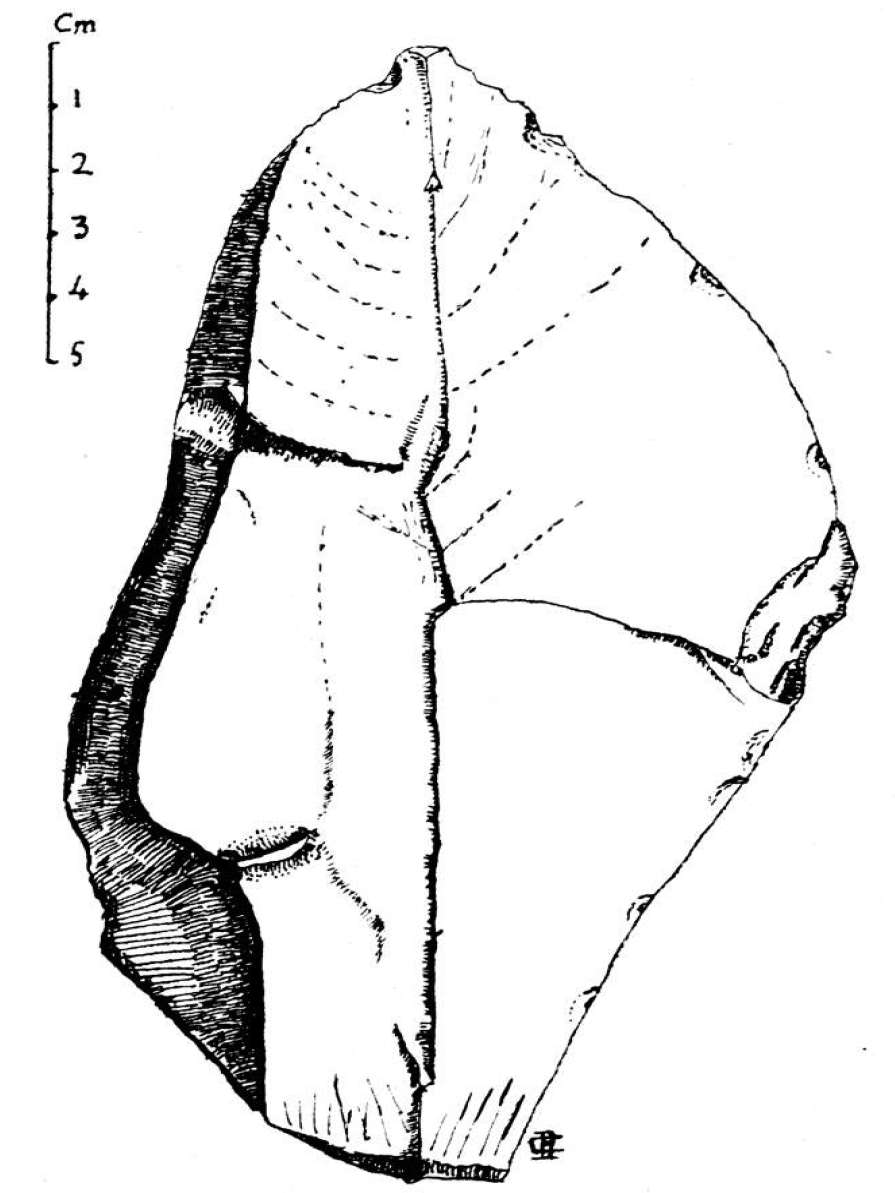
Cleaver in light grey fine-grained quartzite. The underside is without any retouching. The impact point, without facets, is on the lower end.
Bulb slightly protruding.
Break angle: 130°
Photo and text: Burdo (1956)
5. Scrapers form the most numerous class of tools. Almost all known types are represented: retouches on one or both ends, one, two, three or four edges, convex, concave or straight. Retouches, often very steep, are often made with delicacy and perfect regularity, but, which is still typical of the period, the body of the tool is often overlooked, being shapeless and full of defects .
6. Knives, sharp blades. - These are of mediocre length, rarely exceeding 7 cm. They are rarely retouched, but are extremely sharp - the back always showing the same concern for a convenient grip for the extended index finger, or through the cortex not being removed over the entire length, or by the removal of irregularities and bumps.
It should be noted that, as with scrapers, many knives are obviously designed to be used with the left hand.
7. Knife and scraper pair - We found last year, close to one another, two excellent tools, with striking similarities in size, material, technique and weight, and they were obviously made from the same nucleus by the same skilled worker, but one was a knife, the other a scraper with abrupt retouch. The total weight of the two was: 83g + 85g = 168 grams.
This find drew my attention to another set of tools, found slightly higher, and thus younger, of a tool with two edges parallel or convergent, one worked as a knife and the other as a scraper. There were thus savings in material, and a reduction in weight of almost half. One can not have everything, and the grip was less convenient, but it was ameliorated by a greater thickness of the tool body.
This is an interesting example of the benefits that are provided by the fine perfection of technique by an inventive craftsman, and is another example of the imagination and resourcefulness of the Acheuleans compared with their more traditional and more hidebound Mousterian successors.
This type of tool, relatively common here (n = 274) seems to have been either neglected or rarely found elsewhere in such a remote period, the oldest of which I have knowledge is that reported by Dr. Henri Martin in the Mousterian III of La Quina.
8. Under the heading 'Archaic Technique' I have assigned a number of pieces. Some may be attributed to 'pebble culture', if they were not simply eoliths, not made by man but by nature. Others appeared to be related to the Clactonian type (which seems to have coexisted with Early Acheulean - Don )
As for the Levallois technique, I was able, thanks to the delay in writing this note, to use the valuable article by Abbé Breuil and Harper Kelly which appeared in the Bulletin of March-April 1956: 'Les éclats Acheuléens à plan de frappe à facettes de Cagny-la-Garenne'.
It shone light on a certain number of pieces the facetting of which had intrigued me, but which I was strongly reluctant to classify as being of the true Levallois technique.
I was instead of the opinion that I had the pleasure of seeing what H. Kelley (loc. cit, p 178.) called 'The flexibility of mind and technique of the Acheuleans with respect to the 'best use of various raw materials.' I would add that, upon closer examination of my own pieces, there are many cases where faceting is due to a mistake of knapping, the worker having tried two or three times to strike off a flake of sufficient thickness.
9. The cores are certainly not from the Levallois technique. Often small, always irregular, they had almost all been 'softened', or improved for working, by heat. A good number had been heated too much, fractures or crazing having made them unusable.
10. I had the idea to study on my 1955 harvest of artefacts, the value sometimes accorded to older tools of the simultaneous presence of a smooth striking platform and a high angle of striking. For this I took the pieces from three superimposed layers, a total of one metre thick, and selected from them three groups of 100 pieces each: The proportion of a smooth striking platform with an obtuse striking angle was as follows:
The lower portion, the oldest, had an average of 74.5%, with one batch having a maximum of 95%.
The middle group had an average of 18.8%.
The upper portion, the most recent, had an average of 8%, with one group having a minimum of 0.
I started this experiment without prejudice. Although a single observation cannot create a general law, I admit that the result seemed too neat to be due to chance.
Fauna
Bones are abundant, almost at all levels. Unfortunately acid granitic deposits were their fatal and few are in a state of good preservation. Their comprehensive study and the specific determination is not completed. Here is what seems already assured.Elephas - Fragments of 12 or 14 molars, of which 4 are well preserved, as well as many more single lamellae. All seem to belong to Elephas Primigenius, the Woolly Mammoth. - 4 or 5 fragments of tusks are too incomplete to allow estimation of the curvature.
Rhinoceros - 15 molars fairly complete, as well as fragments of fifteen others. There was one temporal, very well preserved. All the teeth belong toRhinoceros tichorhinus , the Woolly Rhinoceros.
Equus - 11 teeth. A sesamoid bone of the hind limb. The difference in size suggests the likelihood of not only different individuals but different species.
Rangifer - One doubtful fragment of a Reindeer jaw with four teeth.
Cervus - Some articular ends of Cervus elaphus. A phalanx of Cervus Capreolus.
Ursus. - A phalange and a canine of Ursus Spelaeus. An intact incisor of Ursus arctos.
The absence of Felines, and especially Hyenas is remarkable.
In short, the fauna are poor in species, but indicate a moderately cold climate, but without the proper arctic species that characterised the Mousterian fauna of 1910.
Climate and Chronology
1 - Between the Acheulean and the Mousterian : Coupe: Levels 2A and 6 . Very moist, favourable to abundant vegetation of trees and shrubs. Considerable rainfall, causing a lake or large pond to be established on the plateau above, sometimes trickling, sometimes coursing in a waterfall to the bottom, where water collects and drains away at the entrance of the cave at clay 3B, rich in freshwater organisms which are very waterworn and broken in the fall.This climate is pretty much (at 3B?) that of an interglacial, obviously the last. The complete absence of remains of mammals can not be more affirmative. Perhaps this lack is it due to the fact that the sea level has risen, and Jersey found itself once more separated from the Continent and without possible contribution of species and even new individuals . At the same time its greatly reduced area could not provide enough food for larger animals or for men who lived by hunting.
2 - In the Acheulean, the climate was much drier, with strong winds accumulating a sandy loess several metres thick at the bottom of the cave. These winds would be strong enough to give a beautiful lustre to a number of blocks of granite, and to obliterate the faceting and retouching of some flint. This took place irregularly and at intervals, at different levels of human occupation. At different levels, too, even in the ashes, are the impressions and remains of fine roots, due to a grassy steppe vegetation. It also fits well with the visible predominance of herbivorous wildlife.
I barely completed the Pre-Mousterian levels in one quarter of the cave. And in the ravine where it opened I did not even scratch the surface of the continuity of archaeological levels . We see the enormity of the work that remains to be done, and the importance of the results that can be expected. The most 'sensational' would certainly be human remains, plus some more features than what I have - perhaps - provided from late 1955 and early 1956.
Archaeological Report for 1953 at Cotte de St Brelade
Burdo (1953)
(Abridged)
Section across trench at 6 metres inside cave, 30th September 1953.
Stratigraphy - This is a section of the working face at the end of September 1953, when we finished the work of excavation proper and were about to prepare another 'slice' for work in 1954. The present section was drawn after a photograph and represents the boulders to scale in their correct outline and position. Besides, it should actually be folded at a right angle along its central thick line, the left-hand half being perpendicular, and the right-hand half parallel, to the West wall of the cave.
(note that, to me, the right hand half of the diagram would therefore be of the East wall of the cave, not the West wall - Don )
A comparison between the 1952 and 1953 sections shows, besides a substantial increase in thickness of the Premousterian layers, - from 1.80 m to 4.50 - a new feature which has been the all important discovery of 1953. In 1952, we subdivided the layer, rather vaguely, in 7A and 7B, pointing out in the latter a small pocket of black ashes with a few unidentifiable pieces of bone.
Since March 1953 we uncovered progressively, behind a frontage of fine yellow loess 7B, a continuous and complex layer of ashes, 7C, E, F, about 3.50 m thick, running all along the working face and sinking below our trench floor down to an unknown depth. There is a great variety in colour and structure among the different ash layers. It is therefore important to give a more detailed description, starting from the bottom upwards.
Photo and text: Burdo (1953)
| Tools | ||||
| Description | Total 1953 | % 1953 | Total 1952 | % 1952 |
|---|---|---|---|---|
| Bifaces (Hand Axes) | 17 | 0.5 | 48 | 7.9 |
| Flat flake implements | 112 | 3.3 | 76 | 12.4 |
| Cutting blades and tools | 866 | 25.4 | 32 | 5.2 |
| Ribbed (or keeled) blades | 663 | 19.5 | 73 | 11.9 |
| Flattened blades | 450 | 13.2 | 75 | 12.2 |
| Scrapers (all types) | 723 | 21.2 | 52 | 8.4 |
| Points | 55 | 1.6 | 47 | 7.7 |
| Granite choppers and cleavers | 121 | 3.6 | 14 | 2.3 |
| Quartz choppers | 108 | [3.2] | 76 | 12.4 |
| Shale, Dolerite, etc. choppers | 33 | 1.0 | 25 | 4.3 |
| Quartzite cleavers | 63 | 1.9 | 25 | 4.3 |
| Implements of archaic technique | 192 | 5.6 | 67 | 11.0 |
| Total | 3 403 | 610 | ||
| Other artefacts | ||
| Description | Total 1953 | Total 1952 |
|---|---|---|
| Nuclei (Flaked cores) | 429 | 50 |
| Utilized flakes | 1 318 | 377 |
| Chips and waste | over 10 000 | ca 800 |
1. Raw materials used are about the same as last year. Black flint of Mousterian quality is still more infrequent ; and the fine-grained brown quartzite is exceptional: its source of supply abroad had probably not yet been discovered.
Quartz is abundant in the lowest layer 7F; but much of it could hardly be listed as 'implements' and had to be entered under 'utilized flakes' or even 'chips and waste'. We have been rather strict in our verdict in all similar cases.
2. One must remember that we worked this year almost 3 metres (10 ft) deeper in the Premousterian layer. We shall not risk an estimation of the corresponding difference in antiquity; but it should probably be reckoned in tens of thousands of years.
3. Consequently we had to expect some difference in the percentage of the most characteristic types.
The biggest decreases are, in % :
Biface hand-axes fell from 7.9% to 0.5%
Points fell from 7.7% to 1.6%
Quartzite cleavers fell from 4.3% to 1.9%
Increases are still more marked :
Cutting tools increased from 5.2% to 25.4%
Ribbed blades increased from 11.9% to 19.5%
Scrapers increased from 8.4% to 21.2%
These figures show that, when we go back to earlier times, the proportion of implements characteristic of late Acheulian and early Mousterian industry is smaller, while there is an increase in implements of a simpler and cruder make, - cutting tools and rough scrapers-or in those, like keeled blades, which are more remote from the Levallois technique.
Still more remarkable is the rise in the proportion of tools and flakes which show at the same time a wide flaking angle (90° - 125°) and a plane unfacetted striking platform: they rise from 11.5% to 43.4% of the total. Such proportion denotes a strong influence of archaic technique - should we call it Tayacian ? - the same as we pointed out last year in the caves of Et Tabûn (Layer E) and of Pech-de-l'Aze.
4. Subject to these chronological differences, flints occur practically at all levels of the section. But it is noteworthy that in 7E (black ashes) there is a much greater quantity of chips. Palaeolithic man had observed that a moderate heat makes flint easier to split and flake. Sometimes however he could not control his fire; and we have been able to reconstruct several flint cores which burst to pieces through overheating.
But flakes detached [after ] moderate fire action under embers and ashes are extremely thin and still as fresh and lustrous as new. III-Animal remains.- We deplored last year the almost complete absence of bones, especially of big animals. But no sooner had we burst into the ash layers than we were amply rewarded for our patience. Unfortunately more often than not we met with endless trouble in collecting and preserving these precious relics. Bones occurred in four different states:
i - calcinated in an open fire, completely bleached and mineralized
ii - black: probably used as slow burning fuel, giving not enough heat to bum up the whole of the organic substance.
Bones of these two first classes are still tolerably hard, but usually too fragmentary for identification iii - Worst of all: fairly large bones, showing a definite outline ; but the whole mass is, when wet, as soft as butter, turning, when dry, into impalpable powder. These are practically irretrievable and in most cases we were reduced to taking photographs, or occasionally plaster casts of the cavity left after scraping carefully off the whole osseous substance.
iv - Luckily, a fair number of interesting specimens.
Bones of the two last-mentioned classes, even when occurring in the black ashes, had not been burned, neither in the mass nor even on the surface. This fact is proof that fire was not continually kept in the cave. On the other hand the absence of many parts of the skeleton shows that animals were not dying a natural death. In the long process of dismembering huge pieces of a carcass, bones were chucked away on cold ashes: no two have been found in anatomic connexion.
We shall not venture into hasty conclusions before further material has been dug out next summer, and pending the result of a thorough examination very kindly undertaken for us at the London Institute of Archaeology. We mentioned last year the absence of 'such big animals as Elephants and Rhinoceroses'. This is no longer true since these two species formed the best part of our fmds of 1953. Of the former (a Mammoth?) we recovered ftve molar teeth, two of which perfectly preserved, and a 60 cm piece of tusk still rooted in the jaw; - of the latter, three intact molars and large fragments of another dozen of teeth. Many other bones are fragmentary and illpreserved, chiefly the cellular structure of elephant's osseous tissue.
There is also a fair number of remains of smaller animals, even Rodents. Amongst the easiest to identify, we recognized a Deer's (Reindeer's?) jaw. But Horse and Ox, both abundant in the Mousterian layer, have not yet occurred at the lower level. Nor is there so far any trace of carnivores. But we have worked only a thin slice of the ossiferous layer; and when we have advanced four more metres inside the cave, 1954 may have in store many happy surprises.
Many eminent Scientists and Archaeologists, both British and French, have already given us invaluable help and advice. The very fact that we have not mentioned any of their names is proof that we consider the present Report as incomplete and provisional; we will do them full justice later on. But I do not promise a complete, still less a final Report. I cannot hope to finish the excavations within my lifetime ; indeed, if I could, I would not.
It is nowadays regarded almost as a crime to strip bare an important site. Our successors will have at their disposal new methods and new comparative data still unknown to us. We must trust them and hand down to them enough fresh and untouched material to enable them to make full use of their skill and knowledge. This is the best way to deserve their esteem and gratitude.
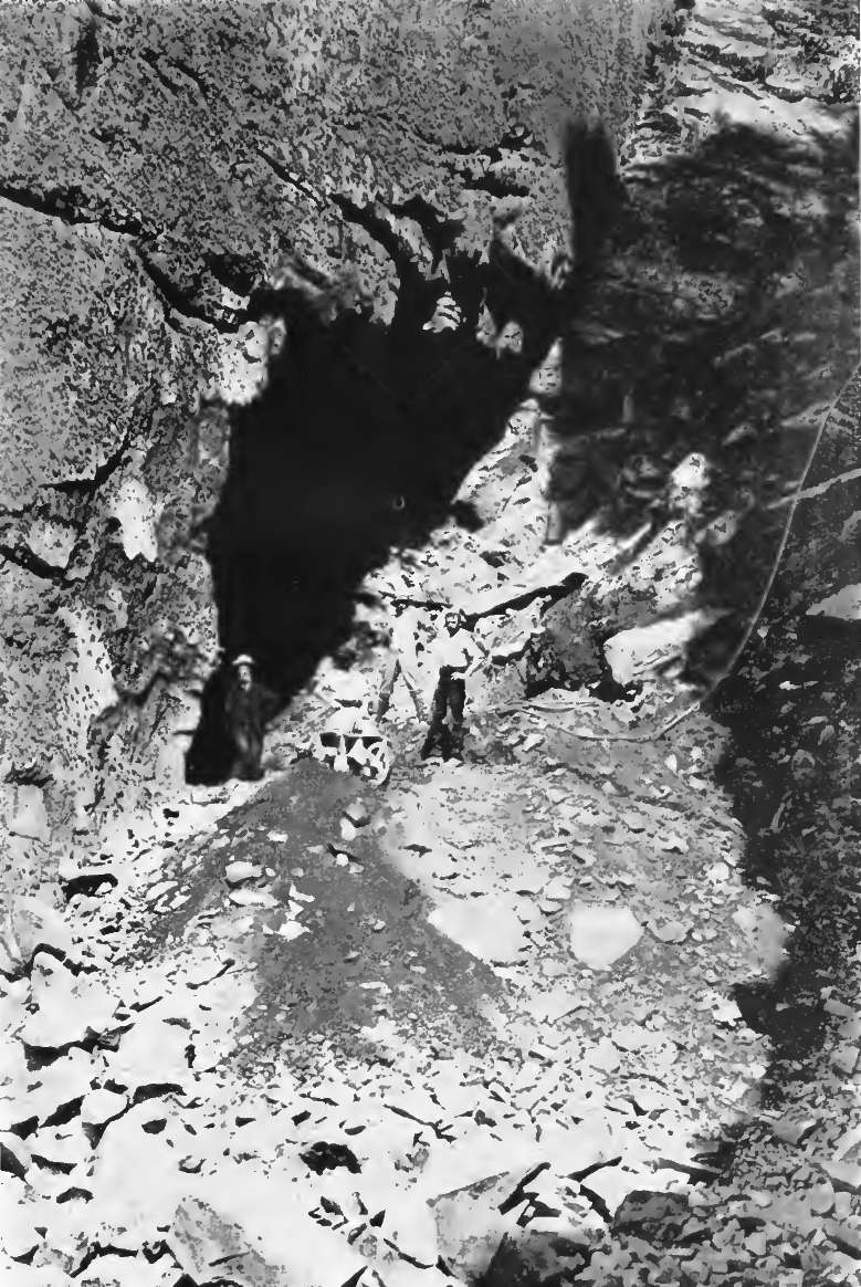
Early Photographs
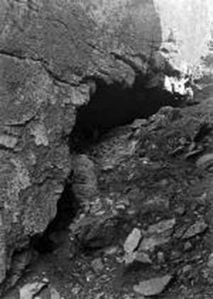
This shows the level of deposits under the arch in 1905.
Photo: Unknown
Source: Courtesy Dr Matt Pope
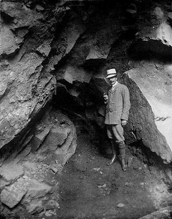
E.T. Nicolle in 1910 at La Cotte.
La Cotte was partially excavated by the Société Jersiaise in 1910 and 1911, under the direction of E.T. Nicolle and J. Sinel.
Photo: Unknown
Source: Courtesy Dr Matt Pope
Early excavations at La Cotte.
This appears to be the South Ravine.
Photo: Unknown
Source: http://www.theislandwiki.org/index.php/File:LaCotte6.jpg
La Cotte in 1936.
Photo: Unknown
Source: Courtesy Dr Matt Pope
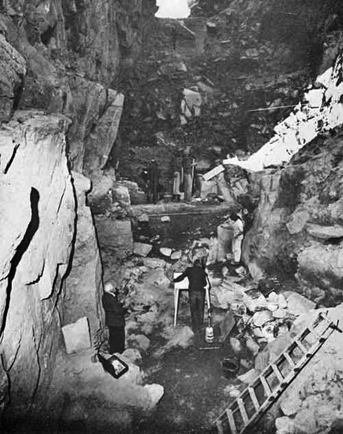
The McBurney Campaign in 1978
These are valuable high quality photographs from the McBurney excavations
Archaeology - La Cotte de St Brelade, 1978.
A view of the main section through the palaeolithic levels at this site in Jersey, where excavations we led by Professor McBurney. Bits and pieces lying around included needles for picking soil fragments off bones, and hardening fluid to drop onto the bone as each piece was exposed. I spent a few days on a mammoth tooth, but didn't get any pics of it.
Photo and text: © Rob McRorie
Archaeology - La Cotte de St Brelade, 1978.
A view of the site from above. In the Palaeolithic period, this was the bottom of a cliff on a wide plain, and animals were probably driven off the cliff edge and butchered in the caves below. At the time of the excavations, it was something of a scramble to get down the path on the right of this image, and to the left, just out of shot, was the sea, which would make some attempts to dampen us at high tide.
Photo and text: © Rob McRorie
Archaeology - La Cotte de St Brelade, 1978.
Lunchtime for the diggers on a sunny day with the tide out. The tide did rise an awful lot, rather a lot of spray would come up this narrow entrance, the archaeological deposits were just behind. My staple digging diet was a large tub of peanut butter from a health shop with good big lumps of the nuts and slowly separating oil, lumps of wholemeal bread and jars of raspberry jam. Liquids sufficed in the evenings.
Photo and text: © Rob McRorie
Archaeology - La Cotte de St Brelade, 1978.
View from the mouth of the cave. Just after the last Ice Age this was a large plain, on which mammoths and other large wildlife roamed. Cliffs from a previous age ran around in a long semicircle, and it is likely that animals were rounded over the cliff edge, being butchered in the cave below. Certainly no shortage of stone tools and bones on site - I spent a happy week on a mammoth tooth, they were very fragile and needed to be dug with a needle and hardened as you went along.
Photo and text: © Rob McRorie
References
- Bates M., 2011: The role of archaeologists in understanding and preventing the impacts of marine industries on the prehistoric environment, UNESCO Scientific Colloquium on Factors Impacting the Underwater Cultural Heritage, Royal Library of Belgium, Brussels, Belgium. 13th & 14th December, 2011.
- Bates M., Pope M., Shaw A., Scott B., Schwenninger J., 2013: Late Neanderthal occupation in North-West Europe: rediscovery, investigation and dating of a last glacial sediment sequence at the site of La Cotte de Saint Brelade, Jersey Journal of Quaternary Science, (2013) 28(7) 647–652 ISSN 0267-8179. DOI: 10.1002/jqs.2669
- Burdo R., 1953: Archaeological Report for 1953, Bulletin of the Societe Jersiaise, 1954, Vol. XVI. Part li, pages II9-125.
- Burdo R., 1956: Résultats des fouilles récentes (1951-1956) à la grotte de la Cotte de Saint-Brelade à Jersey. In: Bulletin de la Société préhistorique de France, 1956, tome 53, N. 7-8. pp. 374-380.
- Callow P., 1986a: The stratigraphic sequence: description and problems, in P. Callow & J.M. Cornford (ed.) La Cotte de St Brelade 1961–1978. Excavations by C.B.M. McBurney, 55–73. Norwich: Geo.
- Callow P., 1988: Across the generations: a long term computing project, Computer and Quantitative Methods in Archaeology, 1988 - BAR
- Callow P. and Cornford J., 1986: La Cotte de St Brelade 1961–1978. Excavations by C.B.M. McBurney., Norwich: Geo.
- Finch O., 2008: Mammoth Hunters exhibition, Catalogue for the Jersey Museum's 2008/2009 Mammoth Hunters Exhibition.
- Hublin J., Richards M., 2009: The Evolution of Hominin Diets: Integrating Approaches to the Study of Palaeolithic Subsistence , Springer, 15 May 2009 - Medical - 284 pages
- Martinson D. et al., 1987: Age dating and the orbital theory of the ice ages: Development of a high-resolution 0 to 300,000-year chronostratigraphy, Quaternary Research, Volume 27, Issue 1, January 1987, Pages 1–29
- Scott B., Bates M., Bates R., Conneller C., Pope M., Shaw A., Smith G., 2014: A new view from La Cotte de St Brelade, Jersey, Antiquity, Vol 88:339, 2014 pp 13-29
- Scott K., 1980: Two hunting episodes of Middle Palaeolithic age at La Cotte de Saint Brelade, Jersey, World Archaeology, 12: 137–52.
- Scott K., 1986b: The bone assemblages from layers 3 and 6, in P. Callow & J.M. Cornford (ed.) La Cotte de St Brelade 1961–1978. Excavations by C.B.M. McBurney, 159–85. Norwich: Geo.
- Sinel J., 1914: Prehistoric Times & Men of the Channel Islands, J.T. Bigwood, States Printer, Jersey, 1914.
- Shackleton N., 2000: The 100 000-year Ice-Age cycle identified and found to lag temperature, carbon dioxide and orbital eccentricity, Science, 289, 1897 – 1902.
- Smith G., 2010: Assessing evidence for human megafaunal hunting at Lynford (UK)The World of Mammoths: Vth International Conference on Mammoths and their relatives, Le Puy-en-Velay 30th August - 4th September 2010, file: mammoth-human-interactions_aug2010.ppt