Back to Don's Maps
 Back to Archaeological Sites
Molí del Salt - first depiction of Palaeolithic dwellings

The Molí del Salt campsite
Photo: Digital reconstruction of the Molí del Salt campsite, by Luis Alberto Marcos.
Hut design from Apache Wickiup, Edward Curtis, 1903 by Library of Congress.
Licensed under public domain via Wikimedia Commons. doi:10.1371/journal.pone.0143002.g007
Source: García-Diez and Vaquero (2015)
An engraved object recently found at the site of Molí del Salt in Spain and dated to the end of the Upper Paleolithic, about 13 800 BP, may show a hunter-gatherer campsite. The site location is privileged so far as mobility and resource distribution are concerned. On the one hand, the Francolí valley is a natural passage linking the Ebro basin and the coastal Mediterranean regions. On the other hand, it is an ecotone between the plain of the Ebro basin and the mountain domain of the Prades Mountains, 4 km south of the site. In addition, good-quality flint outcrops are common in the region.
Site description, chronology and archeological context:
The Molí del Salt site is located in the village of Vimbodí i Poblet, 50 km west of the city of Barcelona (Northeastern Iberia), at 490 m above sea level on the left bank of the Milans, a small tributary of the Francolí river. Its UTM coordinates are X=336532.5 Y=458446.5 (ETRS89 system). (This is 41.395055N, 1.044661E as a lat/long - Don ) It is a south-facing rockshelter in the Tertiary conglomerates of Upper Oligocene age that are common along the eastern borders of the Ebro basin.
The site location is privileged as far as mobility and resource distribution are concerned. On the one hand, the Francolí valley is a natural passage linking the Ebro basin and the coastal Mediterranean regions. On the other hand, it is an ecotone between the plain of the Ebro basin and the mountain domain of the Prades Mountains, 4 km south of the site. In addition, good-quality flint outcrops are common in the region.
Although the Molí del Salt was reported as an archeological site in the 1950s, the first excavations were carried out in 1999 and consisted of a test pit of 3 m2 that allowed documenting of the whole stratigraphic sequence. When the excavations started, the rockshelter was entirely filled by sediments, and most of the roof was collapsed. After the positive results yielded by the exploratory works, a research project was undertaken in 2001 and is still in progress under the direction of one of us (M.V.). The excavated area has been extended from the first excavations up to 70 m2 of the current excavation area.
Text above: García-Diez and Vaquero (2015)
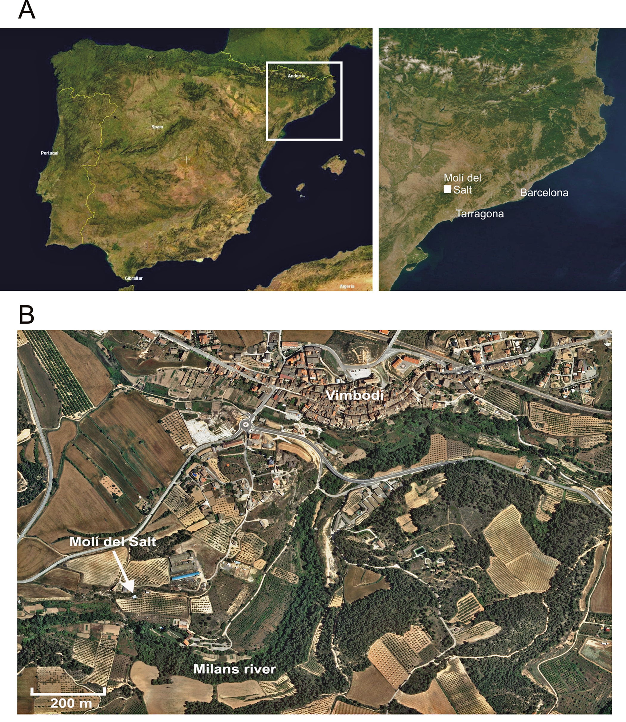
Location of Molí del Salt in Northeastern Iberian Peninsula. A. NASA Satellite pictures. Licensed under Public Domain via Wikimedia Commons. B. Cartographic base (orthophoto) from the Institut Cartogràfic i Geològic de Catalunya (www.icgc.cat).
The Late Upper Paleolithic units have been dated between ca. 13 000 and 15 000 cal BP. Both the faunal and lithic assemblages exhibit the characteristics typical of the Late Upper Paleolithic sites in Mediterranean Iberia. Rabbit is the most represented species at every archeological level, although some macromammal remains (ibex, red deer, wild boar, lynx, fox, and badger) have also been documented. Flint is the dominant raw material in lithic assemblages and the toolkits are composed of the artifacts commonly found in Late Magdalenian sites: endscrapers, backed artifacts, truncations, denticulates, burins, and borers.
Photo and text: García-Diez and Vaquero (2015)

A. Image of the site from the opposite side of the Milans River.
B. General view of the area that is currently being excavated.
Thirteen portable art objects with engravings have so far been recovered. Nine of them are schist slabs, but representations have also been identified on three limestone cobbles and one bone fragment. Most of these objects were found in unit A and show animal figures and schematic motifs with the typical late-Paleolithic stylistic patterns. The art object presented in this paper is an engraved schist slab found at the top of unit B (level B1) during the 2013 field season. A bone fragment located 82 cm from the engraved slab in the same stratigraphical horizon has been dated to 11 880±50 BP (14 062–13 498 cal BP at 95.4% probability)
Photo and text: García-Diez and Vaquero (2015)
(Schist is a medium to coarse-grained, foliated, metamorphic rock typically containing muscovite, biotite, chlorite, quartz and feldspar. It is normally a very hard rock, but with distinct layers along which it will split when subjected to a great deal of force, creating a relatively flat surface. When available, it is an ideal medium for engravings, since it often occurs in large slabs, and any marks made will be immediately very apparent on the surface. These engravings will be very resistant indeed to water, acids, alkalis, and accidental erasure. - Don )
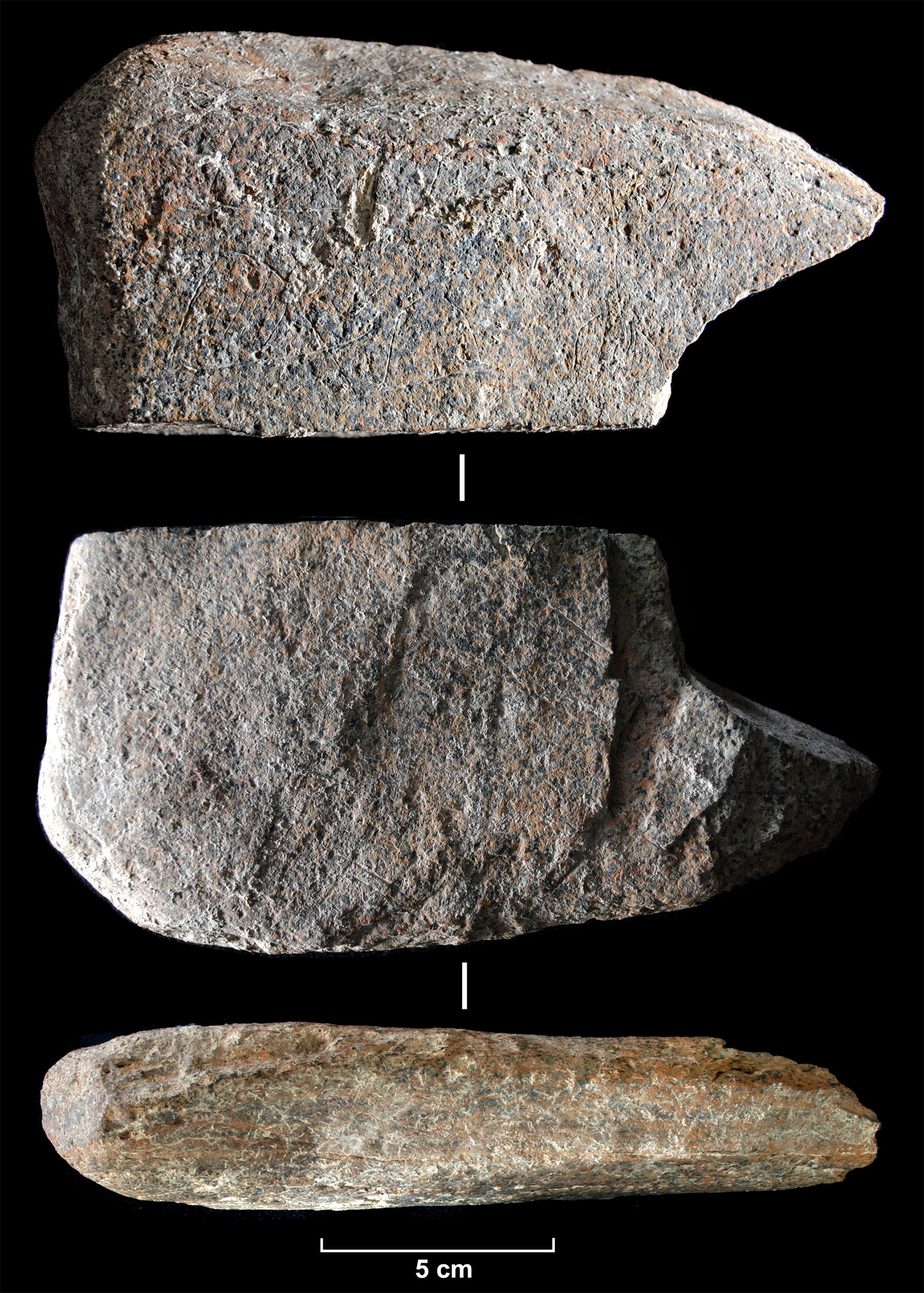
Photograph of the engraved schist slab from Molí del Salt.
The engraved slab (ref. num. MS13 B1 E35/22) is housed in the Institut de Paleoecologia Humana i Evolució Social (IPHES), Marcel·lí Domingo s/n, Campus Sescelades URV, 43007 Tarragona, Spain.
The slab shows a trapezoidal morphology, and its maximum dimensions are 18 cm wide, 8.5 cm high, and 3.6 cm thick (Figs 3, 4 and 5). Grauvaquic schist is from the Paleozoic formations 4 km south of the site and schist slabs are abundant in the alluvial deposits in front of the rockshelter. There are seven graphic units in the upper surface, while only a small set of lines are recognized in the lower one. The graphic units correspond to seven semicircular motifs whose interior was filled by straight parallel lines.
Photo and text: García-Diez and Vaquero (2015)

Drawing of the engraved schist slab.
The geometric structures are constructed from two different contour lines–one straight and one curved–that define the convex character. The straight line defines the lower part of the motif, so all structures have the same disposition. The interconnection between the two structural lines is blurred, as neither contour line touches or exceeds the other (normally, the bottom line exceeds the ends of the curved line). The number of internal lines varies between 7 and 11 (Table 1), mostly covering the entire interior space.
The internal lines, in general, do not reach the contour lines, and they show a horizontal (two cases) or oblique (five cases, three of which show a marked tendency to vertical) disposition. The size of the graphic units varies between 43 and 20 mm in width and between 22 and 14 mm in height. If we consider only the semicircular shape, without considering the appendices of the lower contour line, the dimensions range between 30 and 18 mm in width and 22 and 14 mm in height.
Photo: García-Diez and Vaquero (2015)
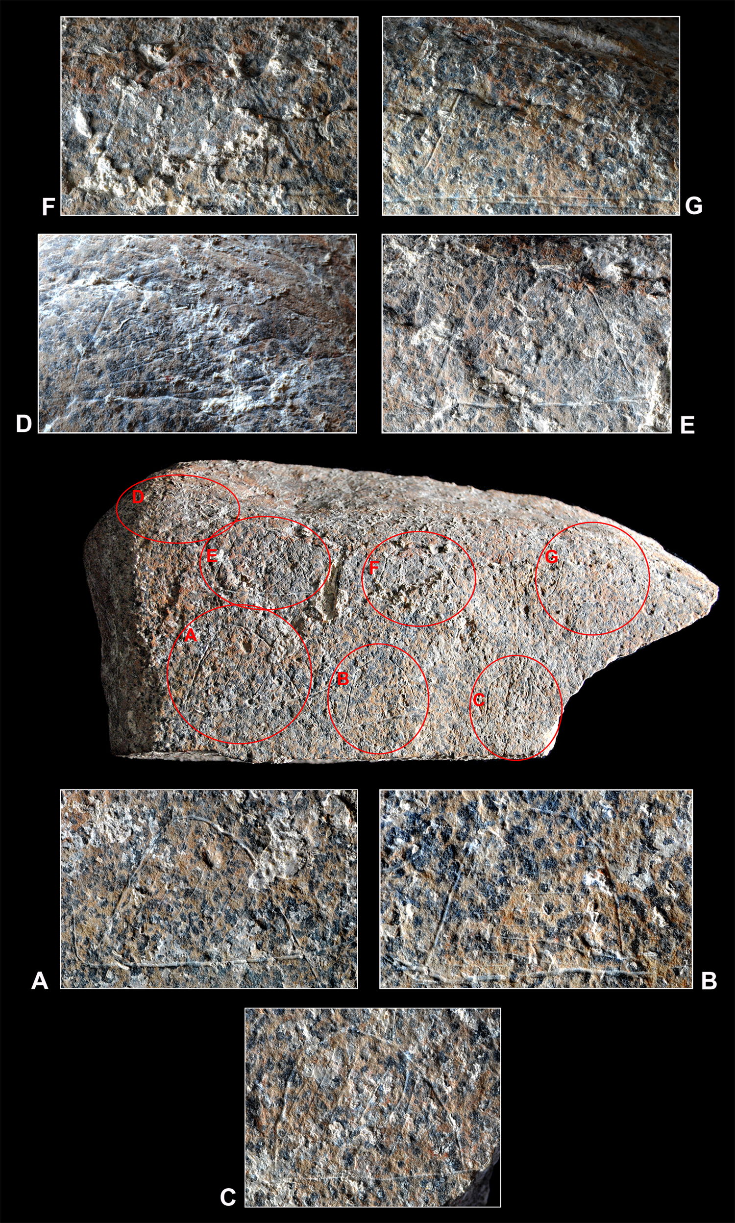
Closeups of the engravings on the schist slab. (Note in particular the shadings within the outlines to give depth to the drawing - Don )
We hypothesize that the seven semicircular motifs in the MS engraving represent dwellings or huts. In addition, the close formal, metric, and technical linkages among these motifs, as well as their distribution in the graphic field, indicate their compositional association and their execution in a short time. To support the interpretation of the MS engraving as a campsite, we will focus on three aspects for which we have ethnographic information: the outline of the huts, their proportions, and the number of huts in a campsite.
The use of ethnographic information in archeological interpretation has been common since the 1970s. This is based on the assumption that there are some analogies between present and past societies that produce similar archeological outcomes. Hunter-gatherer architecture is strongly conditioned by one of the characteristics associated to most hunter-gatherer societies: residential mobility. According to this assumption, mobile hunter-gatherers will show common traits in their architectural patterns, regardless their historical contexts.
Photo and text: García-Diez and Vaquero (2015)
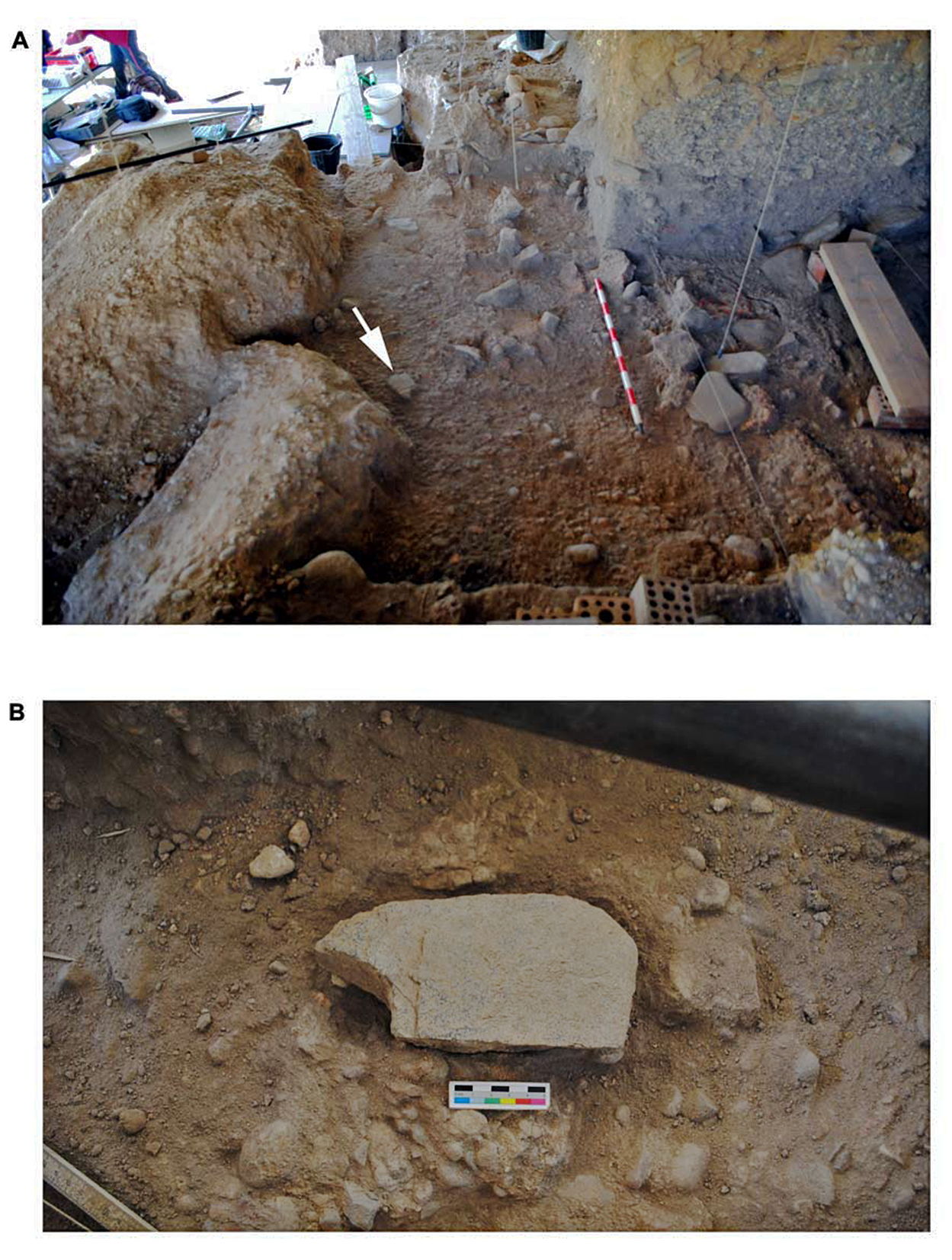
Photograph of the engraved schist slab from Molí del Salt in situ, on the excavation surface corresponding to the upper part of level B1. The arrow on the upper photo points to the location of the schist plaque.
Photo and text: García-Diez and Vaquero (2015)
The construction of the huts
Regarding the morphology, ethnographic data indicate that mobile peoples tend to build domed circular or semicircular houses. These huts are normally made using a frame of wooden poles covered with some sort of roofing material (grass, brush, hides). Dome-shaped dwellings–also known as beehive huts and wigwam or wickiup–are more common among hunter-gatherers than the conical tepees sometimes used as a reference for the reconstruction of Paleolithic dwellings. Domes are self-supporting structures and do not need inner supportive elements, providing an entirely free interior space. They are more stable and resistant to physical forces and enclose the largest volume with the smallest structure. Although they are difficult to subdivide into compartments and cannot be enlarged without removing structural elements, these drawbacks seem of little concern for highly mobile people.Text above: García-Diez and Vaquero (2015)
The construction of circular dome-shaped structures may be completed in a short time and they are therefore particularly appropriate in short-term camps. Sometimes, the use of dome-shaped dwellings exhibits a seasonal pattern; they are preferred in the most mobile phase of the settlement system, while other lodges are built in the most sedentary phase. As societies become sedentary and their sociopolitical organization becomes more complex, rectilinear houses tend to be more common. It should be stressed that some societies that have adopted rectilinear lodges still maintain dome-shaped structures for the building of particularly ephemeral huts, such as sweatlodges and menstrual huts. It seems, therefore, that temporary dome-shaped dwellings are closely linked to the mobility and social structure typical of hunter-gatherers.
Dousset (2011) notes how the Ngaatjatjarra quickly abandoned the Western-style rectangular houses provided by the Australian administration and returned to the dome-shaped traditional wiltjas, even recycling the construction materials from the rectilinear lodges. According to Dousset, such allegiance to the traditional dwellings is related to the preservation of the social relations characteristic of the hunter-gatherer life-ways.
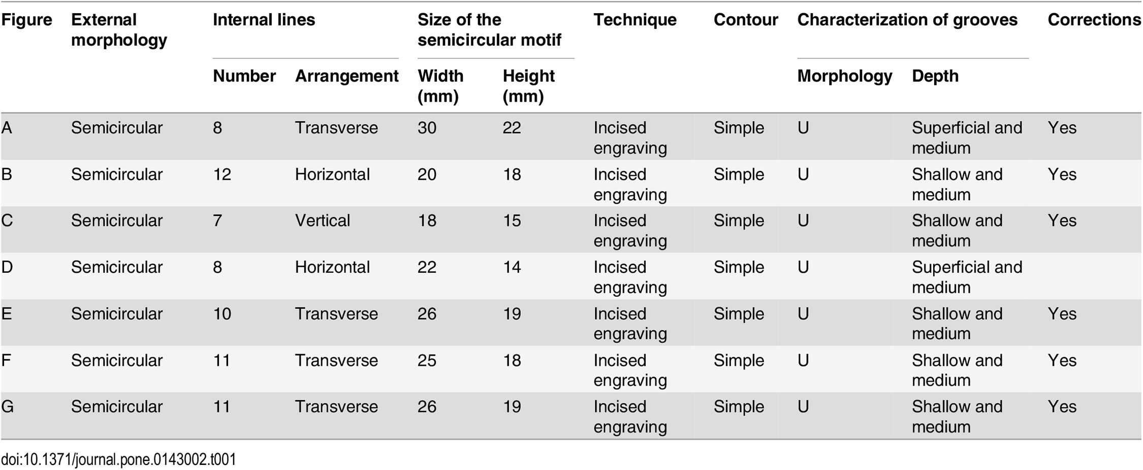
Morphological, metric and technical attributes of the seven semicircular motifs identified in the Molí del Salt slab.
Photo and text: García-Diez and Vaquero (2015)
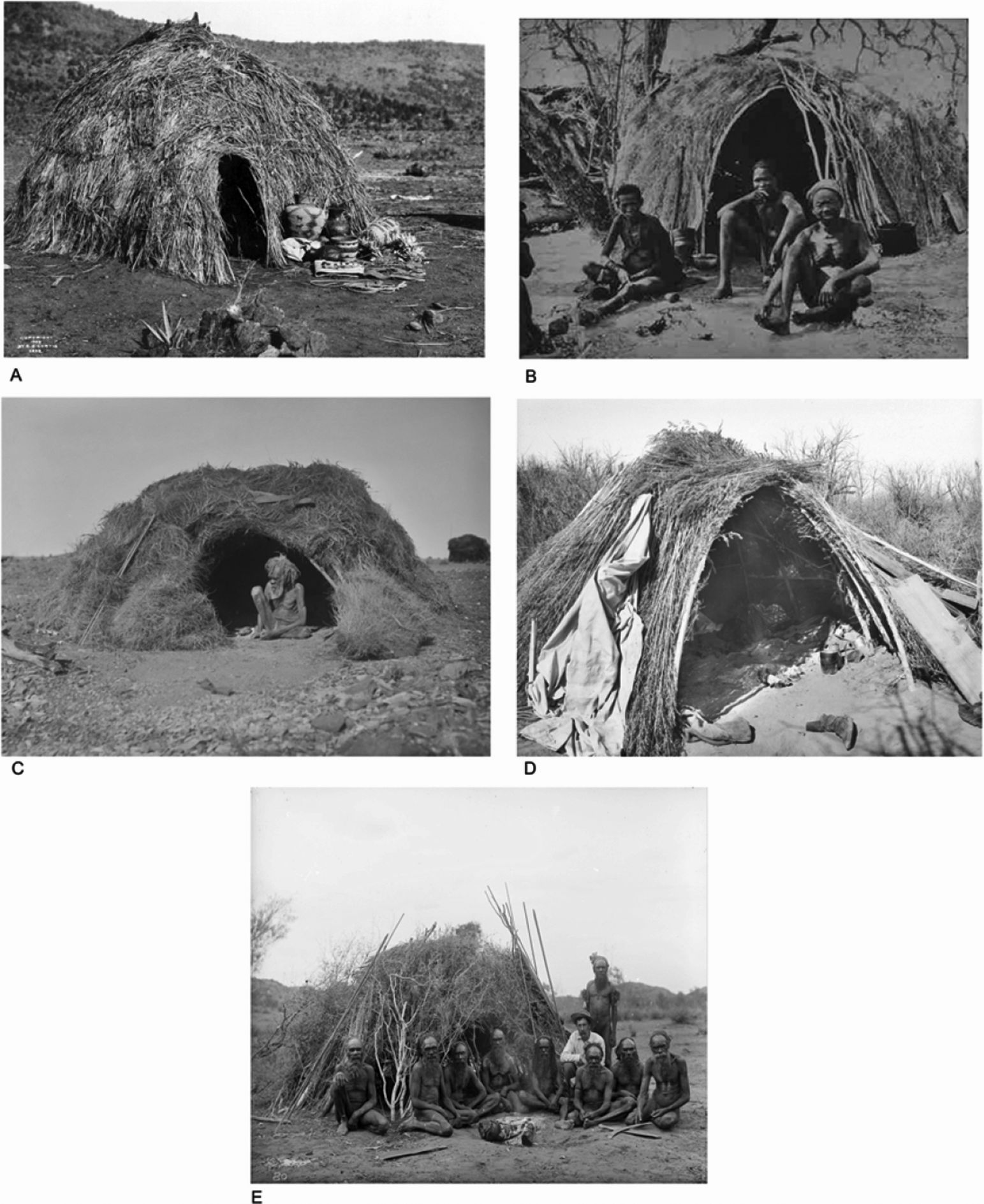
Ethnographic examples of dome-shaped dwellings in hunter gatherer campsites.
A. Apache Wickiup, Edward Curtis, 1903 by Library of Congress. Licensed under Public domain via Wikimedia Commons.
B. Bushmen San. Licensed under Public domain via Wikimedia Commons.
C. Hut Eastern Arrernte by Herbert Basedow - National Museum of Australia. Licensed under Public domain via Wikimedia Commons.
D. Apache Indian Kan or brush house, ca.1900 (CHS-3581) by Pierce, C.C. (Charles C.). Licensed under Public domain via Wikimedia Commons.
E. Baldwin Spencer seated with the Arrernte elders, Alice Springs, Central Australia, 1896. - Google Art Project by Walter Baldwin Spencer and Francis J Gillen.
Photo and text: García-Diez and Vaquero (2015)
Number of huts
Band size displays a high degree of variability, both at the intra-group and inter-group levels. Dynamics of fission and fusion related to the seasonal variability in resource distribution characterize most hunter-gatherer bands. In addition, there are other factors related to the primarily exploited resources. Band sizes of mobile peoples depending on terrestrial plants are smaller (12 ± 4 during the most dispersed phase of the settlement system and 34.1 ± 10.8 during the most aggregated) than those of mobile peoples primarily dependent upon hunting of terrestrial animals (16.3 ± 5.1 during the most dispersed phase and 46.7 ± 18.2 during the most aggregated phase).Text above: García-Diez and Vaquero (2015)
The number of dwelling structures in a hunter-gatherer camp is also highly variable. This number depends not only on the band size or the amount of familiar units forming the band but also on the socio-economical organization. When taking into account the different hunter-gatherer systems distinguished by Binford, the groups characterized as 'generic hunter-gatherers' show 2.6 ± 1.1 households per camp during the most dispersed phase of the settlement system and 7.6 ± 3.9 during the most aggregated phase. The seven huts in the MS engraving fit perfectly with this mean number of households in aggregation camps and are close to the mean values of other hunter-gatherer systems.
The setting in the landscape
The archaeological context of the site reinforces this interpretation of the MS engraving. In front of the rockshelter, there is a plain descending smoothly to the river, which is located 100 m south of the site. This setting has been documented for some open-air Magdalenian sites interpreted as campsites and is characterized by well-defined clusters of remains corresponding to domestic areas.Text above: García-Diez and Vaquero (2015)
In the plain in front of the MS rockshelter, surface archeological remains are abundant and thousands of artifacts have been recovered over the years. Most of them exhibit a fresh appearance, indicating that they were not displaced from the rockshelter but correspond to in situ archeological deposits below the current surface. Moreover, they exhibit the same technological and typological characteristics as the lithic assemblages from the rockshelter. This suggests that alongside the rockshelter, there was also an open-air settlement in the plain next to the river. It seems likely, therefore, that the engraving represents a reality that was in front of the artist’s eyes at the moment of the depiction.
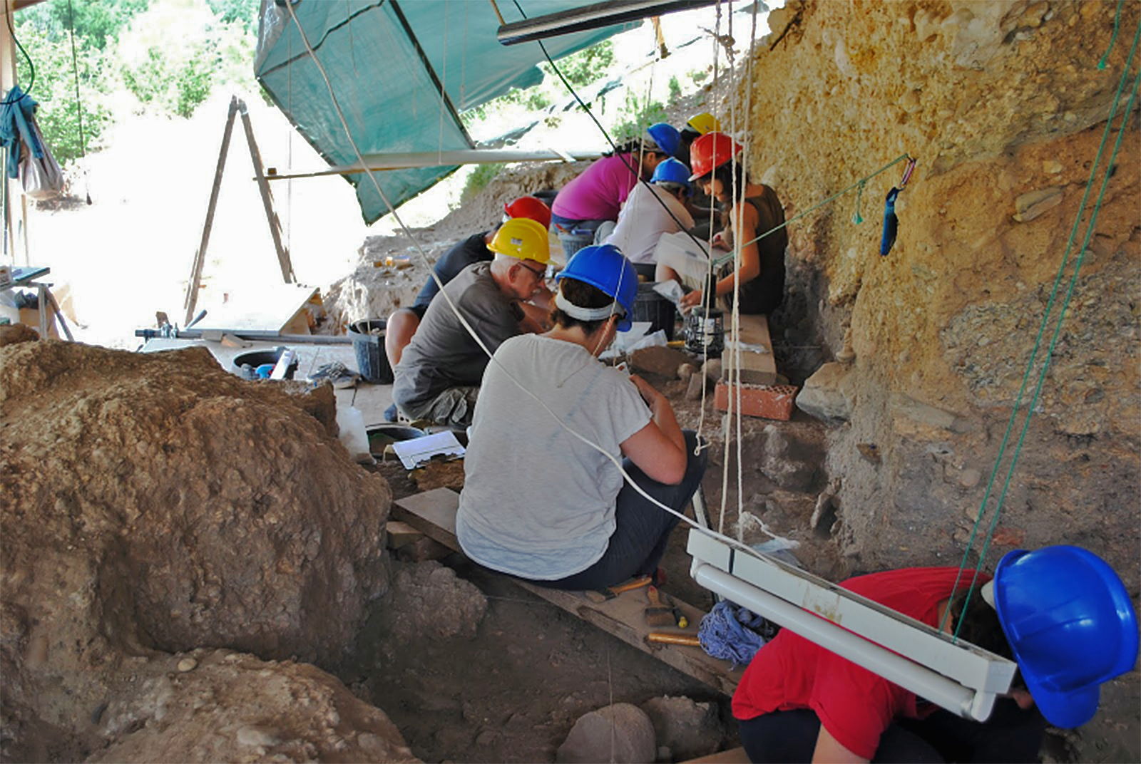
Excavation in progress at Molí del Salt.
Photo: Fundació Instititut Català de Paleoecologia Humana i Evolució Social (IPHES)
Source: http://intranet.ceics.eu/ca/web/ceics/heritage-and-culture/news-detail/-/journal_content/56_INSTANCE_G3hE/11217/100868
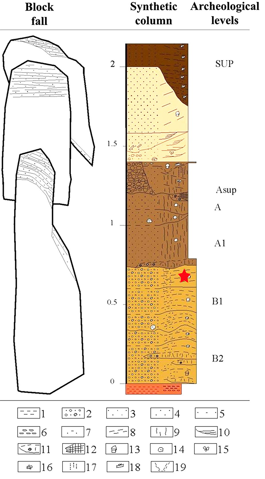
Stratigraphic sequence of Molí del Salt.
Lithology:
1. Clay
2. Gravel
3. Silt
4. Sandstone
5. Sand-Clay
Sedimentary structure:
6. Nodular
7. Graded
8. Plane not paralleled
9. Massive
10. Channel
11.
Lenticular massive
12. Hearth
Edaphic traits:
13. Polyhedron
14. Microaggregates
15. Particular
16. Crumbly rock
17. Pseudomycelia
18. Calcitic pendants
The red star
indicates the stratigraphic location of the engraved slab.
(Note that block fall appears to have occurred several times, leading to the bases of the blocks being staggered at different levels. It would also appear that the major blocks have been shown side by side for convenience in this diagram, instead of separated in space as would in fact have occurred - Don )
Photo and text: Vallverdú and Carrancho (2004)

14C AMS dates from Molí del Salt.
14C ages have been converted to
calendar ages using the CalPal2007-HULU Calibration Curve in the CalPal
calibration software.
Photo and text: García-Diez and Vaquero (2015)
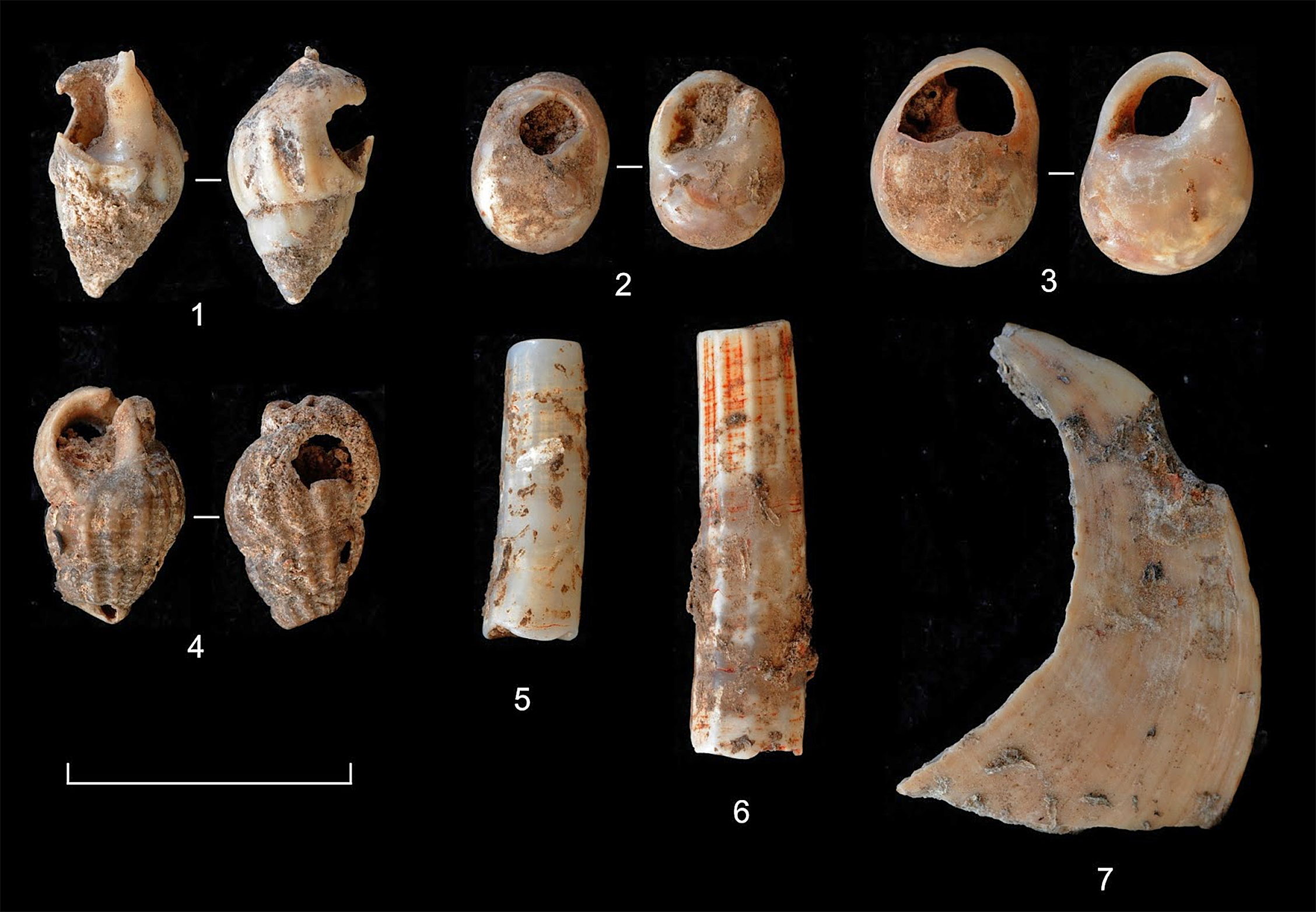
Jewellery from Molí del Salt.
Photo: Fundació Instititut Català de Paleoecologia Humana i Evolució Social (IPHES)
Source: http://iphes-noticies.blogspot.com.au/2015/07/descobreixen-mes-de-5000-noves-restes.html
Tools
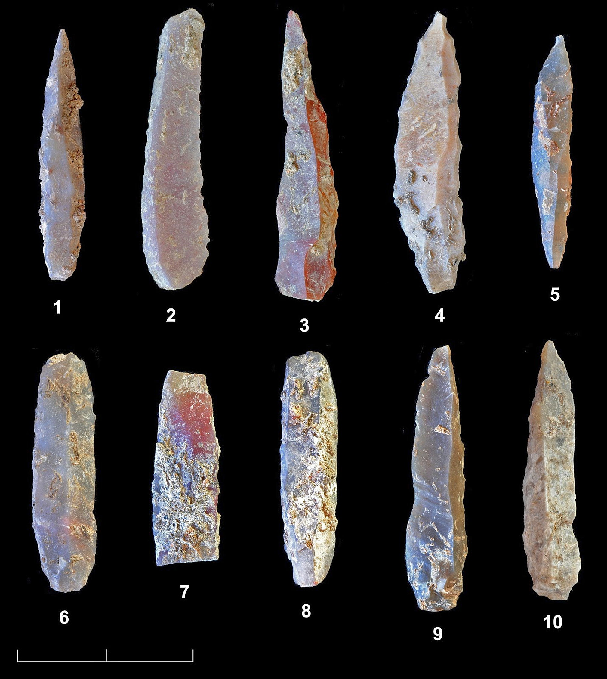
A small sample of the tools that have been discovered during the 2015 campaign.
The lithic industry is made on flint and very well preserved. A broad range of tools used in domestic activities – hide-working, butchering and carcass processing, bone artefact manufacture, etc – has been recovered. Many lithic points used as hunting weapons have also been found.
The mobile art pieces from this season, together with the fourteen found in previous years, are particularly noteworthy and make Molí del Salt the most important collection of Palaeolithic art so far documented in Catalonia.
Photo: Fundació Instititut Català de Paleoecologia Humana i Evolució Social (IPHES)
Source and text: http://iphes-noticies.blogspot.com.au/2015/07/descobreixen-mes-de-5000-noves-restes.html

Lithic tools from the late Magdalenian assemblages of Molí del Salt.
Endscrapers: 1, 2, 6-8, 10 and 11.
Backed elements: 3-5 and 9.
Truncation: 12.
Photo and text: García-Diez and Vaquero (2015)
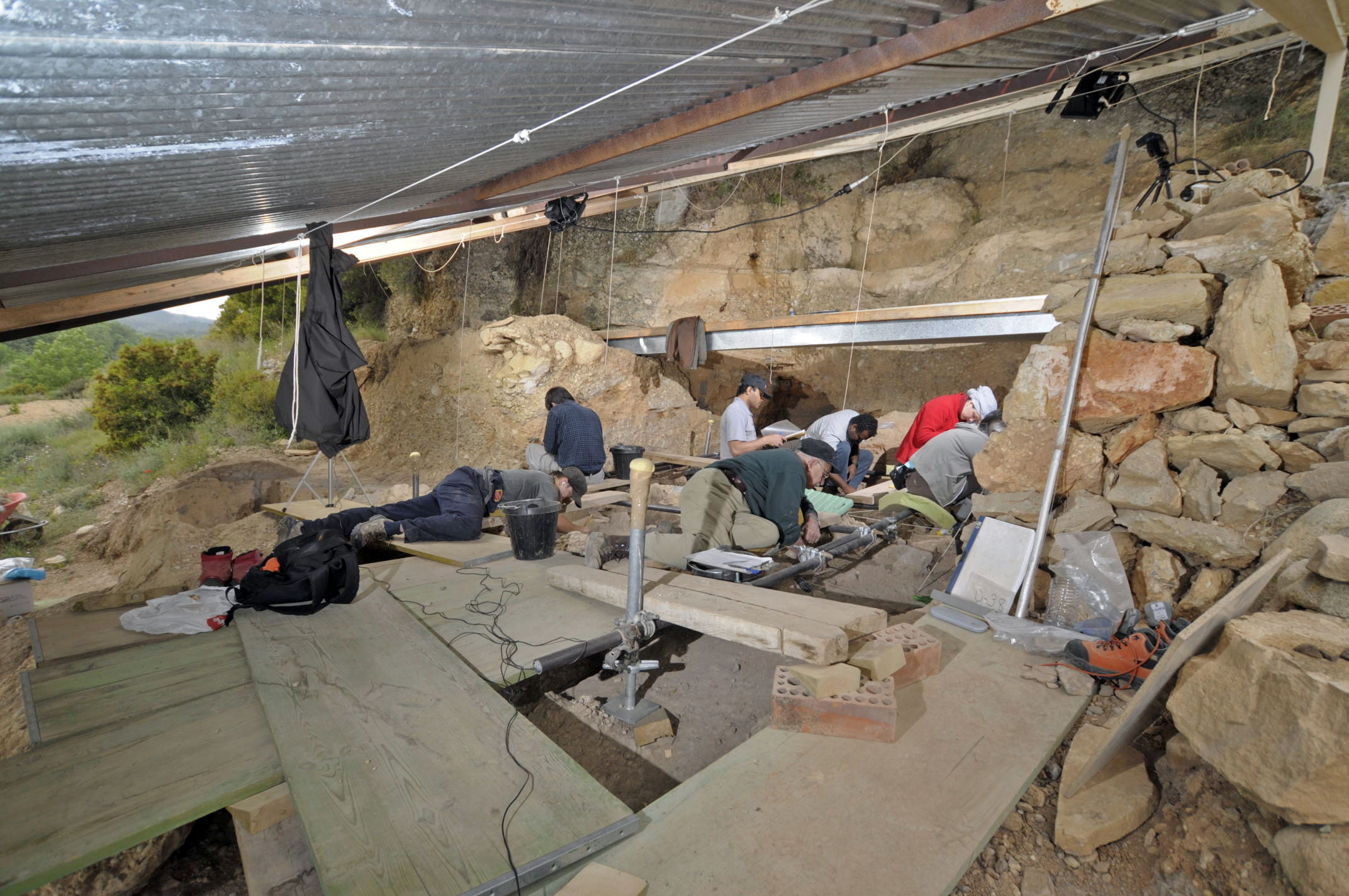
Photo of work in progress at the rock shelter. Boards have been laid across the sediments to allow researchers to reach areas towards the back of the shelter without damaging the lower layers.
Flint is overwhelmingly dominant in the lithic assemblages and it was practically the only raw material used in knapping activities. The technological and typological characteristics are typical of Late Upper Palaeolithic assemblages in Mediterranean Spain. In general, toolkits are dominated by endscrapers, backed elements (points and blades) and denticulates, although other types (burins, borers, abrupts, truncations) are also relatively well represented.
Concerning animal resource exploitation, rabbit is the most represented species. Other documented species are: ibex, red deer, wild boar, lynx, fox and badger. Some remains from birds have also been identified. This faunistic spectrum, and especially the predominance of rabbit, is common in the Upper Palaeolithic record of the Mediterranean coast of the Iberian. Different evidences of bone industry have been also recovered.
In addition, perforated marine shells used as pendants have been found. There have been documented specimens that correspond to different species (Pecten jacobaeus, Glycymeris glycymeris, Cyclope sp., Dentalium sp.).
Photo: Fundació Instititut Català de Paleoecologia Humana i Evolució Social (IPHES)
Source and text: http://www.iphes.cat/mol%C3%AD-del-salt
Heat treatment of tools
Heat treatment improves the knappability of siliceous stones through the removal of interstitial water. This behavior has been noted in ethnographic contexts and has been identified in some Paleolithic assemblages, particularly in the manufacture of tools that require relatively high technical skill. For example, the thermal preparation of flint was used in the manufacture of Solutrean points in Parpalló Cave (Tiffagom, 2006)).Text above: Vaquero et al. (2012)
However, determining the intentional nature of this heat treatment is not always straightforward and the accidental burning of lithics cannot be ruled out in some cases. In addition, thermal treatment seems superfluous for the manufacture of most Upper Paleolithic tools, which do not require high technical skill and are commonly made on unburned blanks. In this context, the typological distribution of tools retouched after fire damage can provide insight into the use of an intentional heat treatment. If the most skill-demanding tools show higher indices of post-damage retouch, intentional heat treatment would be supported.
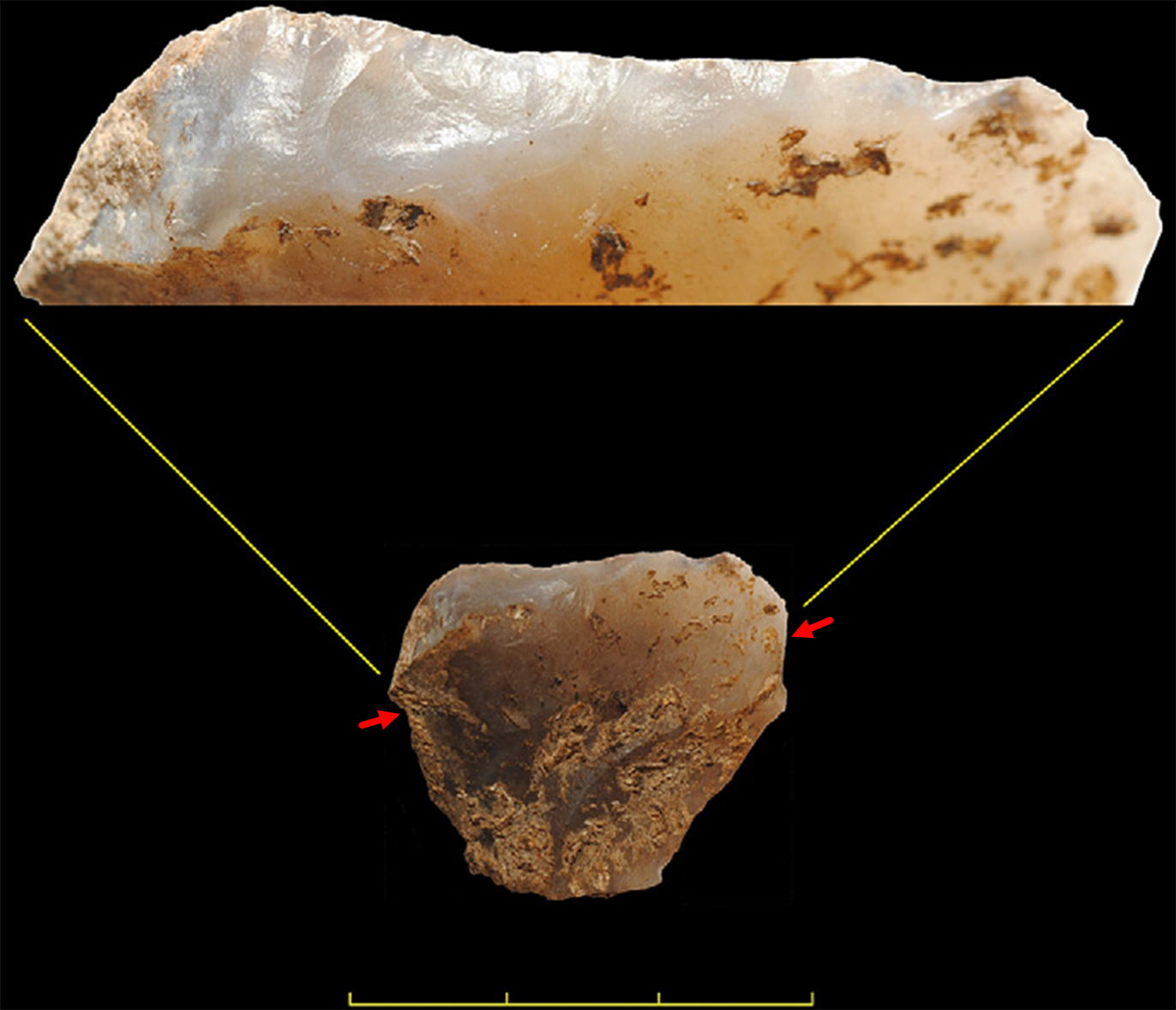
Endscraper from Molí del Salt retouched after fire damage. Close-up of the retouched edge showing the greasy luster characteristic of post-damage retouch.
(This photograph shows the whole tool, and above it a closeup of the retouched edge. I have added the red arrows to accurately indicate the line along which the closeup has been created. It should be noted that the closeup is at a slightly different angle to the photo of the whole tool - Don )
Photo and text: Vaquero et al. (2012)
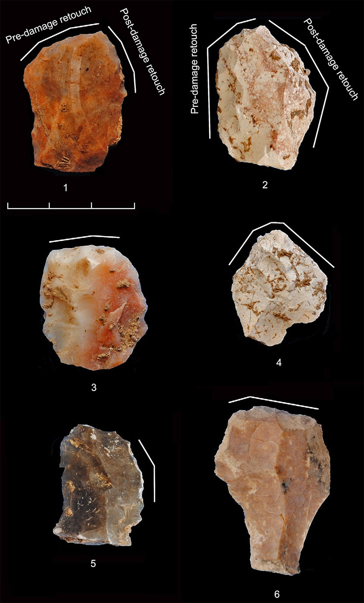
Tools from Molí del Salt retouched after fire damage. White lines indicate the location of the retouched edges.
1, 5. Retouched blanks.
2. Endscraper with lateral retouch.
3, 4, 6. Endscrapers.
1
and 2 were retouched both before and after fire damage.
Photo and text: Vaquero et al. (2012)
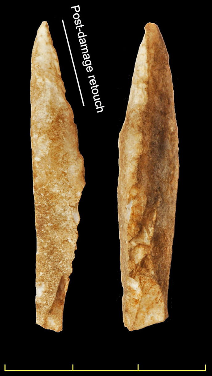
Backed point retouched after fire damage.
Retouch is limited to the distal end
of the point. This expedient procedure for manufacturing backed tools is uncommon at
Molí del Salt.
Photo and text: Vaquero et al. (2012)
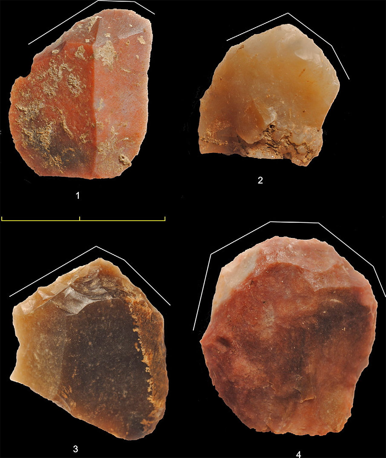
Endscrapers from Molí del Salt retouched after fire damage. White lines indicate the location of the retouched edges.
Photo and text: Vaquero et al. (2012)
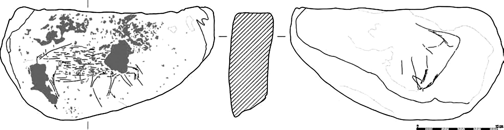
Engraved plates from Molí del Salt
Schist plaque 280 × 195 × 55 mm. The faces are flat and polished and the edges are rounded. Both faces were partially covered by a reddish silty carbonate concretion. It was found in 2001 without stratigraphic context, but the characteristics of the concretions (García-Diez M. et al., 2002) suggest that we can assign it with the others in set B.
Photo and text: García-Diez and Vaquero (2006)

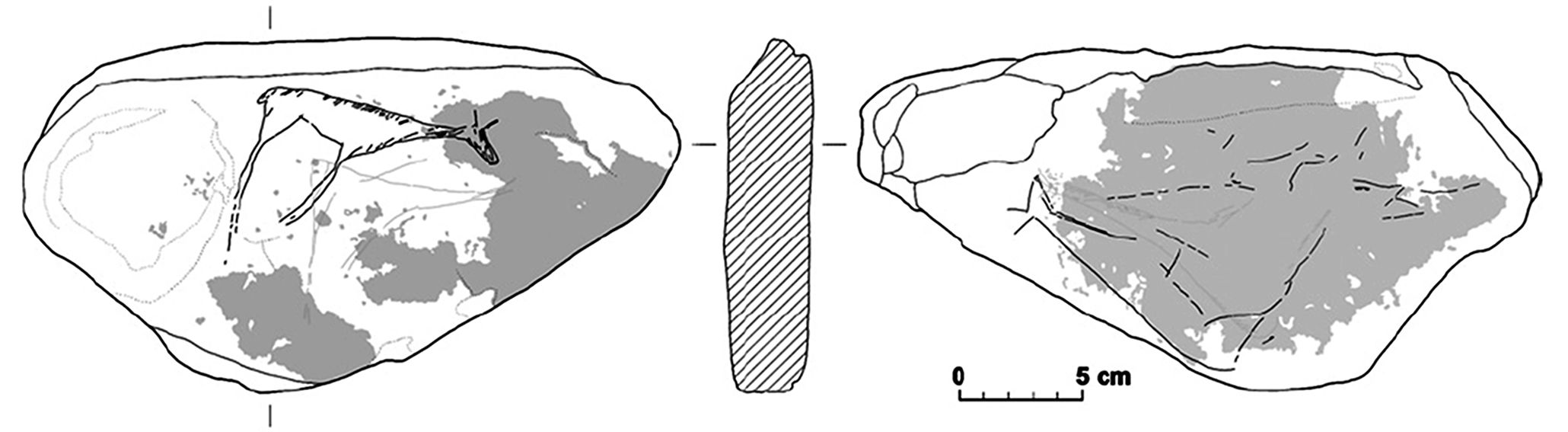
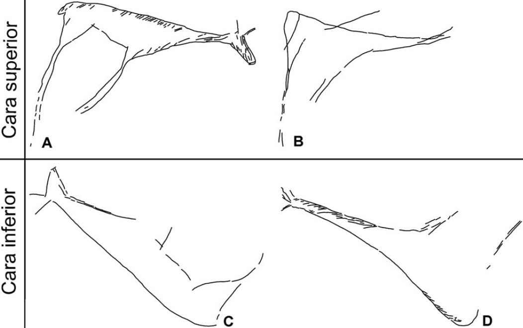
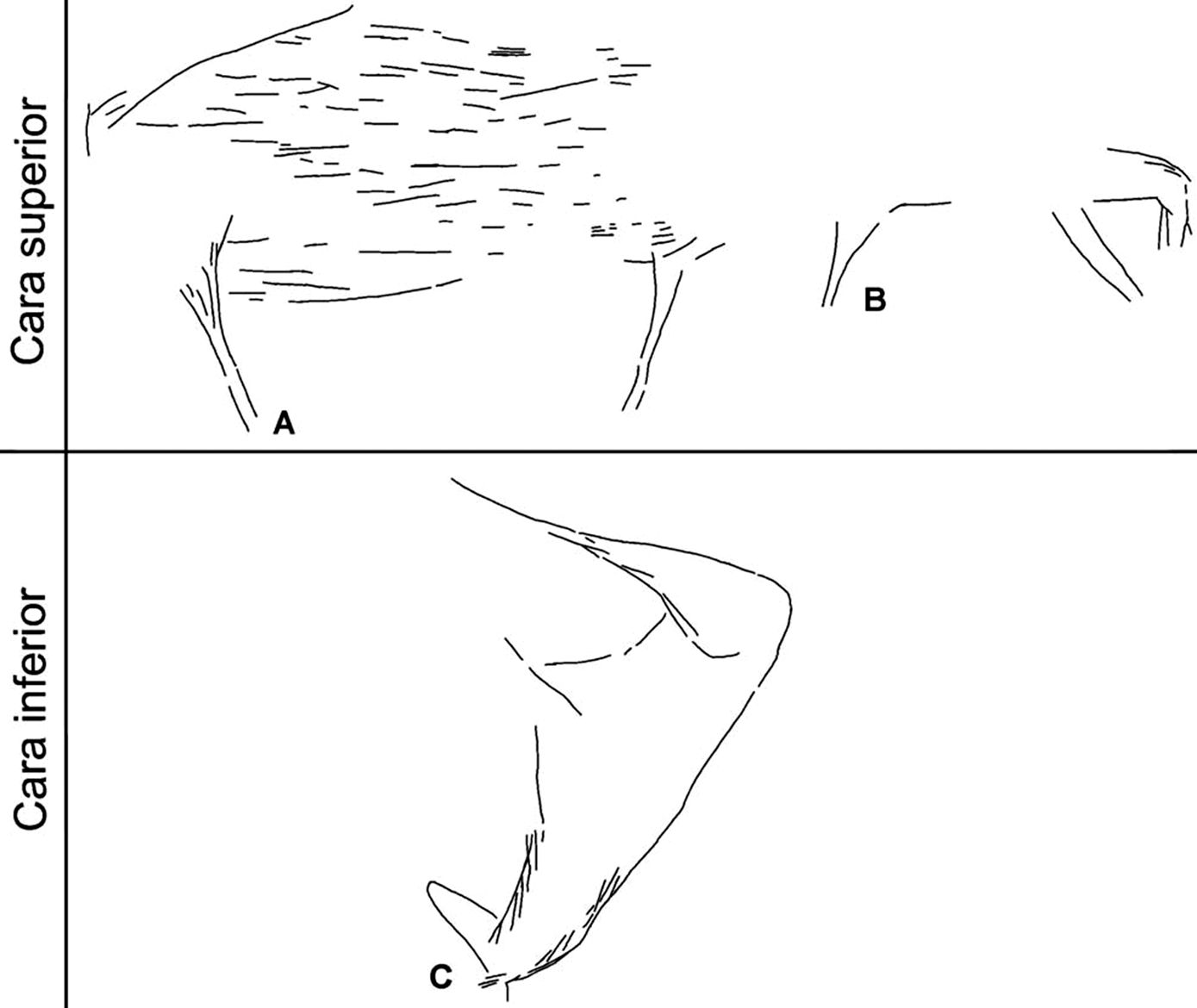
Graphic units from plaque 1.
Upper face: A) human figurine, B) bundle of lines, C) indeterminate animal.
Lower face: D) aurochs, E) indeterminate animal, F) indeterminate animal.
Photo and text: García-Diez and Vaquero (2006)
Three graphic units were engraved on the upper surface.
A: In the central area there is a human figure, 26 mm in width and 72 mm in height, as defined by its vertical stiffness and the body structure, the drawing of the contour, the distinctive shape of the lower end relative to the body by a marked inflection of the belly and the small projection of the lower back at the buttocks.
The figure is composed of a head, back, buttocks, the lower extremities, the abdomen, the chest, the upper extremities and the neck. Two vertical lines are associated with the upper part of the head; we can consider two hypotheses to interpret this clearly non-human feature:
1. The lines represent horns and show an additional animal character.
2. The lines represent a headdress.
A cluster of of parallel trend lines, 108 mm wide and 66 mm high, was engraved at the centre. To the right one can recognise the representation of an unknown animal, 113 mm wide and 115 mm high, with two dorsal lines, two buttocks, a tail, two hind legs, a belly, a front leg and chest. Despite the repetitions of anatomical parts, there is only one line for the abdomen, a foreleg and a chest; this characteristic and the close physical relationship of the lines suggest that the repetition could be the result of adjustments and changes to the animal depiction during the drawing process.
There are three graphics units on the underside. At the lower left the head of an aurochs can be identified, 42 mm wide and 46 mm high, formed by the jaw line, the forehead line and the horn. The interior of the head shows lines parallel to the forehead and jaw.
Occupying a larger area, there is the partial representation of the body of an unknown animal, 164 mm wide and 119 mm high, which is made up of a neck, dorsal line, the buttock, a hind leg and a possible foreleg. We could discuss a relationship between the front of this unit and the head of the aurochs, but this association implies an error in the placement of the anatomical parts. On the lower part of the underside, and the opposite way with respect to the rest of the units, there is the figure of an unknown animal (possibly a deer), 120 mm wide and 18 mm high, formed by the jaw line, the nasofrontal line, the hairline, ears, neck and dorsal line. (This last seems to me a triumph of belief over substance! - Don ) Finally, on both sides were observed lines that do not consist of animal figures, human, linear or geometric.
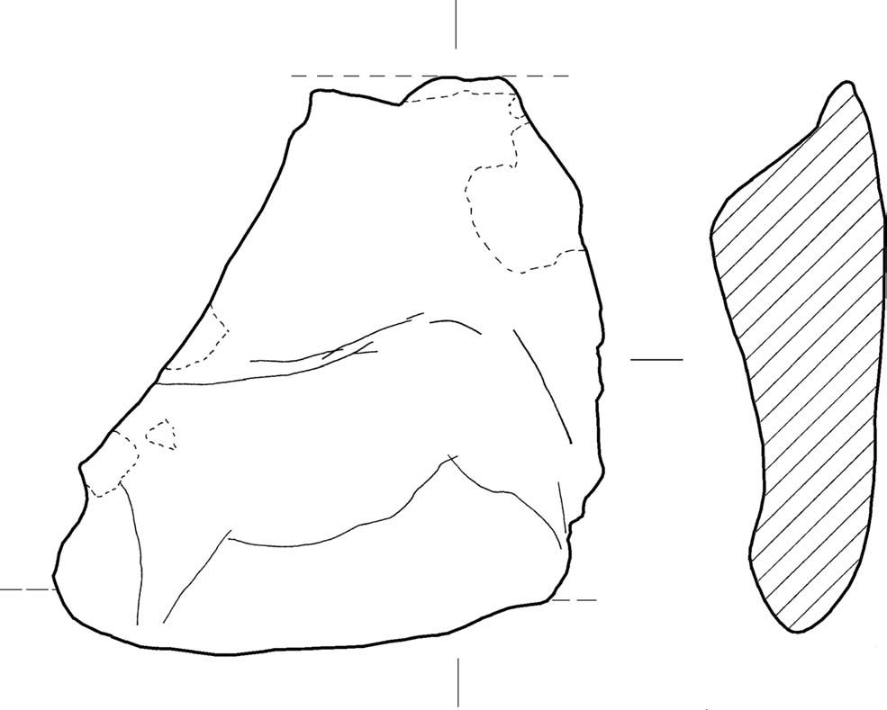
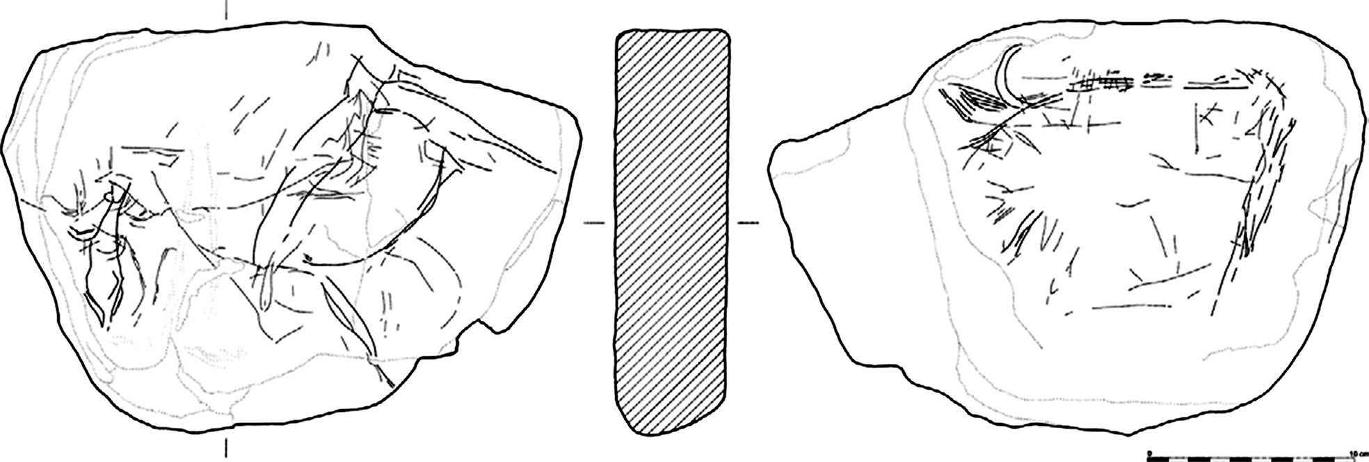
Graphic unit from plaque 2.
Schist plaque 99 × 108 × 33 mm. The surfaces are polished, the upper face is wavy, and the lower concave. The edges are rounded.
The slab has been used as an anvil during the use of a compresseur and/or a hammer stone, with numerous traces of crushing and breakages of one of the edges. Part of the etched pattern was removed by this activity.
This plate comes from the outer area of the site and we have some doubts regarding its stratigraphic position, but there are data that indicate that we can place it at the top of set B.
An unknown animal (maybe a bovine or equine), 85 mm wide and 48 mm high, was engraved on the upper side. It is formed by a dorsal line, the croup, a possible tail, a hind leg, an abdomen, a foreleg and the lower part of the chest.
Photo and text: García-Diez and Vaquero (2006)
Graphic unit from plaque 3.
Schist plaque 293 × 155 × 43 mm. Both faces are polished and flat; the contours are rounded. It was unearthed in the Asup layer and it is interesting to note that the sample of carbon dated 10 840 BP was gathered only 40 cm away the plate.
The central and left part of the upper surface is covered with red dye (S15, dark red - A. Cailleux code); iron oxide was found on both graphics units on this face.
Photo: Fullola et al. (2012)
Text: García-Diez and Vaquero (2006)
Graphic units from plaque 3. Upper face: A) hind, B) probable hind. Lower face: C) stag or hind, D) probable
hind.
The upper figure is a doe/hind (A), 106 mm in width and 91 mm in height, consisting of the jaw line, the nasofrontal line, the hairline, ears, neck, dorsal line, the rump, tail, buttocks, posterior leg, belly, a front leg and chest. The dorsal line, rump, neck and chest have short oblique lines in the figure and associated with the contour line; in the head there are dashes parallel to the lines of the jaw and forehead.
Below, a headless animal figure was engraved (B). This is probably a doe, 86 mm wide and 82 mm high, which is formed by the neck, dorsal line, the rump, buttock, a hind leg, a front leg and chest; two long slashes, surpassing the outline of the animal, are associated with neck and back. The rump and the buttock are associated with a curved line formed inside the figure.
Photo and text: García-Diez and Vaquero (2006)
Almost the entire lower face, and particularly the central and left sides, is covered with red dye (S13 - faint red and S15 - dark red) located above the graphics units. The lower figure is a stag or a hind (C), of 118 mm width and 65 mm in height, formed by the jaw line, the nasofrontal line, the forehead line, a possible mouth lune, ears, neck, dorsal line, rump, buttocks, hind leg, abdomen, the beginning of a foreleg and the chest; the character of the croup slightly protruding over the buttock may indicate the presence of a very short tail. By the well developed wide anatomy, and the height of the trunk and neck, this figure can be seen probably as a stag without horns.Text above: García-Diez and Vaquero (2006)
Above there is a less complete animal figure, possibly a hind (D), 123 mm in width and 83 mm in height, which is made up of the jaw line, the forehead line, an ear, neck line, dorsal line, croup, buttocks, posterior leg, a front leg and chest; back, croup, chest and neck exhibit, inside the figure and associated with the contour line, small oblique and parallel lines. In this underside there are other lines that do not form recognisable figures or signs.
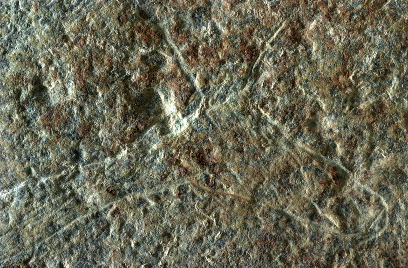
This engraving on schist is the head of the doe/hind A above - Don
Photo: Fundació Instititut Català de Paleoecologia Humana i Evolució Social (IPHES)
Source: http://www.iphes.cat/mol%C3%AD-del-salt
Plaque 4.
Schist plaque, 268 x150 x 66 mm.
Photo and text: García-Diez and Vaquero (2006)
The upper surface is partially polished, slightly concave and shows marks of percussion. The lower surface is polished and fairly flat; the edges are rounded or slightly rounded. There are small areas with a very faint red hue, whose interpretation is difficult without an analysis, but which may correspond to dye remains (iron oxide) or a chromatic alteration of the material due to the action of heat or an oxidation process of the mineral elements of the plate. This piece was found in the Asup layer, and a date of 10 000 BP was given to a piece of charcoal from a hearth directly on top of the plaque when found. The upper surface, which shows the marks of percussion after the creation of the engravings, has two graphics units.
The larger figure of the two (A) is an indeterminate animal (possibly a boar, bovid or equid), 103 mm wide and 69 mm high, which is made up of the back, the buttocks, the beginning of the buttock, a hind leg, abdomen and a forelimb; within the body and in the proximal part of the hind limb there are lines which tend to be parallel to the outline. Strong percussion has occurred in areas corresponding to the front of the body and the head prevents us from seeing if these interior lines were also etched in these anatomical regions.
To the right there is another figure (B), 57 mm wide and 25 mm high, interpreted as a possible equid, which consists of the jaw line, the hairline, the neck, a hind leg, belly, a front leg and chest; two lines are associated with the neck. An equid, 65 mm wide and 53 mm high, was etched on the underside (C). The figure is formed by the jaw line, the nasofrontal line, the forehead, an ear, cheek, neck, dorsal line, the rump, buttock, a hind leg, the groin, stomach, part a front leg and the chest.
In the interior area, the neck and chest have small parallel oblique lines, associated with the outline; the lines at the neck and their lower position relative to the dorsal line might represent the mane. On both sides there are other lines associated with the figures, but they are not representations or signs.
Photo and text: García-Diez and Vaquero (2006)
References
- Dousset ML., 2011: Habitation Fixe ou campement de fortune? Les dynamiques résidentielles chez les Aborigènes d’Australie, Techniques & Culture, 2011; 56: 62–77. doi: 10.4000/tc.5346
- Fullola J. et al., 2012: The Magdalenian in Catalonia (northeast Iberia), Quaternary International, 272-273 (2012) 55-74.
- García-Diez M. et al., 2002: La plaqueta gravada del Molí del Salt (Vimbodí,Conca de Barberà) i el grafisme Paleolític/Epipaleolític a Catalunya, Cypsela, 14, 159–173.
- García-Diez M., Vaquero M., 2006: La variabilité graphique du Molí del Salt (Vimbodí, Catalogne, Espagne) et l’art mobilier de la fin du Paléolithique supérieur à l’est de la Péninsule Ibérique, L'anthropologie, (2006), doi: 10.1016/j.anthro.2006.07.009.
- García-Diez M., Vaquero M., 2015: Looking at the Camp: Paleolithic Depiction of a Hunter-Gatherer Campsite, PLoS ONE, ONE 10(12): e0143002. doi:10.1371/journal.pone.0143002
- Tiffagom M., 2006: Estratigrafia del Molí del Salt, ERAUL, 113. Université de Liège, Liège.
- Vallverdú J., Carrancho A., 2004: De la Pierre à l’Homme. Essai sur une paléoanthropologie solutréenne, Vaquero M, editor. Els darrers caçadors-recollectors de la Conca de Barberà: el jaciment del Molí del Salt (Vimbodí), . Montblanc: Museu-Arxiu de Montblanc i Comarca, 2004. pp. 61-68.
- Vaquero M. et al., 2012: Temporal nature and recycling of Upper Paleolithic artifacts: the burned tools from the Molí del Salt site (Vimbodí i Poblet, northeastern Spain), Journal of Archaeological Science, 39 (2012) 2785e2796