Back to Don's Maps
 Back to Archaeological Sites
La Grotte de Jolias - a Magdalenian site at Prignac-et-Marcamps, France
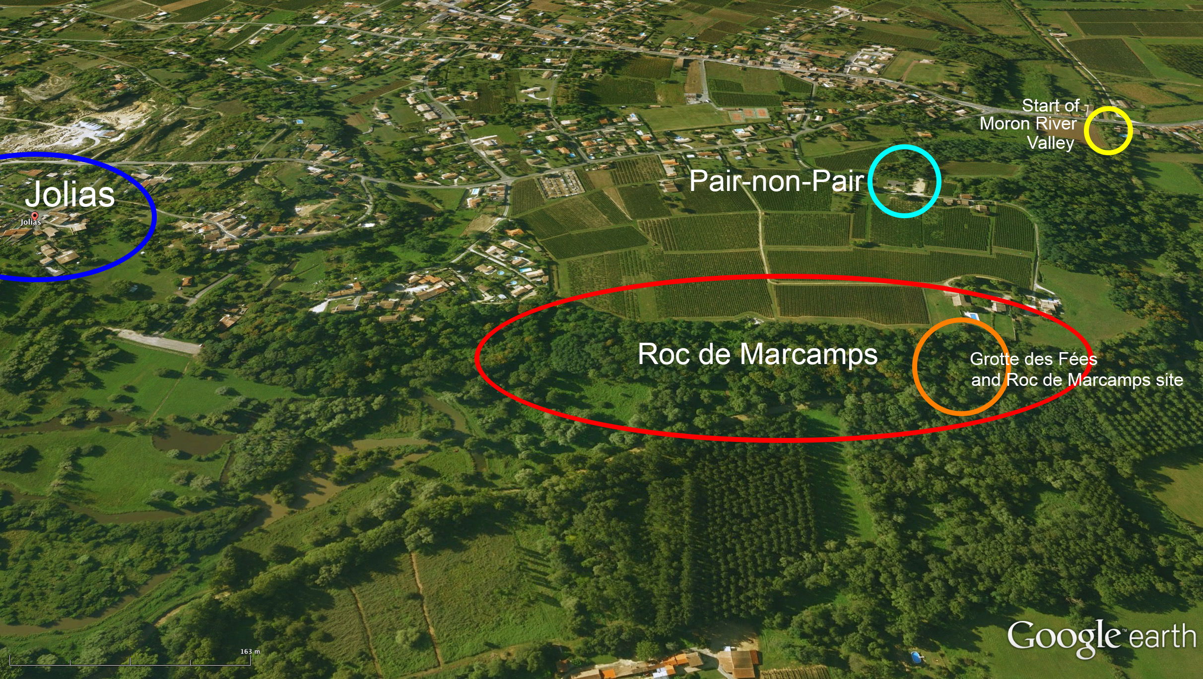
General view of the sites of Jolias, Roc de Marcamps and la grotte des Fées.
Photo: Google Earth, imagery from 2006
Additional information to locate the sites by Don Hitchcock, based on the description of Daleau (1874)
Paper by Daleau et Gassies in pdf form.
Commune de Marcamps (Gironde)
Daleau et Gassies (1874)
Translation: Don Hitchcock
The sub-Pyrennean part of the South West region of Aquitaine seemed completely devoid of those rock shelters which were so liked by the first inhabitants of this land, in prehistoric times, the abris and caves which are so abundant in the Vézère Valley.
For eight years, carrying out our investigations into the steep hills surrounding Bordeaux, we often asked ourselves why there was such a shortage of these abris, while our neighbouring Dordogne region was so rich in archaeological sites, almost reaching the limit of our ability to administer them, yet geologically differed little from the standpoint of the position and orientation of the highlands.
Finally, in 1872, at the end of the congress of the French Association for the Advancement of Science, M. Fayard, of Saint-Emilion, showed us worked flint and bones collected by him under an abri, at Font-Caban, near his property, and which showed a complete analogy with those of les Eyzies.
This first breakthrough in our chain of investigations encouraged us to excavate this shelter, and on 27th July 1873, with the help of our Gironde colleagues, we were able, during an excursion, to procure a quantity of objects in no way inferior to those of the Vézère, and we lost no time in exhibiting them in the Prehistory Museum of Bordeaux. These results rekindled the flame of the hope that we had always kept burning, that we should find in our region evidence of primitive man, of those troglodyte groups living under overhanging rocks, who had lived off the products of hunting and fishing.
During the first days of April 1873, many of our Linnaean colleagues, MM Linder, Brochon, Motelay and Daleau, made a geological and botanical excursion to the town of Marcamps between Bourg and Saint-André de Cubzac. M. Daleau remarked that a steep cut in a quarry had left a trace of a black undulating line, in which were mixed charcoal, burnt bones and flint debris.
It was enough to arouse the spirit of enquiry in these gentlemen, who searched in the mixture and brought us items that denoted the presence of a hearth, evidence of an abri, with all the usual tools used by people of prehistory. We promptly took the decision to excavate this shelter, and in May we returned to the site with the owner, Mr. Page, who was willing to employ a quarryman to begin the excavation of what remained of the cave.
We say what remained of the cave because extraction of limestone had left us with only one third of the original deposit. The leavings were thrown pell-mell into the bottom of the quarry, and it would have needed a lot of money for labour to sieve and extract piecemeal the items in the spoil, and would have required considerable time for its completion, which we did not have. We would not have shrunk from this labour, if the resulting excavations could have allowed us to make sense of our findings, but since that would not have been possible, we had to limit ourselves to simply the removal of the undisturbed section which remained.
The hamlet of Jolias, Marcamps town, canton of Bourg (Gironde), is built like an amphitheater at the bottom of a very narrow valley; its orientation is northwest-southeast. Several excellent springs tumbled to the bottom of the valley, and it is not without reason that the rock shelter was chosen above one of them because of its abundance and clarity by the people who needed that indispensable element of their livelihood.
The rocks belonging to the formation of the 'Calcaire à astéries' are cut to size and shipped to Bordeaux via the Moron Creek, a tributary of the Dordogne. This stream, small in summer, becomes stagnant for the rest of the year and its waters then form the vast marshes which now take the name of Magrine and where, certainly, we can find traces of piles driven into the marshy bottom, because these aqueous areas are inhabited by many species of freshwater fish that provided food for primitive peoples in ancient times, and thus invited them to build stable homes above the water, that kept them safe from the incursions of wild beasts.
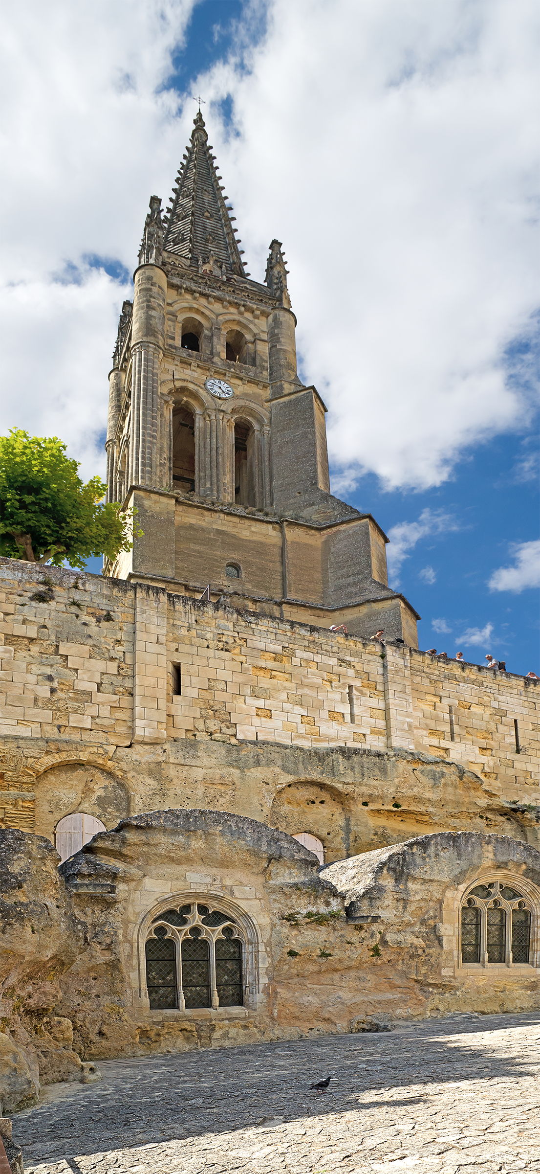
Calcaire à astéries or 'Starfish Limestone' is also called 'Bordeaux stone' or 'Saint-Emilion limestone', and owes its name to the countless small skeletons of starfish, principally the genus Asteria.
Monolithic church of Saint-Emilion of the eleventh century, known as the second monolithic church in the world, Saint-Émilion, Gironde, France, built of Calcaire à astéries.
Photo: Didier Descouens
Permission: Creative Commons Attribution-Share Alike 4.0 International license.
L'abri de Jolias would have had greater importance before quarrying began. The part we were able to excavate represented only about a third of its former size, but at least we had the good fortune that the hearth was still in position, and we were able to find a good approximation of the representation of all the objects used by the inhabitants, including the usual utensils, weapons, etc, and the bones of the animals used by them for food and other resources such as hides and tools.
The cave had been formed in limestone, and was not a homogenous and solid structure, but had been formed by isolated blocks, restrained only by natural buttresses, no doubt through which there was a crack in the roof from which smoke from the fire could exit. One day after torrential rain, or as a result of the thaw, the parts separated and the roof collapsed. The people, probably forewarned by scree, hastened to flee, carrying what they could to escape the collapse, and no one has been buried. We could not find any evidence allowing us to determine to which race they belonged, but they lived in the cave for a long time, with the debris of their lithic industry and their cooking testifying to the long duration of their tenancy.
A small valley so well sheltered on one side against the rigours of the cold, and on the other against those of great heat, was an ideal place to live during the time of the stone age. Indeed, the sheer walls plunging into the ground and bare in places, allows us to see, here and there, more or less substantial openings which provide to the trained eye traces of habitation, and the many flints scattered over the surrounding land are indicators of occupation which it would be imprudent to ignore.
One of us, very happily situated by living here, and having a lot of knowledge about the area, searched constantly for geological features and for traces of prehistoric man, was joined in September 1872 by M. Emile Maufras, of Pons, with whom he toured part of the district of Blaye. They found little of substance to reward their labours, until finally discovering the abri of Jolias, on 11th April 1873.
After starting the excavation, they showed us debris from the hearth, charred bones and flint tools, to give us an idea of the wealth of the site, wealth which was confirmed by certain objects of familiar form. They invited us to go to the scene to verify the discovery for ourselves. A first visit proved to us that our predictions were correct, and we decided to methodically excavate the site, with the help of the owner and a quarry worker, putting to one side everything we found, no matter how small, with great care.
Ten days were sufficient for us to clear the fireplace area, remove the stones of the fallen ceiling, and get to the part which we supposed to have been the entrance, to the north east. As we have indicated, l'abri Jolias was in the Calcaire à astéries, a fossiliferous limestone, separated from the major part of the slope, that of the base, looking to the southwest.
First, the local road divided it in two, and after the extraction of building stone removed the middle of the cave, we were left with the perpendicular section above the hearth, forming a wave shape at the bowl shaped centre.
It is in this part that the seeping and subsequent deposition of lime rich ground water caked all objects to form a solid mixture that had to be broken up to extract the flint and bones. Above this mixture lies a layer of red earth, where we met with several fragments of horse, bovid, badger, wolf, hare (or rabbit), and many jaws of rodents and bats, as well as the upper shell of a Testudo, a freshwater tortoise. Below this layer of red earth lay the broken stones of the cave vault, allowing us to see in the upper middle part the results of the collapse that had occurred.
This may be seen in the cross section or coupe shown here.
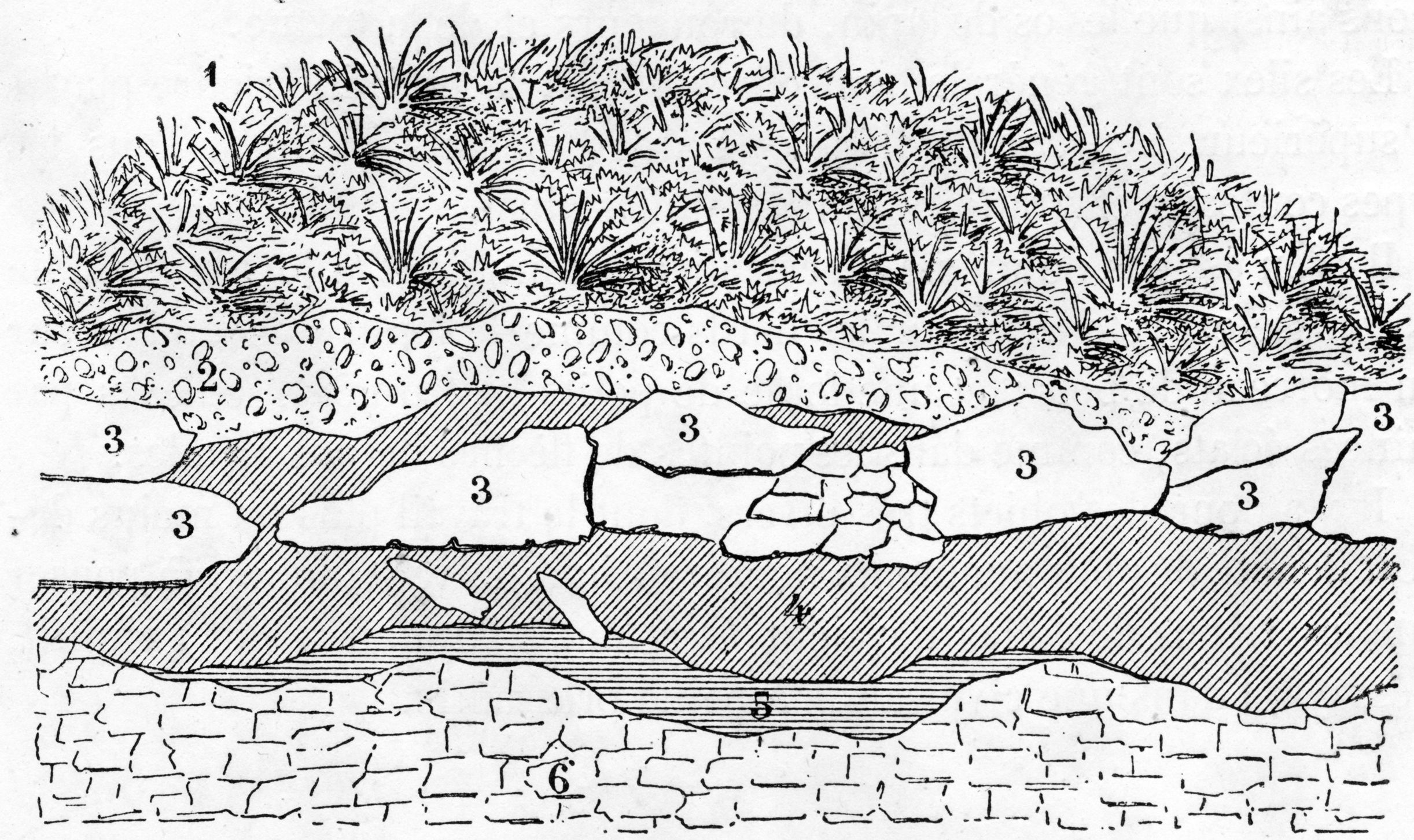
1. Topsoil.
2. Black reddish earth created from the collapse of the vault of the cave.
3. Blocks of limestone that formed the ceiling of the cave.
4. Upper hearth area, of red soil, with burnt bones included, thickness 5 cm, length ca 250 cm.
5. Stalagmitic layer, with flint and bovid bones, but especially horse bones.
6. Fossil-rich limestone, compact, used for building.
Photo: Daleau et Gassies (1874)
After searching all accessible parts and clearing the collapsed stones, we could identify the presence of more than twenty horses, three aurochs, five mouflon and goats, a badger and several rodents. Worked bones appropriate to daily needs are few, or at least finished; they consist simply of a chisel with notches, several awls and a polished and pierced tooth, belonging to a wolf.
All long bones are cracked with the obvious aim to extract the marrow. We found fragments of jaws and numerous incisors and canines of horses and aurochs, but no skulls. Numerous flints were found in the various styles of la Vézère, le Moustier, Cro-Magnon and les Eyzies. Synchronism between Jolias and Solutré can be seen in small tools for tattoos and chiseling which are retouched with special care, coupled with the presence of many horses. Certainly, for us, the Jolias site is the oldest, and can relate to both le Moustier and Solutré.
In the hearth, and in the most concave part of it, numerous stones of schistose quartz and quartzite were placed around the fireplace to serve to contain the fire, as is still done by shepherds here. Other stones, not from this locality, served as hammer stones because of their angular shape and strong nature, mostly in quartzose sandstone, and bear many traces of blows applied on hard and resistant materials. These pebbles of different sizes have been chosen so as to be easily gripped by the hand, into which they fit snugly. There are some that are up to 10 or 15 centimetres long.
We have found no traces of pottery, except for some debris in the upper part, which must come from a time after the collapse of the vault.
The flints are generally cleaved to three faces, with a lower plane, and on top two inclined faces meeting at a median keel. Most knives and scrapers are designed in this way. It is not the same, however, for certain scrapers whose rounded and thick shape is retouched on the edges as would be done for a gouging a piece of wood, and a host of small tools made of thin flakes such as the arrowheads found here in our Department of Landes. There are, then, some very different objects, including some more or less delicate work, reflecting the trial and error of the people of the Jolias area in creating their tools.
Fauna
List of animal remains found at Jolias
Lower bed, at the hearth.
1. Aurochs?
2. Horse.
3. Wolf.
4. Fox.
5. Bear?
6. Reindeer (Cervus tarandus).
Upper bed, diluvium.
1. Pig.
2. Rabbit.
3. Sheep.
4. Badger.
5. Shrew.
6. Mouse.
7. Bat.
8. Water Rat
9. Tortoise.
10. Helix limbata, freshwater mollusc.
11. Helix cornea, freshwater mollusc.
12. Helix lapicida, freshwater mollusc.
13. Cyclostoma elegans, now Pomatias elegans, the round mouth snail or land winkle.
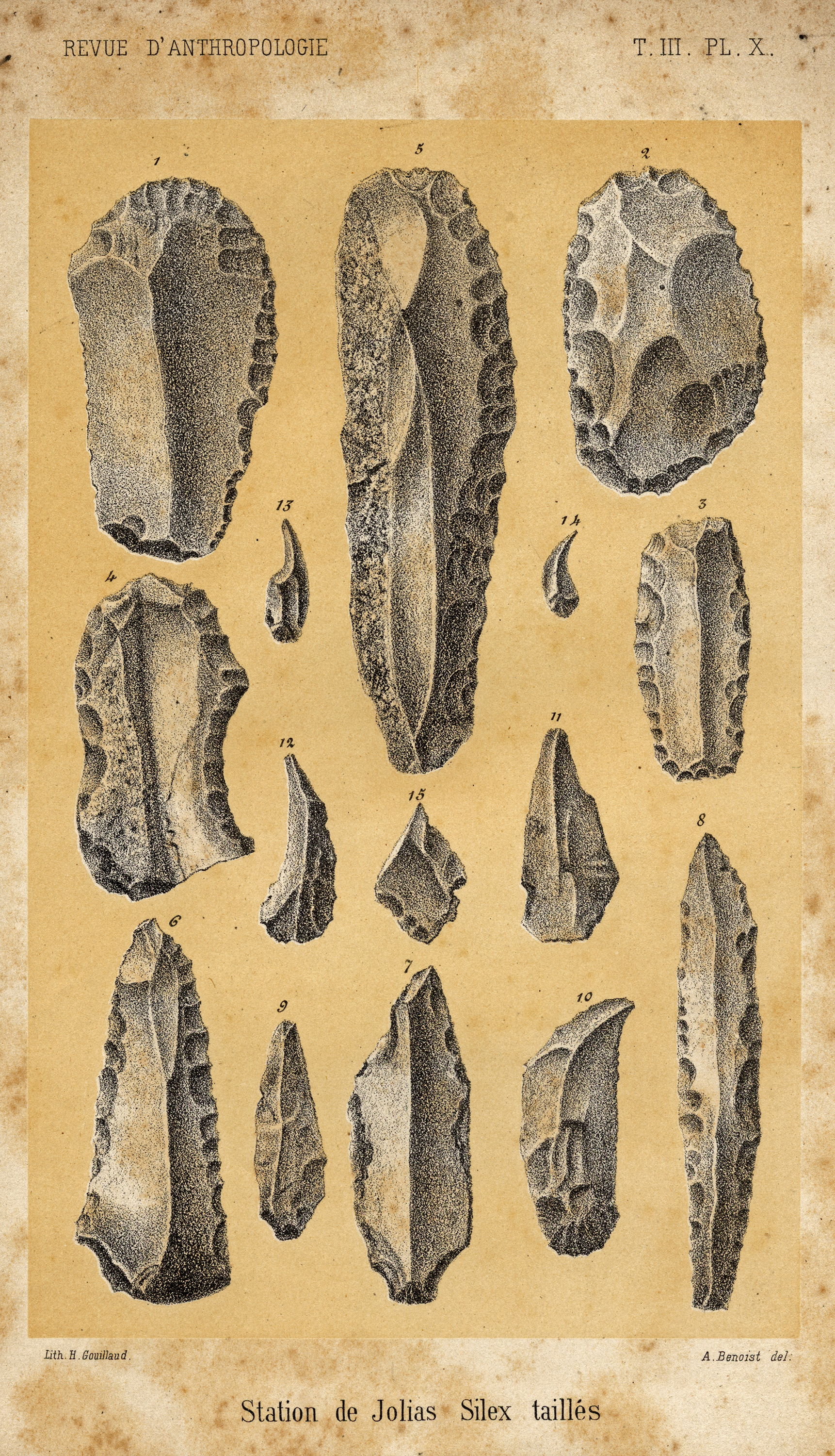
Plate X
1 Scraper with a flat bottom and with two flat surfaces on the upper surface forming a keel, finely retouched on the right side and the top.
2. Semicircular scraper with large flakes taken from its upper and lower surfaces, finely retouched all round the edge.
3. Scraper with a large lower flake removed, keeled on top by two parallel flakes and finely retouched all around.
4. Scraper for shaping bones, with the bottom right cut into sickle or notch, well retouched all round, except at the base.
5. Scraper/saw, lanceolate, five flakes removed above, one underneath, and retouched on the right side.
6. Spear head with five upper flakes removed, one on the lower surface, less strongly retouched on the lateral sides.
7. Keeled arrowhead, with two upper flats, one beneath, little retouching.
8. Tranchet flake curved on the lower flat, keeled on top, very pointed at the front, truncated at the bottom.
9. Arrowhead with a keeled upper surface, one lower flat, no retouching.
I0. Curved scraper, flat on the lower surface, five unequal flakes taken off on top, edged on both sides, the base retouched.
11. Arrow head a little obtuse, one flat lower surface, two above forming a keel.
12. Curved scraper, flat on the base, six unequal flakes removed from the top, without retouching.
13, 14 Sharp knives with several flakes removed from the upper surface, some from the lower.
15. Arrowhead, unevenly retouched.
Photo: Daleau et Gassies (1874)
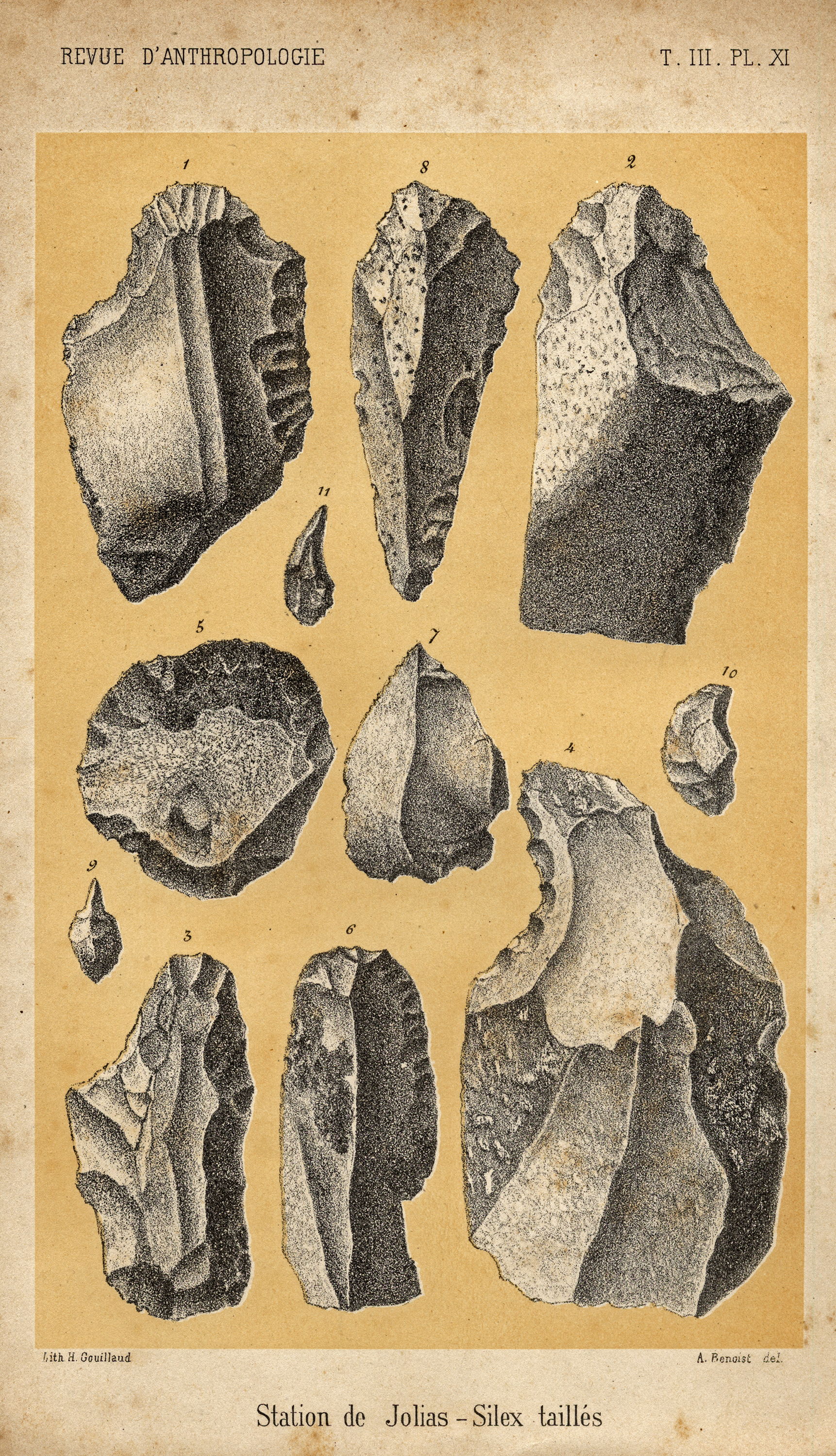
Plate XI
1. Oblique scraper, with two keels and two flats on the upper surface, one on the lower, very heavily retouched on the upper surface and on the right side, in the form of a sickle (notched) on the upper left.
2. Quite different to the previous example, this scraper is planar on its lower surface, rounded above, with three uneven flats, angular on the right edge and with the upper part heavily retouched.
3. Triangular scraper, large lower flat surface, many unevenly sized flakes taken from the upper side, with an obtuse, unevenly shaped sickle shape (notched) on the left, heavily retouched all around.
4. Scraper with a large lower flat surface. On the upper side a curved sickle shape on the left, strongly serrated with teeth like a saw, the lower part with a sharp cutting edge.
5. Scraper strongly rounded at the top by pressure flaking to make a gouge.
6. Scraper with a wide lower flat surface, with three large flakes removed from the top, heavily retouched on the right side.
7. Point with two large flakes removed, and very sharp edges.
8. Spear point, flat underneath, flakes removed on top and a little retouched along the edges. .
9, 10, 11. Straight points, slightly oblique and semicircular, probably for tattooing.
Photo: Daleau et Gassies (1874)
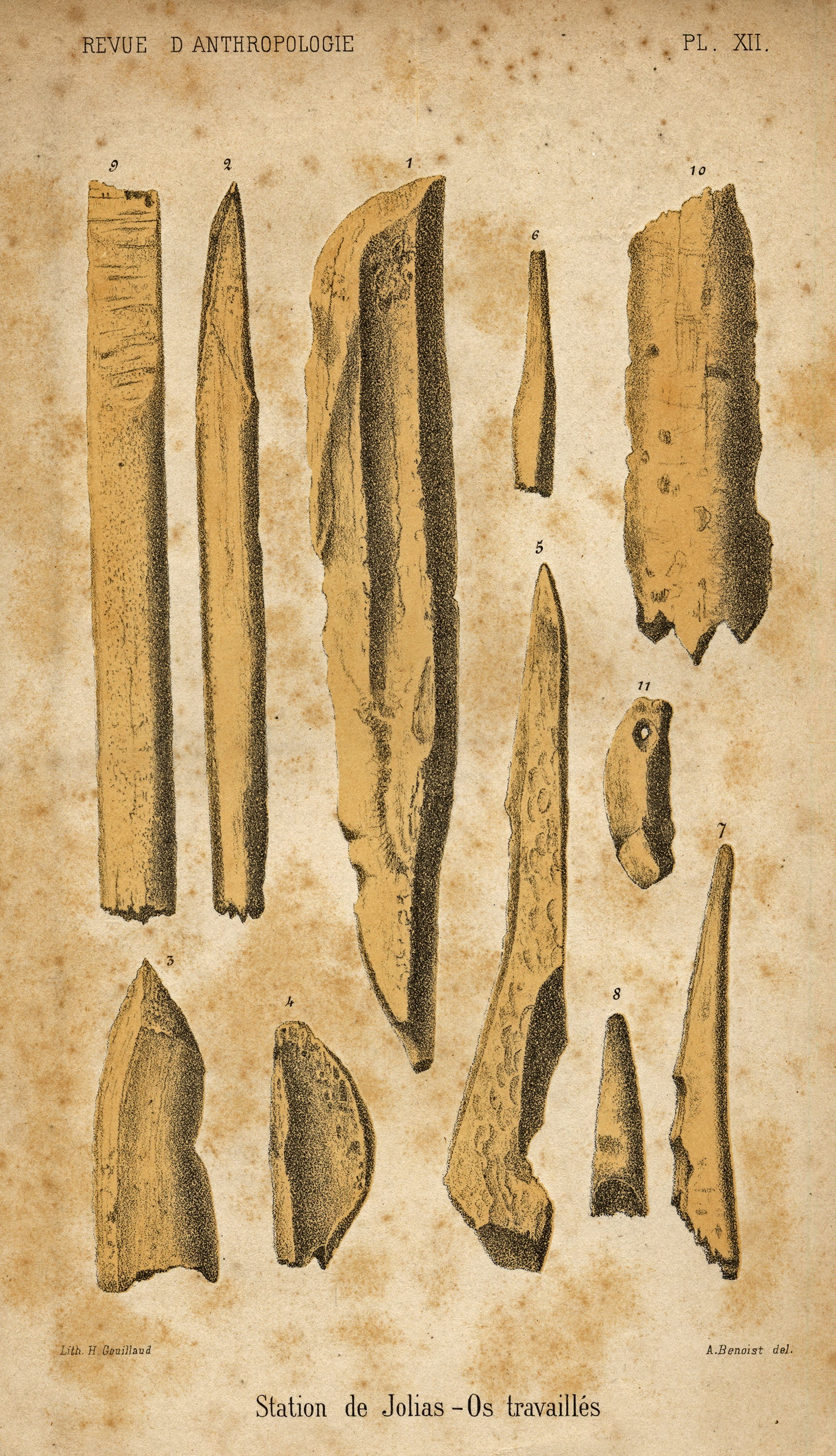
Plate XII
1. Awl made of bone, rounded at the top, pointed at the base.
2. Very sharp awl, used as an arrowhead.
3. Bone with the tip worked into a point by three flakes.
4. Bone made into a semicircular shape, perhaps as a polisher.
5. Slightly curved awl, pointed at the top, carved near the base.
6, 7, 8. Small punches, polished.
9. Flattened cylindrical chisel, sharpened and topped with strong transverse ridges on the cutting part.
(it is much more likely that this is the end of a spear point with a bevel for attachment to the shaft, the spear point being broken off - Don )
10. Instrument for making netting, or at least for winding a thread around.
11. Canine of a carnivore pierced with a suspension hole.
Photo: Daleau et Gassies (1874)
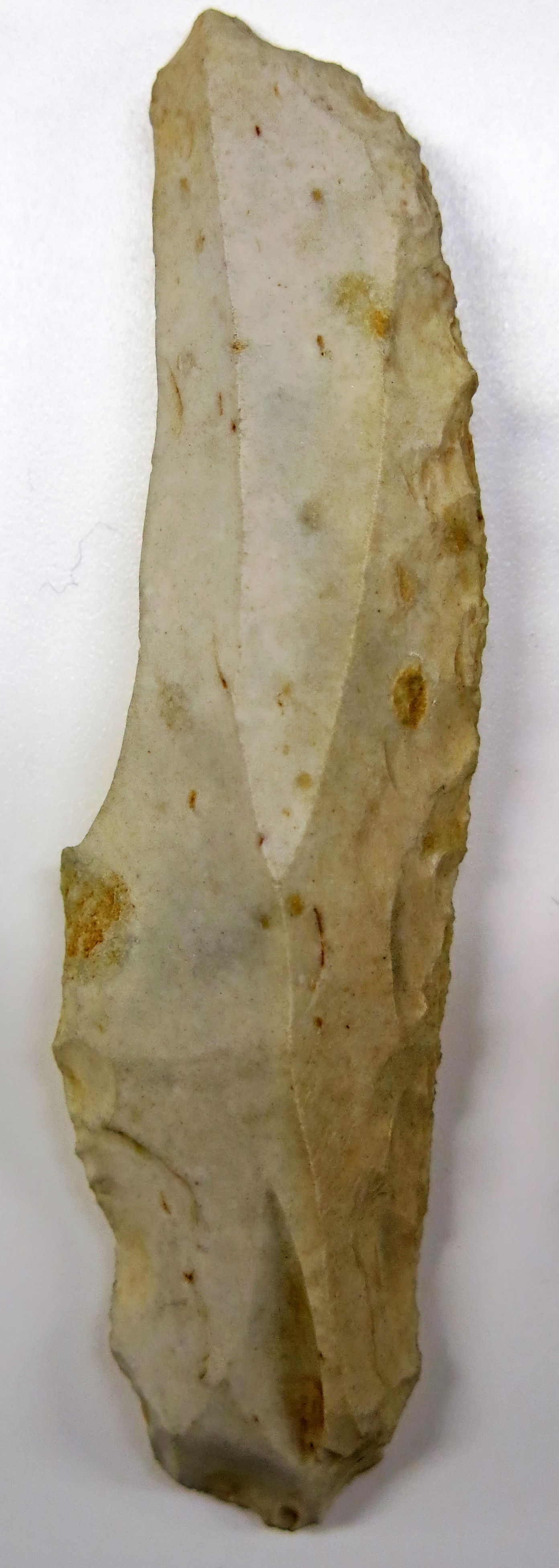
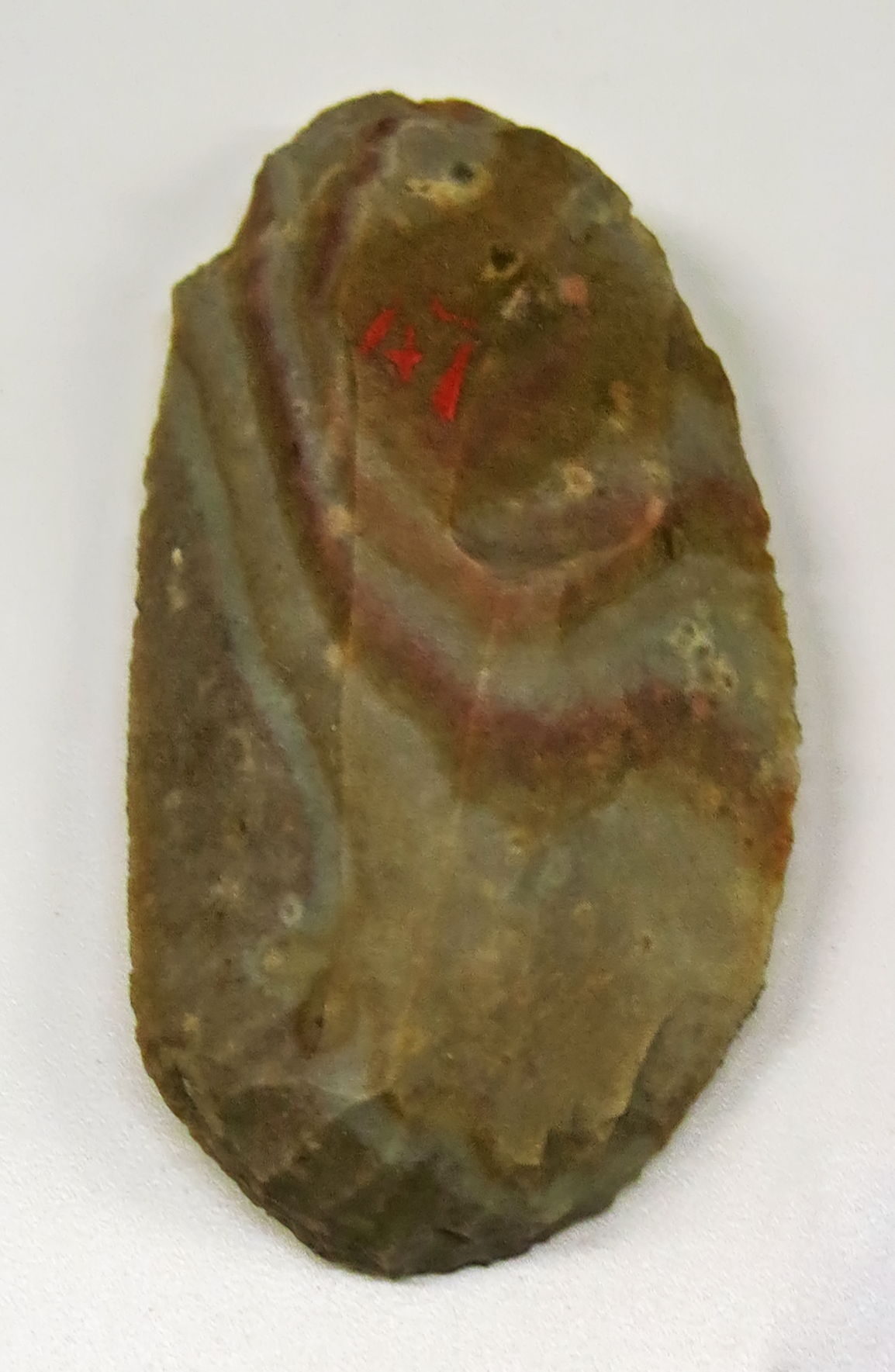
Burin, Grotte de Jolias, Prignac-et-Marcamps
Photo: Don Hitchcock 2015
Catalog: 60.913.8
Source: Original, Musée d'Aquitaine à Bordeaux
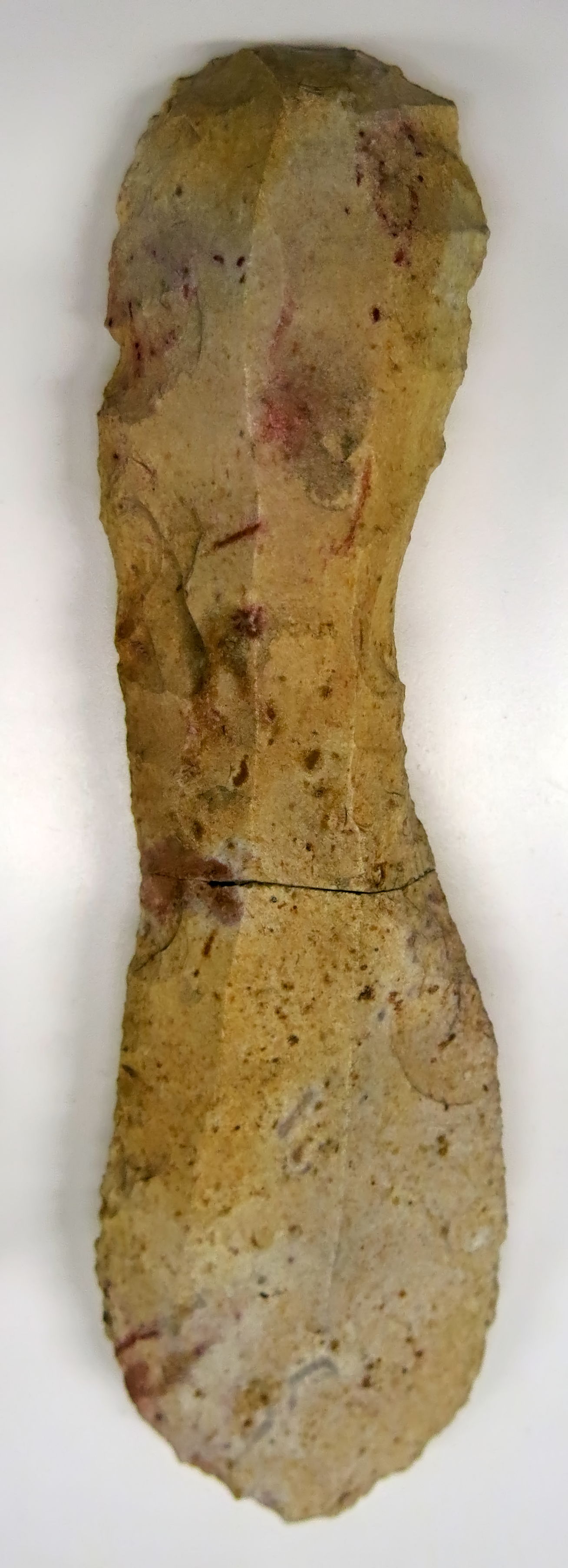
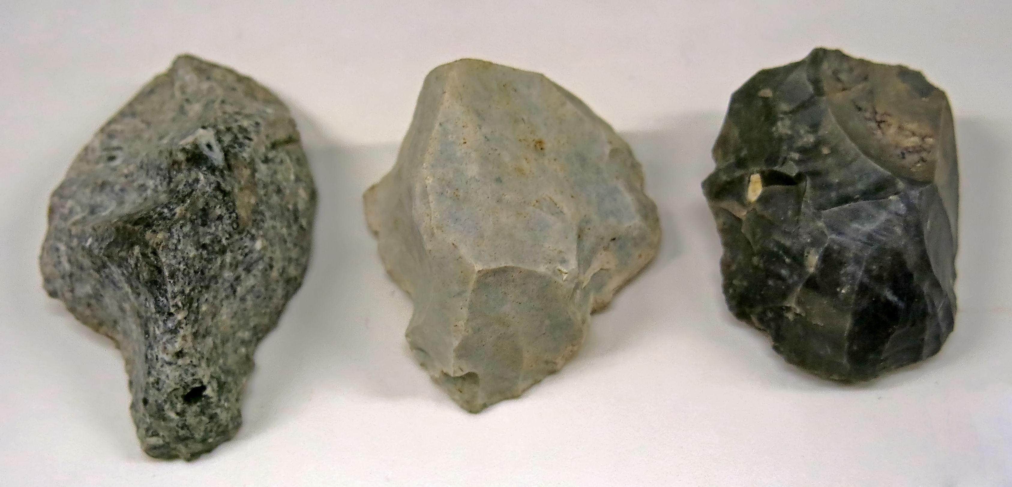
These three tools are labelled as being Aurignacian blades, and coming from Grotte de Jolias, Prignac-et-Marcamps and Laussel, Marquay.
Judging from the catalog numbers, it is possible that the left hand tool is from Grotte de Jolias, and the other two are from Laussel.
They are large thick Aurignacian blades, retouched bilaterally and of the type known as waisted blades, or in French, 'strangled' blades, a very appropriate term.
Photo: Don Hitchcock 2015
Catalog: 60.913.3, 61.3.80, 61.3.91
Source: Original, Musée d'Aquitaine à Bordeaux
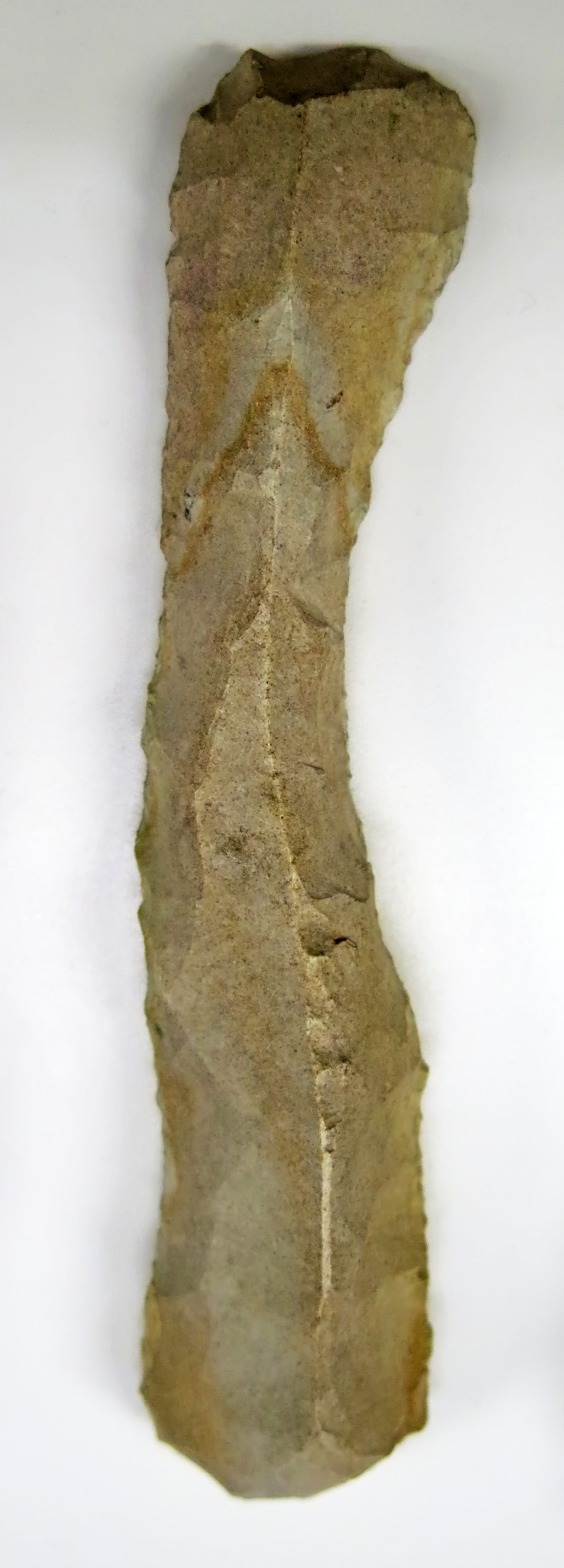
Grattoir from Grotte de Jolias.
Photo: Don Hitchcock 2015
Catalog: 60.931.1
Source: Original, Musée d'Aquitaine à Bordeaux
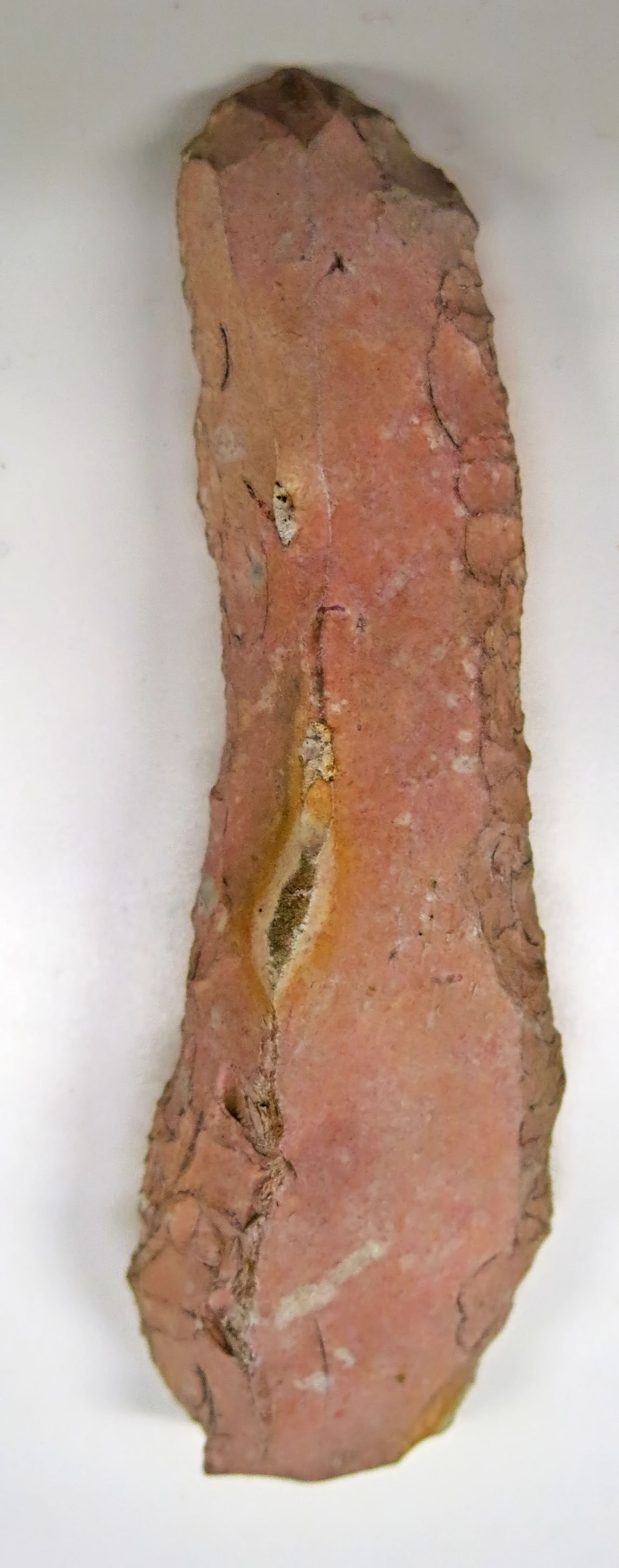
Grattoirs à museau, nosed shaped scrapers from Grotte de Jolias.
Photo: Don Hitchcock 2015
Catalog: 60.913.5
Source: Original, Musée d'Aquitaine à Bordeaux
References
- Daleau, F., Gassies J., 1874: Notice sur la station de Jolias, Commune de Marcamps (Gironde), tiré à part extrait de la Revue d'Anthropologie, 7 pp., 3 planches lithographiées, Tome III, 1874.
- Daleau, F., 1874: Grotte des Fées (Age du Renne), située au Roc, commune de Marcamps, canton de Bourg (Gironde), Société archéologique de Bordeaux, Volume 1, Bordeaux, France, 1874 pp. 110-119, two plates.
Back to Don's Maps
Back to Archaeological Sites