Recent additions, changes and updates to Don's Maps

I am now working on egypt and various apparently palaeolithic finds in England.
See:
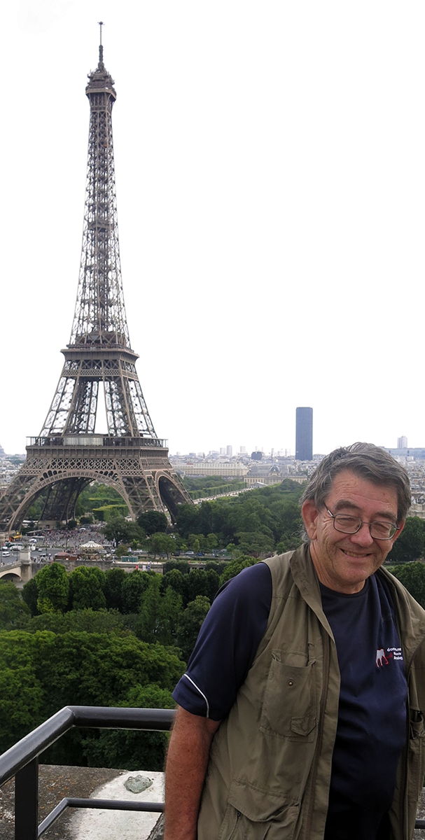
Photo: Me in Paris, on top of the Musée de l'Homme.
 This sitemap link provides access to all the pages on my site.
Most searches for subjects covered in Don's Maps can be accomplished by searching on this page for the subject you are after.
 Maps of the Earth's Children Series including a map of Journeys in the Land of Painted Caves, the last book in the series.
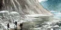
Maps include the true extent of the ice in the last ice age, as well as maps of The Territory of the Zelandonii, Journeys in Clan of the Cave Bear, local area around the cave in Clan of the Cave Bear, The Valley of Horses, Iron Gates map, local map of the Sharamudoi, local map of The Mammoth Hunters Lion Camp, map of Ukraine, map of The Plains of Passage, Clickable map of the Plains of Passage, Donau Mouth to First Snow from the Plains of Passage, The Encounter with the S'Armunai, Wurm and Riss Glaciation in the headwaters of the Donau (Danube), How I draw the maps.
 Ancient Egyptian culture from its beginnings through the dynasties to the Ptolemaic period and its eventual decline as a Roman Province, told through reference to its mummies, statues, burial practices and artefacts.
Although my first love is the stone age, mostly before 10 000 BP, I have also become interested in the magnificent works of art produced in ancient Egypt. This set of pages is being constantly updated.
Ancient Egyptian culture from its beginnings through the dynasties to the Ptolemaic period and its eventual decline as a Roman Province, told through reference to its mummies, statues, burial practices and artefacts.
Although my first love is the stone age, mostly before 10 000 BP, I have also become interested in the magnificent works of art produced in ancient Egypt. This set of pages is being constantly updated.
Last updated Tuesday 07 July 2026
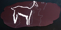
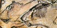
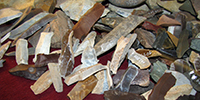
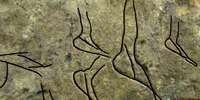
 John Darvill has made many discoveries of what appear to be objects made by prehistoric humans in various parts of the UK which are very similar to ice age objects from Continental Europe. Because John Darvill is not a university teacher or researcher, these are not available for publication in scientific journals. Note also that the objects were surface-collected and thus currently hold little to no scientific value, but are fascinating nevertheless.
Last updated Monday 06 July 2026
 Ancient Egyptians used corundum, often in the form of emery (a rock rich in corundum) as a high-hardness abrasive to work granite and other hard stones such as andesite and basalt by grinding rather than cutting. Because corundum (hardness 9 on the Mohs scale) is significantly harder than the quartz (hardness 7) and feldspar (hardness 6) in granite, it allowed them to effectively cut, drill, and polish the hard stone.
Last updated Tuesday 12 May 2026
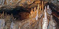
 Giant Wallaroo Gallery, near Magnificent Gallery. Several more images with descriptive text have been added.
Last updated Saturday 11 April 2026
 Mesopotamia is the site of the earliest developments of the Neolithic Revolution from around 10 000 BC. It has been identified as having inspired some of the most important developments in human history, including the invention of the wheel, the planting of the first cereal crops, and the development of cursive script, mathematics, astronomy, and agriculture. It is recognised as the cradle of some of the world's earliest civilisations. A summary of the Mesopotamian list of Kings has now been added.
Last updated Friday 03 April 2026
 Göbekli Tepe was built by hunter-gatherers from the Pre-Pottery Neolithic period (around 9600-8200 BC), a significant discovery showing that these early people did not just settle agricultural communities, but were capable of complex monumental architecture for social and ritual purposes. Archaeological evidence suggests nomadic groups gathered to construct the large, T-shaped pillars and enclosures using stone tools, challenging the idea that complex societies only arose after farming.
Last updated Saturday 21 February 2026
 The history of the Earth from the beginning of the earth to the end of the dinosaurs, and a selection of the animals and plants from the Precambrian to the Cretaceous. The page includes maps of the continents of the earth as they travelled back and forth across the globe. Especially interesting are the fossils from the Burgess Shale, famous for the exceptional preservation of the soft parts of its fossils. At 508 million years old (middle Cambrian), it is one of the earliest fossil beds containing soft-part imprints.
Last updated Thursday 29 January 2026
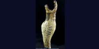
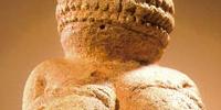
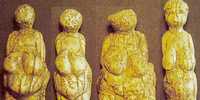 Avdeevo - a Palaeolithic site with strong links to Kostenki. The Avdeevo venus figures are quite variable, but most depict mature women in various stages of the reproductive cycle. The famous double venus was found there. Avdeevo is located on the Sejm River near the city of Kursk, Russia. Two oval living areas surrounded by semisubterranean lodges and pits have been identified at Avdeevo. Both were occupied between 21 000 and 20 000 BP. The tool inventory consists of Kostenki knives, shouldered points, and leaf points on blades.
Last updated Saturday 18 October 2025
 Egyptologists have discovered the first tomb of a pharaoh since Tutankhamun's was uncovered over a century ago. King Thutmose II's tomb was the last undiscovered royal tomb of the 18th Egyptian dynasty. More artefacts from the time of Thutmose II have been included.
Last updated Wednesday 08 July 2026
 Birdstones are small, abstract stone carvings that resemble a bird and are thought to have been used as a weight for an atlatl. They are generally three to four inches long and less than two inches tall. They are found at archaic sites in midwestern and eastern North America, including the Great Lakes region and east of the Mississippi River. The majority are made from banded slate, particularly the greenish-grey Huronian variety, but other stones like porphyry have also been used.
Last updated Saturday 21 December 2024
 Accessing the collection of rock art photographs by Heinrich Wendel, who documented many of the rock art sites in the Franco-Cantabrian region between 1964 and 1970 - the Neanderthal Museum has kindly made available to the general public the collection of superb photographs from the Wendel Collection. This page will show you how to access the page and to download any files you wish to use.
Last updated Thursday 12 December 2024
 Pasiega Cave in Spain was of mostly academic interest until the discovery that some of the art in the cave may have been put there by Neanderthals. This result has now been discredited. Here is the background to that story, with many drawings of the art of the cave from the old master himself, Breuil. A large number of images of the cave from the Wendel collection have now been added to this page.
Last updated Monday 02 December 2024
 From 1964 until his death in 1980, the collector Heinrich Wendel was head of set design at the Deutsche Oper am Rhein in Düsseldorf and one of Germany's most renowned stage designers. The design of spaces through light and projection art was a central part of his artistic work. With this in mind, he made several trips to the Franco-Cantabrian region between 1964 and 1970 with the aim of finding inspiration for his work in prehistoric cave art. He wrote an important paper on on ice age religion, translated here.
Last updated Tuesday 15 October 2024
 The Neo-Assyrian Empire was a powerful state that existed in the ancient Near East from 911 BC to 609 BC. It was the largest empire in the world at the time and covered much of modern-day Iraq, Syria, and parts of Iran, Turkey, and Egypt. The Neo-Assyrians were known for their military might, efficient administration, and innovative use of technology, including the development of siege warfare and the use of iron weapons. They also had a well-organised system of government, with a king who had absolute power and a bureaucracy that helped him govern. More images and text have been added.
Last updated Saturday 30 May 2026
 Another ivory animal sculpture has been found at Hohlefels, an otter. The small figure is around six cm long, and is almost 40 000 years old.
Last updated Saturday 27 July 2024
 We spent 17 days cycling from Amsterdam to Copenhagen in 2014. It was a great trip, with the highlight being the Viking ships Museum of Roskilde.
Last updated Monday 08 July 2024
 The Petrie Museum of Egyptian Archaeology in London contains 80 000 objects, making it one of the world's largest collections of Egyptian and Sudanese material. William Matthew Flinders Petrie conducted many important excavations in Egypt, and sold his collection of Egyptian antiquities to the University College in 1913, transforming the museum into one of the leading collections outside Egypt. This page is dedicated to the photographs I took there, and will take some time to complete.
Last updated Thursday 14 March 2024
Ice age hunters of Northern Europe, hunting reindeer and European elk (moose) as well as utilising other food and shelter resources, moved into the periglacial tundras after the last Glacial Maximum, ca 20 000 BP. More information has come to hand about the entry of Homo sapiens into the area now known as Finland in the period following the collapse of the Baltic Ice Lake.
Last updated Saturday 27 April 2024
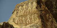
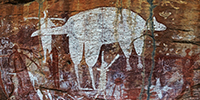 Laura in north Queensland, on the Cape York Peninsula, has many sandstone walls protected by overhanging ledges, which are the site of complex and rich rock art by Australia's First Nations people. More images and text have been added to this page which features the Magnificent Gallery.
Last updated Saturday 11 April 2026
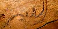
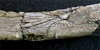
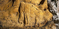
 L'abri du Renne de Belcayre (Dordogne) is on the Vézère river, Commune de Saint-Léon-sur-Vézère, near the Château de Belcayre. In 1924 Franck Delage excavated this site and others close by to the Abri du Renne. It is important for the discovery by Delage of an Aurignacian image now thought to be of an ibex rather than a deer or reindeer, pecked into a rock.
Last updated Sunday 07 January 2024
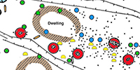 Bilzingsleben in Germany near Halle, is globally one of the most important sites of early human history. At just six other locations in Europe has it been possible to recover skeletal remains of Homo erectus. Only here, however, structures and material remains contain such astonishing details as to allow extraordinary insights into the life and behaviour of this archaic hominid. This is the only record and map that we have of a complete and detailed Homo erectus living site.
370 000 years ago, a small group of hominids established a permanent camp site on a lake shore. They left behind a large number of tools, artefacts, and food remains. In this carefully chosen locality it was possible to identify areas for living, working, and other activities. To date 1600 m2 of this site have been excavated. The remains of hearths and circular shelters provide ample evidence for their advanced stage of development. The most impressive remains are those of Homo erectus himself, which allow us to come face-to-face with our ancestors and the earliest known evidence for abstract thought.
Last updated Wednesday 22 April 2026
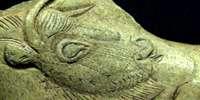
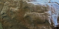 Fourneau du Diable is a prominent cliff face on the road leading to the east from the village of Bourdeilles, beside the river Dronne. It was once a settlement in the late Solutrean, and lithic and bone industries from that time were excavated there, but the most important discovery was of a large limestone block with several well executed sculptures of aurochs carved on its face.
Last updated Friday 15 September 2023
Index of caves and rock shelters with wall paintings and engravings Last updated Wednesday 08 February 2023
 The Mladečské Caves are a cave complex in the municipality of Mladeč in the Czech Republic, about 80 km north east of Brno. The site is a valuable resource for artefacts from the Old and Middle Palaeolithic.
Last updated Wednesday 22 April 2026
 Les Combarelles in the Dordogne, with more than 600 images on its walls, most of them engraved, is considered to be one of the major sanctuaries of Magdalenian culture. This extraordinary site was discovered in 1901. Beyond the entrance of the cave two galleries diverge. The largest one, now open to the public, is a narrow and winding passage, following a zig zag pattern for more than 240 metres. The animals represented are finely engraved. A diverse fauna is represented, including horses, reindeer, ibex, mammoths, rhinoceros, bears, lions and a few bisons and aurochs. A very important paper on the representations of humans at les Combarelles has been added.
Last updated Wednesday 11 December 2024
 Gobustan on the Caspian Sea is a site dated to around 5 000 - 8 000 years BP, where there are paintings or etchings (petroglyphs) of what appear to be long boats in the style of the Viking ships of more recent times, as well as many other types, including human outlines, horses, and aurochs. More photographs and text have been added.
Last updated Sunday 14 May 2023
 The oldest cave paintings in Central Europe, estimated at between 23 000 and 35 000 BP, were discovered by a team of Romanian speleologists at the Coliboaia Cave, Romania. More photographs and text have been added.
Last updated Saturday 04 February 2023
 Dots and lines are the most ubiquitous abstract symbols in Palaeolithic art, whether on the walls of caves or on suitable pieces of bone and ivory. Many researchers have noted the occurrence of these symbols, and their occurrence particularly in relation to representations of animals. Here I have put together some of the best examples. The evidence presented here shows that where the evidence exists and the data is sufficient, there is no correlation between the Taxon and the number of dots or lines. For example, horses have numbers of dots and lines which are spread across the range of 1, 2, 3, 4, 5, 6, and 7, and Aurochs (early cattle) have numbers of dots and lines which include 2, 3, 4, 6, 7, and 18 or more.
Last updated Monday 16 January 2023
 El Pendo Cave, Camargo, province of Santander, is famous for the venus figure found there. More photographs of the cave, the artwork on the walls, and portable art found there have been added.
Last updated Wednesday 15 November 2023
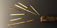 The Gudenushöhle cave is situated 20 km northwest of the city of Krems, in the valley of the Little Krems, not far from Willendorf, in Lower Austria. The site is close to the River Danube, and has yielded both Neanderthal and Magdalenian artefacts, including many tools, as well as an engraved reindeer bone and a fragment of a bone flute dated to about 18 000 – 12 000 BP.
Last updated Sunday 25 December 2022
 During the Upper Palaeolithic, ice age hunters used the slopes of the Danube valley repeatedly. Willendorf is one such site, and although justly famous for the Venus of Willendorf, it is also an important Gravettian and Aurignacian site for the other artefacts found there.
Last updated Monday 26 December 2022
 The small cave of Les Eyzies or la Grotte Richard opens above the village of Les Eyzies-de-Tayac, on the right shore of the Beune. Its prehistoric occupation is established in the Upper Magdalenian. It has been largely forgotten, but is an important site.
Last updated Tuesday 20 December 2022
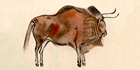
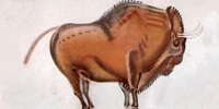 Altamira Cave is 270 metres long and consists of a series of twisting passages and chambers, and is decorated with ice age paintings. The artists used charcoal and ochre or haematite to create the images. They also exploited the natural contours in the cave walls to give their subjects a three-dimensional effect. The Polychrome Ceiling is the most impressive feature of the cave, depicting a herd of extinct Steppe Bison in different poses, two horses, a large doe, and possibly a wild boar. Around 13 000 years ago a rockfall sealed the cave's entrance, preserving its contents until its eventual discovery.
Last updated Saturday 28 September 2024
 La Madeleine is a rock shelter located in the Vézère valley, in the Dordogne, France. In 1926 the skeleton of a three year old child was discovered, with exquisite shell jewellery, dating from the end of the Magdalenian period. It is a treasure house of art and knowledge about the people of the Magdalenian. Several historic photographs, as well as modern ones of the gisement have been added, as well as much more information on the tools.
Last updated Thursday 12 December 2024
 Photoshop for beginners - I am not an expert, I am a beginner myself (though I have spent many years trying to understand a small part of this encyclopaedia for image manipulation), but this text and images may be of use to someone just starting out on the Photoshop journey. At the moment it covers part of rotation and cropping and healing of images, removing backgrounds, and healing just the edge of an object. I will be adding to this initial study as time affords.
Last updated Thursday 30 January 2025
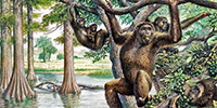 The swamp ape Oreopithecus bambolii was 120 cm tall and weighed 30 kg, with a brain capacity of up to 200 cm3 lived in swampy areas of what is now Italy, 10 to 8 million years ago. The long forelimbs are indicative of tree-dwelling. The ape went extinct after a land bridge connected their island to the mainland, allowing large saber-toothed cats and other predators to stalk the island.
Last updated Saturday 04 June 2022
 Achenheim is an important site from the Middle Palaeolithic (75 000 to 35 000 years ago) and bears witness to the presence of Neanderthal man in Alsace: Achenheim was an animal butchering area. The site includes the bones of several large animals (rhinoceros, horse, mammoth, bison, Megaloceros) butchered on the spot after the hunt.
Last updated Wednesday 11 May 2022
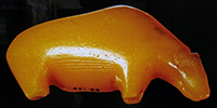 Magical amber animals - many of the Mesolithic period’s artistic masterpieces have been found in Denmark. Among them are bears, a bird and an elk of amber. The figures are elegant and shaped in a way that is true to nature. The people who made them must have had a good knowledge of how a real bear, and other animals, looked. Like many other amber finds from the Stone Age, the animal figures have been found in bogs or on beaches. Many appear to be amulets, and probably had great spiritual significance.
Last updated Saturday 27 April 2024
 Lalinde/Gonnersdorf figurines and engravings are strictly stylised, overtly female forms with over-sized buttocks, long trunks, small or missing breasts, and no heads. More information and images as well as plans and cross sections of the Gare de Couze and the Grotte de la Roche near the town of Lalinde have been added.
Last updated Saturday 21 October 2023
 The Venus of Willendorf is made of a rock called oolite, a form of limestone that is not found in or around Willendorf. Gerhard Weber and his team from the University of Vienna have now found out with the help of high-resolution tomographic images that the material from which the Venus was carved likely comes from northern Italy, at Lake Garda, about 700 km away.
Last updated Monday 26 December 2022
 Iron smelting was unknown in Egypt 3 400 years ago, yet a dagger from the tomb of Pharaoh Tutankhamun has been positively identified as having an iron blade made from metal extracted from a meteorite. It may have been a gift from Tušratta, king of Mitanni to Pharaoh Amenhotep III, who passed it on to his son, Akhenaten, who in turn passed it on to Tutankhamun.
Last updated Sunday 06 March 2022
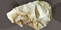
 Micoque tools - La Micoque is a Neanderthal site in the Dordogne dating from circa 400 000 BP to 130 000 BP. A number of tools have been added to the page.
Last updated Friday 25 February 2022
 Le Moustier is the type site for the Mousterian suite of tools and artefacts, and is a Neanderthal site. It is of interest primarily to those specialising in le Moustier and the lithic industry of the Mousterian. Several tools from Le Moustier have been added to this page.
Last updated Thursday 14 December 2023
 La Quina is a Neanderthal site located in the Charente region of south-western France. The artisans of the La Quina Mousterian industry type (thick asymmetric tools transformed many times) had a particular way of life: they were hunters specialising in the hunt for Reindeer or Bison, and they moved following the herds. Several tools from La Quina have been added to this page.
Last updated Thursday 11 August 2022
 Fontalès is a rock shelter and prehistoric site of the Magdalenian, which is in the commune of Saint-Antonin-Noble-Val , in Tarn-et-Garonne. It was excavated in 1865 by Victor Brun, then from 1936 to 1960 by Paul Darasse. The site has yielded a stratigraphic sequence comprising several levels of occupation dating from the Upper Magdalenian.
Last updated Saturday 19 February 2022
 La Grande Grotte de Saint-Front is a little over a kilometre upstream from Domme, on the left bank of the Dordogne. Also known as La Grotte du Mammouth, it contains a number of engravings and sculptures, including a superb Mammoth on a high ceiling.
Last updated Sunday 13 August 2023