 Bushwalking Index
Bushwalking, Hiking and Tramping in New Zealand
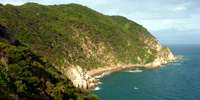 The Abel Tasman track follows the coastline along the north coast of the south island of New Zealand from Marahau to Wainui. It is a beautiful track with stunning coastal scenery, and the opportunity to take part in kayaking and guided walks, as well as catering for independent walkers.
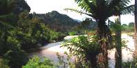 The Heaphy Track in New Zealand, 80 km long, has a wide variety of landscapes. It crosses the Southern Alps, taking the walker from the east to the west coast, through beech forests, alpine moors, mossy, very wet forests reminiscent of Lord of the Rings, a large and beautiful estuary at the entrance of the Heaphy River to the sea, then a superb walk along rocky and sandy ocean beaches, through groves of Nikau palms.
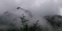 The Wangapeka track traverses the Southern Alps from the West coast to the eastern side of the mountains, passing through rainforest and alpine vegetation, as well as beautiful beech forests on the eastern side. It is a track for experienced, fit, self sufficient walkers. The huts rely on coal fires for warmth and cooking, and it is advisable to carry your own stove and fuel. There are many unbridged river and creek crossings, which may require a high level of experience to cross safely, or which may stop the walker entirely until conditions improve. You may well be the only person walking the track, and carrying a personal locator beacon is a wise precaution. Weather conditions can be extreme.
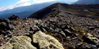 The Travers - Sabine Circuit in the Nelson Lakes area is a wonderful mix of landscapes and vegetation, from beech forest to alpine moors. It is suitable for experienced, fit walkers who are prepared to spend five to seven days exploring the wonderful areas the tracks give access to. The highlights are the Robert Ridge walk to Lake Angelus, the ascent of the Travers Saddle, and the trip to Blue Lake.
Bushwalking Index