Back to Don's Maps
Back to the index page for the Iron Gates
Click on the images for a larger view.

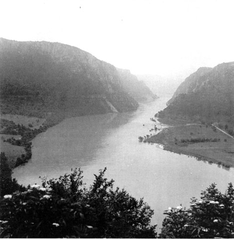
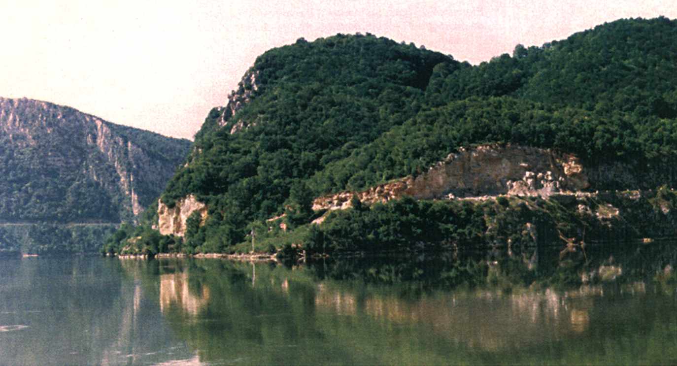
The Iron Gates Gorge
In the foreground, on the left, the terrace of the Hajducka Vodenica site. Lepenski Vir, Padina and Vlasac are further upstream in the narrow gorges. (Photo M.R. May 2000) This excellent photograph is by courtesy Mirjana Roksandic, B.A., M.A., D.E.A., Ph.D. from her website at http://www.erin.utoronto.ca/~mroksand/
Dr Roksandic's current academic position is at the University of Toronto at Mississauga, and is on the stipend faculty of the Department of Anthropology there.
Dr Roksandic is currently undertaking research and is the principal investigator for Burial Rituals in the Southern European Mesolithic: a Comparative Study of Two Regional Manifestations. Based on the ongoing excavations in the Muge Valley (Portugal) and re-analyses of documentation of previous excavations on the Iron Gates Gorge (Serbia) she is looking into the possibilities that a detailed analysis of burial rituals can offer in cross-cultural comparisons.
A General Overview of the Iron Gates
Most of the following text and photos are from the excellent monograph by I. Radovanović, 'The Iron Gates Mesolithic', 1996. It is essential reading for anyone hoping to get some understanding of the mesolithic in the Iron Gates region.
Those wishing to purchase it may print and snail mail a jpg format Order form for 'The Iron Gates Mesolithic' or a pdf format Order form for 'The Iron Gates Mesolithic'
Ivana Radovanović, who was appointed in 2001 as assistant professor of anthropology at the University of Kansas, Lawrence, taught for 18 years at the University of Novi Sad and at the University of Belgrade. She was also a research associate in the Institute of Archaeology in Belgrade. As a visiting scholar in the United Kingdom, she pursued research and lectured at the University of Durham, the University of Cambridge, and the University of Newcastle. Her areas of specialization include prehistoric technologies, archaeological record and interpretation of burial procedures, and ideology and belief systems of prehistoric hunter-gatherers. She earned doctorate, master's and bachelor's degrees in archaeology from the University of Belgrade.
(My translations of various place names are in italics, but should be treated with caution and a large grain of salt)
The Danube first enters the Golubac Gorge (Golub means Dove or Pigeon) (from Golubac downstream to the Liupkovska Valley). The width of the Golubac Gorge is around 400 m. The Danube cuts through Jurassic-Cretaceous limestones, granite, and other crystalline rocks and then flows into the Liupkovska Valley, (Ljupkost means grace, sweetness) with Pliocene (Levant) sediments. Upstream from the entrance to this gorge, is the island of Moldova Veche and the Mesolithic site of Alibeg on the left bank.
The second gorge, between the Liupkovska and Donji Milanovac valleys (Donji means lower) is called Gospodin Vir (The Lady's Whirlpool). The cliffs above it reach up to 500 m (the limestone massif of Sokolovac (Sokolov means of a hawk) reaches 590m, that of Coka Njalta 669 m above sea level), while the riverbanks are only 200 meters apart. The Danube cuts through greenish slate, Jurassic sandstones, and quartz porphyries. The whirlpools have been deepened by river erosion between rocks emerging from the riverbed up to the surface. This is the most inaccessible part of the Iron Gates Gorges on both banks. In spite of that, a number of Mesolithic sites have been discovered by survey on the left bank near llisova and IzIaz, (Izlaz means exit, outlet, way out) and several archaeological sites also have been found on the right bank. The archaeological site of Padina is situated on alluvial terraces (Sectors I and II) and in a fossil whirlpool filled with Quaternary sediments (Sector III). The erosive-accumulative fonnations such as the terrace above Lepenski Vir (The Whirlpool of Lepena) (Vir means whirlpool) near the mouth of Boljetinska River, or of Vlasac, are rare but they contain archaeological sites. The Donji Milanovac Valley is filled with Middle Miocene and transitional Middle-Upper Miocene sediments along the Porecka River on the right bank of the Danube. In the valley of Svinita, across the river, flint and chert locations exploited in prehistoric times have been discovered.
The third gorge encompasses the area between the Donji Milanovac and Orsava valleys and is called Kazan (The Cauldron). It is the narrowest of the Iron Gates gorges (150-170 m), where the Danube is 20-53 m deep, cutting through gabbro, Jurassic limestone, and crystalline rocks elevated almost vertically as much as 300 m above the riverbed (Veliki Strbac is 768 m, Mali Strbac 626 m above sea level). (Note that Veliki means large, great or big, Mali means small or little)The tectonic basins or depressions formed in the Neogene widen the gorge here and there- Plavisevita and Dubova in the Veliki Kazan (the Great Cauldron), and Ogradena (ograda means fence) in the Mali Kazan (the Small Cauldron), with relatively fast and easy exits to the mountain plateau above the left bank. Several archaeological sites were discovered in caves and rockshelters (Climente I and II, Cuina Turcului, Veterani) as well as open-air sites (Veterani Terrace) on the left bank of Veliki Kazan.
At Mali Kazan the open-air sites of Icoana and Razvrata on the left bank, and Hajducka Vodenica on the right bank, have been investigated. The Danube then enters the Orsava Valley, filled with Neogene sediments. Good communication with Baile Herculane (a cave site) in the hinterlands exists up the Cerna River.
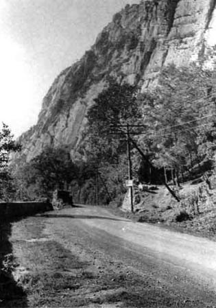
This is a relatively modern colour photograph taken showing the roads cut into the sides of the Iron Gates gorge, possibly before the flooding of Ada Kaleh.
Photo: Ada Kaleh CD
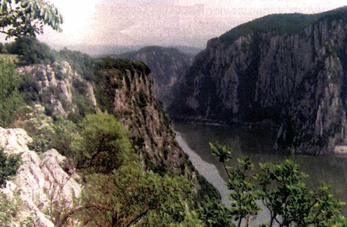
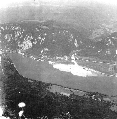
This is an early colour photograph of one of the gorges in the Iron Gates Gorges.
Photo: Ada Kaleh CD
The fourth gorge, called Sip, begins at the exit of the Danube from the Orsava Valley and ends at the edge of the Wallachian Plain. The Danube here cuts through the Miroc Plateau, which is built up almost vertically from shales, Jurassic-Cretaceous limestones and sandstones, and Upper Miocene conglomerates. At the spot called the Iron Gates (Djerdap, Pregrada, (Djerdan means necklace, Pregrada means partition wall) the entire region being named after it), uneroded rocks protrude out of the water, making rapids that have always been a great obstacle to safe river traffic. At the exit from the gorge are the archaeological sites of Ostrovul Banului (an island) (ostrovul means island) and Schela Cladovei on the left bank.
Then the Danube makes a large bend around the low plateau of Kljuc (The Riverbend). It flows to the southeast down to the island of Korbovo (Ostrovul Corbului with Mesolithic finds), then turns sharply to the northwest. After about ten kilometers it turns sharply again to the south and southeast. Mesolithic sites have been discovered downstream from Kljuc, at Ostrovul Mare (Great Island) and across the river, on the right bank, at Kula.
|
Ostrovu Mare |
The gorges of Golubac and Gospodin Vir, together with the Liupkovska and Donji Milanovac valleys, are often called the Upper Gorges, while the Kazan and Sip gorges, along with the Orsava Valley, are called the Lower Gorges. Communication by land between the Upper and the Lower Gorges was extremely difficult if not impossible until the Romans cut a road into the cliffs of Kazan. Communication by water was not less problematic because of the strong current, the whirlpools, and rapids. Travel through the Gorges to the Kljuc area and downstream was possible by water (although a long and dangerous voyage). However, a passage by land was probably used from the Upper Gorges and the Donji Milanovac Valley, across the Miroc Plateau and on to Kljuc and downstream. It was thus probably faster and easier to reach the Ostrovul Mare area downstream from the Upper Gorges by land (via Miroc) than from the Lower Gorges and Kljuc by land or water, and vice versa.
Geology
The canyonlike formations of the Iron Gates gorges are dominated by limestone massifs with typical karstic traits (sinkholes of various depths and sizes, karst grooves, cliffs, rock slips of various depths, ages, and dynamics, impasse valleys etc.). Sharply divided from the limestones is the siliceous bedrock in the valley-like parts of the Gorges. At some parts of the Gorges (Pecka Bara), (Peckati means to tease, Bara is a swamp or bog) the metamorphic rocks -sometimes protruding at the surface, especially in the coves- are covered by a thin layer of limestone that has affected the distribution of vegetation types. Scree material sliding down from the higher limestone slopes onto siliceous formations is also important. Besides the limestones (massive, red, sandy, marly, silicified), there are granite (at Brnjica (brnjica means an animal's muzzle) and Golubinje (golub means dove, pigeon ), green schist at Dobra (dobro means good or well), micaschists (at Boljetin, Tekija, and Sip), conglomerates and sandstones (at Pesaca and elsewhere), clayey schists and amphibolites (at Boljetin), gabbro (at Donji Milanovac), and sands, clays, sandy clays, and pebble formations (at Kljuc). The most diversified and complex area is between Bosman and the Boljetinska River (Upper Gorges), where there is a sequence of narrow belts of green schists, conglomerates and sandstones, micaschists, sandstone, massive and marly limestones, marls, red sandstones, argyloschists, etc. (Misic 1981:70).
Soils
According to Misic (1981:70-71) the soils in the Iron Gates region are different in types and variety and at different stages of development or degradation. The presence of limestone bedrock (above all, karstic) next to siliceous bedrock has caused the presence of different soil types. The limestone parent material developed a brown soil or brown rendzina and rendzina at different developmental stages. The karstic formations sometimes developed shallow, skeleton, organomineral rendzinas that have become degraded and reddish. The siliceous parent material developed brown acid soils with various percentages of sand and clay.
The mass movement of stones, rocks, and soils from the higher slopes has caused the formation of specific soil features which are not the products of pedogenesis. Such formations can be mainly of colluvial origin (erosive processes on the higher, steeper, and warmer slopes), but also of colluvial-alluvial, colluvial-proluvial (colluvial-deltaic, from slopes running down to streams), or simply alluvial origin. The thickness of such formations can be considerable (a few meters). In cases where vegetation has not stabilized the surface of these formations, they are still moving and regenerating. At some spots, pedogenesis has occurred on top of colluvial formations, creating a specific rendzinoid soil.
Vegetation and Climate
It is important to note (Radovanovic) that the climate in this area is milder than the surrounding areas, with warmer temperatures in winter (0.1 to 1.2 degrees higher in January) and cooler temperatures in summer (2 to 3.2 degrees lower in July). Annual rainfall within the Iron Gates is 20% higher than in neighbouring areas. Rainfall in the Iron Gates mostly ranges from around 600 mm to 700 mm p.a. (24 inches to 28 inches p.a.). Radovanović states: the configuration of the land, its altitude above sea level, and the character of its subsoils all have played a protective role against the harsh climatic oscillations felt in surrounding areas during the Pleistocene. Thus, even the greatest cooling in the last Ice Age did not change the vegetation types significantly. This is shown by the great number of relict species which have survived from the Tertiary to modern times. The refugial character of the Iron Gates Gorges is especially conspicuous at lower altitudes. At higher altitudes, a completely different vegetation type exists, more dependent on general climatic oscillations.
List of Dates for the Iron Gates sites
These are the oldest known dates for each area
| Alibeg horizon II | 7I95 B.P. |
| Padina A | 933I B.P. |
| Lepenski Vir Ia | 7360 B.P. |
| Vlasac II | 7937 B.P. |
| Cuina Turcului I | I2600 B.P. |
| Cuina Turcului II | I0I25 B.P. |
| Icoana II | 8605 B.P. |
| Razvrata II | 7690 B.P. |
| Ostrovul Banului III | 8040 B.P. |
| Ostrovul Corbului I | 8093 B.P. |
Revised and updated Chronology for the Iron Gates Region
| Stages | Sites | Uncorrected Dates |
| Early Neolithic | Vlasac IV; Ljubcova; Gornea; Stubica; Lepenski Vir III; Cuina Turcului III | 5495 +- 80 BC |
| Transitional Meso-Neo | Alibeg; Ostrovul Mare III | 5245 +- 100 BC |
| Mesolithic Later | Vlasac II and III; Lepenski Vir I and II; Padina A and B; Ostrovul Corbului III; Razvrata II; Schela Cladovei II; Ostrovul Banului IIIb; Ostrovul Mare I; Icoana II | 5980 -5200 BC |
| Mesolithic Earlier | Vlasac I; Osturovul Banului IIIa; Icoana Ia and b; Veterani Terasa; Razvrata Ia and b; Schela Cladovei I | 6315 - 6000 BC |
| Initial Post Pleistocene | Cuina Turcului II; Baile Herculane II | 8175 +- 200 BC |
| Terminal Pleistocene | Cuina Turcului I | 10 650 +- 120 BC |
The following is from the Iron Gate Complex Atlas by the Academy of the Socialist Republic of Romania.
The Palaeolithic
By Florea Mogosanu
The Middle Palaeolithic
At Gornea (Sichevita commune, Caras-Severin department) on the Caunita hill a temporary settlement was unearthed that belonged to the Middle Palaeolithic. Despite the scarcity of the tool inventory, both typologically and technological.ly it can be considered as typical Mousterian with Levallois debitage.
In a gallery of the cave Pestera Hotilor (Thieves' Cave) at the Baile Herculane Spa several quartzite implements were found, in a deposit lying on the cave's floor. It is a culture whose poor typology and rudimentary -technology ascribable to the Alpine Mousterian or the Alpine Palaeolithic was preserved in the caves of the Southern Carpathians.
In the Cazanele Mari (Veliki Kazan, Large Cauldron) at Climente Cave carved in the Ciucarul Massif (160 metres above water level), sporadic traces that belonged to the same Alpine Mousterian were also identified.
As far as investigations have revealed, these three settlements are the earliest remains in the Iron Gate area, about 40 000 - 35 000 years BC.
The Upper Palaeolithic
Still at Climente's Cave poor evidence has also been found (silex implements) ascribable to the Upper Gravettian, probably of southern (Italian) origin (about 12,000 years BC).
Then, at Gornea, on the Pazariste hill, a settlement was unearthed belonging to the Final Upper Palaeolithic (about 12,000 years BC) with a poor flint industry where macrolithic flakes with scantily retouched edges used as scrapers prevailed.
These two settlements mark the close of the Palaeolithic Age in the Iron Gate area.
The Epipalaeolithic
The Early Epipalaeolithic
By Alexandru Paunescu
As far as the Early Epipalaeolithic is concerned, it can be said that investigations conducted in the area led to the uncovering of five settlements - at Dubova in the Cuina Turcului shelter, Pestera de la Drum = Climente II, Veterani's Cave, at Gura Vaii on the Ostrovul Banului islet and at the Baile Herculane Spa in the Pestera Hotilor (Thieves Cave) the most important of all being that of the rock shelter at Cuina Turcului, where two occupation layers were identified (C14 dates: 10,650 +- 120 and 8175 +- 200 years B.C).
The lithic inventory found there is for the most part made of flint and only a very small percentage of obsidian. Interesting to note is that these are mostly small-sized artifacts (microliths).
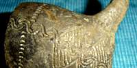
Besides the rich lithic material and the comparatively small number of bone and horn implements, red and yellow ochre fragments, articles of personal adornment, of prime value are also several art objects unearthed at Cuina Turcului. They are manufactured of bone and horn having an incised geometrical motif. Of these, noteworthy is an Equus phalanx (phalanx 1), ornamented throughout, that might well represent an anthropomorphic form. Considering this geometric ornamentation, as well as the lithic and bone inventory found at Cuina Turcului and in some Italian settlements too (the Romonelli, Maritza caves) we feel inclined to believe that the southern part of Banat at least belonged to the large Mediterranean zone at the end of the Palaeolithic and beginning of the Epipalaeolithic.
The Late Epipalaeolithic
Vasile Boroneant
As a consequence of the warmer post-glacial climate, a specific fauna and flora developed. Little by little, the hunters', fishermen' and fruit-collectors' Romanellian communities expanded their food basis; plants were increasingly resorted to for food. From the caves and rock shelters man settled in open encampments, on the Danube banks, as proved by the new settlements at Schela Cladovei, on the Ostrovul Banului islet at Gura Vaii, at the points Icoana and Razvrata in the Cazanele Mici at Ogradena, at Dubova, downhill from Veterani's Cave.
Silex was no longer the main raw material; quartzite and quartzitic rocks were used instead and horn and wild boar teeth working was extensively developing. New implements, such as hoes and blades, mirrored the process of turning to plant food. Wild boar teeth tools of the scrapers, chisels, perforators type gradually replaced some of the silex-made implements.
Referable to the third stage are stone-slab bordered rectangular hearth dwellings. And still from this stage, evidence was found, around the dwellings, of the red ochre burials according to the Palaeolithic tradition.
The bearers of this new culture, called of the Schela Cladovei type (about 7000-6000 years BC), continued the artistic tradition of the Romanellian, as results from the abstract geometric style of the unearthed ornamented objects.
Pollen analysis points to the existence of pollen grains which, by their size, might have belonged to the Cerealia species, whereas bone studies reveal a controlled exploitation of Suidae (pigs). Hunting was among the chief occupations.
The last stage of this culture is thought to have been found at the mouth of the Alibeg river, in the Pescari commune area, which indicate the gradual evolution to a new epoch, that of polished stone (the Neolithic). Polished stone was also known in the earlier stages, but it was only now that improved types appeared, alongside with ceramic, using the ornamental motifs of the preceding stages. The finds presented show proof of a continuous evolution of human communities in this area.
The archaeological researches concerning the Palaeolithic and the Epipalaeolithic have been carried out by Constantin Nicolaescu-Plopsor (chief of the archaeological team), Alexandra Bolomey, Vasile Boroneant, Marin Carciumaru, Florea Mogosanu, Alexandru Paunescu, and Stefan Roman.
The Neolithic
Eugen Comsa
By 1961, when the research work of our group was started, only two neolithic sites had been known ever since the turn of the century, and the information they provided was very scanty.
By the researches and excavations of our group-workers in the Iron Gate area, far more neolithic complexes have been made known and, what is even more important, the results of excavations not only make the historic evolution of the neolithic communities in the area quite easy to be followed, but also enable us to precisely state the time-span of each separate culture, especially the contents of each development stage. This actually helps elucidating some important problems of the SE European Neolithic.
Until quite recently, the early beginnings of the Neolithic period were a difficult question for a large part of Romania's territory. In the Iron Gate zone a number of complexes, called of the Schela Cladovei type, were excavated and are considered by the finder to belong to the final stage of the Epipalaeolithic. Our opinion is that, taking into account a few specific elements, some of these settlements may be looked upon as belonging to the beginning of this period (e.g. the Alibeg point at Pescari).
The Starcevo culture of the early Neolithic (about 5500 - 4000 years BC) is represented in the area by several complexes from different evolution stages. The earliest Starcevo-type settlements are those from Dubova, in the rock shelter called Cuina Turcului, and at Climente's Cave. At Cuina Turcului life was attested over a long time-span. In the settlement area numerous small silex tools were found, together with polished stone axes and bone implements which are proof of the various occupations: fishing, hunting and, to a small extent only, plant cultivation and stock breeding (pigs, cattle, sheep, goats, dogs). It is worth mentioning that at Cuina Turcului, besides the common-use pottery, a few sherds with a black-pointed motif against a red background were also found. Other Starcevo-type finds are known at Liubcova, Gornea, Moldova Veche and Pojejena.
Architecture of the area
At Lepenski Vir a very large number of house floors and hearths were preserved. Proto-Lepenski Vir is represented by 8 dwellings which had very clear rectangular stone-bordered hearths but no evidence of cut-in walls, tent stones, post holes or other traces of the construction of the dwellings. Very little of this settlement was excavated. Lepenski Vir I, which has been subdivided into 5 occupations, Ia - Ie, had 85 excavated houses. Houses were constantly being renewed, and new houses built, sometimes on top of older ones - providing the basis for a subdivision into five stages. Phase Ia includes 22 houses and, on the basis of unexcavated areas and probable destruction of some early houses by later building activity, may have contained up to 30 houses originally. House floor shapes are trapezoidal. House floors were poured from a heated mixture of crushed limestone, water, sand and gravel which hardened when it cooled, and covered the whole floor area and hearth. (N.B. This comes perilously close to a formula for concrete! - Don) Steeper trenches surrounded the 2 convergent sides and the short end, and post holes were dug into them to form the sloping roof which began at ground level. The backs of many houses were dug into the hillside. All but two houses faced the river. Floor area varied from 5.5 to 28 square meters. The largest (28 sq. meters) house was located in the middle of the settlement facing a central space free of houses, which was leveled with a retaining wall.
Phase Ib involved the renovation of 4 houses, including the 28 square meter one, and the construction of 22 new houses, mostly on top of old ones and taking advantage of the flat foundation they provided, sometimes increasing the size of the floor area. During Phase Ic, seventeen houses remained in use, and ten new houses were built. Among them were two new houses as large as the original large central one and two "miniature" houses with floor areas of 1.4 and 1.9 square meters. These latter houses had no debris on their floors. During phase Id seventeen new houses were built, and one of the newer (from Ic) large houses was rebuilt. The distribution of house floors suggests a splitting of the settlement, with one larger house in each half. During this stage, hearths began to be surrounded, on one or both sides, by triangles or A's, made from vertically set slabs of rock, with the point toward the hearth. (N.B. These A shaped symbols or constructions have not been satisfactorily explained - Don)This arrangement was found in two houses in stage Ic, and in all Id houses.
Phase Ie included the construction of a huge new central house (36 square meters) as well as a number of other new houses of smaller proportions.
Phase II was built on the deposits of Phase I--and all construction was new. One large central house and five smaller ones have been preserved, and there are traces of 38 other structures which were largely destroyed by the Lepenski Vir III occupation. The triangles or A's around the hearths still occur, the limestone flooring is gone.
The site of Padina is located on a long narrow beach. Padina B is called early Neolithic by the excavator (Jovanovic, 1968, 'Elements of the Early Neolithic Architecture in the Iron Gates Gorge and Their Functions', Archaeologica Iugoslavica IX, pp 1-9), largely on the basis of pottery found on house floors. Other archeologists believe Padina B to be Mesolithic. House floors were leveled with a yellow clay mixture, rectangular hearths with vertical stone slab borders surrounded by vertical stone slab triangles or A's, and a great mass of fish bones covered the areas around most hearths. Where preserved, the ground plans are trapezoidal. Padina A, which underlies B, is described as having the same architectural character.
Descriptions of architectural remains on the Romanian side are few and far between. Veterani Terasa, Icoana Ia and Razvrata Ia are reported to have oval floor plans with central post holes and circular hearths without borders. Schela Cladovei I, Icoana Ib, Razvrata Ib, and Ostrovul Banului IIIa have circular or oval hearths with stone borders. Razvrata II, Schela Cladovei II, Ostrovul Banului IIIb, Ostrovu Mare I and Icoana II have square or rectangular hearths with stone borders inside houses. Paved floors of red earth, sand and clay are reported from Ostrovul Banului. There are also circular unbordered hearths outside in the open at these sites. The very late site of Alibeg also had a rectangular rock-bordered hearth, but the rocks show evidence of shaping and the whole structure has been plastered over with some sort of coating. These hearths are inside dwellings, and other simpler hearths are in the open. At Ostrovu Mare the upper level, which is described as having 'baked clay' hearths, may be the same as that described for Alibeg.
The temporal relation between round or oval and rectangular hearths is well-documented at Vlasac and has been used as central evidence in establishing the relative chronology of the Iron Gates sites. On the basis of the evidence available, it seems clear that the whole sequence of sites in the Iron Gates architecturally looks like the work of a single population which continued through several thousand years to occupy this region.
Herbs of the Iron Gates
From: The Iron Gate Complex Atlas
In the native flora of the zone flooded by the waters of the storage lake some 73 species of medicinal herbs have been identified. Out of these 34 are also honey plants. Of the medicinal herbs, some 55 species (28 of which are shown below) are exceptionally important by their quantity and value.
Some of these plants occur in large amounts and have a high value e.g.. Aristolochia clematitis (Birthwort, 10 500 kg rhizomes), Verbascum speciosum and V. phlomoides (Mullein, 540 kg flowers) Rubus div. sp. (strawberry, 5 400 kg), Prunus spinosa (Blackthorn, 720 kg flowers), Tilia tomentosa (Silver Linden, 1 550 kg flowers)
Among the species of average importance by their quantity and value are: Arctium lappa (Burdock, 1 200 kg roots), Cotinus coggygria (Smoke tree, 1 500 kg leaves), Malva silvestris (French Mallow, 720 kg leaves) Melissa officinalis (Lemon balm, 620 kg leaves), Saponaria officinalis (Soapwort, 400 kg roots).
Some of the medicinal herbs of lower importance are: Sambucus nigra (Elderberry, 200 kg flowers), Urtica dioica (Stinging Nettle 800 kg folium), Hypericum perforatum (St. John's Wort, 400 kg herbs), Datura stramonium (Datura, 200 kg leaves).
The main medicinal herbs and honey producing plants in the Iron Gate zone (Bazias - Gura Vaii) are listed below:
| Achillea millefolium | Yarrow | |
| Arctium lappa | Burdock | Honey |
| Aristolochia clematitis | Birthwort | |
| Artemisia absinthium | Wormwood | |
| Bellis perennis | Marguerite | |
| Cichorium intybus | Chicory | Honey |
| Cotinus coggygria | Smoke tree | |
| Crataegus monogyna | European hawthorn | Honey |
| Datura stramonium | Datura, Thorn Apple, Jimson Weed | |
| Equisetum arvense | Common Horsetail | |
| Fragaria viridis | Hill Strawberry | |
| Hypericum perforatum | St. John's Wort | |
| Malva silvestris | French Mallow | Honey |
| Matricaria chamomilla | German chamomile | |
| Melissa officinalis | Lemon balm | Honey |
| Mentha longifolia | Horse mint | Honey |
| Plantago media | Hoary Plantain | |
| Populus nigra | Black Poplar | Honey |
| Prunus spinosa | Blackthorn tree, Blackthorn, Sloe | Honey |
| Robinia pseudacacia | Yellow Locust Tree | Honey |
| Rubus div. sp. | Blackberry | Honey |
| Sambucus ebulus | Dwarf Elder | |
| Sambucus nigra | Elderberry | |
| Saponaria officinalis | Soapwort | |
| Taraxacum officinale | Dandelion | Honey |
| Teucrium chamaedrys | Germander | Honey |
| Tilia tomentosa | Silver Linden | |
| Verbascum speciosum | Mullein | |
| Verbascum phlomoides | Mullein |
Modern Flora of the Iron Gates Gorge
| Acer monspessulanum | Montpelier Maple |
| Berberis vulgaris | Berberis |
| Carpinus orientalis | Hornbeam |
| Celtis sp. | hackberry |
| Ceterach officinarum | Finger fern |
| Clematis vitalba | Traveler's joy |
| Cotinus cozzygria | Smokewood |
| Cornus mas. | Cornelian Cherry |
| Crataegus nigra | Hawthorn |
| Dactylis glomerata | Cock's foot grass |
| Eunonymus verrucosa | Spindle-tree |
| Euphorbia cyparissios | Cypress spurge |
| Fagus sp. | beech |
| Festuca ovinz | Sheep's fescue |
| Fraxinum excelsior | Common ash |
| Fraxinus ornus | Manna ash |
| Geum urbanum | Common avens |
| Hedera helix | Common ivy |
| Juglans sp. | walnut |
| Lithospermum purpurescoeruleum | Purple gromwell |
| Pirus communis | Wild pear |
| Platanus sp. | sycamore |
| Prunus mahaleb | St. Lucie Cherry |
| Quercetum mixtum | Oak |
| Quercus cerris | Turkey Oak |
| Quercus pubescens Appenine | Oak |
| Quercus sessilia | Sessile Oak |
| Rosa spp. | Rose |
| Ruscus aculeatus | Butcher's broom |
| Sedum maximum | Stonecrop |
| Sorbus domestica | Service |
| Sorbus torminalis | Wild service |
| Syringa vulgaris | lilac |
| Thymus glabrescens | Thyme |
| Tilia argentea | Linden |
| Tilia grandifolia | Linden |
| Tilia parvifolia | Linden |
| Ulmus sp. | elm |
| Vigernun lantana | Wayfaring tree |
| Viola silvestris | Wood violet |
Sedum maximum Stonecrop Viola silvestris Wood violet Festuca ovinz Sheep's fescue
Evidence of animals from the Epipaleolithic and the Mesolithic in the Iron Gates Region
Epipaleolithic | ||||
| Species | Climente II | Cuina Turcului I | Cuina Turcului II | Padina A |
| Hedgehog | + | - | - | - |
| Wolf | - | 7.3% | 12.0% | 0.54% |
| Red fox | + | 2.2% | 4.7% | 0.54% |
| Brown bear | + | 5.0% | 2.3% | 2.73% |
| Wild cat | - | 2.2% | 2.3% | 0.36% |
| Wild pig | + | 17.7% | 2.3% | 5.0% |
| Chamois | - | 7.3% | 12.0% | 0.27% |
| Aurochs | - | 2.2% | 14.2% | 8.02% |
| Red deer | + | - | 2.3% | 79.94% |
| Roe deer | - | 7.3% | 2.3% | 3.37% |
| Beaver | + | 17.7% | 2.3% | 3.37% |
| Brown hare | - | 2.2% | 4.7% | 0.36% |
| Pelican | - | - | + | - |
| Raven | - | + | + | + |
| Wild horse | - | 2.2% | 2.3% | + |
| Mute swan | - | - | - | + |
| Greylag goose | - | + | - | + |
| Mergansers | - | - | + | - |
| Divers | - | - | + | + |
| Ibex? | 12.2% | 19.4% | - | - |
| Elk? | 7.3% | 2.3% | - | - |
| Grouse and partridge | ? | + | + | - |
Mesolithic | |||||
| Species | Icoana | Vlasac | Lepenski Vir I | Lepenski Vir II | Haijducka Vodenica I/II |
| Hedgehog | - | + | - | - | - |
| Wolf | 0.23% | 1.05% | - | - | - |
| Red fox | - | 0.30% | - | - | - |
| Brown bear | 0.41% | 1.72% | - | - | 0.95% |
| Wild cat | 0.18% | 0.46% | - | - | - |
| Wild pig | 53.35% | 12.16% | 5.46% | 3.94% | 10.95% |
| Chamois | 0.57% | 0.22% | - | - | 0.47% |
| Aurochs | 0.54% | 0.55% | 7.65% | 4.60% | 1.42% |
| Red deer | 38.58% | 69.08% | 62.84% | 73.02% | 83.80% |
| Roe deer | 6.20% | 5.23% | 2.18% | 0.65% | 0.47% |
| Beaver | 0.89% | 0.72% | 1.09% | - | - |
| Brown hare | 0.28% | 0.22% | - | - | - |
| Pelican | - | + | - | - | - |
List of all the animal species recorded at Epipaleolithic and Mesolithic sites in the Iron Gates
| INSECTIVORA | ||||
| Species | Common Name | Biotope | Use | Site |
| Erinaceus europaeus | hedgehog | Dry grounds and bushes | Meat | Climente II |
| Vlasac ? | ||||
| Padina B (Sector I and III) | ||||
| CARNIVORA | ||||
| Canidae | ||||
| Canis lupus | wolf | Forest and mountainous areas | Fur, meat (?) | Climente II |
| Cuina Turcului I | ||||
| Cuina Turcului II | ||||
| Icoana | ||||
| Vlasac | ||||
| Padina A (Sector I and II) | ||||
| Padina B (Sector I and III) | ||||
| Lepenski Vir III | ||||
| Canis sp. | wolf/dog | Icoana | ||
| Vlasac | ||||
| Padina B (Sector I and III) | ||||
| Hajducka Vodenica ? | ||||
| Canis familiaris | dog | Vlasac | ||
| Padina A (Sector I and II) | ||||
| Padina B (Sector I and III) | ||||
| Lepenski Vir I | ||||
| Lepenski Vir II | ||||
| Lepenski Vir III | ||||
| Hajducka Vodenica I | ||||
| Hajducka Vodenica II | ||||
| Vulpes vulpes | red fox | Dry grounds, various biotopes | Fur, meat (?) | Climente II |
| Cuina Turcului I | ||||
| Cuina Turcului II | ||||
| Vlasac | ||||
| Padina A (Sector I and II) | ||||
| Lepenski Vir III | ||||
| Ursidae | ||||
| Ursus arctos | brown bear | Dense forests | Fur, meat | Climente II |
| Cuina Turcului I | ||||
| Cuina Turcului II | ||||
| Icoana | ||||
| Vlasac | ||||
| Padina A (Sector I and II) | ||||
| Padina B (Sector I and III) | ||||
| Hajducka Vodenica ? | ||||
| Lepenski Vir III | ||||
| Felidae | ||||
| Felis silvestris | wildcat | Sparse forest or forest/steppe | Fur, meat | Climente II |
| Cuina Turcului II | ||||
| Icoana. | ||||
| Vlasac | ||||
| Padina A (Sector II and I) | ||||
| Padina B (Sector I and III | ||||
| Lepenski Vir III | ||||
| Lynx lynx | lynx | Forests | Fur | Icoana |
| Vlasac | ||||
| Padina A (Sector I and II) | ||||
| Padina B (Sector I and III) | ||||
| Lepenski Vir III | ||||
| Mustelidae | ||||
| Mustela nivalis | weasel | various, near human settlements | - | Vlasac |
| Lepenski Vir I | ||||
| Lepenski Vir II | ||||
| Lepenski Vir III | ||||
| Putorius putorius | polecat | Fields, meadows, swamps | - | Cuina Turcului II |
| Martes martes | pine marten | Deciduous and coniferous forests, mountains, rocky grounds | Fur | Cuina Turcului I |
| Cuina Turcului II | ||||
| Icoana | ||||
| Vlasac | ||||
| Padina A (Sector I and II) | ||||
| Padina B (Sector I and III) | ||||
| Lepenski Vir III | ||||
| Hajducka Vodenica ? | ||||
| Meles meles | badger | Deciduous forest | Fur, meat(?) | Icoana |
| Vlasac | ||||
| Padina A (Sector I and II) | ||||
| Lepenski Vir I | ||||
| Lepenski Vir III | ||||
| Padina B (Sector I and III) | ||||
| Lepenski Vir III | ||||
| Lutra lutra | otter | Riversides, swamps | Fur, meat | Cuina Turcului I |
| Icoana | ||||
| HERBIVORA | ||||
| Artiodactyla | ||||
| Sus scrofa | wild boar | Mixed deciduous forest near the water | Meat, leather, tusks | Climente II |
| Cuina Turcului I | ||||
| Cuina Turcului II | ||||
| Icoana | ||||
| Vlasac | ||||
| Padina A (Sector I and II) | ||||
| Padina B (Sector I and III) | ||||
| Hajducka Vodenica I | ||||
| Hajducka Vodenica II | ||||
| Lepenski Vir III | ||||
| Capra ibex | ibex | High mountains | Meat, leather, bone, horn | Cuina Turcului I |
| Cuina Turcului II | ||||
| Rupicapra rupicapra | chamois | Mountain forests | Meat, leather, bone, horn | Cuina Turcului I |
| Cuina Turcului II | ||||
| Icoana | ||||
| Vlasac | ||||
| Padina A (Sector I and II) | ||||
| Hajducka Vodenica I | ||||
| Lepenski Vir III | ||||
| Rupicapra rupicapra | chamois | Mountain forests | Meat, leather, bone, horn | Cuina Turcului I |
| Cuina Turcului II | ||||
| Icoana | ||||
| Vlasac | ||||
| Padina A (Sector I and II) | ||||
| Hajducka Vodenica I | ||||
| Lepenski Vir III | ||||
| Ovis/Capra | sheep/goat | Padina A (Sector I and II) | ||
| Padina B (Sector I and III) | ||||
| Bos primigenius | aurochs | Various biotopes | Meat, leather, bone, horn | Climente II |
| Cuina Turcului I | ||||
| Cuina Turcului II | ||||
| Icoana | ||||
| Vlasac | ||||
| Padina A (Sector I and II) | ||||
| Padina B (Sector I and III) | ||||
| Lepenski Vir I | ||||
| Lepenski Vir II | ||||
| Lepenski Vir III | ||||
| Hajducka Vodenica I | ||||
| Bos taurus | domestic cattle | Various biotopes | Meat, leather, bone, horn | |
| Padina A (Sector I and II) | ||||
| Padina B (Sector I and III) | ||||
| Lepenski Vir III | ||||
| Hajducka Vodenica II | ||||
| Bison cf. priscus | bison | Deciduous forests with open spaces, steppe | Meat, leather, bone, horn | Climente II |
| Cuina Turcului I | ||||
| Cuina Turcului II | ||||
| Icoana | ||||
| Alces alces | elk | Swampy forests | Meat, leather, bone, antler | Climente II |
| Cuina Turcului I | ||||
| Cuina Turcului II | ||||
| Cervus elaphus | red deer | Various biotopes | Meat, leather, bone, antler | Climente II |
| Cuina Turcului II | ||||
| Icoana | ||||
| Vlasac | ||||
| Padina A (Sector I and II) | ||||
| Padina B (Sector I and III) | ||||
| Lepenski Vir I | ||||
| Lepenski Vir II | ||||
| Lepenski Vir III | ||||
| Hajducka Vodenica I | ||||
| Hajducka Vodenica II | ||||
| Capreolus capreolus | roe deer | Various biotopes | Meat, leather, antler | Climente II |
| Cuina Turcului I | ||||
| Icoana | ||||
| Vlasac | ||||
| Padina A (Sector I and II) | ||||
| Padina B (Sector I and III) | ||||
| Lepenski Vir I | ||||
| Lepenski Vir II | ||||
| Lepenski Vir III | ||||
| Hajducka Vodenica ? | ||||
| Perissodactyla | ||||
| Asinus hydruntinus | wild ass | steppe | Meat, leather, bone | Lepenski Vir III |
| Equus caballus | wild horse | steppe | meat, leather, bone | Climente II |
| Cuina Turcului I | ||||
| Icoana | ||||
| Vlasac | ||||
| Padina A (Sector I and II) | ||||
| RODENTIA | ||||
| Sciuromorpha | ||||
| Castor fiber | beaver | Deciduous forest near water | Fur, meat, incisors | Climente II |
| Cuina Turcului I | ||||
| Cuina Turcului II | ||||
| Icoana | ||||
| Vlasac | ||||
| Padina A (Sector I and II) | ||||
| Padina B (Sector I and III) | ||||
| Lepenski Vir I | ||||
| Lepenski Vir III | ||||
| Sciurus vulgaris | squirrel | Forest | - | Vlasac? |
| LAGOMORPHA | ||||
| Lepus europaeus PALLAS | ||||
| Lepus capensis | brown hare | Open spaces, various biotopes | Meat, leather, bone | Cuina Turcului I |
| Cuina Turcului II | ||||
| Icoana | ||||
| Vlasac | ||||
| Padina A (Sector I and II) | ||||
| Padina B (Sector I and III) | ||||
| Lepenski Vir III | ||||
| AVES | ||||
| Lepenski Vir I-III | ||||
| GALLI | ||||
| Tetrao urogallus | capercaillie | Dense mixed forests | - | Cuina Turcului I |
| Tetrao tetrix | grouse | Barren lands and swamps | - | Cuina Turcului II |
| Alectoris graeca | rock partridge | Rocky grounds | meat | Cuina Turcului I |
| ANSERES | ||||
| Cygnus cf. olor | mute swan | Riverbanks and lakes | Feathers | Cuina Turcului I |
| Padina A (Sector I and II) | ||||
| Anser anser | greylag goose | Swamps | Meat and feathers | Padina A (Sector I and II) |
| Anas platyrhynchos | mallard | Marshes with dense vegetation | Meat and feathers | Vlasac? |
| Anas crecca | teal | Dense coastal vegetation | Meat and feathers | Vlasac? |
| Tadorna tadorna | shelduck | Swamps (Black Sea) | Meat and feathers | Padina B (Sector I and III) |
| Aythya nyroca | ferruginous duck | Dense coastal vegetation | - | Vlasac? |
| Mergus serrator | red-breasted merganser | Sea coasts, mouths of rivers (Black Sea) | Meat, feathers | Cuina Turcului II |
| Mergus merganser | goosander | Sea coasts, mouths of rivers (Black Sea) | Meat, feathers | Cuina Turcului II |
| CRESSORES | ||||
| Egretta alba | great white egret | Coasts (swamp, lake, river) | Feathers | Vlasac? |
| ACCIPETRES | ||||
| milvus migrans | black kite | forests near water | Feathers | Vlasac? |
| Haliaetus albicilla | white-tailed eagle, sea-eagle | Wooded riverbanks | Meat, feathers | Vlasac? |
| Padina A (Sector I and II) | ||||
| Padina B (Sector I and III) | ||||
| Aquila heliaca | imperial eagle | Forest borders | Feathers | Vlasac? |
| Vultures | ||||
| Aegypius monachus | black vulture | |||
| Gypaetus barbatus | lammergeier | |||
| Gyps fulvus | griffon vulture | Rocky grounds, cliffs | - | Cuina Turcului II |
| Padina B (Sector I and III) | ||||
| STEGONOPES | ||||
| Pelecanus onocrotalus | white pelican | Swamps | Feathers | Cuina Turcului II |
| Vlasac? | ||||
| Padina B (Sector I and III) | ||||
| Phalacrocorax carbo | cormorant | Wooded riverbanks with shallow waters | feathers | Vlasac? |
| Padina A (Sector I and II) | ||||
| PYGODES | ||||
| Gavia stellata | red-throated diver | Low coasts of swamps and lakes (coming from the North) | Meat, feathers | Cuina Turcului I |
| Gavia arctica | black-throated diver | Low coasts of swamps and lakes (coming from the North) | Meat, feathers | Padina A (Sector I and II) |
| STRIGES | ||||
| Bubo bubo | eagle owl | Rocky grouds, coniferous forests | - | Cuina Turcului II |
| Strix aluco | tawny owl | Rocky grouds, coniferous forests | - | Vlasac? |
| PICI | ||||
| Picus viridis | green woodpecker | Forests | - | Cuina Turcului I |
| PASSERES | ||||
| Garrulus glandarius | - | - | - | Vlasac? |
| Pica pica | magpie | - | - | Cuina Turcului II |
| Vlasac? | ||||
| Nucifraga caryocatactes | nutcracker | - | - | Cuina Turcului I |
| Corvus monedula | jackdaw | - | - | Cuina Turcului I |
| Corvus corax | raven | Cliffs, high trees | Meat, feathers | Cuina Turcului I |
| Vlasac? | ||||
| Padina A (Sector I and II) | ||||
| Padina B (Sector I and III) | ||||
| Corvus frugilegus | rook | - | - | Cuina Turcului I |
| Padina B (Sector I and III) | ||||
| Pyrrhocorax graculus | alpine chough | - | - | Cuina Turcului I |
| Cuina Turcului II | ||||
| Sturnus vulvaris | starling | - | - | Cuina Turcului II |
| Fringillidae | finches | - | - | Cuina Turcului II |
| REPTILIA | ||||
| Emys orbicularis | European pond terrapin | Stagnant waters with dense vegetation | Meat | Vlasac? |
| Padina A (Sector I and II) | ||||
| Padina B (Sector I and III) | ||||
| Species | Common Name | Dwelling | Spawn | Use | Site |
| PISCES | unidentified species of fish | - | - | - | Hajducka Vodenica II |
| Acipenseridae | |||||
| Acipenser huso (Huso huso) |
beluga, Danube sturgeon | Black Sea, moves up the Danube during spawning | April-June, shallow waters | meat, roe, bladder (for glue) | Cuina Turcului II |
| Icoana | |||||
| Padina A (Sector I and II) | |||||
| Padina B (Sector I and III) | |||||
| Acipenser ruthenus | sterlet | Danube, riverbottom, moves upstream during spawning | May-June, sandy riverbottom | meat, roe, bladder (for glue) | Cuina Turcului II |
| Icoana | |||||
| Salmonidae | |||||
| Hucho hucho | Danube salmon | Danube with tributaries, big depths, whirlpools | March-April, shallow waters | meat | Padina A (Sector I and II) |
| Padina B (Sector I and III) | |||||
| Esox lucius | pike | river and lake coasts, calm and clear waters | February-May, reeds, flooded meadows | meat | Cuina Turcului I |
| Cuina Turcului II | |||||
| Vlasac | |||||
| Cypriniformes | |||||
| Leuciscus cephalus | chub | shoals | April-June | meat (of a lesser quality - lot of bones) | Cuina Turcului II |
| Icoana | |||||
| Vlasac | |||||
| Abramis brama | bream | slow waters, muddy waters, hibernation | May-June, shallow waters | meat (of a lesser quality - lot of bones) | Cuina Turcului I |
| Cuina Turcului II | |||||
| Icoana | |||||
| Cyprinus carpio | carp | warm, calm waters, riverbottom, hibernation | May-July, shallow waters with vegetation | meat | Cuina Turcului I |
| Cuina Turcului II | |||||
| Icoana | |||||
| Vlasac | |||||
| Padina A (Sector I and II) | |||||
| Padina B (Sector I and III) | |||||
| Lepenski Vir I | |||||
| Lepenski Vir II | |||||
| Lepenski Vir III | |||||
| Silurus glanis | wels (Danube catfish) | deep waters, muddy waters, hibernation | May-July, riverbank vegetation | meat | Cuina Turcului II |
| Icoana | |||||
| Vlasac? | |||||
| Padina A (Sector I and II) | |||||
| Padina B (Sector I and III) | |||||
| Lepenski Vir I | |||||
| Lepenski Vir II | |||||
| Lepenski Vir III | |||||
| Perciformes | |||||
| Perca fluviatilis | perch | clear waters, "shelters" deep in the water | March-May, shallow waters | meat | Cuina Turcului I |
| Icoana | |||||
| Vlasac? | |||||
| Padina A (Sector I and II) | |||||
| Padina B (Sector I and III) | |||||
| Lepenski Vir I | |||||
| Lepenski Vir II | |||||
| Lepenski Vir III | |||||
| Stizostedion lucioperca | pikeperch | deep but muddy (no sand) and cold waters | April-May, stones and branches | meat | Cuina Turcului I |
| Cuina Turcului II | |||||
| Icoana | |||||
| Species | Common Name | Site |
| MOLLUSCA | ||
| GASTROPODA | ||
| Helix sp. | edible land snail | Padina A (Sector I and II) |
| Padina B (Sector I and III) | ||
| Zebrina detrita | land snail | - |
| Melanopsis impressa? | fresh water snail | - |
| Theodoxus transversalis | fresh water snail | - |
| Theodoxus danubialis | fresh water snail | - |
| Nassa (Cyclope) neritea | marine snail | - |
| SCAPHOPODA | ||
| Dentalium dentalis fossilis | tusk shell | - |
| BIVALVIA | ||
| Unio crassus | fresh water mussel | Padina A (Sector I and II) |
| Padina B (Sector I and III) | ||
| Glycymeris sp. | marine clam | - |