 Bushwalking Index
The Travers - Sabine Circuit, Nelson Lakes, New Zealand
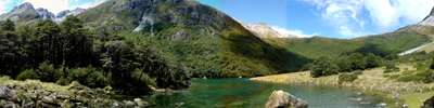
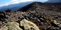 Day One and Two - The Travers - Sabine Circuit in the Nelson Lakes area is a wonderful mix of landscapes and vegetation, from beech forest to alpine moors. It is suitable for experienced, fit walkers who are prepared to spend five to seven days exploring the wonderful areas the tracks give access to. The highlights are the Robert Ridge walk to Lake Angelus, the ascent of the Travers Saddle, and the trip to Blue Lake. After driving from nearby Saint Arnaud, Paddy's track gives access to Bushline Hut, with views of Lake Rotoiti along the way. The well marked Robert Ridge track, narrow and exposed at times, takes you to Lake Angelus Hut, with spectacular views of glacial lakes and cirques along the way, and very interesting alpine vegetation such as vegetable sheep. Snow is possible any month of the year.
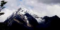
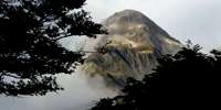
Day Three - The Travers - Sabine Circuit in the Nelson Lakes area is a wonderful mix of landscapes and vegetation, from beech forest to alpine moors. The Cascade Track from Lake Angelus has alpine vegetation such as Tikumu (Celmisia) and Hebe, and some beautiful waterfalls, before reaching the Travers River, with beech forests and lichens. There are superb views of Mount Travers before reaching the John Tait Hut. John Tait built the first hut in this area, and the Hut is named after him.
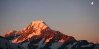
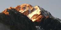 Day Four of the Travers Sabine Circuit in New Zealand - John Tait Hut to West Sabine Hut over the Travers Saddle. It is a steady climb to Upper Travers Hut, but the view of Mount Travers from the valley bottom is spectacular. Travers Falls is a beautiful little 20 metre high waterfall. From Upper Travers Hut the way leads up the Saddle, with some steep sections. There are many beautiful alpine plants such as Hebe, Celmisia, Gentiana, Helichrysum, Coprosma, vegetable sheep and New Zealand flax on the eastern side of the saddle. On the saddle itself there are some beautiful large tarns, but the area is exposed and often windy and cold. The track drops down into the East Branch of the Sabine, via a steep scree slope. The area is subject to avalanches after heavy snow.
 Day Five of the Travers Sabine Circuit in New Zealand - West Sabine Hut to Blue Lake. The West Sabine drains Lake Constance and Blue Lake, high in the catchment of the West Sabine. It joins the East Sabine at Sabine Forks, and the Sabine then flows into Lake Rotoroa, in the Nelson Lakes National Park. Apart from the upper reaches, which is open tussock and scrub, the river is set within unmodified beech forest. The West Sabine River is in a superb gorge, with many streams coursing down the flanks of the valley walls. After heavy rain, crossing sidestreams can be a very wet experience, and care must be taken.
 Day Six of the Travers Sabine Circuit in New Zealand - Blue Lake to Lake Rotoroa. The East and West Sabine rivers drain each side of the Mount Franklin massif, and the West Sabine drains Lake Constance and Blue Lake. They join at Sabine Forks, and the Sabine then flows into Lake Rotoroa, in the Nelson Lakes National Park. It is a beautiful stream bordered by beech forest, with lichens and fungi under the trees. A tramping track runs along the river and forms the western branch of the Travers-Sabine tramping circuit. It connects Lake Constance and Blue Lake with Lake Rotoroa and Lake Rotoiti. Three tramping huts are located in the Sabine Valley: Sabine Hut, West Sabine Hut, and Blue Lake Hut. Lake Rotoroa is fed by the D'Urville and Sabine Rivers. A track follows the north east side of the lake, and another track leads back via Speargrass Hut to St Arnaud. A water taxi can ferry trampers to and from the head of the lake. The lake has trout, and attracts recreational fishermen.
 Bushwalking, Hiking and Tramping in New Zealand
Bushwalking Index